

Florida map
Winter Springs map
About 39,822 people live here (Census Bureau, 2024 estimate). The sheet's index lists 300 streets; Winter Springs Boulevard, Tuskawilla Road and Northern Way cross the most grid squares. Also on it: Tuscawilla Country Club, Central Winds Park and Winter Springs Town Center.
Open the map (PDF, US Letter)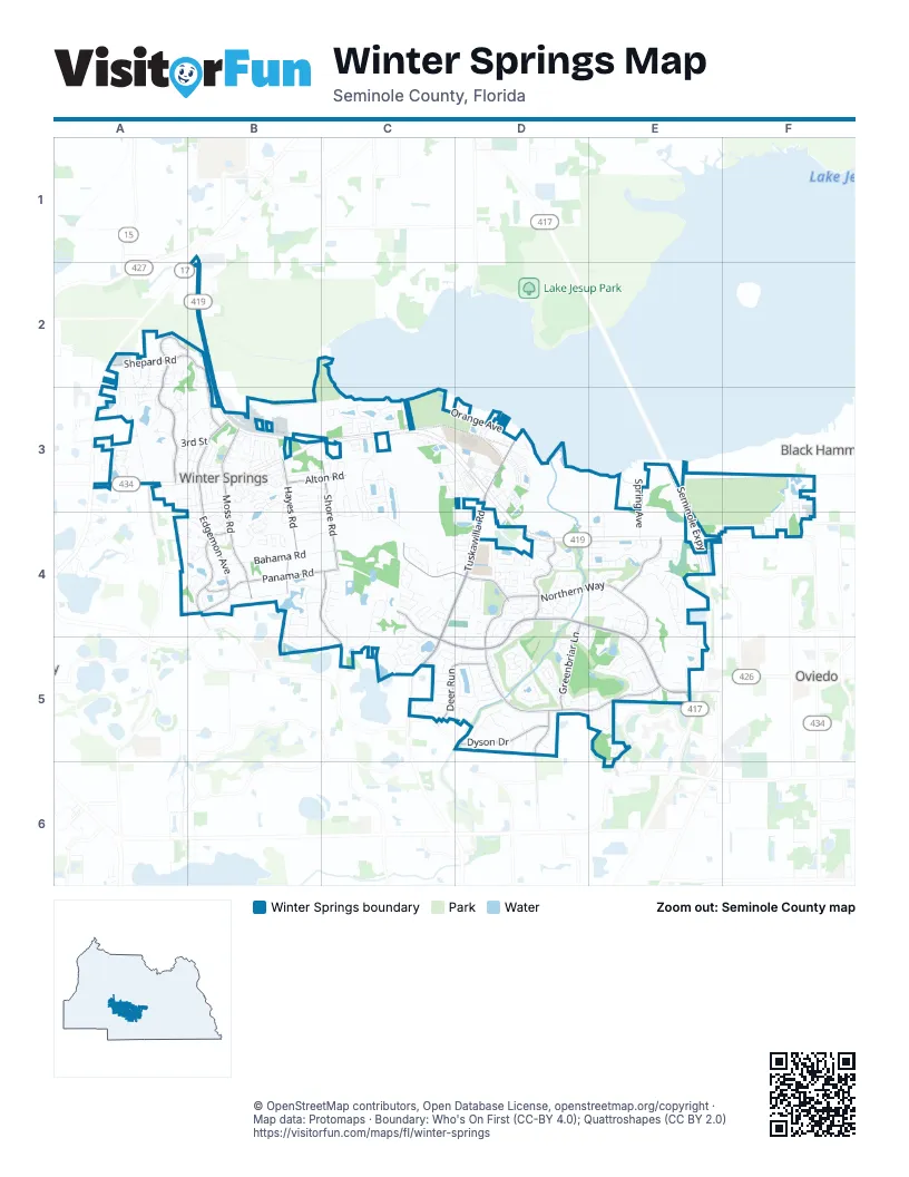
Street index of Winter Springs
Each street on the sheet and the grid squares it crosses.
- Seminole ExpresswayE3, E4, E5
- W SR 434F4
- Tuskawilla RoadD3, C4, D4, C5
- Winter Springs BoulevardC4, D4, E4, C5, D5, E5
- Northern WayD4, E4, D5, E5
- Sheoah BoulevardA2, A3
- Edgemon AvenueB3, B4
- Shepard RoadA2, B2, B3
- Moss RoadB3, B4
- Panama RoadB4, C4
- Trotwood BoulevardC4, D4
- Hayes RoadB3, B4
- Murphy RoadB4
- Shore RoadC3, C4
- Deer RunC5, D5
- Tuscora DriveD4
- Dyson DriveD5
- Fisher RoadB4, C4, C5
- Greenbriar LaneD4, D5
- Vistawilla DriveE4
- Sheoah CircleA2, B2
- Alton RoadB3, C3
- Shetland AvenueD5
- Dovera DriveE5
- Bird RoadC5
- Citrus RoadD5
- North Winter Park DriveA3
- Seneca BoulevardE4, E5
- Eagle Nest CircleE5
- Dolphin RoadB3, B4
- Bahama RoadB4, C4
- Dunmar CircleC4, C5
- Bear Creek CircleD4, E4
- Nandina TerraceD4, E4
- Tradewinds RoadB4, C4
- Morton LaneB4, B5, C5
- Chokecherry DriveC4, C5
- Winding Hollow BoulevardC3, C4
- Seville Chase DriveC4, C5
- Augusta National BoulevardD5
- Orange AvenueC3, D3
- Twelve Oaks DriveC3, C4
- Cortez AvenueB3, B4
- Central Winds ParkwayC3
- Seneca Meadows RoadC3
- Michael Blake BoulevardD3
- Sybilwood CircleD4
- Sailfish RoadB4, C4
- Andover CircleD4
- Casa Park CircleD4
- Tanglewood RoadA2, A3
- Mocking Bird LaneC3, C4
- Leopard TrailC5, D5
- David StreetB3
- Devon AvenueB3
- Casselberry LaneA3
- Tavestock LoopC3
- Holiday LaneC3, C4
- Howell Creek DriveD5
- Cheetah TrailC4, D4, D5
- Duncan DriveE5
- Tuskawilla TrailC5
- Fairfax AvenueB3
- Arabian AvenueD5
- Moree LoopA3
- Dancing Water DriveD4
- Seven Oaks BoulevardA2, A3
- Oscelot TrailC5, D5
- La Vista Drive EastB3
- MacGregor RoadA3, B3
- Belle AvenueA3
- Lancers DriveB4
- Sunrise AvenueB4, B5
- Saranac DriveE4
- Fanning BoulevardD3
- Pawnee TrailC3, D3
- Lombardy RoadA3, B3
- Milky WayC3, D3, D4
- Morgan StreetD5
- Arbor Glen CircleC4, D4
- Mount Laurel DriveD4
- Cherry Creek CircleD4
- Silver Creek DriveB3, C3
- Papaya LaneC4
- Bentley Green CircleD5
- Green Spring CircleB3
- Pheasant CircleC5
- Tuscany PlaceD4
- Big Buck CircleC4
- Spring AvenueE4
- Winding Chase BoulevardC4
- North Alderwood StreetB4
- 3rd StreetA3, B3
- Winding Waters CircleC3, C4
- Blumberg BlvdD3
- O'Day DriveC4
- Nighthawk CircleA3
- Tiverton StreetE4
- La Vista Drive WestB3
- Bombay AvenueA3, B3
- Wescott LoopF3, F4
- Benchwood DriveC4
- Tree Swallow DriveD3
- Blue Creek DriveE5
- Panama CircleA4, B4
- Sherry AvenueB3
- Whitehall BoulevardD4
- Williams RoadB4, C4, B5
- Cheoy Lee CircleC4, D4
- Maple Leaf LoopA2, A3
- Old Sanford Oviedo RoadB3
- Turkey Hollow CircleC4
- Antelope TrailD5
- Buttonwood AvenueA4, B4
- Timberwilde AvenueC3, C4
- Spring Pond PtE3, E4
- Stoner RoadB4, C4
- Wood Duck DriveE5
- Inglenook CircleB3, B4
- Pearl RoadB3, C3
- Gator LaneC5
- Casa Grande CourtB3
- Contravest LaneE4
- Mohawk TrailC3, D3
- Woodleaf DriveD4, D5
- Barrington CircleD4
- Cranston StreetF3, F4
- Wade StreetB3
- Laurel Oaks DriveA3
- Eagle Wind TerraceD4
- Partridge CircleD5
- Arrowhead CourtD4
- Endeavour Drive NorthD4
- 1st StreetB3
- Oak Forest DriveC4, C5
- Blenheim LoopC3
- Cruz Bay CircleC3
- Shadowbrook TrailC3, C4
- Avery Lake DriveC4, D4
- Coral WayB3, C3
- Jackson CircleB4
- Pleasant Grove DriveD4
- Stone Gable CircleC3
- Fountain Tree DriveA3
- San Gabriel StreetB3
- Glen Eagle DriveE5
- Forest CircleC4, C5
- Costa Rica DriveB3
- Mosswood CircleB4
- White Dove DriveE4, E5
- Heatherwood CourtD4
- Old White WayD5
- Silver Sea RoadA3
- Warrington StreetE4, E5
- Apache TrailC3, D3
- Cello CircleB4
- Harbor Winds CourtA3
- Ermine AvenueC5, D5
- Night Owl LaneC4
- Cayuga DriveE4
- Buckhorn DriveD3
- Seafarer LaneC4
- Tarpon CircleD5
- Gazell TrailD4, D5
- Parkstone BoulevardC3
- Pebble Beach Circle EastD5
- Wingspan WayE5
- Baltic LaneC4, D4
- Bonita RoadB4
- Marlin RoadB3
- Riunite CircleB4
- Swan StreetD5
- Integra Land WayE4
- Natures WayD3
- Rushing Rapids WayD4
- Fox Glen CourtD4, E4, E5
- Arnold LaneB4, C4
- Wilson RoadD4
- Carrington AvenueE4
- Bitterwood StreetB4
- Chestnut Ridge StreetD5
- Elderwood StreetB4
- Wildwood DriveA2
- Hicks AvenueC3
- Courtney Springs CircleE4
- Forest Hills DriveD4
- Marni DriveB2
- Via CaprettiC4, C5
- Saddlewood LaneC3
- Spotted Sandpiper LoopD3
- Stream View WayD4, E4
- McLeod's WayD3
- Royal Oak DriveD5, E5
- Stone Harbour RoadC3
- Park Lake DriveC3, D3, C4, D4
- Creekside CircleD4
- Peregrine CourtE4
- Glen Abbey CircleD5
- Galloway DriveA2, B2
- Pinebranch CircleF4
- Bennett StreetB3
- White Oak DriveD4
- Anhinga RoadA3
- Heritage Park StreetC3
- Adidas RoadD4
- Wolverine TrailC5, D5
- Swift Creek WayD4
- Oak RoadC3, C4
- Pebble Beach Circle WestD5
- Tides RoadB3, B4
- Golfpoint DriveE5
- Solarys Wharf StreetD3
- Endeavour Drive SouthC4, D4
- Town Plaza CourtD4
- George StreetB3
- Fruitwood AvenueB4
- Albert StreetB3
- Eagle Edge LaneD3
- Cheyenne TrailC3, D3
- Boxwood CircleB4
- Trailhead PointD4
- Panorama DriveB4
- Charles StreetB3
- Wagner PointC3
- Bear Creek CourtE4
- Bear Springs DriveD3
- Winged Foot Circle WestD5
- Nursery RoadA3
- Oxbow LaneD5, E5
- South Alderwood StreetB4
- Dunlap CircleD4
- Myrtle Oaks TrailF3, F4
- Benitawood CourtD4
- Taproot DriveC5
- Deer Song DriveB3
- Wedgewood Drive NorthD5
- Freedom LaneC4, D4
- Almaden CourtB3
- Nancy CircleD5
- Stratford DriveD5
- Ponce de Leon DriveB3
- Sequoia DriveC4, C5
- Lynx TrailC5, D5
- Casa Grande DriveB3
- Lisa LoopB3
- Sandringham CourtC3
- Sapling DriveC5
- Woodcrest StreetC3
- El Camino Real CircleB3
- Tradition LaneC3
- Venture CourtC4
- Sequoia CourtC5
- Gardena AvenueD4
- Burgos RoadB3
- Horizon DriveB4
- South Hawthorn CircleB4
- Spalding RoadD4
- Braewick StreetD4, D5, E5
- Hazelnut StreetD5
- Red Tail PlaceE4
- Shane CircleA3
- Baytree CourtC4
- Hacienda DriveB3
- Sefton LaneD4
- Valentine WayB2
- Torrey Pine DriveD5
- Majestic Bay LnD4, E4
- Shallowbrook AvenueC3
- Abbey Glen LaneD3
- Lamoka CourtE4
- Big Cypress RoadD3
- Lancewood DriveB4
- Amberly Jewel WayE5
- Herrell RoadB4
- Windsor Crescent StreetC3
- Arapaho TrailC3
- Birkdale TrailD5
- Dappled Elm LaneD5
- Fox Glen DriveE4, D5, E5
- Spring Creek LaneD4
- Jesup Springs LaneD3
- Black Bear CourtE4
- Weathered Wood CircleD5
- Cliff Rose DriveD3
- Goshawk TerraceE4
- Little Creek LaneE4
- Meadowbrook DriveA3
- Birch TerraceB4
- Connors LaneD4
- Lido RoadC3
- Puma TrailC5
- Blue Spruce CourtD4
- Forest Creek DriveC4
- Gulfstar DriveC4, D4
- Troon TraceD5
- North Hawthorn CircleB4
- Owasco StreetE4
- Saint Johns Landing DriveD3
- Club DriveA3
- Torcaso CourtD3
Places on the map
- 24/7 Post Office Mail Drop-off
- 7-Eleven
- Air & Vacuum Station
- ALDI
- All Souls Catholic Church
- Bear Creek Nature Trail
- Bella Luna's Pizzeria
- Boat Lake
- Boba Garden
- Butterfly Garden
- Central Winds Park
- Chipotle
- City of Winter Springs City Hall
- Cliff Rose Dr
- Community Park
- Cornerstone Veterinary Center
- Crunch Fitness
- Dollar Tree
- Heritage Sports Field
- Integra Land Way
- Keeth Elementary School
- Lake Maria
- Lake Talmo
- Moss Park
- Publix
- Saint Stephen Catholic Church
- Sam Smith Memorial Park
- Tech Rage IT - Orlando IT Support
- Temple Israel
- The Savoy
- The UPS Store
- Torcaso Park
- Trotwood Park
- Tuscawilla Country Club
- Weight Lifting Room
- Wendy's
- Winter Springs Marketplace
- Winter Springs Post Office
- Winter Springs Town Center
Next to Winter Springs
- Black Hammock
- Oviedo map
© OpenStreetMap contributors, Open Database License, openstreetmap.org/copyright · Map data: Protomaps · Boundary: Who's On First (CC-BY 4.0); Quattroshapes (CC BY 2.0)















