

Georgia map
Carrollton map
About 28,306 people live here (Census Bureau, 2024 estimate). The sheet's index lists 300 streets; Martha Berry Highway, Columbia Drive and Bankhead Highway cross the most grid squares. Also on it: Hobbs Farm Park, Lake Carroll and Oak Mountain Golf Club.
Open the map (PDF, US Letter)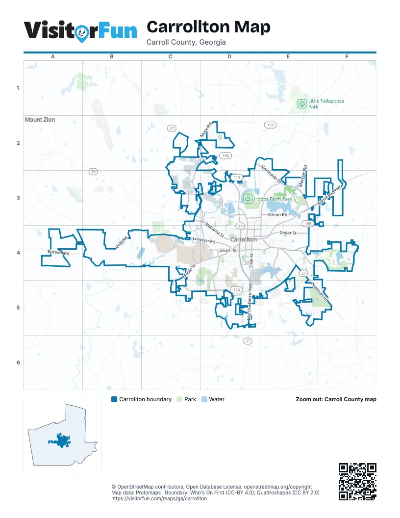
Street index of Carrollton
Each street on the sheet and the grid squares it crosses.
- Martha Berry HighwayC2, D2, D3, D4, D5
- Bankhead HighwayE3, F3, E4
- Northside DriveD2, E2, E3
- Newnan RoadE4, E5, F5
- Columbia DriveC2, D2, C3, D3
- Carrollton BypassC5, D5
- South Park StreetD4
- North Park StreetD3, D4
- Clinic AvenueD4
- Linda LaneD2
- Maple StreetC4, D4, C5
- Alabama StreetC3, D3, D4
- Newnan StreetD4, E4
- Stewart StreetE3, E4
- Cedar StreetD4, E4
- Old Bremen RoadD2, D3
- Lovvorn RoadC4, D4
- Kingsbridge RoadD3
- Old Newnan RoadE4
- Dixie StreetD4, D5
- Hays Mill RoadD4, D5
- West Georgia DriveC4, D4
- Rome StreetD3, D4
- Almon RoadE3
- South StreetD4
- Stripling Chapel RoadD5, E5, F5
- Beulah Church RoadC3, D3
- Blandenburg RoadE4, E5
- North White StreetD3, D4
- Austin AvenueD4, E4
- Brumbelow RoadD3, D4
- Bledsoe StreetE4
- Horsley Mill RoadE4, F4
- University DriveD4
- Spring StreetD4
- Shady Grove RoadE3
- Skinner RoadC3
- West White StreetD3, E3
- Brown StreetD4, E4
- Burwell RoadA4
- Bradley StreetD4
- Cottage Hill RoadD5
- Central RoadD5
- Lee StreetD4
- Williams StreetD3
- Bonner RoadC5
- Mote RoadD2
- North Lakeshore DriveE3
- Birkdale BoulevardE4, F4
- Stadium DriveC4
- Decoma DriveC3
- Cole RoadB4
- Burns RoadE3, E4
- Knollwood DriveD2
- Ballard Bridge RoadB4
- East Club DriveD4, C5, D5
- Shady Valley DriveE5, F5
- Victory CircleC4
- Cable Industrial WayD3
- Fairway DriveD4, C5, D5
- Briarwood DriveC4, C5
- Martin Luther King Junior StreetD3, D4
- Sunset BoulevardC4, D4
- Morgan RoadE2, E3
- Maple View DriveC4, C5
- College StreetD3, D4
- Longview StreetD4
- Adamson AvenueE4
- North Lake DriveE3
- Hidden Lakes DriveE5, F5
- West Club DriveC4, D4, C5
- South Ole Hickory TrailC4
- North Aycock StreetD4
- Douglas RoadB4
- North Cliff StreetD3, D4
- West AvenueD4, E4
- Willie North StreetD4
- Brookstone DriveE4, E5
- Believers BoulevardD3
- Forrest DriveC4
- Old Mill DriveD4, D5
- Ole Hickory Trail NorthC4
- Clarion DriveF4
- Fertilla StreetE4
- Foster StreetD4
- Burson AvenueD4
- Adamson Industrial BoulevardC3, D3
- Independence DriveE4
- Kramer StreetD4
- Carroll CircleE3
- Tom Reeves DriveD5
- Oak AvenueD4
- Ben Scott BoulevardD4, D5
- Stonecrest DriveE4, E5
- Mill pond CrossingE4
- Springwood DriveD2
- Fawn CircleD3
- West Lakeshore DriveE3
- Kilgore RoadE3, F3
- Plowshare RoadC3
- South Lakeshore DriveE3
- Clifton TerraceD4
- Sycamore DriveD5
- South Cottage Hill RoadD5
- Somerset PlaceE3
- Pinehurst WayF4
- Trojan DriveD4
- Elizabeth Village DriveD3
- Lakewood DriveE3
- Northwinds BoulevardD3
- Barnes DriveE4
- Carson PlaceD5
- Automation DriveC2
- Brandywine TrailC4
- Joshua MabryD3
- Chancery LaneD5
- North Cottage Hill RoadD5
- Champion DriveF4
- Brookwood DriveD2
- Brightwave BoulevardC2
- Wooded Glen RoadD3
- Park LaneD4
- Sheffield DriveE3
- Plantation WalkD5
- Strickland RoadE4
- Education DriveE4
- Southwire DriveD4, E4
- Habersham PlaceC4, C5
- Oak Mountain ParkwayE5
- Hampton WayE5
- Tanner StreetD4
- Belva StreetE4
- H M Fulbright DriveD4, D5
- Broad StreetD4
- Candlewood DriveD2
- Roop StreetD4, D5
- Harmon AvenueD4, E4
- Bennett CircleE4
- Cherry StreetD3, D4
- Morningside DriveE4
- Terry TerraceD3
- Zyzzx StreetD3
- Wilson DriveE3
- Corporate DriveE3
- Sequoia PointeD2
- Sims StreetD4, E4
- Alton Estes DriveE3
- Comly Rich DriveE3, E4
- Cedar Park WayE3, E4
- Farmington TraceE3
- Elder CircleD4
- Holmes DriveE3
- River DriveD3
- Mandeville AvenueE4
- Sunrise StripE4
- Wind Song CourtE4
- Natures TrailD4
- Centennial RoadD5
- Matthews AvenueD4
- Glen WayD3
- Wilson CircleE3
- Asher DriveE3
- Fourth StreetD3, D4
- Robert Hendrix DriveD3, D4
- Thurman StreetE3, E4
- Canterbury DriveE4
- Turnberry CircleF4
- Scenic view LaneF4
- Croft StreetD4
- Avenue CD4
- Lumpkin DriveE3
- South BoulevardD4
- Manor WayD5
- Avalon DriveD3
- Sandalwood DriveD2
- Front Campus DriveD4
- Ambulance DriveD4
- Alabama CircleD4
- Truitt RoadF4
- Tanglewood TrailE5, F5
- Katherine CourtC3
- Griffin DriveD4
- Carriage AlleyE4
- Arrowwood DriveD2
- Autumn Glen DriveE3
- Brock StreetD5
- Perry StreetE4
- Chapel RoadC4
- Jersey StreetD3, D4
- West Reese StreetD4
- Postal WayE3, E4
- Lynda CircleC4
- Hunter WayE3
- Old Mill CourtD4, D5
- Crestline WayD3
- Highland AvenueD4
- Valley DriveD3
- River Birch DriveF4
- Bagwell RoadC2, C3
- Valley CircleD3
- Enterprise AvenueD3
- Winson WayE4
- Providence DriveE3
- North Burson AvenueD4
- Watson StreetD4
- Carter StreetD4
- Maple CrossingC4
- Firestation DriveE3
- Greenway ParkwayD5
- Kyle WayD2
- Chaucer AvenueE4
- Remington CircleE3
- Teton AvenueD2
- Carroll StreetD4
- Wrenwood LaneD3, D4
- Oak Mountain TrailE4, E5
- Centerpoint CircleC4
- Pearl StreetD4
- Cunningham DriveD4
- Hammond StreetD3, D4
- John Wesley PlazaD4
- Frances PlaceD4
- Camilla DriveF4
- Industrial CourtC3, D3
- Molette StreetD4
- West Allison CircleD4, D5
- Danny DriveD3
- Innovation DriveC4
- Stoney Brook DriveE3
- George Harris RoadD2
- House CircleD3
- Lakeview DriveE3
- Old Airport RoadF3
- West Chandler StreetD4
- Avenue BD4
- Kingsbridge DriveD3
- Laney DriveE4
- First StreetD4
- Shady LaneC5
- South Garrett StreetD4, E4
- Valley Green DriveD3
- Victoria ViningF5
- Summer ChaseE4, E5
- Lake Carroll BoulevardE3
- Providence CourtE3
- Tuggle StreetD4
- Minden AvenueD4
- Bass StreetE4
- Beavers StreetD4
- Lisa LaneE3
- Turtle Point DriveE3
- National WayF4
- Melody DriveE4
- Martin DriveE3
- Apache PassD3
- Wedgewood DriveD4
- Coolwater TraceD5
- East Reese StreetD4
- Oil Park DriveD4
- Ashgate WayE3
- Lane DriveE4
- Magnolia StreetD3
- East Allison CircleD4, D5
- Commons BoulevardC4
- Seventh StreetD3, D4
- Sixth StreetD3
- Johnson AvenueD4
- Kingston CircleE4
- West Georgia Industrial AvenueC4, D4
- Dunwoody DriveC5
- Hickory ChaseC4
- Hillcrest RoadD4
- West Center StreetD4
- Howell RoadD4
- Bohannon RoadD2
- Westview WayD3
- Pine Knoll DriveE3, E4
- Aycock DriveC4, D4
- Crescent DriveE3
- Yellowstone DriveD2
- Bowen StreetD4
- Stonewall DriveC4
- Candy CircleE3
- Orange PassC3
- East Center StreetD4
- Fifth StreetD3, D4
- Banks DriveE3
- Hill DriveE4
- Saints AvenueD4
- Pine StreetD4
- Mill Stream CourtD4, D5
- Tabernacle DriveD5
- Development DriveD4
- Misty Hollow DriveF5
- Golf View CourtD4
- Sunset CourtC5
- Janice PlaceD4
- Cottage LaneD5
- Meadow RunE4
- Waverly WayE5
Places on the map
- 10 Federal Self Storage
- 3:16 Family Medicine Kid's Corner
- A Place of Refuge
- Adamson Square Amphitheater
- Advance Auto Parts
- Aldi
- Alpha Gamma Delta
- Barclay House of Carrollton
- Carrollton City Cemetery
- Carrollton City Hall
- Carrollton Crossroads
- Carrollton Elementary School
- Carrollton High School
- Carrollton Middle School
- Carrollton Post Office
- East Carrollton City Park
- East Carrollton Park Complex
- Hays Mill Park
- Hobbs Farm Park
- Johnson Lake
- King Street Cemetery
- Lake Carroll
- Lakeshore Park
- Longview Park
- Moore Lake
- Oak Mountain Golf Club
- Optimix Park
- Richards Lake
- SLM Recycling Incorporated
- Southwire Park
- Sunset Hills Country Club
- Sunset Hills Country Club Lake
- Tanner Health Park
- The Birches on Maple
- The Commons at The Birches
- University of West Georgia
- Walmart Supercenter
Next to Carrollton
- Mount Zion
© OpenStreetMap contributors, Open Database License, openstreetmap.org/copyright · Map data: Protomaps · Boundary: Who's On First (CC-BY 4.0); Quattroshapes (CC BY 2.0)















