

Georgia map
Clayton County map
About 297,703 people live here (Census Bureau, 2024 estimate). The sheet's index lists 35 streets; Jonesboro Road, Tara Boulevard and Forest Parkway cross the most grid squares. Things to do inside the boundary: Renaissance Atlanta Airport Gateway Hotel.
Open the map (PDF, US Letter)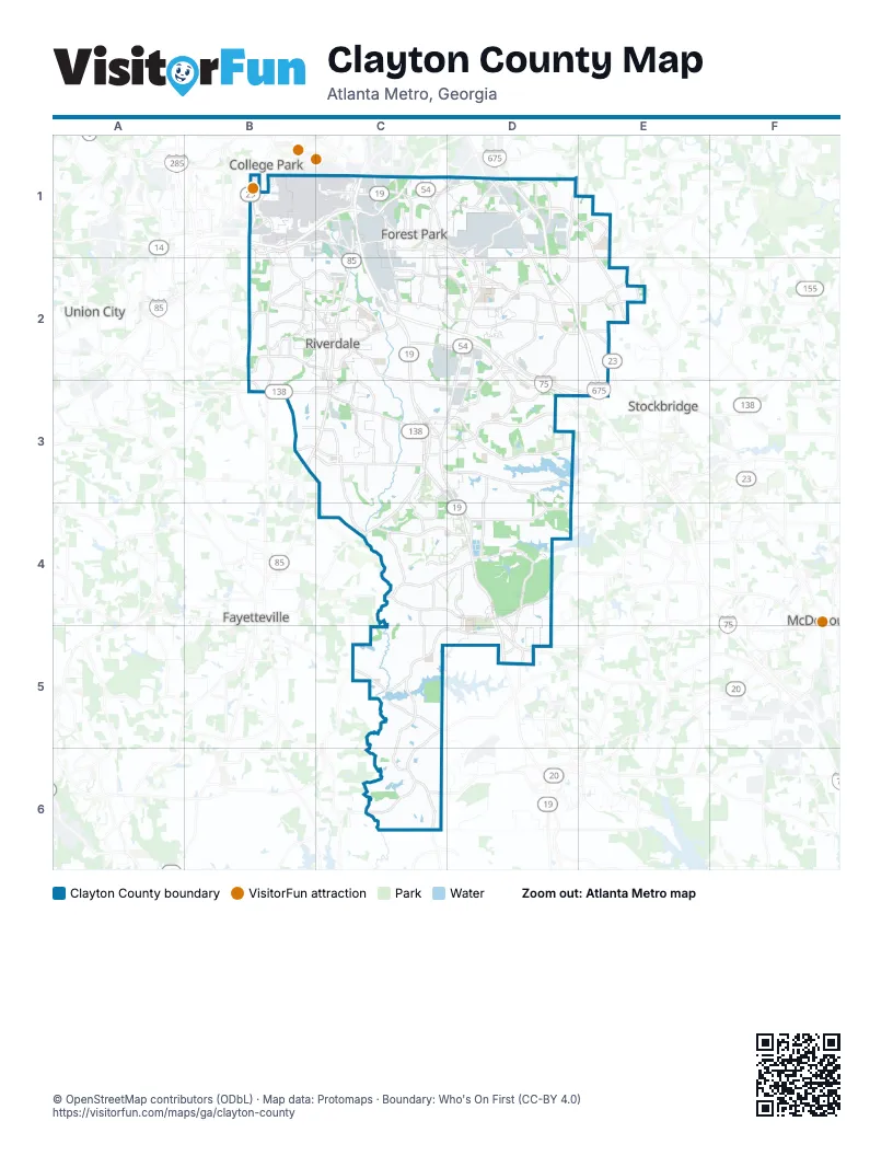
Street index of Clayton County
Each street on the sheet and the grid squares it crosses.
- Atlanta Bypass / The PerimeterB1, C1
- Camp Creek ParkwayB1
- Forest ParkwayB1, C1, D1, D2
- Main StreetB1, C2
- Riverdale RoadB1, B2, C2
- West Fayetteville RoadB1, B2, B3
- Airport Loop RoadC1
- Charles W Grant ParkwayC1
- Clark Howell HighwayC1
- International ParkwayC1
- Jonesboro RoadC1, D1, D2, C3, D3, D4
- Lake Mirror RoadC1
- Maynard H Jackson Junior BoulevardC1
- Old Dixie RoadC1, C2
- State Route 85C1, C2, B3, C3
- Thurman RoadC1, D1
- Anvil Block RoadD1, E1
- Macon HighwayD1, D2, E2
- Moreland AvenueD1, D2
- Moreland Avenue SoutheastD1
- Terrell Starr ParkwayD1, D2, E2, E3
- Church StreetC2
- Tara BoulevardC2, C3, D3, D4, D5
- Upper Riverdale RoadC2
- Valley Hill Road SoutheastC2
- Valley Hill Road SouthwestC2
- Fayetteville RoadC3, C4
- North AvenueC3
- North Main StreetC3
- North Mc Donough StreetC3
- Spring StreetC3
- Stockbridge RoadC3, D3
- Lake Spivey ParkwayD3, E3
- McDonough RoadC4, D4
- Hastings Bridge RoadD4, D5
Things to do on the Clayton County map
Places on the map
- Andover at Hawthorne
- Arrowhead Lake
- Bonanza
- Callaway Crossing Townhomes
- Camp Orr Lake
- Carol Woods
- Centerra Drive
- Charles R. Drew High School
- Chasleton Farm
- Clayton County
- Club Lake
- Concourse E
- Concourse T
- Conley
- Creekstone
- Drakes Lake
- Flemming Cove
- Forest Hills Memorial Gardens
- Forest Park
- Forest Park Quarry
- Fort Gillem
- Freeman Estates
- Gillem Logistic Center
- Hartsfield–Jackson Atlanta International Airport
- Hidden Creek
- Hunters Creek
- Irondale
- Jasmine Park
- JB Hunt Logistics
- Jonesboro
- Joy Lake
- Kade's Cove
- La Costa
- Lake City
- Lake Spivey
- Lakeside at Rivers Edge Plantation
- Lakeside Villas
- Lovejoy
- Lovejoy Crossing
Next to Clayton County
- College Park
- Fayetteville
- McDonough
- Stockbridge
- Union City
© OpenStreetMap contributors (ODbL) · Map data: Protomaps · Boundary: Who's On First (CC-BY 4.0)