

Georgia map
Sandy Springs map
About 105,505 people live here (Census Bureau, 2024 estimate). The sheet's index lists 300 streets; Roswell Road, Turner McDonald Parkway and Spalding Drive cross the most grid squares. Things to do inside the boundary: Chattahoochee River National Recreation Area.
Open the map (PDF, US Letter)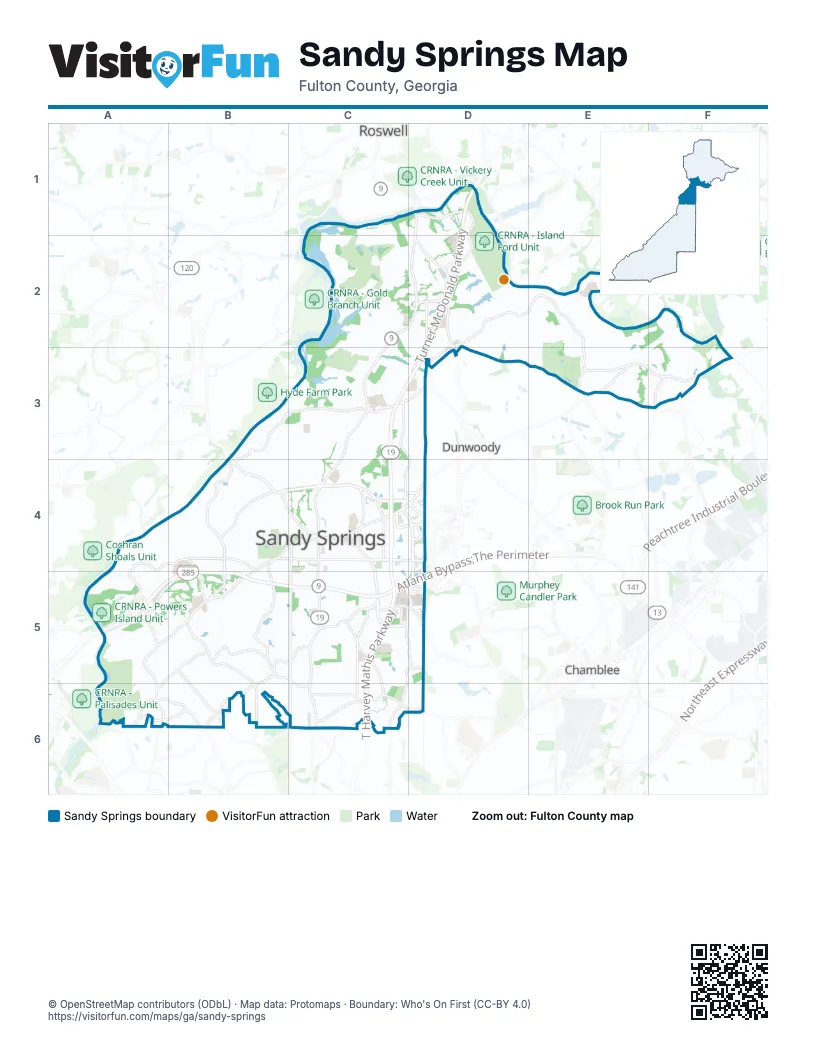
Street index of Sandy Springs
Each street on the sheet and the grid squares it crosses.
- Turner McDonald ParkwayD1, D2, C3, D3, C4, C5
- Atlanta Bypass / The PerimeterA5, B5, C5, D5
- T. Harvey Mathis ParkwayC5, C6
- Concourse Parkway NortheastC4, D4, C5, D5
- Roswell RoadD1, C2, D2, C3, C4, C5, C6
- Abernathy Road NortheastC4, D4
- Johnson Ferry Road NorthwestB4, C4
- Abernathy Road NorthwestB4, C4
- Roswell Road NortheastC6
- Holcomb Bridge RoadF2, F3
- Johnson Ferry Road SoutheastB4
- Spalding DriveD2, E2, C3, D3, E3, F3
- Mount Vernon HighwayB4, C4, D4, A5, B5
- Glenridge Drive NortheastC3, C4, C5
- Powers Ferry Road NorthwestA5, B5, B6
- Peachtree Dunwoody RoadD4, C5, D5, C6
- Northside Drive NorthwestA5, A6, B6
- Roberts DriveD1, D2, D3
- Peachtree Dunwoody Road NortheastC3, D3, C4, D4
- Dunwoody Club DriveD2, D3, E3
- Johnson Ferry Road NortheastC4, C5, D5
- Hammond Drive NortheastB4, C4, D4
- Mount Paran Road NorthwestB5, C5, B6
- Northridge RoadD2
- Glenridge ConnectorC5
- New Northside Drive NorthwestA5
- Perimeter Center WestD4
- Mount Vernon RoadE3
- Mount Paran Road NortheastC5
- Lake Hearn Drive NortheastD5
- Garmon Road NorthwestA6
- Glenridge ConnC5
- Riverside Drive NorthwestB3, C3, B4, B5
- Lake Forrest Drive NortheastC4, C5, C6
- Long Island Drive NorthwestB4, B5, C5
- Heards Ferry Road NorthwestA4, B4, A5
- Spalding Drive NortheastC3
- Windsor Parkway NortheastC6, D6
- Dunwoody PlaceD2
- High Point Road NortheastC5, C6
- Jett Ferry Road NortheastE2, F2, E3
- Dalrymple Road NortheastC3
- Northland Drive NortheastC5, C6
- River Valley Road NorthwestB4
- Jett Road NorthwestB5, B6
- Colquitt RoadD2, D3
- Crest Valley Drive NorthwestA5, B5, A6
- Londonberry Road NorthwestB5
- Crestline ParkwayC4, D4
- Hammond DriveC4
- Barfield Road NortheastC4
- Interstate North ParkwayA5
- Franklin Road NortheastC6
- Long Island Drive NortheastB4, C5, C6
- Harris Trail NorthwestA6
- Central Park DriveD4
- Davis Drive NorthwestA6, B6
- Happy Hollow RoadF3
- West Garmon Road NorthwestA6
- Central Parkway NortheastC4, D4
- Winters Chapel RoadF3
- North Park PlaceC4, D4
- Meridian Mark RoadC5
- Raider Drive NorthwestB4, B5
- Altmore AvenueC5, D5
- Heards Drive NorthwestB4, B5
- Evergreen Drive NortheastD5
- Central Parkway WestD4
- Mercedes-Benz DriveC4
- Altmore DriveC5, D5
- Dunwoody RoadD3
- Heards Road NorthwestB5
- Jett Ferry RoadE3
- Central Park WestD4
- West Wieuca Road NortheastC6
- South Mount Vernon HighwayB5
- Huntcliff TraceC1, C2
- Spring Creek LaneC2, C3
- Riverview Road NorthwestA5
- Morgan Falls RoadC3
- Brandon Mill Road NorthwestC3, B4, C4
- Nesbit Ferry RoadF2, F3
- River Chase Circle NorthwestA4
- Riverwood Drive NorthwestB4
- Glenlake Parkway NortheastC3, C4
- Hilderbrand Drive NortheastC4, C5
- Island Ford ParkwayD2
- Hightower TrailC2, D2
- Hunters Branch Drive NortheastD3
- Amberidge Trail NorthwestB4
- Trowbridge RoadC3
- Harbor Pointe ParkwayC2, C3
- Wright Road NortheastC4
- Brandon Hall DriveE2
- Grogans Ferry RoadC2
- Ball Mill Road NortheastE2, E3
- Cimmaron ParkwayC3
- Kayron Drive NortheastC4, C5
- Edgewater Drive NorthwestB4
- Glen Errol Road NorthwestB5
- Monterey ParkwayC3
- Innsbruck Drive NortheastD2
- Riveredge Parkway NorthwestA5
- Santa Fe ParkwayC3
- Sandy Springs Circle NortheastC4, C5
- Mount Vernon Parkway NorthwestB5
- Wing Mill RoadC2
- Cherry Tree Lane NortheastC4
- Black Water Trail NorthwestB4
- North River ParkwayD1
- Winterthur Drive NorthwestA4, A5
- North Mill RoadB3, C3, B4
- Dudley Lane NorthwestB6
- Forest Hills Drive NortheastC5
- Carriage Drive NortheastC4
- Dupree Drive NorthwestA5, B5
- Vernon Woods Drive NortheastC4
- Northgreen Drive NortheastC3
- South Trimble Road NortheastC5
- Hope RoadD1, D2
- Northridge ParkwayD2
- Elden Drive NortheastC5
- Tara Trail NorthwestB5
- Pitts RoadC2, D2, D3
- Riverhill Drive NorthwestB4
- Adair LaneC2, C3
- Rebel Trail NorthwestB5, B6
- Burdette Road NorthwestB5, C5
- North Island Drive NorthwestB5
- Twin Branch Road NortheastD3
- Forrest Lake Drive NorthwestB5, B6, C6
- Starlight Drive NortheastC6
- Habersham Waters RoadE2
- Glencourtney Drive NortheastC3
- Colewood Way NorthwestB4
- Glenairy Drive NortheastC4
- Old Powers Ferry Road NorthwestA5, B5
- Winding River Drive NortheastD1, D2
- Duncourtney Drive NortheastC3
- Weatherly Drive NorthwestB4
- Marsh Trail Circle NortheastC3
- Lexington DriveD1
- Bridgewood Valley Road NorthwestB4
- Aberdeen Drive NortheastC4
- Summit Springs DriveD2
- The Chace NortheastC4
- Lazy River LaneD2
- Brentwood WayD2, D3
- Huntcliff NortheastC2, D2
- Brigham DriveE3
- Claire Rose LaneB5
- Stewart Drive NortheastC5
- Mystic Drive NortheastC6
- Cedar RunD1, D2
- North Powers Ferry Road NorthwestB5
- Highbrook Drive NortheastC6
- Morgan Oak CircleC5
- Embassy Row NortheastC4
- Castleton Drive NorthwestC3, B4, C4
- Highland Park TrailD2
- Mabry Road NortheastC3
- River Shore Parkway NorthwestB4
- Glisten Northeast AvenueC3
- Gettysburg PlaceD2
- Pride PlaceD1, D2
- Willow Glen NortheastC5
- Northridge CrossingD2
- Wildercliff Drive NorthwestC3
- Stone Mill Trail NortheastC3, C4
- Pine Forest Road NortheastC6
- Riverside ParkwayB4
- River Court ParkwayB3, C3
- Masters Club DriveD2, E2
- Saddle Ridge DriveD2, D3
- Lake Island Drive NorthwestB5
- Island Ferry RoadD1, D2
- Tanglewood Trail NorthwestB6
- Hampton DriveC2, C3
- Errol Place NorthwestB5
- Carpenter Drive NortheastC5
- Dunwoody Springs Drive NortheastC4, D4
- Morgans Landing DriveC3
- Carroll Manor DriveD1
- River CircleE2, E3
- Dunhill Terrace NortheastC3
- Mountain Brook Lane NorthwestB4
- River Oak Place NorthwestB5
- Ball Mill PlaceD3
- Redbourne DriveE3
- Ball Creek WayD2
- Brookgreen Road NortheastC4, C5
- Allen Road NortheastC5
- Lake Placid Drive NortheastC5
- Summer CrossingD1
- Greenbrier Road NortheastC4, C5
- Bainbridge Drive NorthwestA5, B5
- Wembley CircleC3, D3
- Berkeley Run NortheastC5
- Ison Road NortheastC2
- Sandalwood DriveD1, D2
- Huntingdon TrailD2
- Riverside Trace NorthwestA4, B4
- Old Woodbine Road NortheastD6
- Northwood Drive NortheastC5
- Mitchell Road NorthwestB4, B5
- Highland Bluff NortheastC3
- Old Riverside Drive NorthwestB4
- Pine Lake Drive NorthwestB6, C6
- Cliftwood Drive NortheastC5
- Hunters Woods DriveE3
- Mountain Brook Way NorthwestB4
- Quiet Water LaneE2
- Chemin de Vie NortheastC5
- Tree Lodge ParkwayC3, D3
- Carol Lane NorthwestB5, B6
- Summer DriveC4, D4
- Hewlett RoadD2
- Landowne DriveE3, F3
- Williamson Drive NortheastC4
- Old Creek Trail NorthwestB4
- North Harbor Drive NorthwestB4
- Winding Creek Trail NorthwestB4
- Clay Drive NortheastD2, E2
- Glen Lake Drive NorthwestB5
- Summit Place DriveD2
- River Exchange DriveF3
- Stratford LaneD3
- Teesdale CourtE2
- Skyridge DriveE2
- Chevron WayD2, D3, E3
- Sunny Brook Lane NortheastC4
- Princeton Trace NortheastC3
- Calibre Springs Way NortheastC5
- East Powderhorn Road NortheastC6
- Glenforest Road NortheastC5
- The North Chace NortheastC4
- River Springs DriveB4
- East Conway Drive NorthwestB6
- Mark Trail NorthwestC3, C4
- Gables LaneC3, D3
- Willow Creek Drive NortheastC4
- Whitner Drive NorthwestB5
- Valemont DriveC2
- Indian Trail NorthwestA5, A6
- Waterford Place NortheastC5, C6
- Marlborough DriveE2
- Queen Anne CourtD1
- Merlendale Drive NorthwestB5, B6
- Misty Oaks DriveD2
- Devonwood Drive NortheastC3
- Breakwater RidgeB3, B4
- Hannover Park RoadC1, C2, D2
- Spalding Trail NortheastC3
- Prelude DriveC4
- River Run NortheastC1, C2
- The 5th Green NortheastC2
- River Overlook Drive NorthwestB4
- River North Parkway NorthwestB3
- Chevron DriveD2, E2, D3, E3
- Jett Forest Trail NorthwestA5, B5
- Greyfield LaneD1
- Cliffside Crossing NortheastC2
- North River DriveD1, D2
- Scott Valley Road NorthwestB4
- Winterthur Lane NorthwestA5
- Ferry Drive NortheastC4
- Northwold DriveD2
- Coles WayF2
- Cameron Ridge Drive NorthwestA5
- North Spalding Lake DriveE3, F3
- Spalding LaneF3
- Wyncourtney Drive NortheastC3
- Old College Way NortheastC3
- Berkley Ridge NortheastD2
- Cedar Hollow DriveD2
- Glencastle Drive NorthwestB5
- Garber Drive NortheastC4, C5
- Sandy Springs Place NortheastC4
- Tynecastle Drive NortheastD2
- Spruce Bluff DriveF2, F3
- Stella Drive NorthwestB6
- Bonnie Lane NortheastB4, C4
- Glenridge Point Parkway NortheastC5
- Maryeanna Drive NortheastC5
- Rivercliffe Drive NorthwestB4
- Kitty Hawk Drive NortheastC6
- Montevallo Drive NortheastC5
- Vernon Springs Trail NorthwestA5, B5
- Glenridge Stratford DriveC5
- Mount Vernon CircleD4
- Boylston Drive NortheastC4
- Old Dominion Drive NortheastE2
- Sherrell Drive NortheastC5
- Valley Hall DriveE2
- Glengate PlaceC4
- Wright Circle NortheastC4
- Underwood Drive NorthwestB4
- Ferry Crossing Landing NorthwestA4
- Greenland Road NortheastC5
- Nesbit Ferry LaneF3
Things to do on the Sandy Springs map
Places on the map
- Abernathy Greenway
- Arlington Memorial Park
- Atlanta Jewish Academy
- Berezney and Lee Lake
- Central Park Green Space
- Cherokee Town and Country Club (North)
- Cherokee Town and Country Club (South)
- CRNRA - Holcomb Bridge Unit
- CRNRA - Island Ford Unit
- CRNRA - Palisades Unit
- CRNRA - Powers Island Unit
- Croocked Creek Park
- Dunwoody Country Club
- Emory Saint Joseph's Hospital
- Fountain Oaks
- Heards Ferry Elementary School
- Holy Innocents' Episcopal School
- Ison Springs Elementary School
- JAS Worldwide
- Lake Forest Elementary School
- Lake Ridge 400
- North Springs Charter High School
- Northridge Lake
- Northside Hospital
- Orkin Lake
- Patronis Lake
- Peppertree Lake
- Power's Island
- Powers Ferry Landing
- Riverwood International Charter School
- Sandy Springs City Hall
- Sandy Springs Middle School
- Sandy Springs Racquet Center
- Sandy Springs Youth Sports
- Scottish Rite Hospital
- Steel Canyon Golf Club
- The Davis Academy
- The Prado
- The UPS Store
- The Weber School
Next to Sandy Springs
- Chamblee
- Doraville
- Dunwoody
- Roswell map
© OpenStreetMap contributors, Open Database License, openstreetmap.org/copyright · Map data: Protomaps · Boundary: Who's On First (CC-BY 4.0); Quattroshapes (CC BY 2.0)