

Georgia map
Walker County map
About 69,340 people live here (Census Bureau, 2024 estimate). The sheet's index lists 300 streets; Pocket Road, Sunset Drive and Cove Road cross the most grid squares. Things to do inside the boundary: Rock City.
Open the map (PDF, US Letter)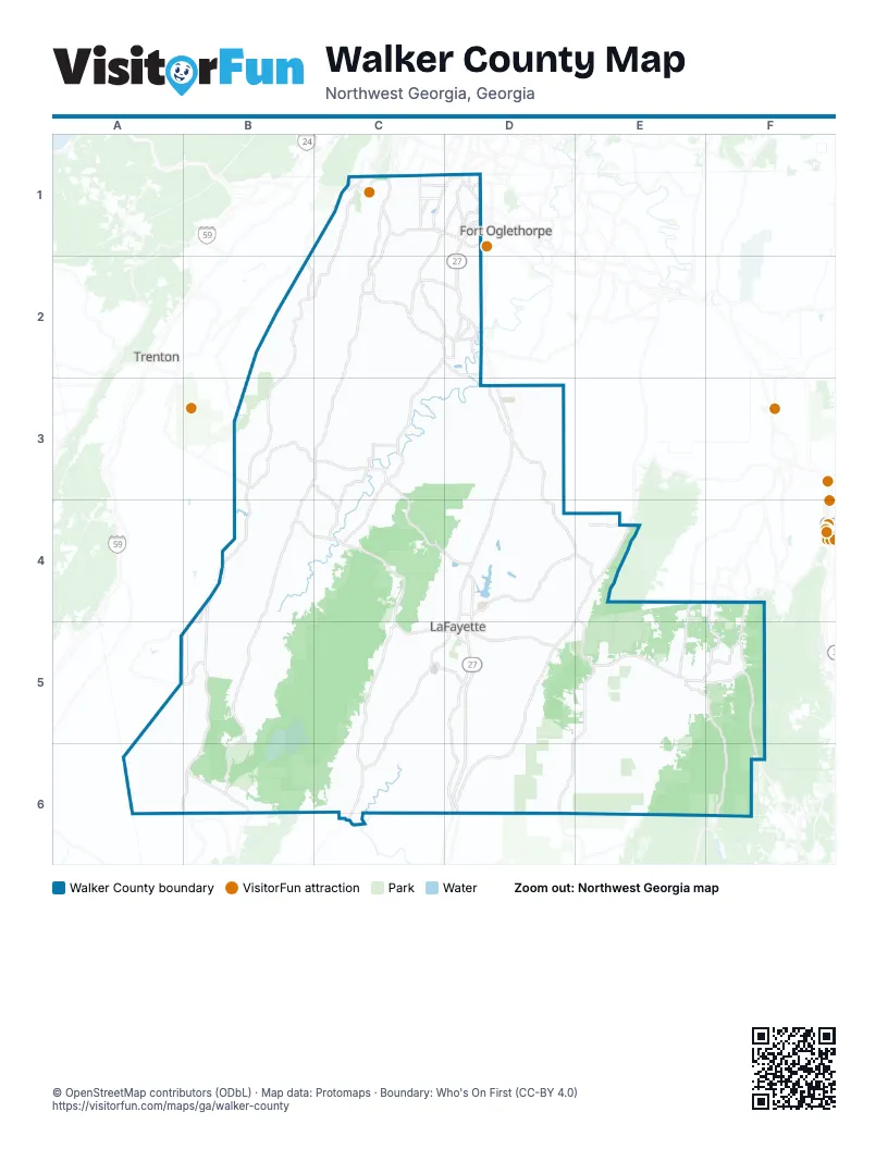
Street index of Walker County
Each street on the sheet and the grid squares it crosses.
- South Main StreetD5, D6
- Battlefield ParkwayC1, D1
- Lyle Jones ParkwayD4, D5
- North Main StreetD4, D5
- Chickamauga AvenueD1
- Lafayette RoadD2, E4
- Lafayette HighwayD2, D3
- Rossville BoulevardD1
- Rock Springs CreekD1
- Hinkle RoadB2, B3
- South Old Alabama HighwayE4, D5, D6
- Hog Jowl RoadB4, C4, B5
- Cove RoadC2, D2, C3, C4
- Trion HighwayD5, D6
- Lula Lake RoadC1, B2, C2, B6
- McFarland AvenueC1, D1
- Chattanooga Valley RoadC1, C2
- East Villanow StreetD5
- Lookout Mountain Scenic HighwayB3, C3, E5
- State Route 157B3, B4
- North Old Alabama HighwayE4
- West Schmitt RoadD1
- Yankee RoadA5, B5
- South Chattanooga StreetC5, D5
- Shattuck Industrial BoulevardC5, D5
- West Main StreetC5, D5
- Old Alabama HighwayD6
- Lee-Gordon Mill RoadD2
- Red Riding Hood TrailC1
- Lee AvenueC1, C2, D2
- Scenic HighwayC1
- Broomtown RoadC5
- Lakeview DriveD1, D4
- Gordon StreetC2, D2
- Hasty LaneC3
- Mc Farland RoadC1
- North Industrial LoopC5
- Five Points RoadC2, D2
- Post RoadD1
- Spur RoadD6
- St Elmo AvenueC1
- Cane Creek BridgeD6
- Old Alabama RoadE4
- Ochs Highway ExtensionC1
- West Cove RoadB4, B5
- Pocket RoadB4, C4, E5, F5, F6
- West Armuchee RoadD5, E5, D6
- Chamberlain RoadC5, C6
- Kensington RoadC3, C4
- Round Pond RoadD4, E4
- Chickamauga RoadC2
- Happy Valley RoadC1
- Mission Ridge RoadC1, C2
- Dougherty Gap RoadB5, B6
- Villanow Mill Creek RoadE5, F5
- Lower Mill Creek RoadF4, F5
- Clement RoadF4, F5
- Johnson RoadC2, D2
- Park City RoadD1
- North Long Hollow RoadC2, D2
- Hogan RoadC1, D1
- Old Chattanooga Valley RoadC2
- Old Lafayette RoadD3
- Wilder RoadD2
- High RoadA6, B6
- Osburn RoadD2
- Wilson RoadC1
- Prospect RoadB3, C3, C4
- County Line RoadE4
- Old Highway 27D3
- Nick A Jack LaneC2
- Lee Clarkson RoadD2
- Old State Highway 157B4, B5
- Joe Robertson RoadE4, F4
- James StreetC1
- Crittenden AvenueD2
- Bill Scott RoadE5, F5
- Maple StreetC1, D1, D5
- Euclid AvenueC2, D2
- South Crest RoadD1, D5
- Dewberry RoadD1
- Glentana StreetC1
- Warthen StreetD4
- Red Belt RoadD2
- West 10th StreetD2
- Tennessee AvenueC1, D1
- Lee-Gordon Mill CircleD2
- West Cloud Springs RoadD1
- Farming Rock RoadD3
- Rock Spring DriveD3
- Scmitt RoadD1
- Rocky LaneB5, C5, B6
- Straight Gut RoadD3, D4
- Forest Service Road 252D5, D6
- East Armuchee RoadE5, E6
- North Marble Top RoadC2, C3
- South Dicks Creek RoadE5, E6
- East Broomtown RoadC5, C6
- Ringgold RoadD3, D4
- Manning Mill RoadE5, E6
- Bronco RoadC5
- Cantrell RoadE5, E6
- Corinth RoadD5
- Garretts Chapel RoadC2, C3
- Halls Valley RoadD6
- Cordell RoadD4, D5
- Smith Gap RoadD5, E5
- Boss RoadC3
- Peavine RoadD3
- Lake Howard RoadD4
- Old Bethel RoadC3, D3
- Shinbone Valley RoadC5, C6
- Flarity RoadA6, B6
- Old Mineral Springs RoadC4, D4
- Foster Mill DriveC5, D5
- Harrisburg RoadB6, C6
- Nick-A Jack RoadB2, C2
- Glass Mill RoadC2, C3, D3
- Salem RoadC1
- Concord RoadE5
- Ridgeway RoadC6
- Kemp RoadD5
- Lytle RoadC1, C2, D2
- South Long Hollow RoadC6
- Dripping Springs RoadC4
- Kay Conley RoadD3
- Dunwoody RoadD4, E4, D5
- Shinbone Ridge RoadC4
- Vittetoe RoadC2, D2
- Lee School RoadD5, D6
- Burnt Mill RoadC1
- Estelle Mines RoadC4
- Back Valley RoadB3, B6
- Tatum RoadB4
- Monroe Green RoadD5, D6
- Dry Valley RoadC1, C2
- Cooper RoadD3, E4
- Oakton RoadC6, D6
- Griff Johnson RoadA5, A6
- Durham RoadB2, D2
- South Burnt Mill RoadC2, C5
- Bowater RoadF6
- Magnolia StreetD1, C5, D5
- Fricks Gap RoadB3, B4
- Long Hollow RoadD3
- Center Grove RoadD3
- Crow Gap RoadB4, B5
- Reo RoadE4
- Powder Springs CircleC2
- South Mission Ridge DriveC1, D1
- Coffman Springs RoadD5
- Wood Nymph TrailC1
- Furnace Creek RoadF5
- Old Grand Center RoadC2
- Andrews LaneB4
- Stanfield DriveC5
- Veeler RoadD3, D4
- Vulcan RoadB2
- Ridgeland RoadC1, C2
- Huffman RoadE4
- North Dick Creek RoadE4, E5
- Baker & Hearn CircleC3
- Bonds RoadC3
- Rogers RoadD1, C2
- Grand Center RoadC2
- Walnut Grove RoadC5, D5, C6
- Scoggins LaneD6, E6
- Akins RoadB4, C4
- Beaumont RoadD3
- Camp RoadC3, C4
- Forest Service Road 219E4, E5
- Brock RoadC3, D3
- Blue Hole RoadC4, C5
- McIntire RoadD4, E4
- York RoadD4, D5
- East Reed RoadD4
- Mill Wee Hollow RoadC2
- North Chattanooga StreetC4, D4, D5
- Moon Lake RoadA6, B6
- Vittetoe Chickamauga RoadD2
- West 12th StreetC2
- Rock Creek RoadC1, B2
- Lee Mason RoadD4, D5
- Lofton LaneD3
- Childers Hollow RoadC2
- Shipp RoadD4, E4
- Ramey RoadD6
- Schmitt RoadC2
- Vulcan DriveB2
- Arnold RoadD3
- Old Dalton HighwayD4
- East Guild RoadC5, D5
- Brotherton LaneC3
- Bicentennial TrailD3
- Ascalon RoadB3
- South Marble Top RoadC3
- Bill Orr RoadD6
- Halls Mill RoadC3, C4
- Taylor Broome RoadC3
- Mount Olive RoadB2
- South Cedar LaneB5
- Wheeler RoadD4
- Friendship RoadC3
- Clyde Bird RoadD4
- Crest DriveC2, D3, D5
- Tower RoadB2
- North Jenkins RoadD1, D2
- McConnell CrossingC6
- Probasco Street NorthD4
- Martindale RoadC6
- Fleetwood DriveC1, D1
- Glass RoadD3, D4
- Lanier DriveE6
- Tanglewood DriveD4
- Old Villanow RoadD5, E5
- Van Dell DriveE4
- Kaufman RoadD4, E4
- Flintstone RoadC1
- Shook RoadB3, C3
- Captain Wood RoadB4, B5
- West Reed RoadD4
- Bell RoadC2, D3
- Jones LaneC3
- Harp Switch RoadC2
- Thornton HollowD5
- Williams LaneC1, D1, C2
- Rainbow DriveC1, C2
- Stoker RoadB6
- Cannon RoadD4
- 1st StreetC1, D1, D4, D5
- Shahan LaneE5, F5
- East Warren RoadD4
- Ponder Creek RoadE5
- South Jenkins RoadD2
- Lisbon RoadC3
- Alpine DriveD1, D5
- Guy Williams RoadD3
- Kendrick's Switch RoadC3
- Bolcar BoulevardC6
- Longwood StreetD2
- Ridge RoadA5, B5, C5
- Mountain View CircleC1, C2
- Cook RoadD4, D5
- Homer Cagle RoadC5
- North Duke StreetD4, D5
- Marble Top RoadC2
- Glenn StreetD1, C5
- Crestridge DriveC2
- Worthington Gap RoadD3
- Richardson RoadE6
- Roy Bird RoadD3
- McCarter RoadD4
- Greenbush RoadD5
- Jones RoadD3
- Hillsdale RoadC4, C5
- Goodson CircleD3
- Diamond CircleD4
- Sunset DriveC1, D1, C2, D4, D5
- Daugherty StreetC5, D5
- Dogwood CircleD3, D4
- Hankins RoadD3
- Valley Head Church RoadC4
- Hurtt RoadC2, D2
- Wood Station RoadD3
- Lee Wilson RoadC6, D6
- Camp Adahi RoadB6
- Bowen LaneC3
- Park StreetD2, D4
- Joseph TrailB4
- Eagle Cliff DriveC2
- Martin Clement RoadC3
- Lail RoadC2
- Washington RoadD1
- Abney Hollow RoadD4, D5
- West Garden Farm RoadC2
- Deerfield RoadC4
- Adams LaneC2, D2
- Access Road / Old RR GradeC2
- Prospect CircleC3, C4
- Simmons Tawzer RoadC2
- Newt Johnson RoadC3, C4
- Meadow LaneB5
- Canyon RidgeB4
- Meadow DriveC3, D3
- Patten RoadC1
- Harold Stevens RoadB3, B4
- Patten PlaceC1
- West Lewis StreetC2
- Napier Chapel RoadC6
- North Moore RoadB3
- Valley View Ranch RoadB6
- Sourwood LaneB4
- Gordon Pond RoadD4
- Ken Visage LaneD4
- Phillips Hollow RoadC3
- East Garden Farm RoadC2, D2
- Southern RoadC3, C4
- West North Main StreetD4
- Williams RoadC2
- Buckner RoadC2
Things to do on the Walker County map
Places on the map
- 4 Tons
- Abney Lake
- Barwick Lafayette Airport
- Barwick Reservoir
- Camp Adahi Lake
- Chalkeye Loop
- Chattanooga Valley
- Chickamauga
- Chickamauga Cemetery
- Chickamauga City Hall
- Clements Pond
- Crawfish Spring Lake
- Crest Lawn Memorial Park
- Crockford-Pigeon Mountain Wildlife Management Area
- Dickson Lake
- Dow Chemicals (former)
- Fairview
- Gordon Lake
- Howard Lake
- Kettle Bottom
- Krystal Lake
- LaFayette
- LaFayette Cemetery
- LaFayette City Resevoir
- LaFayette Golf Course
- LaFayette High School
- Lloyds Lake
- Lookout Mountain
- Lookout Mountain Golf Club
- Marion 21
- Mountain Cove Lake
- Rock City Gardens
- Rock Spring
- Rossville
- Scott Lake
- Shields Lake
- Smith Green East Lake
- Walker County Quarry (#038)
- Walker State Prison
- Williams Lake
Next to Walker County
- Fort Oglethorpe
- Trenton
© OpenStreetMap contributors, Open Database License, openstreetmap.org/copyright · Map data: Protomaps · Boundary: Who's On First (CC-BY 4.0); Quattroshapes (CC BY 2.0)