

Idaho map
Blackfoot map
About 13,224 people live here (Census Bureau, 2024 estimate). The sheet's index lists 258 streets; Veterans Memorial Highway, North State Street and West Bridge Street cross the most grid squares. Things to do inside the boundary: Idaho Potato Museum.
Open the map (PDF, US Letter)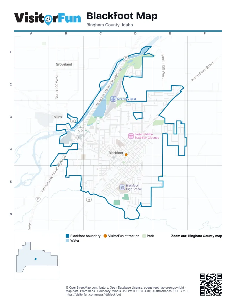
Street index of Blackfoot
Each street on the sheet and the grid squares it crosses.
- Bergeson DriveD1, D2
- Mulligan DriveD1
- Teeples DriveD1, D2
- Veterans Memorial HighwayD1, C2, D2, B3, C3, B4
- Amaya CircleD2
- chaparro LaneD2, D3
- James StreetD2, E2
- justa CircleD2
- Kerr LaneD2
- Konishi StreetD2
- North Airport RoadD2, D3
- North von elm DriveD2
- Palmer DriveD2
- South Von Elm DriveD2
- Trevino DriveD2
- Von elm DriveD2
- West 100 NorthD2, E2
- Clover StreetE2, E3
- Emerald AvenueE2
- Gardner DriveE2
- Hunters LoopE2
- Neff CircleE2
- North 150 WestE2
- North State StreetE2, D3, E3, D4
- Northland AvenueE2
- Robert StreetE2
- Rose RoadE2, E3
- Roy AvenueE2
- Ward DriveE2
- Windsor CourtE2, E3
- Bergener BoulevardB3, C3, C4
- West Bridge StreetB3, B4, C4, D4
- West Collins RoadB3
- West State Highway 39B3
- Archer StreetC3, C4
- Cedar StreetC3, C4
- Connie DriveC3
- East Airport RoadC3, D3, E3
- Harbor DriveC3, D3
- Hoff DriveC3
- Jensen Grove Boat RampC3
- Jensen Grove DriveC3
- Lakeside DriveC3
- Lilac StreetC3, C4
- Nicole DriveC3
- North Meridian StreetC3, C4
- Parkway DriveC3, C4
- Pearl DriveC3
- Wildrose LaneC3
- Wooton WayC3, D3
- Airport RoadD3, D4
- Alexander BoulevardD3, E3
- Apple StreetD3
- Arave LaneD3
- Borreson StreetD3
- Carol DriveD3
- Cunningham LaneD3
- Eagle WayD3
- East Dove CircleD3
- East Falcon CircleD3
- East Quail CircleD3
- Gwen LoopD3
- Highland DriveD3, D4
- Hillridge AvenueD3
- Jones StreetD3
- Lemon StreetD3
- Moses StreetD3
- Ogden StreetD3
- Peach StreetD3
- Peterson BoulevardD3
- Royal StreetD3
- Sparling StreetD3
- Statefair DriveD3
- Tana DriveD3
- West Dove CircleD3
- West Falcon CircleD3
- West Quail CircleD3
- Abbie RoadE3
- Arbon DriveE3
- Blueberry TrailE3
- Casandra WayE3
- Centennial StreetE3
- Charlynn WayE3, E4
- Country AvenueE3, E4
- Daniele WayE3, E4
- Grove StreetE3
- Meadow WayE3
- Meggan WayE3
- Parker AvenueE3, E4
- Rich LaneE3, D4, E4
- Sadie LaneE3
- Sage CircleE3
- Willow DriveE3, E4
- Clark DriveB4
- Doud StreetB4, C4
- Frontage RoadB4
- Gary DriveB4
- Hanhauser CircleB4
- Janet StreetB4
- Lansing StreetB4, B5
- McAdoo StreetB4, C4, C5
- Shirley StreetB4
- Wandell StreetB4, B5
- West Center StreetB4, C4
- Wilson AvenueB4, C4
- Camas StreetC4, C5
- Cone StreetC4
- Coral AvenueC4
- Dobel StreetC4
- Don's WayC4
- Dortha StreetC4
- Elaine StreetC4
- Elm StreetC4
- Grant StreetC4
- Hall StreetC4
- Johnson StreetC4, C5
- Juniper StreetC4
- Kirby StreetC4
- Lena LaneC4
- Lincoln StreetC4
- Louella StreetC4
- Luther WayC4
- Market StreetC4
- North Maple StreetC4, D4
- North Oak StreetC4, D4
- North Pine StreetC4
- North Spruce StreetC4
- Parsons StreetC4, D4
- Pine StreetC4
- Poplar StreetC4, D4
- Private DriveC4
- Rice StreetC4, C5
- Robbins StreetC4
- Sexton streetC4
- Sherman StreetC4, C5
- South Alder StreetC4
- South Ash StreetC4, D4, C5
- South Birch StreetC4
- South Broadway StreetC4, D4, C5
- South Maple StreetC4, C5
- South Meridian StreetC4, C5
- South Oak StreetC4
- South Spruce StreetC4
- Southwest Main StreetC4, D4
- West Judicial StreetC4, D4
- West Pacific StreetC4, D4
- West Sexton StreetC4
- Allen StreetD4
- Bingham StreetD4, D5
- East Alice StreetD4
- East Bridge StreetD4, D5
- East Court StreetD4, D5
- East Francis StreetD4
- East Idaho StreetD4
- East Judicial StreetD4, D5
- East Pacific StreetD4
- East Washington StreetD4
- Gifford StreetD4
- Hawley StreetD4
- Jackson StreetD4
- Jefferson StreetD4
- Lavon StreetD4
- McDougal StreetD4
- Monroe StreetD4
- North Adams AvenueD4, D5
- North Ash StreetD4
- North Broadway StreetD4
- North Fisher StreetD4, D5
- North Shilling AvenueD4
- North Stout AvenueD4
- North University AvenueD4
- Northeast Main StreetD4
- Northwest Main StreetD4
- Park StreetD4
- Pendlebury LaneD4, D5, D6
- Poole StreetD4, E4
- South Shilling AvenueD4, C5, D5
- South Stout AvenueD4, C5, D5
- South University AvenueD4, C5, D5
- Southeast Main StreetD4, C5
- West 50 SouthD4, E4
- West Alice StreetD4
- West Francis StreetD4
- West Idaho StreetD4
- West Washington StreetD4
- East Harmony DriveE4
- Fullmer LaneE4
- Harmony DriveE4
- Merkley LaneE4
- West Harmony DriveE4
- West Rich LaneE4
- Buckboard TrailB5
- Chuckwagon PlaceB5
- Riverton RoadB5, C5
- Surrey LaneB5, C5
- Travois CircleB5
- Wagon Wheel DriveB5, C5
- Amhurst StreetC5
- Clifford StreetC5, C6
- Collins StreetC5, D5
- Conestoga CircleC5
- Conestoga WayC5
- Curtis StreetC5, D5
- Dennis StreetC5
- Dewey StreetC5, D5
- East Walker StreetC5, D5
- Fisher AvenueC5
- Golden StreetC5
- Jewell StreetC5
- Kirk StreetC5
- Knox StreetC5
- Last StreetC5
- Minor StreetC5
- Opal StreetC5
- Paul StreetC5
- Rich StreetC5
- Robertson StreetC5
- Ruby StreetC5
- Smith StreetC5, D5
- South Fisher StreetC5, D5
- South StreetC5, D5
- Sumac StreetC5
- Sunset AvenueC5
- Surrey CourtC5
- Topaz StreetC5
- Vernon StreetC5
- West Walker StreetC5
- Willis StreetC5, D5
- Benton DriveD5
- Cromwell LaneD5, E5
- Goodwin DriveD5
- Harris LoopD5
- Henderson DriveD5
- Hillview DriveD5
- Horrocks DriveD5
- Lawrence LaneD5, E5
- Lynn DriveD5, D6
- Mount Putnam DriveD5, D6
- North Cleveland AvenueD5
- Packer DriveD5
- Plaza DriveD5
- Rebecca DriveD5, D6
- Rodgers AvenueD5
- Sonny StreetD5
- South Adams AvenueD5
- South Cleveland AvenueD5
- Teton RoadD5
- Valley DriveD5
- York CircleD5
- York DriveD5, D6
- Sevana LoopE5
- Berrett DriveD6
- Christensen DriveD6
- Hepworth LaneD6
- McKinley StreetD6
- Reed StreetD6
- Ruthann DriveD6
- York RoadD6
Things to do on the Blackfoot map
Places on the map
- Airport Park
- Best Western Blackfoot Inn
- Bingham Memorial Hospital
- Blackfoot Christian Fellowship
- Blackfoot Golf Course
- Blackfoot High School
- Blackfoot Library
- Blackfoot Movie Mill
- Blackfoot RV Park
- Blackfoot Swimming Pool
- Chevron
- Costa Vida
- Courthouse Square
- Eastern Idaho State Fair Grounds
- El Mirador
- Grove City Cemetery
- I T Stoddard Elementary School
- Idaho Doctors' Hospital
- Idaho Potato Museum
- Jehovah's Witnesses
- Jensen Grove Park
- Jensens Grove Lake
- Kesler's
- KeyBank
- Les Schwab Tire Center
- Lighthouse Assembly of God
- McCarley Field
- McDonald's
- Pony Express
- Ridley's Family Markets
- Riverside Plaza
- Rupe's
- Stalker Elementary School
- State Hospital South
- Stoors Market
- Super 8 by Wyndham Blackfoot
- Taco Bell
- The Church of Jesus Christ of Latter-day Saints
- The UPS Store
- Walmart Supercenter
Next to Blackfoot
- Collins
- Groveland
© OpenStreetMap contributors, Open Database License, openstreetmap.org/copyright · Map data: Protomaps · Boundary: Who's On First (CC-BY 4.0); Quattroshapes (CC BY 2.0)















