

Idaho map
Coeur d'Alene map
About 57,355 people live here (Census Bureau, 2024 estimate). The sheet's index lists 300 streets; North Government Way, North Ramsey Road and North 4th Street cross the most grid squares. Things to do inside the boundary: Lake Coeur d'Alene Cruises, Boardwalk Marina and Silver Lake Mall.
Open the map (PDF, US Letter)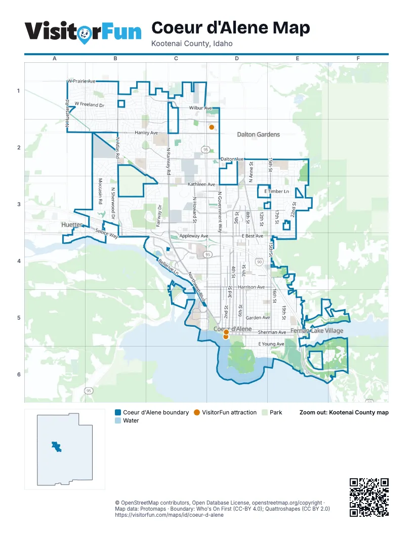
Street index of Coeur d'Alene
Each street on the sheet and the grid squares it crosses.
- North Government WayD1, D2, D3, D4, D5
- North Ramsey RoadC1, C2, C3, C4
- North 4th StreetD2, D3, D4, D5
- Northwest BoulevardC4, C5, D5
- West Seltice WayB3, B4, C4
- East Lakeside AvenueD5, E5
- West Appleway AvenueC3, C4, D4
- Sherman AvenueD5, E5
- West Prairie AvenueA1, B1, C1
- North Lincoln WayD4, D5
- East Appleway AvenueD4
- East Seltice WayB3
- East Sherman AvenueE5
- US 95D4
- North 15th StreetE2, E3, E4, E5
- North Atlas RoadB1, B2, B3, B4
- West Kathleen AvenueB2, C2, C3, D3
- North 3rd StreetD4, D5
- East Best AvenueD4, E4
- East Harrison AvenueD4, E4
- North Huetter RoadA1, A2
- East Hazel AvenueD4, E4
- East Kathleen AvenueD3
- West Neider AvenueC3, D3
- East Margaret AvenueD3, E3
- North 23rd StreetE5
- West Harrison AvenueC4, D4
- East Neider AvenueD3
- West Hanley AvenueA2, B2, C2, D2
- North 7th StreetD3, D4, D5
- North 5th StreetD3, D4, D5
- North 6th StreetD3, D4, D5
- North 2nd StreetD3, D4, D5
- West Wilbur AvenueB1, C1, D1
- North 8th StreetD3, D4, D5
- East Dalton AvenueD2, E2
- West Dalton AvenueB2, C2, D2
- North Honeysuckle DriveD3, D4
- East Front AvenueD5, E5
- West Ironwood DriveC4, D4
- East Coeur d'Alene Lake DriveE5, E6
- West Canfield AvenueC1, C2, D2
- West Lacrosse AvenueC4, D4
- East Lunceford LaneD3, E3
- North Howard StreetC3, C4
- West Riverstone DriveC4
- North 1st StreetD4, D5
- East Fernan Lake RoadE5, F5
- East Potlatch Hill RoadE6
- West Hubbard AvenueC5, D5
- West Marie AvenueC3
- West River AvenueC5, D5
- West Garden AvenueC5, D5
- North College DriveC5
- West Bosanko AvenueC3, D3
- North Park DriveC5, D5
- North Lakewood DriveC4
- West Sunset AvenueC3, D3
- South 8th StreetD5, D6
- West Golf Course RoadC3
- West Lakeshore DriveC5, D5
- East Maplewood AvenueA4
- West Lakewood DriveC4
- South 3rd StreetD5
- South 4th StreetD5
- South 5th StreetD5
- South 6th StreetD5
- South 7th StreetD5
- East Rosenberry DriveC5
- East Hanley AvenueD2
- East Wilbur AvenueD1
- Garden AvenueD5
- North 9th StreetD3, D4, D5
- North 12th StreetD3, D4, D5
- West Fairway DriveB3, C3
- North 13th StreetD3, D4, D5
- North 11th StreetD3, D4, D5
- North Courcelles ParkwayB1, C1, B2, C2
- East Coeur d'Alene AvenueD5, E5
- North 10th StreetD3, D4, D5
- North 17th StreetE2, E3, E4, E5
- East Sky Harbor DriveE6, F6
- North 19th StreetE3, E5
- North 16th StreetE2, E3, E4, E5
- North 14th StreetD3, E4, E5
- East Garden AvenueD5, E5
- Industrial LoopB2
- East Mullan AvenueD5, E5
- East Montana AvenueD5, E5
- North Carrington LaneB1, B2
- West Pinegrove DriveC1, C2
- East Timber LaneD3, E3
- East Birch AvenueD5, E5
- East Pennsylvania AvenueD5, E5
- East Fernan Hill RoadE5, F5
- East Wallace AvenueD5, E5
- West Nez Perce RoadB3
- East Indiana AvenueD5, E5
- North 22nd StreetE3, E5
- North Cornwall StreetB1, B2
- East Foster AvenueD5, E5
- North Downing LaneA1, A2, B2
- East Thomas LaneE3
- North Mineral DriveC1, C2
- East Spokane AvenueD4, E4
- East Hastings AvenueD5, E5
- East Walnut AvenueD4, E4
- North Sherwood DriveB3
- Fred Meyer Coeur d'AleneC3
- East Saint Maries AvenueD5, E5
- East Gilbert AvenueD3, E3
- East Locust AvenueD4, E4
- Moccasin RoadB2, B3
- West Princetown LaneA1, B1
- North Madellaine DriveB1, B2
- North Belmont RoadB3
- Buckskin RoadB3
- East Young AvenueD5, E5
- North Fruitland LaneC3, C4
- West Davidson StreetC4, D4
- West Emma AvenueC4, D4
- East Davis AvenueD3, E3
- East Spruce AvenueD4
- East Hoffman AvenueD2, E2
- East Hattie AvenueD4, E4
- East Maple AvenueD5, E5
- East Thomas Hill DriveE3
- West Mill AvenueC4, D4
- West Freeland DriveA1, B1
- East Fernan Terrace DriveE5, F5
- East Homestead AvenueD4, E4
- East Elm AvenueD5, E5
- North 21st StreetE3, E5
- North Harcourt DriveB2, C2
- West Shoreview LaneA4, B4
- East Shadduck LaneE3
- East Boyd AvenueD5, E5
- North Schreiber WayC3
- North Talon LaneB1, B2
- North Player DriveC2, C3
- Bellerive LaneC4
- East McFarland AvenueD4, E4
- West Canyon DriveB3, C3
- North A StreetD4, D5
- West Timberlake LoopB1, C1
- West Thorndale LoopB1
- West Westminster AvenueC2
- West Lotze LoopB1
- West Homeward Bound BoulevardA1, B1
- West Vista DriveC3
- North Joanna DriveB1
- East Crawford AvenueD3
- North Mount Carrol StreetD2, D3
- West Newbrook DriveB1
- West Wilbur DriveB1
- West Long Meadow DriveA1, B1
- Jonshawk DriveB1, B2
- South Floating Green DriveE6
- West Idlewild LoopB3
- Crestline DriveE4, E5
- North 18th StreetE3, E5
- North Coeur Terre BoulevardA1, A2
- North Anne StreetD2, D3
- North Huntercrest DriveE2, E3
- West Appaloosa RoadB3
- Lodgepole RoadB3
- West Moselle DriveB1, C1
- West Loxton LoopB1
- North Julia StreetC3, C4
- North Broken Arrow RoadB3
- North B StreetD4, D5
- East Borah AvenueD4, E4
- West Lennox LoopB1
- East Nettleton Gulch RoadE3
- Saint Michelle DriveB2
- South 10th StreetD5, D6
- West Arrowhead RoadB3
- North Girard CircleC1
- East Violet AvenueD3, E3
- East Poplar AvenueD4
- North C StreetD4, D5
- West Dumont DriveB2
- East Bancroft AvenueD5, E5
- North 10th PlaceD3, D4
- East Pinegrove DriveC2
- North la Rochelle DriveB2
- North Roche DriveB1, C1
- Elderberry CircleD3, E3
- West Sorbonne DriveB2
- East Stiner AvenueD3, E3
- South 11th StreetD5, D6
- South 12th StreetD5, D6
- East Skyline DriveE4
- West Calzado DriveB2
- West Pineridge DriveB3
- West Wirth DriveA1, B1
- North Wheatfield DriveC1
- East Haycraft AvenueD3, E3
- East Annie AvenueD4
- Versailles DriveB2
- East Mountain Vista DriveE2, E3
- Holmes RoadB2, B3
- North Victorian DriveE5, F5
- John's LoopC4
- North Martha LoopE2
- North Windy Pines StreetC1, C2
- West Park AvenueC2, D2
- North Fairborne LaneA1
- West Spiers AvenueB2, B3
- West Riverway PlaceA3, A4
- East Forest Park LaneD3
- South 14th StreetE5, E6
- West Masters DriveB3
- West Accipter DriveB1
- Bardwell DriveA1, B1
- North Heartland DriveC1
- North Building Center DriveC2, C3
- West Mill River CourtA4
- East Linden AvenueD4, E4
- East Pinehill DriveE3
- North Winter View DriveC1
- West Windermere AvenueC2
- West Rimbaud AvenueB1
- West Linneatus DriveB2
- North 20th StreetE5
- North Atlantic DriveC2, C3
- West Marlborough AvenueC2
- West Tea Olive LaneC2
- South Dollar StreetD5, D6, E6
- West Bernoulli LoopB1
- North Rendezvous DriveB1, B2
- North Fairway DriveB3, C3
- North Descartes DriveB2
- Evergreen DriveB3
- West Yorkshire AvenueC2
- West Linden AvenueC4, D4
- North Hudson LaneC3, C4
- West Haycraft AvenueC3, D3
- Pescador DriveB1, B2
- West Clayton AvenueC2, D2
- South 13th StreetD5, D6
- North Alderbrook DriveE2, E3
- Military DriveC5
- North Stafford RoadC2
- North Melrose StreetC4
- South 15th StreetE5, E6
- North Goodwater LoopB1
- North Hubbard AvenueC5
- Nicklaus DriveB3, C3
- North Canterbury RoadB2, B3
- West Walnut AvenueC4, D4
- Lancaster RoadB2, B3
- Lilac LaneE5
- West Bolivar AvenueB2
- North Hourglass DriveB1, B2
- West Saw Blade LaneB3, B4
- South 19th StreetE5, E6
- East Dragonfly DriveD3
- West Enclave WayA1, A2, B2
- West Apperson DriveB1
- West Elmwood DriveB1
- West Shawna AvenueC2
- West Palais DriveB2
- North Mountain Vista DriveE2
- East Randle AvenueD4, E4
- West Plymouth CircleC2
- West Andesite WayA1, B1
- South 9th StreetD5, D6
- North Miners LoopE3
- East Satre AvenueE3
- North Francis StreetC3
- North Sunshine StreetD2
- West Highland DriveB3
- West Loraine DriveC2, C3
- North Pioneer DriveC2
- South 23rd StreetE5, E6
- West Woodside AvenueA3, B3
- South 18th StreetE5, E6
- West Woodhaven LoopA3, B3, A4, B4
- North Abbey RoadB2, B3
- Laurel AvenueB2, B3
- East Monte Vista DriveD4
- North Grand Mill LaneB3, B4
- North Magnolia DriveE3
- White Pines DriveE3, E4
- Magrath DriveA1
- West Pinehill DriveE3
- North Degas DriveC1, C2
- North Sunrise TerraceC2
- South 16th StreetE5, E6
- East Fruitdale AvenueE3
- West Marceille DriveB2
- East Knotty Pine LaneD3
- North Beebe BoulevardC4
- South 17th StreetE5, E6
- West Avante LoopB2
- West Seale AvenueD3
- Greenwich RoadB2
- North 6th PlaceD3, D4
- North Old Mill LoopC4
Things to do on the Coeur d'Alene map
Places on the map
- A Mini Storage On 3rd Street
- Appleway Square
- Blackwell Island Recreation Site
- Blackwell Island RV Park
- Bluegrass Park
- Brooks Seaplane Base
- Canfield Middle School
- Canfield Mountain Natural Area
- Cherry Hill
- Cherry Hill Park
- Coeur d'Alene Charter Academy
- Coeur d'Alene City Park
- Coeur d'Alene Golf Club
- Coeur d'Alene High School
- Coeur D'Alene Place Self Storage
- Coeur D'alene Soccer Complex
- Commerce Park of Coeur d'Alene
- Costco
- Dave Smith CDA
- East Tubbs Hill Park
- FedEx Office
- Fernan Lake Natural Area
- Fernan STEM Academy
- Forest Cemetery
- Fred Meyer
- Holy Family Catholic School
- Keylock Storage
- Kooteani County Solid Waste - Ramsey
- Kootenai Health Behavioral Health Services
- Kootenai Medical Center
- Lake City High School
- Lake City Marketplace
- Lakes Middle School
- Ramsey Park
- Riverstone
- Silver Lake Mall
- Silver Lake Plaza
- The Coeur d'Alene Resort Golf Course
- The Crossroads
- Tubbs Hill Natural Area
Next to Coeur d'Alene
- Dalton Gardens
- Fernan Lake Village
- Huetter
© OpenStreetMap contributors, Open Database License, openstreetmap.org/copyright · Map data: Protomaps · Boundary: Who's On First (CC-BY 4.0); Quattroshapes (CC BY 2.0)















