

Idaho map
Post Falls map
About 45,800 people live here (Census Bureau, 2024 estimate). The sheet's index lists 300 streets; West Seltice Way, North Slazenger Lane and North Highway 41 cross the most grid squares. Also on it: Highlands Golf Course, Prairie Falls Golf Course and Riverbend Commerce Park.
Open the map (PDF, US Letter)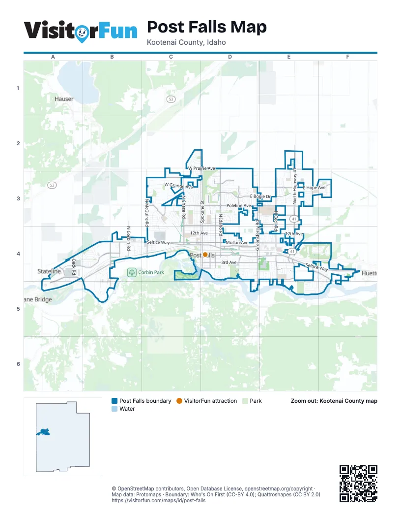
Street index of Post Falls
Each street on the sheet and the grid squares it crosses.
- North Highway 41E2, E3, E4
- East Seltice WayD4, E4, F4
- West Seltice WayA4, B4, C4, D4
- North Spokane StreetD2, D3, D4
- West Prairie AvenueC2, D2, E2
- East Horsehaven AvenueD3, E3
- North Pleasant View RoadB4
- Ross Point RoadE4
- North Herborn PlaceE4
- East Mullan AvenueD4, E4, F4
- East Poleline AvenueD3, E3
- North Idaho RoadD2, D3, D4
- North Greensferry RoadD3, D4
- South Spokane StreetD4
- East 3rd AvenueD4, E4
- East Bogie DriveE2, D3, E3
- North Cecil RoadE3, E4
- East 12th AvenueD4, E4
- East 16th AvenueD3, E3
- East Polston AvenueD4
- West Pointe ParkwayA4, A5
- North McGuire RoadC3, C4
- North Syringa StreetD3, D4
- West Expo ParkwayA4, B4
- East Hope AvenueD3, E3, F3
- North Chase RoadC3, C4
- East 1st AvenueD4, E4
- North Henry StreetD3, D4
- North Lincoln StreetD3, D4
- East Maplewood AvenueE4, F4
- West Poleline AvenueC3, D3
- West Riverbend AvenueB4, B5
- West Mullan AvenueC4, D4
- East Ponderosa BoulevardD4, E4
- East 4th AvenueD4
- North Meyer RoadF3
- East Penrose AvenueD3
- West Fisher AvenueC3
- North Beck RoadA4
- North Clark Fork ParkwayC3
- North Corbin RoadB4
- North Bay StreetD4
- South Greensferry RoadD4, D5
- North Fennecus RoadE3
- East 15th AvenueD3
- West 15th AvenueC3, D3
- South Pleasant View RoadB4, B5
- North Idahline RoadB4
- North Baugh WayA4
- North Spencer StreetE4
- South Spencer StreetE4
- West 5th AvenueB4
- South Ross Point RoadE4, E5
- North Santium DriveC3
- North Seeley StreetF4
- North Cedar StreetE4
- Goude StreetD4
- South Riverside Harbor DriveE4, F4, F5
- East 2nd AvenueD4, E4
- West Clearwater LoopB4, B5
- West Grange AvenueC3, D3
- North Charleville RoadE2, E3
- North Stagecoach DriveC3, D3
- North Compton StreetC3, C4
- East Inverness DriveE4, F4
- North Alfalfa LoopD3
- North William StreetD3, D4
- North Frederick StreetD3, D4
- West Polo Green AvenueC3
- North Howell RoadC3
- North Quail Run BoulevardD3
- East Early Dawn AvenueE3, F3
- North Willamette DriveC3, C4
- North Catherine StreetC3, C4
- East Singing Hills DriveD3
- North Post StreetD3, D4
- West Gumwood CircleA4, B4
- West Staples RoadC3
- South Lochsa StreetB4, B5
- West Midway AvenueC3
- North Treaty Rock BoulevardC3, D3
- East Warm Springs AvenueD3
- North Shelburne LoopD3
- East Shoreline DriveE5
- North Rawhide Ridge RoadC3
- West Jacklin RoadA4, B4
- East 11th AvenueD4
- North Cyprus Fox LoopE3
- North Viking LoopE3
- Empire Center BoulevardC4
- North Zorros RoadE3
- West Okanogan AvenueC4
- North Coles LoopF4
- West Palmwood LaneA4, B4
- Scotsworth StreetC2
- North Bunchgrass DriveD3
- North Silkwood DriveB4
- West Alsea LoopC3
- North Chetco DriveC3, C4
- North Oconner BoulevardE3
- East Warbler LaneD3
- North Radiant Star RoadC3
- East Mossberg CircleE5
- East Dorado AvenueE3, F3
- East Killdeer AvenueE3
- East 10th AvenueD4
- East 14th AvenueD4
- East 9th AvenueD4
- East 13th AvenueD4
- East Railroad AvenueD4
- East 21st AvenueD3
- West 13th AvenueC4, D4
- West 14th AvenueC4, D4
- West 12th AvenueC4, D4
- Brookie DriveD2, D3
- East Weatherby AvenueE4, E5
- North Mackenzie DriveD3
- East Teton AvenueD3
- East 6th AvenueD4
- North Dundee DriveE4, F4
- East Galway CircleE3
- Wollaston DriveC3, C4
- East Tiger AvenueD3
- Allenby RoadD3
- East Park LaneD4
- South Ponderosa LoopE4
- North Elm RoadB4
- North King Arthur BoulevardC4
- West Yaquina DriveC3
- North Cassiopeia StreetF3
- West Tennessee AvenueC3, D3
- East Commerce LoopF4
- East White Sands LaneD3
- Sundance DriveD4, D5
- East Coeur d'Alene AvenueD4
- West Evening Star RoadC3
- North Chisholm CourtE4
- East 5th AvenueD4
- East Plaza DriveD4
- West Saint Joe AvenueB5
- East Bogie AvenueE3
- East 22nd AvenueD3, E3
- North Sparrow LoopD3
- West 4th AvenueC4, D4
- East Millworx LoopD4
- North Distant Star RoadC3
- South Post Falls DriveD4, E4
- East Schneidmiller AvenueD4
- North Patridge LoopD3
- North Creative WayB4
- West 22nd AvenueC3, D3
- East Steamboat BendF4
- North Pine StreetC3, C4
- East Frazier DriveE4, F4
- East Woodland DriveE4, F4
- North Corvus StreetF3
- East Stoneybrook LoopD3
- West Jenicek LoopC3
- North Arrowleaf LoopC2, C3
- North Backweight LaneD3
- West Moorfield AvenueC2, D2
- East Bobwhite LaneD3
- East Thrush DriveD3
- South Osprey DriveE4, E5
- West Ashworth LaneC3, D3
- West Dawn AvenueB4, C4
- West Snoqualmie AvenueC3
- Bentley PlaceD4
- North Lean StreetC4
- North Sand Trap WayD3
- North Columbia StreetF3, E4
- West Watercress AvenueC3
- North Andromeda StreetF3
- Forest Glen BoulevardD4, E4
- West Iron Horse CircleC4
- North Post Falls DriveD4, E4
- West Falling Star LoopC3
- West Selway AvenueB4
- West Hydrilla AvenueC3
- South Pinewood DriveE4
- East 19th AvenueD3
- West Integrity WayA4
- Sterling DriveE4
- North McReynolds DriveC4, D4
- North Slazenger LaneC2, D2, C3, D3
- North Harlequin DriveE4
- West Tualatin DriveC3, C4
- West Hedgewood AvenueA4, B4
- North Pioneer Ridge DriveC3
- East Percival AvenueD3
- South Westwood DriveE4
- Trade AvenueE2
- North Innovation WayB4
- West Renshaw AvenueC2, D2
- East Sand Wedge DriveD3
- East Tall Timber LoopD4
- East Triumph AvenueD3
- Eaat Glacier Peak DriveD3
- North Sugar Maple TrailE4
- West Satsop AvenueC4
- West Malad AvenueC3
- East Ferry Landing AvenueD4, E4
- South Beck RoadA4, A5
- West Elk DriveB4
- West Bridle LaneC3
- North Serenity AvenueC3
- North Blaze LoopD3
- North Guy RoadC2, C3
- North Tucana StreetF3
- Sunset DriveD4
- North Cormac LoopE3
- West Wellington AvenueC2, D2
- Sharon DriveC3
- East 7th AvenueD4
- North Slice DriveD3
- North Foxglove LaneC3
- East Knapp DriveD3, E3
- West Citruswood DriveA4, B4
- Crown Pointe StreetC2
- East Jordan DriveE4
- South Ridgewood DriveE4
- North Durrow LoopE3
- East Connery LoopE2, E3
- East Kit Fox LaneE3
- East Fennec Fox LaneE3
- East Norma AvenueE3, F3
- East Autumn Crest LoopD3
- North Chehalis StreetC3
- North Maranatha DriveB4
- North Promenade LoopE4
- North Vine StreetE4
- Coho RoadD4
- East Knapp CircleE3
- East Laurelbrook DriveE3
- North Idaho StreetD4
- East Yellowstone AvenueD3
- North Ivy Lane StreetD3
- North Brigger StreetD4
- North Megan StreetB4
- East Bunting LaneD3
- North Nicholson Center StreetE3
- Divot AvenueD3
- East 18th AvenueD3
- West Peery LoopB4
- West Chukar CircleB4
- Shetland AvenueD4
- North Moonstone StreetE3, E4
- East Mountain View DriveE4
- Shannon LaneD4
- East Bremington StreetD4, E4
- Fordham StreetE3
- Lansdowne StreetE3, E4
- North Enterprise StreetE3
- North Fir StreetC3, C4
- North Forsythia CircleE4
- West 20th AvenueC3, D3
- West 21st AvenueC3, D3
- West Palouse DriveC3
- North October Glory StreetE4
- West 19th AvenueC3, D3
- West Lemmonwood DriveB4
- East Covington AvenueE4
- North Ivory LaneE3
- East Edmondton AvenueD4
- East Shore CoveF4, F5
- North McMullen DriveE3
- East Strand AvenueD4
- North Larri Lee StreetB4, C4
- North Luke LaneD3
- East Capella LaneF3
- Townsend LoopE4
- North Chroghan DriveE3
- North Cool Water DriveD3
- East Culpeo AvenueE3
- North Ping RoadD3
- North Titleist WayD3
- Rodkey DriveD5
- South Wide River RoadD4
- South Majestic View DriveB4, B5
- South Idaho StreetD4
- East Sirius LaneF3
- North Grants CourtD3
- North Lucas StreetD3
- West Jester WayC4
- East 20th AvenueD3
- North Garden Plaza CourtE4
- North Scott StreetD4
- North Lea StreetD3
- East Blair AvenueD3
- North Walnut StreetC3
- Park Wood PlaceD4
- East Lyra LaneF3
- West 23rd AvenueC3, D3
- North Summer Rose StreetD3
- East Portside CourtE4, F4
- North Pyroclast StreetE3, E4
- South Forest Glen BoulevardE4
- Timber LaneE4
- North Kaniksu StreetC4
- North Ewell CourtE3, E4
Places on the map
- A Better Storage Solution
- All In One Mini Storage
- Aspen Nursery
- Beck Park
- Black Bay Park
- Blue Dog RV Post Falls
- Boulder Storage Solutions
- Cabela's
- Chase Sports Field Complex
- Coeur d'Alene RV Resort
- Evergreen Cemetery
- Falls Park
- FedEx Office
- Flying J Travel Center
- Ford Rock
- Giant Storage
- Greensferry Elementary
- Greyhound Park Event Center
- Highlands Golf Course
- Karen Streeter Greenway
- Kiwanis Park
- Kootenai Clinic Post Falls
- Love's Travel Stop
- Mullan Trail Elementary School
- North Idaho Outlet Mall
- Northwest Specialty Hospital Medical Park
- Pleasant View Business Center
- Poleline Self Storage
- Ponderosa Elementary School
- Post Falls Factory Stores
- Post Falls High School
- Post Falls Landing
- Post Falls Middle School
- Post Falls RV Campground
- Prairie Falls Golf Course
- Q'emiln Park
- Real Life Ministries
- Riverbend Commerce Park
- Ross Point Camp & Conference Center
- The Pointe at Post Falls
Next to Post Falls
- Hauser
- Huetter
- Spokane Bridge
- Stateline
© OpenStreetMap contributors, Open Database License, openstreetmap.org/copyright · Map data: Protomaps · Boundary: Who's On First (CC-BY 4.0); Quattroshapes (CC BY 2.0)















