

Idaho map
Rathdrum map
About 12,626 people live here (Census Bureau, 2024 estimate). The sheet's index lists 231 streets; West Highway 53, North Highway 41 and North Meyer Road cross the most grid squares. Also on it: Avista Dog Park, Lakeland High School and Radiant Lake.
Open the map (PDF, US Letter)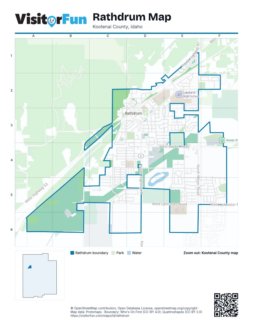
Street index of Rathdrum
Each street on the sheet and the grid squares it crosses.
- Darby CourtE1
- North Highway 41E1, D2, E2, D3, D4, D5
- North Meyer RoadE1, E2, E3, E4, E5, E6
- North Reindeer DriveE1
- West Basswood DriveE1
- West Diagonal RoadE1
- West Eden CourtE1
- West Kamloops DriveE1
- West Legacy DriveE1
- West Timberline StreetE1, E2
- North McCartney StreetC2, D2, D3
- North Boise StreetD2
- North Gray StreetD2, D3
- North Kootenai StreetD2
- North McKinley StreetD2
- North Mill StreetD2, D3
- North Oneida StreetD2
- North Roosevelt StreetD2
- North Spring StreetD2
- North Stevens StreetD2, D3, D4
- North Vernon StreetD2, E2, E3
- North Washington StreetD2, D3
- West Ada StreetD2
- West Bingham StreetD2
- West Canal StreetD2, C3
- West Highway 53D2, E2, F2, B3, C3, D3, B4
- West Idaho StreetD2
- West Logan StreetD2
- West Main StreetD2, E2, D3
- West Missouri AvenueD2
- West Post StreetD2, D3
- West Sylte Ranch RoadD2
- Dayton AvenueE2, F2
- North Brothers StreetE2
- North Gina CourtE2
- North Liane LaneE2, E3
- North Pineview StreetE2, D3
- North Style StreetE2
- North Vera StreetE2, E3
- North Westwood DriveE2
- West Astoria LoopE2, F2
- West Christine StreetE2
- West Commercial Park AvenueE2
- West Heritage StreetE2
- West Highway 53 / North Highway 41E2
- West Prosperity LaneE2
- West Theo StreetE2
- Cloverdale AvenueF2
- West Pelican LoopF2
- Latah StreetC3
- North Alturas StreetC3, D3
- North Arbor StreetC3, C4
- North Greensferry RoadC3, B4, B5, B6
- North Latah StreetC3
- North Meadow View CourtC3
- North Parkway StreetC3, C4
- North Roth CourtC3
- North State StreetC3, C4
- South Arbor StreetC3
- West 4th StreetC3, D3
- West Elmore StreetC3, D3
- West Hidden Valley RoadC3
- West Lemhi StreetC3
- West Meadow Brook CircleC3, D3
- West Montana StreetC3, D3
- West Park LoopC3, D3
- Cassia StreetD3, D4
- North Alabama StreetD3
- North Anthony StreetD3
- North Carter LaneD3
- North Cassia StreetD3, D4
- North Coeur d'Alene StreetD3
- North Kimo CourtD3
- North McAuley StreetD3
- North Nixon LoopD3, D4
- North Ohio StreetD3, D4
- North Reagan CourtD3
- North Treehouse CourtD3, D4
- Nortj Egbers StreetD3
- P1FCU Rathdrum Drive-ThroughD3
- P1FCU Rathdrum DrivewayD3
- West 2nd StreetD3
- West 3rd StreetD3
- West 5th StreetD3
- West Bard StreetD3
- West Bordon CourtD3
- West Clark StreetD3
- West Crenshaw StreetD3, E3
- West Division StreetD3
- West Fivepoint StreetD3
- West Lakeland StreetD3, E3
- West Lewis StreetD3
- West Lund StreetD3, E3
- West Macaw LaneD3, E3
- West Meadow Lark LaneD3, E3
- West Pine StreetD3, E3
- West Russell CourtD3
- West Sunrise StreetD3, E3
- West Wright StreetD3, E3
- North Aldo StreetE3
- North Beechwood StreetE3
- North Boxwood StreetE3
- North Heather StreetE3
- North Juniper StreetE3
- North Sedona StreetE3
- North Sunset StreetE3
- North Wright StreetE3, E4
- Tommy LaneE3
- West Flagstaff StreetE3
- West Manchester StreetE3
- West Melinda CourtE3
- West Riss AvenueE3
- West Santa Fe StreetE3
- West Silverado StreetE3
- West Tombstone StreetE3
- West Trevor StreetE3
- West Tudor StreetE3
- West Winchester StreetE3
- North Honu CourtB4
- West Burlington RoadB4, A5, A6
- North Cascade StreetC4
- North Golden Spike BoulevardC4, C5
- North Grand Canyon StreetC4, C5
- North International StreetC4, C5
- North Kings Canyon RoadC4, C5
- North Mount Hood RoadC4
- North Mount Rainier RoadC4
- North Rio Grande AvenueC4, C5
- North Schooner StreetC4
- West Arizona StreetC4, D4
- West Bryce Canyon StreetC4
- West California StreetC4, D4
- West Colorado StreetC4, D4
- West David StreetC4
- West Disc AvenueC4
- West Grand Teton StreetC4
- West Larch StreetC4
- West Mount Adams RoadC4
- West Mount Baker RoadC4
- West Mount Shasta RoadC4
- West Nagel LaneC4
- West Nagel RoadC4, D4, E4
- West Nebraska StreetC4, D4
- West Oregon StreetC4, D4
- West Rushmore StreetC4
- West Sawtooth StreetC4
- North Lauren LoopD4
- North Natalie StreetD4
- North Pristine CircleD4, E4, D5, E5
- North Rockwood CourtD4
- North Stream LaneD4, D5
- North Treasure Island CourtD4, D5
- West Boekel RoadD4, E4, F4
- West Kayak CourtD4, D5
- West Nevada StreetD4
- West Robin RoadD4, E4
- North Apollo StreetE4, E5
- North Corrigan StreetE4
- North Halley StreetE4, E5
- North Radcliff StreetE4, E5
- North Ramore CourtE4
- North Randall StreetE4
- North Thayer StreetE4, E5
- Thayer StreetE4
- West Bent Grass LaneE4, E5
- West Blacktail AvenueE4
- West Karlie LaneE4
- West Portrush DriveE4
- West Quail Ridge StreetE4, F4, F5
- Hiawatha AvenueF4, F5
- Lazy Ridge StreetF4, F5
- North Railway AvenueF4, F5
- West Lancaster RoadB5, C5, D5, E5, F5
- North Bale StreetC5
- North Big Horn Canyon StreetC5
- North Bushel StreetC5
- North Farmstead StreetC5
- North Kenosha LaneC5, C6
- Trump WayC5
- West Cultivator AvenueC5
- West Ferguson LaneC5, D5
- West Little Bighorn StreetC5
- West Oats AvenueC5
- West Range DriveC5
- West Seed AvenueC5
- West Seed LoopC5, D5
- West Splitrail AvenueC5, D5
- West Swather AvenueC5
- West Tractor AvenueC5
- West Yosemite StreetC5
- West Zion StreetC5
- Glistening CourtD5
- West Majestic AvenueD5, E5, F5
- Bermuda Grass LaneE5
- Buffalo Grass LaneE5
- North Borglum StreetE5
- North Polaris StreetE5
- North Reinhart StreetE5
- North Reward LoopE5
- North Zodiac LoopE5
- Radcliff StreetE5
- Shimmering CourtE5
- West Alliance StreetE5, F5
- West Buffalo Grass LaneE5
- West Conner StreetE5
- West Covenant StreetE5
- West Elmberry AvenueE5
- West Harmony StreetE5, F5
- West Lofty Ridge StreetE5, F5
- West Rambo StreetE5
- West Soldier Creek AvenueE5
- West Trestle StreetE5, F5
- Airhorn AvenueF5
- Axle CourtF5
- Deadwood AvenueF5
- Freight Train CourtF5
- Gandy Dancer StreetF5
- Gondola StreetF5
- North Freight Train CourtF5
- North Locomotive StreetF5
- North Voyagers StreetF5
- Pistol StreetF5
- Railway AvenueF5
- Saloon StreetF5
- Shortline StreetF5
- Tendor StreetF5
- West Twister StreetF5
- North High Noon CourtA6
- North Idaho RoadA6
- West Ok Corral RoadA6
- Brookshire AvenueE6
Places on the map
- American Eagle Automotive
- AutoZone
- Avista Dog Park
- B&B Boat Care Center
- Bell Tower Westwood Chapel
- Betty Kiefer Elementary
- C J's Family Tradition
- Calvary Rathdrum
- Columbia Bank
- Conoco
- Cooper Field
- Country Side Childcare
- D&S Carpentry
- Dakota Storage
- Dance Theatre Northwest
- DQ Grill & Chill
- Dwelling Place
- Epic Storage
- Generations Assisted Living
- Giorgi's
- Goodness Grows Children's Garden
- GunfightersINC
- Idaho Central Credit Union
- J & R Electronics
- John Brown Elementary School
- John Brown Playfield
- Johnson Custom Iron
- Kootenai Technical Education Campus
- Lake City Auto Care Rathdrum
- Lakeland High School
- Lakeland Junior High School
- Majestic Park
- Mountainview Alternative High
- Parkside Plaza
- Pine Grove Cemetery
- Radiant Lake
- Rathdrum Dog Park
- Stub Meyer Park
- Thayer Park
- Westwood Storage Center
© OpenStreetMap contributors, Open Database License, openstreetmap.org/copyright · Map data: Protomaps · Boundary: Who's On First (CC-BY 4.0); Quattroshapes (CC BY 2.0)















