

Idaho map
Rexburg map
About 40,695 people live here (Census Bureau, 2024 estimate). The sheet's index lists 277 streets; North 2nd East, South Yellowstone Highway and South 2nd East cross the most grid squares. Also on it: Rexburg-Madison County Airport, Rexburg City Limits and Teton Lakes Golf Course.
Open the map (PDF, US Letter)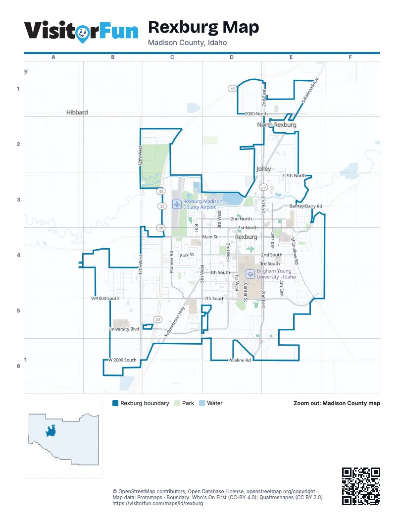
Street index of Rexburg
Each street on the sheet and the grid squares it crosses.
- West 2000 NorthD1, E1
- East 2000 NorthE1
- North 2nd EastE1, E2, E3, E4
- North Salem RoadE1
- North Yellowstone HighwayE1, E2
- South Railroad AvenueE1
- North 12th WestB2, B3, B4
- West 1750 NorthB2, C2
- West 1600 NorthC2
- American StreetE2
- Bond AvenueE2
- Dividend DriveE2
- East Moran View RoadE2
- Ella LaneE2
- Hope StreetE2
- Lowe StreetE2, E3
- Profit StreetE2
- Stationery RoadE2
- Stegelmeier LaneE2
- Stocks AvenueE2
- Stonebridge StreetE2, E3
- Thomson Farms RoadE2
- Angela DriveC3
- Chad DriveC3
- Eagle Park DriveC3, D3
- East Sunset CircleC3, C4
- Firehole DriveC3
- Jet Stream DriveC3
- K StreetC3, C4
- Marianne DriveC3
- Melanie DriveC3
- North 1500 WestC3, C4
- North 5th WestC3, C4, D4
- Summerwood DriveC3
- West 2nd NorthC3, D3
- West 4th NorthC3
- West Fourth North StreetC3, D3
- West Sunset CircleC3, C4
- Brittney DriveD3
- Cul de Sac StreetD3
- East 2nd NorthD3, E3
- East 3rd North StreetD3, E3
- East 7th NorthD3, E3
- North 1st EastD3, D4
- North 1st WestD3, D4
- North 2nd WestD3, D4
- North 3rd WestD3, D4
- North 4th WestD3, D4
- North Center StreetD3, D4
- West 3rd NorthD3
- Barney Dairy RoadE3
- Bluebell StreetE3
- Canyon Springs DriveE3
- Carlow DriveE3
- David CourtE3
- East 4th NorthE3
- Gary DriveE3
- Laleene DriveE3
- Laurel StreetE3
- Lilac StreetE3, E4
- Lorene StreetE3
- Lupine StreetE3
- Madison AvenueE3, E4
- Marigold StreetE3, E4
- Max DriveE3
- Meadowbrook StreetE3
- Mill Stream StreetE3
- Nina DriveE3
- North 3rd EastE3, E4
- North 4th EastE3, E4
- North Hill RoadE3, E4
- Randy DriveE3
- Rodney DriveE3
- Susan DriveE3
- Syringa StreetE3
- Tanglewood DriveE3
- Violet StreetE3
- Walker DriveE3
- Coyote Willow WayB4, C4
- South 12th WestB4, B5
- South 2100 WestB4, B5
- South 2275 WestB4, B5
- South 2315 WestB4, B5
- South 2400 WestB4, B5
- South 2470 WestB4, B5
- Summerfield LaneB4
- West 550 SouthB4
- West 690 SouthB4
- West Highway 33B4
- West Main StreetB4, C4, D4
- Aries DriveC4
- Blackhawk DriveC4
- Bruce CircleC4
- Capital LaneC4
- Colonial WayC4
- Cook StreetC4
- Countryside AvenueC4, C5
- Douglas DriveC4
- Engleman StreetC4
- Freedom LaneC4
- Gemini DriveC4
- Georgetown DriveC4
- Golden Willow DriveC4, C5
- Grand LoopC4
- Green Willow DriveC4
- Griffin StreetC4
- Henderson AvenueC4
- Huckleberry CircleC4
- Independence WayC4
- Jill DriveC4
- Johnson StreetC4
- Liberty LaneC4
- Lodgepole StreetC4
- Mariah AvenueC4, C5
- Mark AvenueC4
- North 6th WestC4
- Oaktrail DriveC4
- Pahsimeroi BoulevardC4
- Park StreetC4
- Parkside DriveC4
- Pinehaven StreetC4
- Pioneer RoadC4, C5
- Pollard AvenueC4
- Polo DriveC4
- Ponderosa AvenueC4
- Poplar CircleC4
- Rebecca AvenueC4
- Sawtelle AvenueC4
- Seagull DriveC4
- Sequoia AvenueC4
- South 5th WestC4, D4, C5
- South Yellowstone HighwayC4, D4, C5, C6
- Summit DriveC4
- Sunflower RoadC4, C5
- Tamarack AvenueC4
- Taurus DriveC4
- Trejo StreetC4
- Twisted WillowC4, C5
- West 190 SouthC4
- West 1st NorthC4, D4
- West 2nd SouthC4, D4
- West 5th SouthC4, D4
- Widdison LaneC4
- Yost StreetC4
- Bare StreetD4
- Carlson AvenueD4
- College AvenueD4
- Cornell AvenueD4
- East 1st NorthD4, E4
- East 1st SouthD4, E4
- East 2nd SouthD4, E4
- East 3rd SouthD4, E4
- East Main StreetD4, E4
- East Viking StreetD4, E4
- Orchard AvenueD4
- Physical Plant WayD4, D5
- Princeton CourtD4
- Salem AvenueD4
- South 1st EastD4
- South 1st WestD4, D5
- South 2nd WestD4, D5
- South 3rd WestD4, D5
- South 4th WestD4, D5
- South Center StreetD4, D5
- Steiner AvenueD4
- Webster AvenueD4
- West 1st SouthD4
- West 3rd SouthD4
- West 4th SouthD4
- West Benlit Estates StreetD4
- West Campus StreetD4
- West Viking StreetD4
- Apache AvenueE4
- Ash AvenueE4
- Birch AvenueE4
- Centennial LoopE4
- Commanche DriveE4
- Dell DriveE4
- East 4th SouthE4
- East 5th SouthE4
- Edith CircleE4
- Elm AvenueE4
- Harvard AvenueE4
- Hidden Valley RoadE4
- Holly StreetE4
- Jerry AvenueE4
- Linden AvenueE4
- Maple DriveE4
- Mill Race RoadE4
- Mohawk AvenueE4
- Morgan DriveE4
- Nez Perce AvenueE4
- North Millhollow RoadE4
- Oak AvenueE4
- Palmer CircleE4
- Professional Plaza StreetE4
- Reed StreetE4
- Ricks AvenueE4
- Rolling Hills DriveE4
- Rosewood DriveE4
- Shoshone AvenueE4
- South 2nd EastE4, D5, E5, D6
- South 3rd EastE4
- South 4th EastE4, E5
- South 5th EastE4
- South Hidden Valley RoadE4, E5
- South Millhollow RoadE4, E5
- Star View DriveE4
- Terra Vista DriveE4
- Vale LaneE4
- Yale AvenueE4
- Arctic Willow DriveB5, C5
- South 12thWestB5, B6
- South 2380 WestB5
- University BoulevardB5, C5, D5
- West 1000 SouthB5
- West 1500 SouthB5, C5
- West 7th SouthB5, C5, D5
- West 860 SouthB5
- West 880 SouthB5
- West 900 SouthB5
- West 960 SouthB5
- Andrews PlaceC5
- Casper AvenueC5
- Cornelison AvenueC5
- Elizabeth StreetC5
- Everett PlaceC5
- Golden Beauty DriveC5, C6
- Golden Willow CircleC5
- Handcart LaneC5
- Legacy LaneC5
- Logan StreetC5
- Mikan DriveC5
- Ryan StreetC5
- Sarah StreetC5
- Sparrowhawk DriveC5
- West 6th SouthC5, D5
- West Mikan DriveC5
- Willow Brook CircleC5
- Willow Brook DriveC5
- Crestview DriveD5, E5
- East 7th SouthD5, E5
- Franklin DriveD5, E5, D6, E6
- Grandview DriveD5
- Greenhaven CourtD5
- Hillview DriveD5
- Horizon DriveD5, D6
- Sage StreetD5
- Sunrise DriveD5, E5
- Valinda LaneD5
- Westview DriveD5, D6
- Westwood CircleD5
- Westwood DriveD5
- Autumn courtE5
- Eagle CourtE5
- Eagle Summit StreetE5
- Eaglewood DriveE5
- Hillside DriveE5
- Jefferson DriveE5
- Stone DriveE5, E6
- Talon DriveE5
- Washington BoulevardE5
- Wheatland CircleE5
- Wheatland DriveE5
- Smith Ranch RoadB6
- West 1829 SouthB6
- West 2000 SouthB6
- West Poleline RoadB6, C6, D6
- Fairview AvenueD6
- Meadowview AvenueD6
- Morningside DriveD6
- Pleasant ViewD6
- South Skyview DriveD6
- Valley View DriveD6
- Clover CourtE6
- East Poleline RoadE6
- Ridge View DriveE6
Places on the map
- A-1 Rentals Inc.
- Adams Elementary
- Advance Auto Parts
- Albertsons
- AmericInn Lodge and Suites
- Anytime Fitness
- Applebee's
- Ard's Paint and Glass
- Ark Security & Electronics
- AutoZone
- Bank of Commerce
- Bed Place
- Beehive Federal Credit Union
- Big 5 Sporting Goods
- Blister's BBQ
- Brigham Young University - Idaho
- Broulim's Supermarket
- Builders FirstSource
- C-A-L Ranch Stores
- Carousel
- Central Storage
- John Deere
- Kennedy Elementary School
- Madison High School
- Madison Junior High School
- Madison Memorial Hospital
- Madison Middle School
- Porter Park
- Quick Ship N' Copy
- Rexburg City Limits
- Rexburg Golf Club
- Rexburg Nature Park
- Rexburg Rapids
- Rexburg-Madison County Airport
- Smith Park
- Teton Lakes Golf Course
- Teton River Village
- Teton Vu Drive In
- Walmart Supercenter
Next to Rexburg
- Hibbard
- North Rexburg
© OpenStreetMap contributors, Open Database License, openstreetmap.org/copyright · Map data: Protomaps · Boundary: Who's On First (CC-BY 4.0); Quattroshapes (CC BY 2.0)















