

Idaho map
Valley County map
About 12,777 people live here (Census Bureau, 2024 estimate). The sheet's index lists 300 streets; West Mountain Road, Main Street and Lakeshore Drive cross the most grid squares. Things to do inside the boundary: Artisan's Tour in the Mountains.
Open the map (PDF, US Letter)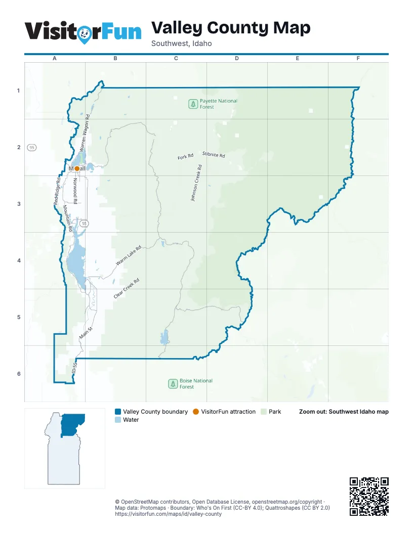
Street index of Valley County
Each street on the sheet and the grid squares it crosses.
- Main StreetA3, B4, A5, B5
- ID 55A5, A6
- West Lake StreetA2
- North 3rd StreetA2
- South 3rd StreetA2, A3
- East Lake StreetA2
- South Main StreetB4
- Lake StreetA2
- North Main StreetB4
- East Deinhard LaneA2
- Deinhard LaneA2
- Boydstun StreetA2
- Landmark Stanley RoadC4, C5, D5
- Warm Lake RoadB4, C4
- Lick Creek RoadA2, B2, C2
- South Fork Salmon River RoadC2, C3, C4
- West Mountain RoadA2, A3, A4, A5, B5
- Warren Wagon RoadB1, A2, B2
- Deadwood RoadC5
- Farm To Market RoadB3
- Cabarton RoadB4, A5, B5
- National Forest Development Road 422A4
- Deadwood Road - National Forest Development Road 555C5, C6
- National Forest Development Road 21B1
- Smylie LaneA3
- West Roseberry RoadA3
- Lakeshore DriveA4, B4, A5, B5
- Elo RoadA3, B3
- South Samson TrailA2, A3
- Spring Mountain Ranch BoulevardA2
- Tamarack Falls RoadA3
- South Mission StreetA2, A3
- East Roseberry RoadA3, B3
- Davis AvenueA2
- North Samson TrailA2
- Village DriveA4, B4
- North Mission StreetA2
- Wooley AvenueA2
- Lake Cascade ParkwayB4
- Stibnite Street EastA2
- Railroad AvenueA2
- West Valley RoadA2
- Wisdom RoadA2
- Pine StreetA2
- VillageDriveA4
- Elk Creek RoadC1, D1
- Clear Creek RoadB4, C4, B5
- Johnson Creek RoadC2, C3, C4
- Burnt Log RoadC3, D3, C4
- Artillery Dome RoadC4, D4
- Edwardsburg RoadD1, D2
- Thunder Mountain RoadD2, E2
- North Gold Fork Loop RoadB3, B4
- East Fork RoadC2
- Eagle Nest-Gold Fork River RoadB4
- Paddy Flat RoadA3, B3
- Stibnite RoadC2, D2
- National Forest Development Road 417B5
- Stolle Meadows RoadC4, C5
- Wilson Creek RoadB1, C5
- Sloans Point RoadB3, B4
- Bear Valley RoadC5, D5, C6
- Two-Bit Six-Bit RoadC3, C4
- Silver Creek RoadB5, B6
- High Valley RoadA5, A6
- Meadow Creek Lookout RoadD2, D3
- Middle Fork RoadB5, B6
- Norwood RoadA3
- Cabarton High Valley RoadA5
- West Fork Creek Road/FS Road 418B5
- Gold Fork RoadB3, B4
- National Forest Development Road 670B5, B6
- Dagger Falls RoadD4, D5
- Snow Bank Mountain RoadA5
- Red Ridge RoadA2, A3
- Dry Buck RoadA6
- Flat Creek RoadB3, B4
- Bearskin Creek RoadC5
- National Forest Development Road 435A4
- Fisher Creek RoadA1, A2
- Nisula RoadA3
- National Forest Development Road 498B3, B4
- Bridge Creek RoadB5
- Horsethief RoadB4, B5
- National Forest Development Road 626A5
- Brundage Mountain RoadA2
- Old State RoadA3, A4
- Ridgeview RoadB3
- East Side RoadA2, B2
- Old Dry Buck RoadA6
- Boulder Lake RoadB3
- Sugar Creek RoadD2
- National Forest Development Road 389B3
- Sand Creek RoadC4, D4
- Crown Point ParkwayA4, B4
- Silver Creek Lookout RoadB5
- Foolhen Ridge Fire TrailB3
- National Forest Development Road 421A5
- National Forest Development Road 754A6
- National Forest Development Road 410B5
- Colter RoadB4
- Powelson Creek RoadB3
- Packer John RoadA5, A6
- US Forest Service Road 569C5, C6
- Willow One RoadA4, A5
- Corral Creek RoadB5
- Barker LaneA3, B3
- Skunk Creek RoadB5
- National Forest Development Road 582C6
- NF-422A3
- National Forest Development Road 099A6
- Upper Camp Creek RoadB3
- West Fork Creek RoadB5
- Lower Powelson Creek RoadB3
- Brush Creek RoadB1, B2
- Blackhawk Lake DriveA3
- Smiths Ferry DriveA5, B5
- Logan Creek RoadD1
- West Lake Fork RoadA3
- National Forest Development Road 071A6
- Dawn DriveA3
- Spink LaneA3, B3
- Gray LaneB5
- Bacon Creek RoadB5
- Thunder City RoadB4
- Smalley RoadB4
- Deer Run RoadB5
- Heinrich LaneA3
- Davis Creek LaneB3
- East Mountain RoadB5
- Finn Church LaneA3, B3
- Fairbrother LaneA3
- Whitetail DriveA2
- National Forest Development Road 400B4
- Sixty LaneB5
- Shore DriveA4, B4
- Kennally Creek RoadB3
- Koskella RoadB3, B4
- Granite Lake RoadA1, A2
- National Forest Development Road 433B4
- Rapid Creek RoadB3
- National Forest Development Road 596B6
- Nasi LaneA3, B3
- Rio Vista BoulevardA2
- Pine Lakes Ranch DriveB4
- Gatfield RoadB5
- Hereford RoadA3, A4
- Council RoadA3
- Roseberry RoadB3
- River Ranch RoadA2, A3
- Ranch CircleA6
- Round Valley RoadB5
- Gold Dust RoadB5
- Potter LaneA3, B3
- Loomis LaneA3, B3
- Goslin LoopB5
- Kennedy LaneB5
- Silver Fox TrailB3
- South Fork RoadC4
- National Forest Development Road 693B6
- Duncan LaneB3
- East Lake Fork RoadA3, B3
- Siscra RoadA3
- Little Pearsol RoadB4
- MainlineB3
- Timberrim DriveB5
- Mountain Air DriveA4, B4
- Pearson LaneA3
- Kantola LaneA4, B4
- Spoor RoadB5
- Eagle Nest RoadB4
- Quartz Creek RoadC2
- Paddy Pond RoadB3
- Homestead RoadB3
- National Forest Development Road 401B3
- Scheline LaneA3
- Wilderness Lake RoadA6
- Jughandle DriveB3
- Herrick LaneB5
- Ashton LaneB3
- Whitewater DriveA4
- Boundary Creek RoadD4
- Easy StreetA3
- Truckee TrailB4
- Sundance DriveA3
- Day Star Lane / Day StarA4
- Boulder Rock RoadC4
- Maki LaneA3
- Crest PlaceB5
- Majestic View DriveA2
- North Shoreline DriveC4
- Lantern WayA6
- Club Hill BoulevardA2
- Osprey Ridge RoadB4
- Fawnlilly DriveA3
- Valgem RoadA6
- Eastside DriveB2
- Wilderness Ranch RoadA6
- Migratory Ridge WayA2
- Lupine LaneA2
- University DriveA2
- East Prospectors DriveB5
- Finlandia RoadB3
- Heikkila LaneB3
- Moonridge DriveA3
- Collier View RoadB5
- Hasbrouck LaneB5
- Osprey View DriveA2
- Mather RoadA2
- Morgan DriveA2
- Titus LaneB3
- Maki RoadA3
- West Prospectors DriveB5
- Johnson LaneA3
- Ridgeview WayB3
- Country WayA3
- Panorama DriveB4, B5
- National Forest Development Road 402B4
- Bitterroot DriveA2
- Burnt Wagon TrailA4
- Hilltop RoadB5
- Kokanee DriveA3
- Vista Point BoulevardB4
- Alpha LaneB5
- Six Mile RoadB5
- North Norwood RoadA3
- Pearl Creek RoadB1
- Paradise Valley RoadC4
- Brookdale DriveA3
- Alberta CourtA4, B4
- Payette DriveA2
- Hill House LoopA3
- Callender RoadB5
- Pleasant Acres DriveA3
- Williams Creek LoopA2
- Arlin Place TrailA4
- Wildwood DriveA3
- Forest StreetA2
- Rash LaneB3
- Knob Hill DriveA3
- Squaw Meadows RoadB1
- Moore DriveA5
- Ilka LaneA3
- Vili RoadB3
- Atkin LaneB5
- Lakeview AvenueA2, B2, B4
- Dagger Falls Campground RoadD4
- Alta Vista DriveB3
- Lichen LaneA2
- Aspen Ridge LaneA2
- Cascade DriveA3, A4
- Dustin RoadC1
- Moon DriveA3
- Lakeridge DriveA2
- Song Sparrow DriveA2
- North Sawyer StreetB4
- Lark TrailA4
- Gamann DriveB5
- Rogers LaneA3
- Pioneer RoadA3
- Hogue Hollow DriveA3
- Sandhill LaneA3
- Garden LaneA3
- Carefree LaneA3
- Shoreline DriveC4
- Forest Lake CircleA3
- Jefferson RoadB3
- Ponderosa LaneB5
- Wallace LaneA3
- Crownpoint ParkwayA4
- Cameron DriveA3
- Eld LaneA3
- One Eleven WayB5
- Snowbank mountain RoadA5
- Lake Trail DriveA3
- Pilgrim Cove RoadA2
- Spring Valley RoadA3
- West 4 LaneA4, B4
- Lee WayA4
- Bear TrailA4
- StonebreakerA4, B4
- Laurel DriveA4, B4
- Lakeview DriveA4, B4
- Schultz LaneA3
- Rising LaneB5
- Park StreetA2
- Down End WayA4
- Red Fox DriveB5
- Bear Valley Cutoff RoadD5
- Harnden DriveA5
- Willow Creek RoadA4
- Eagle TrailA4
- Wild Goose CourtA3
- Peterson LoopB5
- Angus LaneA3
- Pine Cone LaneB5
- Alder WayB5
- Crowley LaneA2
- Meadow RoadA2
- Heights LoopB5
Things to do on the Valley County map
Places on the map
- Bear Basin Nordic Center
- Boulder Lake
- Box Lake
- Browns Pond
- Calendar Reservoir
- Cascade
- Cox Ranch/VO Ranch
- Cruickshank Reservoir
- Davis Reservoir
- Deadwood Reservoir
- Donnelly
- Enos Lake
- Frank Church-River of No Return Wilderness
- Granite Lake
- Hait Reservoir
- Hasbrouck Ranch Nordic Trails
- Herrick Reservoir
- Horse Heaven
- Horsethief Reservoir
- Jemima K Reservoir
- Kennally Lakes
- Lake Cascade
- Lily Marsh
- Little Payette Lake
- Loon Lake
- McCall
- McCall Activity Barn
- McCall Golf Club
- McCall Municipal Airport
- Mud Lake
- Payette Lake
- Payette National Forest
- Ponderosa State Park
- Riordan Lake
- Sisters Lakes
- Tamarack Resort
- Upper Jug Creek Reservoir
- Upper Payette Lake
- Wapiti Meadow Ranch
- Warm Lake
© OpenStreetMap contributors, Open Database License, openstreetmap.org/copyright · Map data: Protomaps · Boundary: Who's On First (CC-BY 4.0); Quattroshapes (CC BY 2.0)















