

Illinois map
Dixon map
About 15,156 people live here (Census Bureau, 2024 estimate). The sheet's index lists 273 streets; North Brinton Avenue, West River Street and Fox Trot Lane cross the most grid squares. Also on it: Dixon Correctional Center, Charles R. Walgreen Field and Page Park.
Open the map (PDF, US Letter)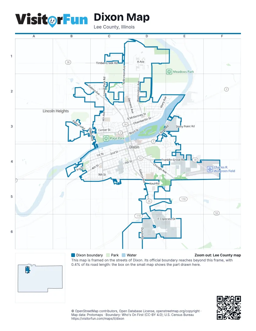
Street index of Dixon
Each street on the sheet and the grid squares it crosses.
- North Brinton AvenueC1, C2, C3, D3
- Timber Creek RoadC1, D1
- 1st StreetD1
- 2nd StreetD1
- 3rd StreetD1
- A AvenueD1
- B AvenueD1
- South AvenueD1
- Washington AvenueD1, D2, D3
- 4th AvenueC2, C3
- Apple StreetC2, D2
- Brigadoon DriveC2, D2
- Devonshire StreetC2, D2
- Ferris StreetC2
- Freedom WalkC2
- Goral CourtC2
- Heather LaneC2, D2
- Hubbell DriveC2
- Independence CourtC2
- Johnson AvenueC2, C3
- Liberty CourtC2
- Lowell Park RoadC2
- Marclare StreetC2, D2
- Medinah CourtC2
- North Court StreetC2
- North Dixon AvenueC2, D2, D3
- North Galena AvenueC2, C3, D3
- North Hennepin AvenueC2, C3
- Park StreetC2, C3
- Ann AvenueD2, D3
- Assembly PlaceD2, D3
- Badger CourtD2, D3
- Bonnie AvenueD2
- Cushing StreetD2
- Dorothy StreetD2
- East Graham StreetD2, C3
- Good StreetD2
- High StreetD2
- Institute BoulevardD2, D3
- Jane DriveD2, E2
- Mably CourtD2
- Mary AvenueD2, E2, D3
- Murphy StreetD2
- Myrtle AvenueD2, D3
- North Dement AvenueD2, D3
- North Jefferson AvenueD2, D3
- Ogletree PlaceD2, D3
- Ogletree TerraceD2
- Orchard StreetD2
- Phyllis DriveD2, E2
- Pine Meadow DriveD2
- Prescott AvenueD2
- Sinnissippi StreetD2, D3
- Sproul StreetD2
- Steinman StreetD2
- Tilton Park DriveD2, E2
- University PlaceD2
- Zuend CourtD2
- Kilgore RoadB3
- Palmyra RoadB3
- Reynoldswood RoadB3
- Summit AvenueB3
- Veterans ParkwayB3
- Willett AvenueB3, C3
- 1st AvenueC3
- 2nd AvenueC3
- 3rd AvenueC3
- 5th AvenueC3
- 6th AvenueC3
- Adelheid StreetC3
- Anglo StreetC3
- Armedia StreetC3
- Armeida StreetC3
- Avery AvenueC3
- Barker AvenueC3
- Borden PlaceC3
- Bradshaw StreetC3, D3
- Carroll AvenueC3
- Center StreetC3
- Chuck Vail DriveC3
- East Chamberlin StreetC3, D3
- East Everett StreetC3, D3
- East Fellows StreetC3, D3
- East McKenney StreetC3, D3
- East Morgan StreetC3, D3
- Easy StreetC3
- Hill StreetC3
- Hughes StreetC3
- Lincoln Statue DriveC3
- Lincoln WayC3
- Long StreetC3
- Martin StreetC3
- May CourtC3
- Moss PlaceC3
- North Hill DriveC3
- North Lincoln AvenueC3
- North Ottawa AvenueC3, D3
- North Peoria AvenueC3
- Page DriveC3
- Palmyra StreetC3
- Prospect StreetC3
- Ridge CourtC3
- Rudolph StreetC3
- Shady LaneC3
- South Hill DriveC3
- South Peoria AvenueC3, C4, D4
- Squires AvenueC3
- Swiss StreetC3
- Tile Factory RoadC3
- Upham PlaceC3
- Vitale StreetC3
- West Boyd StreetC3, D3
- West Chamberlin StreetC3
- West Everett StreetC3
- West Graham StreetC3
- West Morgan StreetC3
- West River StreetC3, D3, B4, C4
- Academy StreetD3
- Artesian PlaceD3, D4
- Ashland AvenueD3, D4
- BroadmanD3
- Brooks PlaceD3
- Burchell CourtD3
- Chula VistaD3
- Cooper StreetD3
- Crawford AvenueD3, D4
- Doran StreetD3
- Douglas TerraceD3
- East 1st StreetD3, D4
- East 2nd StreetD3, D4
- East Boyd StreetD3
- East River RoadD3, E3
- Eustace DriveD3
- Flower WalkD3
- Fox Trot LaneD3, E3, D4, E4
- Garden WalkD3
- Idle Oaks RunD3, D4
- Idlewild DriveD3
- Lanewood DriveD3
- Lowell ParkwayD3
- Nan AvenueD3
- Noble AvenueD3
- Park LaneD3
- South Dement AvenueD3, D4
- South Galena AvenueD3, D4, D5
- South Hennepin AvenueD3, D4
- South Ottawa AvenueD3, D4
- Steel AvenueD3, D4
- Sterling AvenueD3
- Timber LaneD3
- West Commercial AlleyD3, C4, D4
- Deer ChaseE3, E4
- Fieldstone LaneE3, E4
- Great Oaks LaneE3, E4
- Great Oaks WayE3
- NorthridgeE3
- Raynor RoadE3
- Shop RoadE3
- Stony Point RoadE3
- Clark StreetB4, C4
- Cropsey AvenueB4
- Cummins StreetB4, C4
- Custer AvenueB4
- Dodge StreetB4, B5
- Eels AvenueB4, B5
- Factory StreetB4, C4
- Grace AvenueB4
- Hancock AvenueB4
- Jason AvenueB4, B5
- Rock Island RoadB4
- Sheridan AvenueB4, C4, C5
- Sherman AvenueB4, C4
- West 1st StreetB4, C4, D4
- West 2nd StreetB4, C4, D4
- West 3rd StreetB4, C4, D4
- West 4th StreetB4, C4, D4
- West 9th StreetB4, C4, D4
- Broadway StreetC4
- Central PlaceC4
- Christiana TerraceC4, C5
- College AvenueC4
- Depot AvenueC4
- Douglas AvenueC4
- Grant AvenueC4
- Harrison AvenueC4
- Highland AvenueC4, D4
- Hunt StreetC4
- Jackson AvenueC4, C5
- Jay Dee AvenueC4
- King CourtC4
- Logan AvenueC4
- Madison AvenueC4, D4
- Monroe AvenueC4
- Nachusa AvenueC4
- Oak CourtC4
- Riverside CircleC4
- South College AvenueC4, C5
- South Lincoln AvenueC4, C5
- Taylor CourtC4, C5
- Van Buren AvenueC4, C5
- West 5th StreetC4, D4
- West 6th StreetC4, D4
- West 7th StreetC4, D4
- West 8th StreetC4, D4
- Woodlawn AvenueC4, C5
- Ash CourtD4
- Beech DriveD4, E4
- Cedar StreetD4
- Chestnut AvenueD4
- Chicago AvenueD4, E4
- Division StreetD4
- East 10th StreetD4
- East 3rd StreetD4
- East 4th StreetD4
- East 5th StreetD4
- East 6th StreetD4
- East 7th StreetD4
- East 8th StreetD4
- East 9th StreetD4
- Eastern AvenueD4
- Elm PlaceD4
- Fargo AvenueD4
- Franklin Grove RoadD4, E4
- Hemlock AvenueD4
- Henderson AvenueD4
- Inlet AvenueD4
- Lantern CourtD4, E4
- Maple StreetD4
- Patricks CourtD4
- Pine StreetD4
- Poplar StreetD4
- South Dixon AvenueD4
- South Jefferson AvenueD4
- Spruce StreetD4
- Tee StreetD4, E4
- Walnut AvenueD4
- West 10th StreetD4
- West 11th StreetD4
- Woodhill CircleD4
- 3 Oaks CircleE4
- Anchor RoadE4
- Carondelet RoadE4
- Chateau StreetE4
- Countryside LaneE4
- Estates RoadE4
- Eyelet RoadE4
- Fleur RoadE4
- Grand Oaks LaneE4
- Marvid AvenueE4
- MeadowE4
- Middle RoadE4
- Robin RoadE4
- Trail DriveE4
- Villa AvenueE4
- Warp RoadE4
- Woodside PlaceE4
- Cover CourtC5
- Grand View StreetC5
- Pump Factory RoadC5
- Bloody Gulch RoadD5
- Keul RoadD5
- Plaza DriveD5
- Ronald Reagan Memorial TollwayD5
- Tollway DriveD5
- Walton DriveD5
- Dutch RoadD6
- East Coporate DriveD6, E6
- East Progress DriveD6, E6
- Lovett DriveD6
- Progress DriveD6
- Il Central DriveE6
- New Century DriveE6
- Whatever WayE6
Places on the map
- Ace Hardware
- Aldi
- Angelo's III
- Arby's
- Arthur's Deli
- AutoZone
- Ballou Park
- Borden Field
- Charles R. Walgreen Field
- County Market
- Culver's
- Dixon Christian Science Church
- Dixon City Hall
- Dixon Correctional Center
- Dixon Elks Lodge 779
- Dixon High School
- Dixon Public Library
- Dixon Senior Center
- Dixon U.S. Post Office
- Domino's
- Dreaming Tree Pre-K
- E.C. Smith Park
- Emma Hubs Tennis Courts
- First Baptist Church
- First Christian Church
- First Presbyterian Church
- First United Methodist Church
- Galena Steak House
- Grace K Johnson Park
- Howell Park
- Jefferson Elementary School
- Page Park
- Reynolds Field
- Road Ranger
- Ronald W. Reagan Middle School
- Saint Anne School
- Vaile Park
- Van Arnam's Island
- Walmart Supercenter
- Willow Park
Next to Dixon
- Lincoln Heights
© OpenStreetMap contributors, Open Database License, openstreetmap.org/copyright · Map data: Protomaps · Boundary: Who's On First (CC-BY 4.0); U.S. Census Bureau















