

Illinois map
Flagg Township map
About 13,343 people live here (Census Bureau, 2024 estimate). The sheet's index lists 251 streets; Lincoln Avenue, South Center Road and East Hemstock Road cross the most grid squares. Also on it: Global III Intermodal Facility, Hillcrest and Rochelle.
Open the map (PDF, US Letter)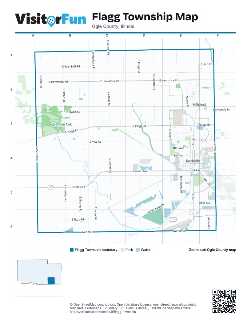
Street index of Flagg Township
Each street on the sheet and the grid squares it crosses.
- East Grist Mill RoadA1, B1, C1
- South Knoll RoadA1, A2, A3
- South Skare RoadB1, B2, B3, B4
- South Center RoadC1, C2, C3, C4, C5
- South White Rock RoadC1, C2
- South Kings RoadD1, D2
- South Queens RoadD1, D2, D3
- East Lind RoadE1, F1
- East Hemstock RoadA2, B2, C2, D2, E2
- Oak Ridge DriveA2
- East Kuehl CourtB2, B3
- South Richard RoadB2, B3
- Elliott DriveE2
- Erickson RoadE2, E3
- Errett RoadE2, E3
- Gale CourtE2
- Hillcrest AvenueE2, F2
- Leeward LaneE2
- Linda AvenueE2
- Maple AvenueE2, F2
- Maple CourtE2
- Moluf DriveE2
- OakE2
- Oak AvenueE2, F2
- Powers RoadE2, F2, E3
- Ramona AvenueE2
- River RoadE2, E3
- Rosalind RoadE2
- Roy AvenueE2
- Wayne RoadE2, E3
- Windmill CourtE2
- Windmill DriveE2
- Windover Park CourtE2
- Windover Park DriveE2
- Windward CourtE2
- Windward LaneE2
- East Flagg RoadA3, B3, C3, D3, E3
- East Fowler RoadA3, B3, C3
- Marquand DriveA3, B3
- Skare Park RoadA3, B3
- South Meridian RoadA3, A4
- Branch CourtB3
- Branch RoadB3
- Centerview DriveB3, B4
- Clara AvenueB3
- Deer Creek LaneB3
- East Deer Creek LaneB3
- East Hickory Ridge DriveB3
- East Raindance DriveB3
- Elizabeth TerraceB3
- Shagbark LaneB3
- Skare CourtB3
- South Brooklyn RoadB3, B4, B5, B6
- South Indian TrailB3
- South Park Place DriveB3
- South Skare CourtB3
- South Wildflower DriveB3
- East Birkley AvenueC3
- East Cottonwood CourtC3
- East Willow CourtC3
- South Brookstone DriveC3
- South Mill Pond RoadC3
- South Shady PassC3
- Sunnydale LaneC3
- Sunset LaneC3
- Beebe DriveD3
- Corey LaneD3
- East Carriage RoadD3
- East Meadowland DriveD3
- East Orchard Hills DriveD3
- Field CourtD3
- North Rolling Green LaneD3
- South Forester DriveD3
- South Greenland DriveD3
- South Prairieland CourtD3
- West Meadowland DriveD3
- West Orchard Hills DriveD3
- 20th StreetE3, E4
- 8th StreetE3, E4
- Carrie AvenueE3
- Clifton TerraceE3, E4
- East Rose AvenueE3
- East Twombly RoadE3, F3
- East Wayne AvenueE3
- Fairview DriveE3
- Fenny CourtE3
- Flagg RoadE3, F3
- Forest CourtE3
- Gehant CourtE3
- Highland RoadE3
- Jeffery AvenueE3
- Joanne LaneE3, E4
- JonesE3
- Lincoln HighwayE3, E4
- May Mart DriveE3, F3
- McCall CourtE3
- North 14th StreetE3, E4
- North 7th StreetE3, E4
- North 9th StreetE3, E4
- North Eighth StreetE3
- Northfield CourtE3
- Northlake CourtE3
- Pickwick DriveE3
- Scott AvenueE3
- Short CourtE3
- South Harlan DriveE3
- South Wendell DriveE3
- Stoneridge TerraceE3
- Sunnymead DriveE3, F3
- Sunset TerraceE3
- Tilton Manor DriveE3
- Westgate CourtE3
- Brookside DriveF3
- Calvin RoadF3, F4
- Caron RoadF3
- Coronado DriveF3
- Crest LaneF3
- Currency CourtF3
- North Caron RoadF3, F4
- North Knoll DriveF3
- Ridge RoadF3
- Springdale DriveF3
- Turkington TerraceF3, F4
- Delct AvenueB4
- Delcy AvenueB4
- Delcy DriveB4
- Diane DriveB4, C4
- East Kyte RoadB4, C4, D4
- HawthorneB4
- Hawthorne TrailB4
- James DriveB4, C4
- Marcie LaneB4, C4
- Marie laneB4
- South Judy LaneB4
- South Woodland DriveB4, C4
- Tracy DriveB4
- Westwood AvenueB4
- East Fisher RoadC4
- East Lincoln LaneC4
- East Oak CourtC4, C5
- Honeysuckle LaneC4, C5
- Joanne AvenueC4
- Lilal LaneC4, C5
- Lincoln AvenueC4, D4, E4, A5, B5, C5
- Snapdragon LaneC4, C5
- South Klondike RoadC4, C5
- South Sarah AvenueC4
- Sunflower LaneC4, C5
- West StreetC4, C5
- Centerpoint DriveD4
- South Brush Grove RoadD4, D5, D6
- 10th AvenueE4, F4
- 16th StreetE4
- 1st AvenueE4, F4
- 2nd AvenueE4, F4
- 4th AvenueE4, F4
- 5th AvenueE4, F4
- 6th AvenueE4, F4
- 7th AvenueE4, F4
- 8th AvenueE4, F4
- 9th AvenueE4, F4
- Avenue AE4
- Avenue BE4, E5
- Cherry AvenueE4, F4
- High School StreetE4
- Jack Dame DriveE4, E5
- Knights LaneE4
- North 10th StreetE4
- North 11th StreetE4
- North 12th StreetE4
- North 15th StreetE4
- North 6th StreetE4
- North Main StreetE4
- North Washington StreetE4
- Page WayE4
- South 10th StreetE4, E5
- South 11th StreetE4
- South 12th StreetE4, E5
- South 6th StreetE4
- South 7th StreetE4, E5
- South 9th StreetE4, E5
- South Main StreetE4, F4, F5
- South Washington StreetE4
- Squires LandingE4
- Tilton Park DriveE4
- West McConaughy AvenueE4, F4
- Westview DriveE4
- Woolf CourtE4
- Avenue CF4
- Avenue DF4, F5
- Avenue EF4, E5, F5
- Avenue GF4, F5
- Carlisle DriveF4
- Drake AvenueF4
- Eagle DriveF4
- East McConaughy AvenueF4
- Kelley DriveF4
- Linder LaneF4
- Meadow LaneF4
- North 1st StreetF4
- North 2nd StreetF4
- North 3rd StreetF4
- Parkview DriveF4
- Popular RoadF4
- School AvenueF4
- South 2nd StreetF4, F5
- South 3rd StreetF4, F5
- South Caron RoadF4
- South Koch RoadA5
- East Thorpe RoadB5, C5
- South Grange RoadB5, B6
- East Titus RoadC5, B6, C6
- Orchid LaneC5
- South Thorpe RoadC5, C6
- Intermodal DriveD5, E5, D6
- Cleveland AvenueE5, F5
- Cove CircleE5
- Eliot DriveE5
- Garfield DriveE5
- Gary AvenueE5
- Irene AvenueE5, F5
- Lake Lida LaneE5, F5
- Lakeview DriveE5
- Phyllis AvenueE5, F5
- Standard Oil RoadE5, F5
- State Route 251E5, E6
- Treatment Plant RoadE5
- Willis AvenueE5, F5
- Aigner ParkwayF5
- Cedar BridgeF5
- Dennis StreetF5
- East Avenue HF5
- Janet AvenueF5
- Lakeland DriveF5
- Quarry RoadF5
- Randall RoadF5
- Ronald Reagan Memorial TollwayF5, D6, E6, F6
- Shirley AvenueF5
- South 1st StreetF5
- Southview DriveF5
- West Avenue HF5
- Wood StreetF5
- East Gurler RoadB6, E6, F6
- Gurler RoadB6, C6, E6, F6
- Thorpe RoadC6
- East Steward RoadE6, F6
- Gurler Grove CourtE6
- State Route 251 / Illinois Route 251E6
- Alpha RoadF6
- South Lynn StreetF6
- Steward DriveF6
Places on the map
- 102.3 The Coyote - WYOT FM
- Aldi
- Atwood Park
- Auto Hub
- AutoZone
- Body Werks of Rochelle Inc
- Case IH Farming Equipment Dealer
- Central Elementary School
- Cooper Park
- Drexler Park
- First Baptist Church
- First General Baptist Church
- First United Presbyterian Church
- Flagg Center Cemetery
- Flagg-Rochelle Public Library
- Flannigan Park
- Gilbert Automotive
- Global III Intermodal Facility
- Helms Park and Athletic Complex
- Hillcrest
- Hillcrest Motel
- Kennay Farms Distilling
- Kwik Star
- Lawnridge Cemetery
- Lincoln Manor Senior Housing of LSSI
- Liquor & Wine
- Living Water Community Church
- Love's
- Love's Travel Stop
- May Elementary School
- Memorial Park
- Rochelle
- Rochelle City Hall
- Rochelle Community Hospital
- Rochelle Country Club
- Rochelle Municipal Airport
- Saint Patrick's Cemetery
- Skare Park
- Tilton Park
- V F W Park
© OpenStreetMap contributors, Open Database License, openstreetmap.org/copyright · Map data: Protomaps · Boundary: U.S. Census Bureau, TIGER/Line Shapefiles 2024















