

Illinois map
Freeport map
About 23,140 people live here (Census Bureau, 2024 estimate). The sheet's index lists 300 streets; South Adams Avenue, West Stephenson Street and North West Avenue cross the most grid squares. Also on it: Krape Park, Park Hills Golf Course and Stephenson County Fairgrounds.
Open the map (PDF, US Letter)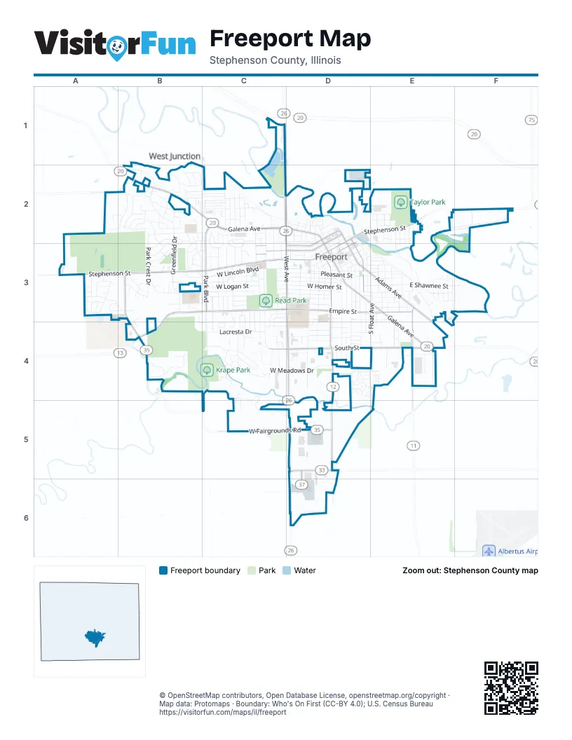
Street index of Freeport
Each street on the sheet and the grid squares it crosses.
- South West AvenueD3, D4
- South Adams AvenueD2, D3, E3, E4
- North West AvenueC2, D2, D3
- West Douglas StreetD2, C3, D3
- East Stephenson StreetD2, E2, D3
- West South StreetC4, D4
- East South StreetD4, E4
- West Clark StreetD2, C3, D3
- South Liberty AvenueD2, D3
- East Main StreetD2, D3
- North Adams AvenueD2
- East Clark StreetD2
- US 20 BusinessE4
- West Galena AvenueB2, C2, D2
- West Empire StreetC3, D3
- South Galena AvenueD3, E3, E4
- West Pearl City RoadB3, C3, B4
- East Empire StreetD3, E3
- North Galena AvenueD2, D3
- West Stephenson StreetA3, B3, C3, D3
- South Walnut RoadD4, D5, D6
- West Fairgrounds RoadC5, D5
- South Walnut AvenueD3, D4
- Kiwanis DriveB3, B4
- North Park BoulevardC2, C3
- West Lamm RoadD5
- South Forest RoadB4
- South Armstrong AvenueE3, E4
- South Park BoulevardC3
- South Baileyville RoadE4
- Industrial DriveD5, D6
- Sega DriveD6
- West Lily Creek RoadB2
- West Lincoln BoulevardC3, D3
- West American StreetC3, D3
- Woodside DriveC4, C5, D5
- South Chicago AvenueD3, D4
- North Greenfield DriveB2, B3
- West Pleasant StreetC3, D3
- East Shawnee StreetD3, E3, F3
- South Float AvenueE3, E4
- Park BoulevardC3, B4, C4
- West Meadows DriveC4, D4
- South Locust AvenueD3, D4
- South Oak AvenueD3, D4
- South Carrol AvenueD3, D4
- South Burchard AvenueC3, C4
- South Park RoadB4, C4, C5
- South Blackhawk AvenueD3, D4
- South State AvenueD3
- Park Crest DriveB2, B3
- South Hancock AvenueE2, E3
- South Demeter DriveC3, C4
- West Homer StreetC3, D3
- West Marvin LaneB4
- Knollwood DriveD4
- West Harrison StreetB3, C3
- West Cleveland StreetC4, D4
- West Avon StreetC3, D3
- Lacresta DriveC4
- West Elk StreetC3, D3
- South 18th AvenueE3, F3
- West Loras DriveA3, B3
- Winter DriveC2, C3
- South Harlem AvenueC3, C4
- West Chestnut StreetC3, D3
- West Logan StreetC3
- West Laurel StreetB2, C2
- East Pleasant StreetD3, E3
- South Benson BoulevardC3, C4
- East Jackson StreetE2, D3
- West Stover StreetC3
- South Benton AvenueD3
- East Iroquois StreetD3, E3
- South McKinley AvenueC3
- South Miami AvenueE3
- South Saxby AvenueC3
- West Mosley StreetD3
- North Henderson RoadE2
- South Cherry AvenueD3
- North Ridge DriveB2, C2, B3
- West Garfield StreetD4
- South Stewart AvenueC3
- Gladewood DriveC4
- Midwest CourtD4
- North Waddell AvenueC2
- West Middlebury RoadB2, B3
- North Westwood AvenueB2, B3
- Rosenstiel DriveD4
- East Jefferson StreetD3, E3
- Revere StreetB2, B3
- West Cottonwood StreetC2, D2
- Empire CourtC3, C4
- East Wyandotte StreetD3, E3
- West Broadway StreetD3
- Winchester DriveB2
- South Arcade AvenueE3
- Alamo DriveB2
- Sylvan CourtC4
- Crestwood DriveC2, C3
- South Dirck DriveC4
- North Walnut AvenueD2, D3
- North Warren AvenueC2
- East Winneshiek StreetD3, E3
- North Brewster AvenueC2
- North Riverside DriveC1
- South Greenfield DriveB3
- North Harlem AvenueC2, C3
- West Ringold StreetD2
- West Demeter DriveC4
- North Hunt AvenueC2
- Park Lane DriveC3, D3
- Barley Ridge TrailB2
- South High AvenueD3, D4
- North Van Buren AvenueD2, D3
- North Whistler AvenueC2, C3
- Shimer DriveA3
- North Foley AvenueC2, C3
- North Turner AvenueC2
- East Garden StreetE3
- Bedford RoadB3
- Farmdale LaneB2
- West Main StreetD3
- Concord DriveB2, B3
- Terra West DriveB3
- West Greenfield DriveB2
- Lincoln DriveE4
- South Pine AvenueD3
- East Winslow StreetD3, E3
- West Staver StreetC2
- South Carthage DriveA3
- Countryside LaneB2
- Canterbury DriveB3
- Valleyview DriveB3, C3
- Hillcrest DriveC4
- West Beach StreetC2
- Santa Fe DriveB2
- South Ottawa AvenueE3
- West Exchange StreetD3
- Willow AvenueB2
- Cimarron DriveB2
- South Maple AvenueD3
- East Center StreetE3
- East Washington StreetD3
- West Becker School RoadD6
- West Church StreetB3, C3
- South Bidwell AvenueE3, E4
- West Spring StreetD3
- Bolkinwood DriveC4
- South 16th StreetE3
- South 17th StreetE3
- Oakhill DriveC4
- Navajo DriveB3
- Country CourtB2
- East la Salle StreetE3
- West Kunkle BoulevardA3, B3
- South Van Buren AvenueD3
- North Bailey AvenueC3
- Highland DriveB3, C3
- Clinton PlaceE3
- South Chippewa AvenueE3
- South Rawleigh AvenueE4
- Brad Mar DriveA3
- West Roosevelt StreetD4
- South Highland AvenueD4
- South Kenwood AvenueE3
- West Dewey StreetD4
- East Spring StreetD3
- Evelyn AvenueC2
- West Evelyn StreetD3
- South Hance DriveC4
- Deming AvenueC3, C4
- East Illinois StreetE3
- Valley Rose DriveD4, E4
- West Jefferson DriveC3, D3, C4
- North Stewart AvenueC3
- South 15th AvenueE3
- North Mesa DriveB2
- Grant StreetE4
- Youngs LaneD4
- Sioux DriveB2
- South Ihm BoulevardE4
- Vista DriveD4
- Avenue BC2
- East Pershing StreetD4, E4
- Wheatland TerraceB2
- Avenue AC2
- Pleasant LaneC2
- Avenue DC2
- Hillview LaneC2
- South Louis AvenueE2
- Mulberry LaneC2
- Carriage Hill LaneC3, C4
- South Rotzleh AvenueE3, E4
- East Crocker StreetE2
- East Park StreetE2
- Marion AvenueB2
- North Sunset AvenueC3
- East de Leon StreetE3
- South Fruit AvenueE3
- West Factory StreetD4
- Structo RoadF2
- Woodside TerraceC5, D5
- South Mary AvenueE2, E3
- Barbury CircleB4
- Mark DriveC2
- East Album StreetE2, E3
- North Bellaire AvenueB2, C2, B3
- Wild Oats TrailB2
- North Wise AvenueC3
- Monroe DriveC3, C4
- Katherine DriveA3
- North Grove AvenueD2, D3
- West Lynn StreetC2
- North Powell AvenueC2, C3
- West Parkview DriveB3
- Winnefred StreetD3
- Avenue CC2
- North Mernitz AvenueC3
- South Beaver AvenueD3
- East Exchange StreetD2, D3
- North Chicago AvenueD2, D3
- Arapaho DriveB2
- South Johanna AvenueE2, E3
- County FairgroundsD5
- Viola DriveB2, C2
- Island AvenueC2
- Lorraine DriveB2, C2
- North Canyon DriveB2
- North Wilber AvenueE2
- Helen DriveB2, C2
- Meadowbrook LaneC4
- North Sheridan AvenueE2
- West Lancaster RoadD2
- Elizabeth CircleC3
- South Baxter LaneA3
- Sierra DriveB2
- West Iroquois StreetD3
- South 14th AvenueE3
- Country Club LaneB4, C4
- West Ordway StreetC2, D2
- South Prairie AvenueC3
- South Hooker AvenueE2, E3
- South Seeley AvenueC3
- North Cherry AvenueD2, D3
- Quail Ridge DriveB2
- Ridgefield DriveB3, B4, C4
- Leafwood DriveE4
- Marcia DriveB2, C2
- West Jackson StreetD3
- South School AvenueC3
- City StreetC2
- Jodilyn CircleB2
- South Homestead AvenueC3
- South Sleezer Home RoadE4
- West Elm StreetC2
- West Apache TrailB2
- Appaloosa DriveB2
- Berrywood DriveE4
- Tanglewood DriveD4
- Seminole DriveB3
- Towne DriveA3
- North Trunck AvenueC2
- West Hamilton StreetC4, D4
- Sandy Pointe DriveA2, B2
- West Violet StreetC3
- West Palmer StreetC3
- East Orin StreetE2
- East Monterey StreetD2
- North Westview RoadC2
- Hillcrest LaneC2, C3
- South Howard AvenueE2, E3
- West Hurd StreetC3
- West Summit StreetD2
- North Brick AvenueD2
- Knox DriveA3
- South Harvey AvenueC3
- North Louis AvenueE2
- East Adams AvenueE3
- Church StreetB3
- North Lemon AvenueD2
- Lawn PlaceC4
- South Cedar AvenueD4
- Rye Ridge TrailA2, B2
- North Island AvenueC2
- Commercial AvenueD2
- East Madison StreetE3
- South Rogers AvenueB3
- West Canyon DriveB2
- North Hardin AvenueD2
- Daren DriveA3
- Highland View DriveB3, B4
- South Columbia AvenueE3
- North Adelbert AvenueE2
- West Alsop StreetD2
- Singer DriveE3, E4
- Fieldcrest DriveD4
- South Sheridan AvenueE2
- Fawndale DriveD4
- West Carthage DriveA3
Places on the map
- 1st Stop
- 4 Seasons Bowling
- A+ Automotive Inc.
- Aaron's
- Advance America
- ALDI
- Applebee's
- AutoZone
- Beltline Cafe
- Benchwarmers
- Bethany United Church of Christ
- Blackhawk Elementary School
- Blain's Farm & Fleet
- Boss Carpet One Floor & Home
- Carl Sandburg Middle School
- Central Fire Station
- Christian Supply Center
- Cimino's Little Italy
- Compeer Financial
- Cork & Keg Liquors
- Cornerstone Credit Union
- Country Junction
- Freeport City Cemetery
- Freeport High School
- Freeport Middle School
- Freeport Wetland Preserve
- Krape Park
- Lincoln Mall
- Menards
- Oakland Freeport Cemetery
- Park Hills Golf Course
- Pecatonica Prairie Trail
- Read Park
- Saint Marys Cemetery
- Stephenson County Fairgrounds
- Taylor Park
- U.S. Bank
- Walmart Supercenter
- Winter Park
Next to Freeport
- West Junction
© OpenStreetMap contributors, Open Database License, openstreetmap.org/copyright · Map data: Protomaps · Boundary: Who's On First (CC-BY 4.0); U.S. Census Bureau















