

Illinois map
McHenry County map
About 315,959 people live here (Census Bureau, 2024 estimate). The sheet's index lists 65 streets; Main Street, Greenwood Road and State Route 23 cross the most grid squares. Also on it: 1.0 Mile Loop, Abbey Ridge and Adams Commercial Centre.
Open the map (PDF, US Letter)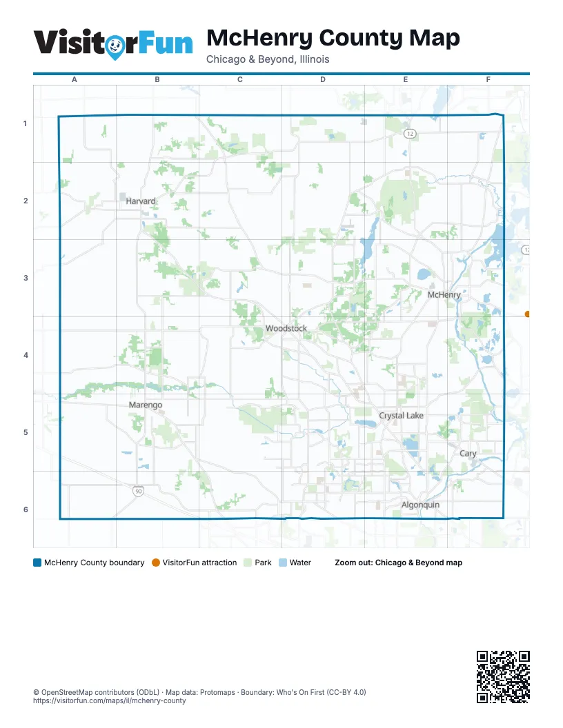
Street index of McHenry County
Each street on the sheet and the grid squares it crosses.
- North Division StreetB1, B2
- Maple AvenueC1, D1
- Greenwood RoadD1, D2, D3
- Main StreetD1, E1, D2, D3
- State Highway 120D1
- Burlington RoadE1
- Kenosha RoadE1, F1
- Kenosha StreetE1
- North Main StreetE1
- West IL Route 173F1
- West Wilmot RoadF1
- Wilmot RoadF1, F2
- Hunter RoadA2
- White Oaks RoadA2
- East Diggins StreetB2
- South Division StreetB2, B3
- State Route 23B2, B3, B4
- State Routh 23B2
- West Brink StreetB2
- Richmond RoadE2, E3
- West Washington StreetC3, D4
- McHenry AvenueD3, D4
- North Seminary AvenueD3, D4
- State Route 120D3, E3
- Front StreetE3
- South Front StreetE3, E4
- West Elm StreetE3, F3
- Elm StreetF3
- Rand RoadF3
- West Belvidere RoadF3
- North State StreetB4, B5
- North Madison StreetD4
- Northwest HighwayD4, E5, F5
- South Eastwood DriveD4, D5
- South State Route 31E4, E5
- East State RoadF4
- Roberts RoadF4, F5
- West State RoadF4, E5
- Jane Addams Memorial TollwayA5, A6, B6
- West Grant HighwayA5, B5
- East Grant HighwayB5, C6
- South State StreetB5, B6
- Telegraph StreetB5
- East Terra Cotta AvenueE5
- James R Rakow RoadE5
- North Randall RoadE5, E6
- North Virginia StreetE5
- South Virginia StreetE5
- West Terra Cotta AvenueE5
- West Virginia StreetE5
- South Northwest HighwayF5, F6
- West Roberts RoadF5
- U.S. Grant Memorial HighwayC6
- Algonquin RoadD6, E6
- West Algonquin RoadD6, E6
- Algonquin BypassE6
- East Algonquin RoadE6, F6
- Hanson RoadE6
- Randall RoadE6
- South Main StreetE6
- South Randall RoadE6
- Lake Cook RoadF6
- State Route 22F6
- West County Line RoadF6
- West Northwest HighwayF6
Places on the map
- 1.0 Mile Loop
- Abbey Ridge
- Adams Commercial Centre
- Alden-Sedge Meadow Conservation Area
- Algonquin
- Algonquin Pit #5
- Arbor Hills Park
- Barber Fen
- Bates Fen Nature Preserve
- Bay View Farm
- Beck's Wood
- Blackstone Golf Club
- Boger Bog Conservation Area
- Boloria Meadows
- Boone Creek
- Boone Creek Conservation Area
- Boone Creek Golf Course
- Boone Valley
- Boulder Ridge Country Club
- Brittany Heights
- Brittany Park
- Brookdale Conservation Area
- Bull Ridge
- Bull Valley
- Bull Valley Golf Club
- Burton Township
- Bystricky Prairie
- Cambria
- Camp Lakota
- Candlewood Trails
- Cary
- Cary Country Club
- Cary Lake
- Cary-Grove Park
- Chapel Hill Country Club
- Chapel Hill Oaks
- Chicago Northwest KOA
- Clavey's Nursery Inc
- Coachlight Ridge
- Cold Springs Park
© OpenStreetMap contributors (ODbL) · Map data: Protomaps · Boundary: Who's On First (CC-BY 4.0)