

Illinois map
Oswego map
About 60,581 people live here (Census Bureau, 2024 estimate). The sheet's index lists 300 streets; Wolf's Crossing Road, Douglas Road and 5th Street cross the most grid squares. Also on it: Andover Park, Bartlett Prairie & Wetland and Bluegrass Park.
Open the map (PDF, US Letter)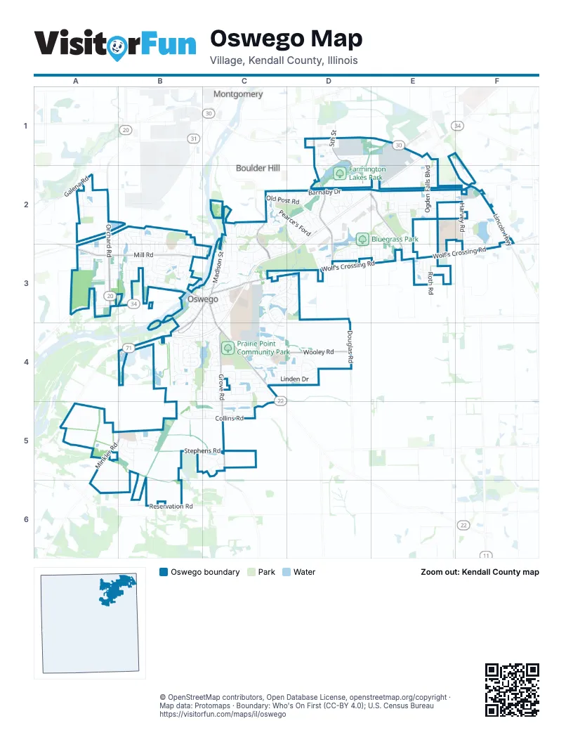
Street index of Oswego
Each street on the sheet and the grid squares it crosses.
- Orchard RoadA2, A3, B4
- Lincoln HighwayF2
- Ogden AvenueE1
- Wolf's Crossing RoadF2, C3, D3, E3, F3
- Plainfield RoadC4
- Chicago RoadC3
- West Washington StreetB3, C3
- Madison StreetC3
- Galena RoadA2
- Douglas RoadD1, D2, D3, D4
- 5th StreetD1, D2, E2, E3
- Grove RoadC4, C5
- Mill RoadA3, B3, C3
- Wooley RoadC4, D4
- Harvey RoadF2, F3
- Boulder Hill PassC2, C3
- Minkler RoadB4, A5, B5
- North Madison StreetC2, C3
- South Madison StreetB3, C3, B4
- Reservation RoadB6
- Douglas StreetB3, B4
- East Washington StreetC3, C4
- Goodwin DriveE1
- Bluegrass ParkwayD2, E2, D3
- Ogden Falls BoulevardE1, E2
- Southbury BoulevardC3, D3, C4
- Collins RoadB5, C5
- Yoakum BoulevardE2
- Colchester DriveC3, C4, D4
- Prairieview DriveB4, C4
- Linden DriveC4, D4
- Morgan Valley DriveB4, C4, C5
- Stone Hill RoadC3, C4
- Grape Vine TrailA2
- Barnaby DriveD2
- Kensington DriveD1, D2
- Fox Chase Drive NorthB2, B3
- Ashlawn AvenueC2, C3
- Devoe DriveF2, F3
- Kendall Point DriveD1, E1, E2
- Old Post RoadC2, D2
- Station DriveA2, A3
- Treasure DriveE2, F2
- Sudbury CircleB5, C5
- Churchill LaneB4
- Pearce's FordC2, D2
- Stephens RoadB5, C5
- Wiesbrook DriveD1
- Manhattan CircleB2
- Lakeview DriveC4
- Willowwood Drive NorthB2, B3
- Farmington Lakes RoadD2
- Roth RoadE3
- South Main StreetB3, C3, B4
- Chapin WayF2, F3
- Waterbury CircleE2
- Andover DriveC4
- Willington WayC3, D3
- Washington StreetB3
- Arboretum WayC4
- Paradise ParkwayB4
- Raintree DriveE2
- Bohannon CircleE2
- Orchard AvenueC3
- Bonaventure DriveE2
- Century DriveB2
- Cardinal AvenueD3
- Deerfield DriveC4
- Waubonsee Circle DriveD2
- Kirkland CircleE1, E2
- Arbor LaneB3
- Brockway DriveC2
- Hunt Club DriveB5
- Seton Creek DriveD2
- Heritage DriveD2
- Lombardy LaneC3
- North Adams StreetC3
- Isleview DriveC4, C5
- Chestnut DriveC5
- Monroe StreetB3, C3, B4
- Danbury DriveB4, C4
- Ashcroft LaneC4
- Dorset AvenueC4
- Foster DriveF2, F3
- Hemlock LaneC4, D4
- Juniper StreetD4
- Preakness DriveE2
- Vista DriveC4
- Chesterfield DriveC2, C3
- Northampton DriveC2, C3
- Waterford DriveC2
- Windsor DriveC4, C5
- Eisenhower DriveB3
- Burr Oak DriveB3
- McLaren DriveB5
- Litchfield WayC3, D3
- Blazing Star TrailD4
- Old Reserve RoadC5
- Truman DriveB3
- Wolverine DriveA2, B2, A3, B3
- Bellevue CircleE2
- Tuscany TrailA2
- Cascade LaneD2
- Otter WayB2
- Lincoln Station DriveE1, F1, F2
- River Mist DriveB3, C3
- Versailes ParkwayD2, E2
- Riesling RoadE3
- Preston LaneD3
- Presidential BoulevardB3
- Amherst CircleC4
- Schofield DriveB5
- Pineridge Drive NorthA2, A3
- Liszka LaneC4, D4
- Oaklawn AvenueC2, C3
- Concord DriveA2
- South Adams StreetB3, C3
- Millstream LaneB3
- Lakeshore DriveC3, C4
- Pine Ridge Drive SouthA3
- Springbrook Trail NorthD2
- Woodford TrailE2
- Willowwood DriveB3
- Milkweed DriveD4
- Templeton DriveC4
- Club House LaneA3
- Weaver StreetB5
- Bloomfield Circle WestC4
- Sherwick RoadC2
- Willowwood Drive SouthB3
- Gloria LaneD2
- Half Round RoadB5, C5
- Bison RoadB2
- Sedgwick RoadC2
- Persimmon LaneB4
- Badger LaneB3
- Stonemill LaneD2
- Parkside LaneB4
- Salem CircleD2
- Bucktail DriveA2, B2, B3
- Camden CircleB4, C4
- Heatherwood DriveA3
- Greenview LaneB3
- Bloomfield Circle EastC4
- Mondovi DriveD2
- Lewis StreetA3
- Bayberry DriveB3
- Judson StreetB3, B4
- Secretariat LaneE2, E3
- Carpenter AvenueB5
- East Benton StreetB3, C3, C4
- Fairfield DriveD3
- Stonewater LaneB3
- Fayette DriveD3
- Carnation DriveB4
- Alley CE2
- Clearwater LaneB3
- Ashland StreetC3
- Townsend DriveF2
- Briarwood LaneC4
- Robert RoadC3
- Wilson PlaceB3, C3, C4
- Millersburg StreetE2
- River Run BoulevardB3
- Park StreetC3
- East Jackson StreetC3
- Barbera DriveE3
- Mansfield WayC3, D3
- Blue Ridge DriveE2
- Elmwood DriveC3
- Garfield StreetC3
- Forest AvenueB3, B4
- Beau Meade RoadC2
- Crofton RoadC2
- Essex DriveE2
- Claridge DriveC4
- Majestic LaneE2, E3
- Seeley StreetB5
- Fawn DriveB2, B3
- Ebony DriveE2, E3
- Fox Chase Dr SB3
- Franklin StreetC3
- Long Beach RoadD1, D2
- Jessamine DriveD3, E3
- Belmont AvenueD3, E3
- Winthrop DriveC3, D3
- Bickford AvenueB5
- Semillon StreetE3
- Stone Gate DriveC3
- Charolotte LaneC2, D2
- Deerpath DriveB3
- Oakwood DriveC3
- Terrace LaneB4
- Mitchell DriveF2
- Ash Grove LaneB3
- Grays DriveD2
- Pimlico StreetE2
- Westford PlaceD4
- Springbrook Trail SouthD2
- Julep AvenueD3
- Wingate DriveE2
- Goldenrod DriveB5, C5
- Nottingham DriveC2, C3
- Tewksbury CircleC2, C3, D3
- Concord Drive SouthA2
- Loradale RoadE2
- Newport CircleD2
- Beaver CrossingB3
- Rosebush LaneB4
- Sonoma Trails DriveE3
- Cinderford DriveC3
- Matena DriveD2
- Mustang DriveC4, C5
- Bower LaneD3
- Bodega RoadE3
- Angela CircleC2
- Buttonbush LaneD4
- Migration StreetD4
- Laughton AvenueA5, B5
- Northgate CircleB4
- Theodore DriveC4
- Parker PlaceF2, F3
- Butler StreetB5
- Partridge SquareC3
- Hackney LaneC5
- Dancer LaneE2, E3
- Alder DriveA3, B3
- Canton DriveC3
- Judith CircleC2
- East Tyler StreetB3, C3
- Valentine WayF2, F3
- Gates Creek DriveB3
- South Harrison StreetB3
- Georgetown DriveD3, E3
- Vinca LaneC4
- Norway PlaceB3
- Berrywood LaneA3
- Lennox DriveB2, B3
- Thimbleweed DriveD4
- Columbus DriveB2
- Hickory StreetB4, C4
- Polk StreetC3
- Della LaneC3
- Hawley DriveF2
- West Jefferson StreetC3
- Woodland WayC4
- West Jackson StreetB3, C3
- Ferret CrossingB2
- Cebold DriveC2
- Whitetail CrossingB3
- Wollmington DriveD2
- Plank DriveC4
- Richmond DriveD2
- Pinehurst LaneC4
- Reagan DriveB3
- West Benton StreetB3
- Holly LaneA3
- Whitewater LaneB3
- Blue Heron DriveC5
- Jefferson StreetC3
- Charismatic DriveE3
- Alley AE2
- Taft DriveB3
- Bentson StreetB3
- Chesapeake LaneE3
- Marty LaneC4
- Wilmette AvenueC4
- Cornell DriveD2
- Greenwood PlaceC4
- Stoneleigh LaneD2
- Northgate DriveB4
- Hoover DriveB3
- Frankfort AvenueD3
- Queen DriveE2
- Spruce DriveB3
- Victoria LaneC2, D2
- Primrose LaneE2
- Meadowwood LaneA3
- Baden AvenueE3
- Redwood BoulevardA3, B3
- Mill Road CourtB3, C3
- Roosevelt DriveB3
- White Oak DriveA3
- Torrington CourtC3
- Bednarcik CourtC3
- Barton DriveD3
- Thornbury DriveC3
- Blossom LaneB4
- Woodchuck TrailB2
- Windcrest DriveC3
- Ridgefield RoadC2
- Wingate CourtE1, E2
- Coventry CourtB3
- Stillwater CourtB3
- Bridgeview DriveE2
- Pfund CourtC3
- Homeview DriveE2
- White Pines CourtC4
- Ashley CourtD2
- Circle Drive WestC2
Places on the map
- Andover Park
- Bartlett Prairie & Wetland
- Bluegrass Park
- Bristol 3
- Chesterfield Lake
- Chesterfield Park
- Civic Center Park
- East View Academy
- Farmington Lakes Park
- Fox Bend Golf Course
- Fox Chase Elementary School
- Fox River Islands
- Hudson Crossing Park
- Hunt Club Elementary School
- Hunt Club Prairie Wetland
- Lake Douglas
- Northampton Greenway
- Old Post Park
- Oswego 10
- Oswego 11
- Oswego 13
- Oswego 17
- Oswego 2
- Oswego 20
- Oswego 21
- Oswego 22
- Oswego 24
- Oswego 26
- Oswego 28
- Oswego 29
- Oswego 3
- Oswego 30
- Oswego 31
- Oswego 32
- Oswego 33
- Oswego 4
- Oswego East High School
- Oswego High School
- Prairie Point Community Park
- Waubonsie Wetland
Next to Oswego
- Boulder Hill
- Montgomery
© OpenStreetMap contributors, Open Database License, openstreetmap.org/copyright · Map data: Protomaps · Boundary: Who's On First (CC-BY 4.0); U.S. Census Bureau