

Illinois map
Oswego Township map
About 60,581 people live here (Census Bureau, 2024 estimate). The sheet's index lists 300 streets; Collins Road, Douglas Road and Plainfield Road cross the most grid squares. Also on it: Arranmore Farm and Polo Club, Bluegrass Park and Boulder Hill.
Open the map (PDF, US Letter)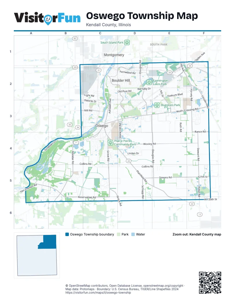
Street index of Oswego Township
Each street on the sheet and the grid squares it crosses.
- Ogden AvenueF1, E2, F2
- Lincoln HighwayE2, F2, F3
- Hill AvenueE1, E2
- Orchard RoadB4
- Wolf's Crossing RoadC3, D3, E3, F3
- Plainfield RoadC4, D4, D5, E5, E6
- Chicago RoadC3
- West Washington StreetC3
- Madison StreetC3
- South Lake StreetC1
- Douglas RoadD1, D2, D3, E3, E4, E5
- Wooley RoadC4, D4, E4, F4
- Reservation RoadA5, B5, C5, B6, C6
- Minkler RoadB4, B5, B6
- Grove RoadC4, C5, D6
- 5th StreetD1, D2, E2, E3
- Boulder Hill PassC2, D2, D3
- Ridge RoadF5, F6
- Harvey RoadF2, F3
- Stewart RoadF3, F4, F5
- Simons RoadD5, E5, F5
- Briarcliff RoadD1, C2, D2
- Goodwin DriveE1, E2
- Schlapp RoadD5
- Mill RoadB3, C3
- 127th StreetF5
- Caterpillar DriveB2, C2
- Van Emmon RoadA5
- North Madison StreetC3
- South Madison StreetC3, C4
- Rance RoadF3
- West Hafenrichter RoadF2
- West 135th StreetF6
- Douglas StreetC4
- East Washington StreetC3, C4
- 111th StreetF3
- Hafenrichter RoadF2
- Southeast River RoadC1
- Collins RoadB4, C4, B5, C5, D5, E5, F5
- Grande Park BoulevardF5, F6
- Bluegrass ParkwayE2, D3, E3
- Ogden Falls BoulevardE2
- Southbury BoulevardD3, D4
- Sundown LaneA4, B4
- Yoakum BoulevardE2
- Colchester DriveD3, D4
- Prairieview DriveC4
- Old Post RoadC2, D2
- Roth RoadE3, E4
- Lundquist DriveF2, F3
- Country RoadA5, B5
- Fernwood RoadC2, D2
- Circle Drive EastC2, D2
- Linden DriveD4
- Morgan Valley DriveC4, D4, D5
- Stone Hill RoadD3, D4
- Circle Drive WestC2, D2
- Barnaby DriveD2, E2
- Summerlin DriveF1, F2
- Old Reserve RoadC5
- Fields DriveA5, B5, A6
- Kensington DriveD2, E2
- Grande Poplar CircleF5
- Kendall Point DriveE2
- Stephens RoadC5
- Saugatuck RoadD2
- Fox Chase Drive NorthC3
- Ashlawn AvenueC2, C3
- Devoe DriveF2, F3
- Century DriveC3
- Treasure DriveE2, F2
- Sudbury CircleC4, C5
- Churchill LaneC4
- Timber Wood CircleF5
- South Main StreetC3, C4
- Pearce's FordD2, D3
- Garden DriveC2
- Wiesbrook DriveD2, E2
- Manhattan CircleB3, C3
- Lakeview DriveC4
- Silverleaf DriveF5
- Long Beach DriveD2
- Grande Pines BoulevardF5
- Farmington Lakes RoadD2, E2
- Piper Glen AvenueD3, D4
- Chapin WayF2, F3
- Waterbury CircleE2
- Andover DriveC4, D4
- Willington WayD3
- Washington StreetC3
- Winding Creek RoadA5, B5
- Arboretum WayC4, D4
- Light RoadB2, C2
- Oak Creek DriveB5
- Dolores StreetB2, C2, C3
- Paradise ParkwayC4
- Raintree DriveE2
- Bohannon CircleE2
- Orchard AvenueC3, D3
- East Base Line RoadB1, C1
- Bonaventure DriveE2, E3
- South Farnsworth AvenueF2
- Exit RoadA5
- Crestview DriveC5, C6
- Danforth DriveF3
- Cardinal AvenueE3
- Deerfield DriveC4, D4
- Waubonsee Circle DriveD2, D3
- Emerald DriveE1
- Kirkland CircleE2
- Marnel RoadD2
- Heritage DriveD2, E2
- Brockway DriveC2, D2, C3, D3
- Springdale RoadD2
- Ingleshire RoadD2
- Hunt Club DriveB5, C5
- Seton Creek DriveD2, D3
- Lombardy LaneC3, D3
- North Adams StreetC3
- Isleview DriveC4
- Chestnut DriveC5, D5
- Monroe StreetC3, C4
- Danbury DriveC4
- Ashcroft LaneC4, D4
- Madeline DriveA5, B5, A6
- Osage CourtC3
- Rourke DriveF2
- Thornwood BoulevardF5
- Dorset AvenueD4
- Foster DriveF3
- Hemlock LaneD4
- Keating DriveF1
- Juniper StreetD4
- Riesling RoadE3
- Preakness DriveE2, E3
- Vista DriveC4
- Barrington Drive WestF2
- Entrance DriveA5
- Red Apple RoadF5
- Chesterfield DriveD3
- Northampton DriveC3, D3
- Lindengate CircleF5, F6
- Hampton RoadC2, D2
- Wilson Creek CircleF2
- Waterford DriveD2, D3
- Audrey AvenueB5, A6, B6
- Sonora DriveD2
- Windsor DriveC4
- Eisenhower DriveC3
- Gilmore RoadF5
- Codorus RoadC2
- Timber Lane RoadD1, D2
- McLaren DriveB5, C5
- Litchfield WayD3
- Morning Mist PlaceF5, F6
- James Leigh DriveF2
- Blazing Star TrailD4
- Truman DriveB3, C3
- Basswood CircleF5, F6
- Bellevue CircleE2
- Peppertree DriveF5
- Bower LaneD3
- Cascade LaneD3
- Pembrooke RoadD2
- Lincoln Station DriveF2
- River Mist DriveC3
- Versailes ParkwayE3
- Preston LaneD3, D4
- Scotch RoadF4
- Henderson StreetF3
- South Devoe DriveF3
- Presidential BoulevardC3
- Amherst CircleD4
- Roaring Creek LaneF2
- Schofield DriveB5, C5
- Riverview CourtC3, B4
- North Bereman RoadC2
- South Bereman RoadC2
- Cherry Blossom BoulevardF5
- Burr Oak DriveB3, C3
- Liszka LaneD4
- Oaklawn AvenueC3
- Farnsworth AvenueF1, F2
- Heathgate RoadD2
- Leasure LaneD5
- Alberta AvenueD3
- South Adams StreetC3
- Millstream LaneC3
- Grand Point TrailF2
- Ione LaneF1
- Lakeshore DriveD3, D4
- Springbrook Trail NorthD2, E2
- Willowwood Drive NorthB3, C3
- Field Point RoadC2, D2
- Tealwood RoadD2
- Shadow Creek LaneA6
- Woodford TrailE2, E3
- Fredricksburg LaneF2
- Durango RoadC2, D2
- Tallgrass LaneB5
- Aldon RoadC2
- Milkweed DriveD4
- Templeton DriveC4, D4
- Hide Away LaneA5
- Fallcreek CircleD2
- Cayman DriveC2, D2
- Weaver StreetC5
- Hathaway LaneF3
- Bloomfield Circle WestD4
- Seneca DriveC2, D2
- Cherry DriveC3
- Sherwick RoadC2, C3
- Farnsworth RoadF1
- Gloria LaneD2
- Wildwood PlaceF5
- Ridgefield RoadD2
- Half Round RoadC5
- Seasons Ridge BoulevardD1
- Sedgwick RoadD2, D3
- Persimmon LaneC4
- Badger LaneC3
- Creek LaneA5
- Summerfield DriveF1
- Tinana StreetF3
- Commerce DriveB2, C2
- Diamond Creek LaneF2
- Lyndhurst LaneF2
- Stonemill LaneD2, D3
- Parkside LaneC4
- Conifer StreetF5
- Fairfield DriveD3
- Winrock RoadD2
- Salem CircleD2, E2
- Winter Hill CircleD1
- Laurie LaneC2, C3
- Camden CircleC4
- Conway LaneF1, F2
- Canyon Creek DriveF1, F2
- Greenview LaneC3
- Henry LaneD3
- Cebold DriveC2, C3
- Creek SideA5
- Bloomfield Circle EastD4
- Mondovi DriveD2
- River Bend RoadC1, D1
- Hamlet CircleD1
- Judson StreetC4
- Goldenrod DriveC5
- Vintage DriveE3
- Afton DriveD2
- Secretariat LaneE3
- Carpenter AvenueB5
- East Benton StreetC3, C4
- Emblem CircleF3
- Deer Run DriveD1, D2
- Stonewater LaneC3
- Fayette DriveD3, E3
- West Anchor RoadC2
- Carnation DriveC4
- Tomahawk TrailC6
- Alley CE2
- Lexington DriveD1
- Red Fox RunD1, D2
- Clearwater LaneC3
- Woodridge RoadC2, D2
- Eastfield RoadD2
- Ashland StreetC3
- Willowwood Drive SouthB3
- Townsend DriveF3
- Briarwood LaneC4
- Robert RoadD3
- Schmidt LaneB5, B6
- Wilson PlaceC3, C4
- Lake SideA5
- Millersburg StreetE2
- Baler AvenueF1, F2
- River Run BoulevardC3
- Park StreetC3
- Somerset RoadC2, D2
- West 119th StreetF4
- East Jackson StreetC3
- Northpoint DriveF1
- Alpine WayF5
- Barbera DriveE3
- Mansfield WayD3
- Blue Ridge DriveE2
- Elmwood DriveC3
- Garfield StreetC3
- Greenbriar RoadC2, D2
- Pleasant View DriveB3, C3
- Forest AvenueC4
- Danielle LaneA5, A6
- Pueblo RoadD2
- Beau Meade RoadD3
- Chesterfield LaneF2
- Poplar CrossingF5
- Hubbard RoadD2
- Pheasant RoadF3, F4
- Base Line RoadB1, C1, B2
- Crofton RoadD2, D3
Places on the map
- Arranmore Farm and Polo Club
- Bluegrass Park
- Boulder Hill
- Farmington Lakes Park
- Fox Bend Golf Course
- Fox Bluff
- Fox Ridge Stone
- Mo-Ah-Way Reservation
- Montgomery
- Ogden Hill of Montgomery
- Oswego 1
- Oswego 10
- Oswego 11
- Oswego 12
- Oswego 13
- Oswego 14
- Oswego 15
- Oswego 16
- Oswego 17
- Oswego 18
- Oswego 19
- Oswego 2
- Oswego 20
- Oswego 21
- Oswego 22
- Oswego 23
- Oswego 24
- Oswego 25
- Oswego 26
- Oswego 27
- Oswego 28
- Oswego 29
- Oswego 3
- Oswego 30
- Oswego 31
- Oswego 32
- Oswego 33
- Oswego 4
- Oswego 5
- Oswego 6
Next to Oswego Township
- Montgomery
- South Park
© OpenStreetMap contributors, Open Database License, openstreetmap.org/copyright · Map data: Protomaps · Boundary: U.S. Census Bureau, TIGER/Line Shapefiles 2024