

Illinois map
Roselle map
About 22,871 people live here (Census Bureau, 2024 estimate). The sheet's index lists 300 streets; Elgin-O'Hare Tollway, Irving Park Road and West Central Avenue cross the most grid squares. Also on it: Goose Lake Park, Lake Park High School West and Chatburg Park.
Open the map (PDF, US Letter)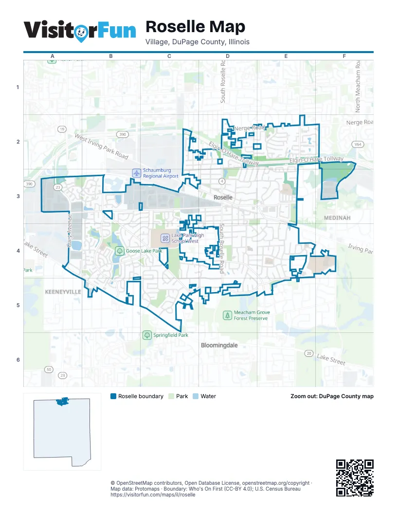
Street index of Roselle
Each street on the sheet and the grid squares it crosses.
- Elgin-O'Hare TollwayC2, D2, E2, F2
- West Lake StreetA4, B5, C5
- Lake StreetA4
- Gary AvenueA3, A4
- Irving Park RoadC3, D3, E3, E4
- North Roselle RoadD2, D3
- Nerge RoadD2, E2
- South Roselle RoadD2, D3, D4
- Medinah RoadF2, F3
- Elgin-O'Hare Frontage RoadF2
- West Central AvenueA3, B3, C3, D3
- West Bryn Mawr AvenueB4, C4, D4, B5
- Rodenburg RoadB3, B4, B5
- Mensching RoadB3, B4, C4, C5
- Foster AvenueE4, D5, E5
- North Plum Grove RoadE2, E3
- East Walnut StreetD4, E4, E5
- Rosedale AvenueC4, C5
- Lawrence AvenueE3
- South Plum Grove RoadE2
- South Walnut StreetE5
- North Circle AvenueE5
- East Granville AvenueD3, E3
- East Devon AvenueD2, E2, E3
- South Garden AvenueB3, B4
- West End RoadC3, C4, C5
- Maple AvenueC3, D3, E3
- Springhill DriveE4
- Pinecroft DriveE3, E4, E5
- Spring StreetD3, D4, D5
- Rush StreetD4
- South Prospect StreetD3, D4
- East Bryn Mawr AvenueD4, E4
- East Ardmore AvenueE3, D4, E4
- Travis ParkwayA3, B3
- Hill StreetD3, D4
- Forest AvenueC5, D5
- East Turner AvenueD4, E4
- Summerfield DriveC5
- Valley RoadC3, C4
- West Pine StreetC4, D4
- North Woodfield TrailE2
- Springfield DriveC4, C5
- Chatham LaneB3, B4
- East Pine AvenueD4, E4
- Sycamore AvenueE3, E4
- Edenwood DriveB4, C4
- Lincoln StreetD2, D3
- West Ardmore AvenueC4, D4
- Brittania WayA3, B3
- Main StreetD3, E3
- Yosemite TrailE2, F2
- Schreiber AvenueC2, D2
- East Thorndale AvenueD3
- Marion StreetD2, D3
- Picton RoadC5, D5
- Arthur AvenueC2, D2
- Sunnyside RoadE4
- Orchard TerraceD4, E4
- West Devon AvenueD2, C3, D3
- Pine AvenueB4, C4
- Waterbury LaneB4
- White Oak DriveE4
- Jennifer LaneD2, E2
- Borden DriveB3, D4
- Flamingo DriveB3
- Glendale RoadE4
- Garden AvenueB3, B5
- Heritage DriveC4, D4
- Locust LaneE4
- Larson LaneD2
- Albion AvenueC2, D2
- Cherry StreetE3
- West Maple AvenueC3, D3
- Park LaneD3
- North Prospect StreetD3
- Oak StreetD4, D5
- Congress Circle NorthC3
- Hunter DriveB3, C3
- North Garden AvenueB3
- Woodworth PlaceC4
- Howard AvenueD3, D4
- Willow StreetD3, D4
- Middleton DriveB4, B5
- East Woodworth PlaceD4
- Springwood DriveD2
- Park StreetD3, D4
- Longford DriveB3, C3, B4
- West Hattendorf AvenueD3
- Northampton LaneB4
- Catalpa AvenueD4, E4
- Half LaneD2
- Rosewood DriveC3, C4
- Claria DriveD3
- Siems CircleD4
- Radnor DriveB4, B5
- Cumberland TrailF2
- West Granville AvenueD3
- Berwick PlaceB4, B5
- Rosemont AvenueD3
- Indian Hill DriveD2
- Congress Circle WestC3
- West Glenlake AvenueD3
- Colby Commerce DriveA4
- Dee LaneE3
- Chancelor DriveC3
- East Hattendorf AvenueD3
- New Castle DriveC3
- Town Acres LaneD3
- Autumn DriveC4, C5
- Acacia LaneF4
- Sequoia TrailE2
- Briarwood LaneB4, B5
- Glacier TrailE2
- Logan StreetC2, C3
- Ashbury Lane WestB3
- Red Maple LaneC4, C5
- Seward StreetC2
- Woodside DriveB5
- Winterwood DriveC5
- Brandywine DriveB4, C4
- Dover DriveB4
- Windsor DriveC4
- Monaco DriveC3
- Andover DriveB3, B4
- Carlsbad TrailE2
- Crestwood DriveD4, D5, E5
- Stonehurst DriveB4, C4
- High Ridge RoadE3
- Ridgefield DriveC4
- South Park StreetD3, D4
- West Elm AvenueD3
- Stafford DriveB4
- Circle DriveE2, E3
- West Turner AvenueD4
- Bluebird LaneB3
- Case DriveB3, C3
- Lexington AvenueE4, E5
- East Woodfield TrailE2
- Forum DriveE2, E3
- Brower DriveB3
- Countryside DriveD2, D3
- East Elm StreetD3
- Hillside DriveD2, D3
- Williams StreetC3
- Morningside DriveE3
- Old Farm DriveC5
- Ambleside DriveE2, D3, E3
- Presidential DriveC3
- Dorchester CourtB4
- Grant StreetC2
- Berkshire TerraceD4, E4
- Ventura Club DriveE2, E3
- Fall CircleC5
- Prescott DriveB5
- Dave Pate DriveB3, C3
- Bryce TrailE2
- Stevenson CourtF3
- Washington StreetC2
- Lakeside DriveD2, D3
- Daisy LaneB4, B5
- Nassau DriveC4
- Rose Drive EastE3
- Carey DriveD2
- Avebury LaneC4
- Isle Royal BayE2
- Cross Creek Drive NorthE2, F2
- West Quincy DriveB4, C4
- Yosemite CourtE2
- Ashbury Lane EastB3
- Ash StreetE4
- David StreetD2, E2
- Winfield WayB3
- Terry DriveE3
- McWalter DriveD2
- Glenmore PlaceB4
- LoganC2
- Pelican BayB3
- Forest DriveD5
- Congress Circle SouthC3
- Leawood DriveC3, C4
- Keeney RoadB5
- Richmond DriveC3
- Norman LaneB4
- Darby LaneB4
- Hemlock LaneC4, C5
- Hampton LaneB4
- Merriford LaneA3, B3
- Walnut AvenueC4, E4
- Dalton LaneC4
- West Woodworth PlaceC4
- Meade LaneB5
- Acadia TrailE2
- Dinah RoadE4
- Newport SouthC5
- Crest AvenueE3, F3
- Newport NorthC5
- Shagbark LaneC4, C5
- Westminster CircleB4
- Brentwood CourtC5
- Country Lane SouthC5
- Country Lane NorthC4
- Colony LaneB4
- Cardinal LaneB3
- Walter DriveD3
- West Thorndale AvenueD3
- Webster AvenueE4
- May StreetD2
- Bobby Ann CourtA4
- Wildwood DriveC3
- South Monterey AvenueE2
- Brighton BayB4
- Hamstead CourtB4
- Thoroughbred LaneC3
- Rosner DriveE3
- Club House CircleE3
- Fordham PlaceB4
- Hygate DriveB3, B4
- Portwine DriveE3
- Roslyn RoadD2
- Thornfield LaneA3
- Greenbriar LaneE2
- Blackhawk DriveE2
- Pierce AvenueE4
- Algonquin DriveE2
- Lakeview CourtE3
- Blue Heron WayB3
- Glendale TerraceD5
- Frontier LaneD3
- Brookside DriveC3
- Spring CourtD4, F4
- Oxford PlaceB4
- Ryan WayA3
- West Walnut CourtD4
- Bokelman AvenueD3
- Singleton DriveB4
- Sunrise LaneC5
- Americana CourtB3
- Parkview CourtE3
- West Flamingo DriveB3
- Banbury TerraceE4
- Clearwater WestC5
- Overland TrailE2
- North Andover DriveB3
- Cambrian CourtB3
- Stockport CourtB4
- Kipling CourtE4, E5
- Century DriveE3
- Sunrise PlaceC5
- Chrisholm TrailE2
- Harvest LaneC5
- Clearwater NorthC5
- Greenwood CourtD5
- Sussex CourtB3
- Kennedy LaneC2
- Stonefield PlaceB4
- Acadia CourtE2
- Chatfield CourtA3, B3
- Hudson CourtC3, C4
- Cross Creek Drive WestE2
- Charlemagne CircleD4
- Brendon CourtA3
- Cross Creek CourtE2
- Stonehurst LaneB4
- Waterford CourtC3
- Salt Creek RoadE3
- White Sands BayE2
- Tiffany LaneC4, D4
- Deeke CourtB3
- Walnut Oaks DriveD4
- Sherwood CourtA3
- Chevoit CourtA3
- Mulford LaneB4
- Hastings CourtB3
- Kelly CourtB5
- Goodridge TerraceC5
- Turner AvenueE4
- Lake Pointe DriveE3
- Oregon TrailE2
- Norfolk CourtB3
- Birmingham CourtB3
- Winfield CourtB3
- Catino CourtD4
- Harvest PlaceC5
- Chatham CourtB4
- Cherry CourtE3
- East Glenlake AvenueD3
- Sheffield CourtB3
- Thornfield CourtA3
- Welland CourtB3
- Kensington CourtB4
- Lake Shore DriveE3
- Cypress CourtD5
- Eden CourtD2, E2
- Oxford CircleB4
- Tuppeny CourtA3
- Castlewood CourtA3
- Wandsworth CircleB4
- Papworth StreetB5
- Ridge RoadE4
Places on the map
- 4 Paws Dog Park
- BMO
- Bowlero
- BP Shop
- Chatburg Park
- Chateau Roselle
- Christ Presbyterian Church
- Clauss Farm Recreation Area
- Clauss Recreation Center
- Desi Foods
- Dick Wickstrom Chevrolet
- Engel Park
- Four Seasons Park
- Freinenigreit Cemetery
- Friendly Ford
- Goose Lake
- Goose Lake Park
- Jiffy Lube
- Kemmerling Park
- Kennedy Park
- Lake Park High School - East Campus
- Lake Park High School West
- Lions Park
- Manary Park
- Marion Park
- Medinah Middle School
- Medinah Primary School
- Mobil
- Mobil Mart
- Mraz Park
- NAPA Auto Parts
- Nerge Elementary School
- Newcastle Green Park
- Odlum Park
- Parkside Park
- Roselle Post Office
- Roselle Village Hall
- Turner Park
- Waterbury Elementary School
Next to Roselle
- Bloomingdale map
- Keeneyville
- Medinah
© OpenStreetMap contributors, Open Database License, openstreetmap.org/copyright · Map data: Protomaps · Boundary: Who's On First (CC-BY 4.0); U.S. Census Bureau















