

Illinois map
Wauconda Township map
About 14,055 people live here (Census Bureau, 2024 estimate). The sheet's index lists 300 streets; North Darrell Road, West Maple Avenue and North Rand Road cross the most grid squares. Things to do inside the boundary: Volo Auto Museum.
Open the map (PDF, US Letter)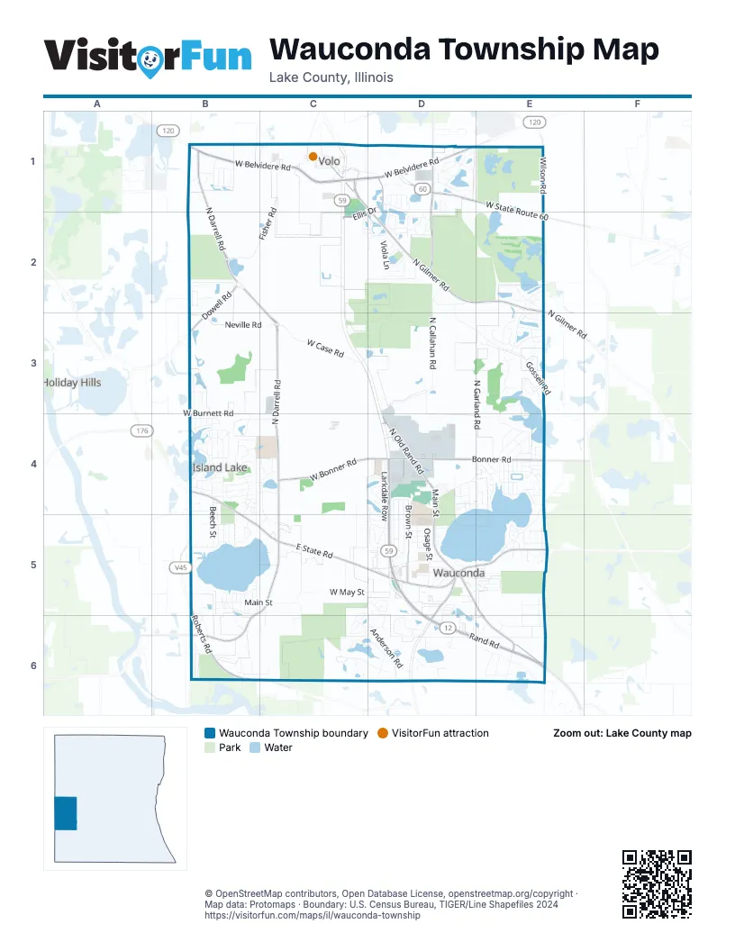
Street index of Wauconda Township
Each street on the sheet and the grid squares it crosses.
- West Belvidere RoadB1, C1, D1
- North Rand RoadD4, D5, D6, E6
- West State Route 60D1, E1, E2
- South Rand RoadD5, D6
- Ellis DriveD1, C2
- Barrington RoadD5, D6
- US 12 / IL 59C2
- East State RoadB4, B5, C5
- West Roberts RoadB5, B6
- West Liberty StreetC5, D5
- East Liberty StreetD5, E5
- Roberts RoadB4, B5
- North Darrell RoadB1, B2, C2, C3, C4, B5, C5, B6
- North Gilmer RoadC1, D2, E2
- Bonner RoadD4, E4
- North Fish Lake RoadD1, D2
- West Bonner RoadC4, D4
- North Main StreetD4, D5
- Brown StreetD4, D5
- South Main StreetD5, E5, E6
- Gilmer RoadC1, D1, D2
- North Old Rand RoadD4
- Wilson RoadE1, E2
- Old Rand RoadD4, E6
- Dowell RoadB2, B3
- Rawson Bridge RoadB6
- Dowell Road WestB3
- North Garland RoadE3, D4, E4
- North Callahan RoadD2, D3, D4
- Gossell RoadD2, D3, E3
- Fisher RoadC1, B2, C2
- Anderson RoadC5, D5, D6
- Larkdale RowD4, D5
- West Maple AvenueB5, C5, D5, B6, C6
- West Case RoadC3
- West Main StreetB5, C5
- Volo Village RoadC1, D1
- Eastway DriveB4
- West Burnett RoadB3, B4, C4
- Farmhill CircleD4, D5
- Neville RoadB3, C3
- Niagara DriveD1, D2
- Trailside LaneE3
- Liberty Lakes BoulevardE2, E3
- North Lakeview CircleC4, C5
- West Ivanhoe RoadD6, E6
- Savanna DriveD2, E2, E3
- Richard Brown BoulevardD1, D2
- Old Country WayD4, D5
- Greenleaf AvenueB4
- North Forest Garden RoadC4, C5
- Oak Grove CircleD6
- Osage StreetD5
- Grand BoulevardE4, E5
- Bedford LaneD1
- West Lakeview Drive SouthC6, D6
- Indian Ridge TrailD4, D5
- West Lakeview Drive NorthC6, D6
- Sheridan DriveE4
- West May StreetC5, D5
- Slocum Lake RoadD5
- Carriage Hill RoadB4
- Tamarack DriveE6
- Pineview BoulevardB1
- Beech StreetB4, B5
- Fishhook WayE3
- Meadowview DriveD5
- Bellows WayD1, E1
- Ivanhoe RoadE6
- Minuet CircleD2
- Galena DriveD1, E1
- Parkview DriveD4, B5
- North Williams Park RoadC5
- North Shore DriveE4
- Singing Hills DriveD2
- Viola LaneD2
- Burr Oak LaneB4
- Willow RoadD4, D5
- Westridge DriveB4, B5
- Kimball AvenueD5, E5
- Kingston DriveB3
- North Washington AvenueE4
- Water Stone CircleE4
- West Laurel AvenueD6
- Baroque AvenueD2
- Glacier WayE2
- Minerva AvenueD5
- Fairfield DriveB4
- North Virginia LaneE3
- North Jackson AvenueE4
- North Genesee StreetB5
- Madison AvenueE4
- Lakepoint DriveE6
- West Old Gilmer RoadD2
- North Hickory LaneE3
- Monroe AvenueE4
- North Cherrywood LaneE6
- Hollow Hill DriveD4
- Lake Shore BoulevardE4, E5
- Main StreetC5, C6
- Noble DriveB5, B6
- Northshore DriveE4
- North Wade AvenueE3, E4
- North Monroe AvenueE4
- North Lake DriveD4, E4
- Foxridge DriveB2
- Fern DriveB4
- Lake Shore DriveE6
- West Gardner RoadE4
- North Mack DriveC5
- Saddlewood DriveC5, D5, C6
- North Lakeland DriveD6
- George AvenueD5
- Harmony RoadC2, D2
- Lamphere RoadB5
- Harvest CourtB4
- Channel DriveB4
- Bluewater DriveE3
- Greenview DriveE5, E6
- Oakford Farms LaneB4
- Pennway CircleD6
- Bangs StreetD5
- Apple Valley DriveE3
- Wood Creek DriveB4
- Portage AvenueE3
- Great Falls DriveD1
- West Lakeview AvenueD5, E5
- Oak DriveE5, E6
- Forest DriveB4
- Brierhill DriveB4
- Clover RoadB4, D4, D5
- Midway DriveB4
- Adagio DriveD2
- Crestview DriveE5
- North Geraldine LaneB6
- North Madison AvenueE4
- Longacre LaneB4
- Sullivan Lake BoulevardB1, C1
- Fish Lake Beach RoadC1
- River Oaks LaneB4
- Lewis AvenueD5
- West Brown RoadE6
- West Church StreetD5
- West Mill StreetD5
- Cook StreetD4
- Lakeshore DriveE4
- North Hill AvenueE6
- Ridge RoadB4, C4
- Karl CourtD4
- Adams AvenueE4
- West Park AvenueB5
- Briar RoadB4, D4
- Woodland AvenueE5
- Redwood BoulevardC2, D2
- Beethoven StreetD1
- North Huston AvenueB5, B6
- Pershing DriveE4
- Stonybrook StreetE3
- Daniel StreetD5
- North Morey StreetB5
- Applewood DriveE3
- Oaks AvenueD5
- Highland AvenueE5
- Ridge AvenueE4
- Hill StreetE5
- Southern TerraceB4
- Dunbar RoadD5
- North Ada StreetB5
- North Harrison AvenueE4
- Purcell RoadD2
- West Wilson AvenueE5
- North Winding LaneD4
- Northern TerraceB4
- Center StreetB6
- Honeysuckle DriveB4
- South Shore DriveB4
- Woodland RoadE4
- Meadow Lane RoadB4, C4
- Pheasant TrailD6
- Hickory LaneE4
- HickoryB5
- Oakwood RoadD5
- Waters Edge DriveB5
- North McNally LaneC1
- North Meadow LaneE6
- Lipizzan LaneC6
- West Blakely ParkwayE6
- Henri DriveD4
- Laurel AvenueD4
- North Converse RoadB4, B5
- Commerce DriveD1
- North Brooks StreetC5, C6
- Brahms RoadD2
- Appaloosa TrailC6
- Wethington DriveE5
- Chopin PlaceD2
- Moraine Valley RoadE2
- Bernice StreetB5
- Schlesser DriveB1
- Jamie LaneD4
- Cannon RoadD1
- Foster RoadE5
- Helena AvenueD5
- Mayfair DriveB2
- Sunnyside AvenueE5
- Serenity LaneD3, E3
- Stanchuk LaneB6
- Seneca StreetD1, D2
- Synergy DriveD4
- West Slocum Lake RoadD5
- Borre DriveB1
- Clearwater DriveB1
- Mozart LaneD2
- Hermosa AvenueE6
- Walnut DriveB5
- Wilton RoadE6
- North Wells DriveD4
- Hillside AvenueE5
- North Fox Lake RoadC1
- High StreetD5, E5
- Highview RoadC4
- Garrison CircleB6
- Braeburn DriveE3
- North Ellen StreetB5
- Wauconda StreetE5
- Jennifer LaneB1
- Industrial DriveD4
- Napa Suwe LaneE3
- Wood Rose DriveC2
- Marine DriveC4, D4
- Mylith Park RoadB5
- North Swift CourtD6
- North Marion StreetC5, C6
- Elmcrest DriveD4
- Lake AvenueE5
- North Elm StreetB5
- Thomas CourtD5
- South Church StreetD5
- Marlene CourtD5
- Regency CourtD4
- Piccolo LaneC2, D2
- Washington AvenueE4
- Pondview DriveB1
- Farnsworth CircleB6
- Walnut RoadD5
- Parkland DriveB2
- East Mill StreetD5
- Barbara LaneE4
- North Poplar StreetB5
- Cattail CourtE2
- Hillside DriveB1
- Wisteria WayB6
- Pine StreetD5
- North Orchard RoadB6
- Sundown CourtE5
- Walnut Glen BoulevardB2
- Clearbook CourtE3
- Clearbrook CourtE3
- Sweet Clover WayE2
- Oak StreetB5
- Orton AvenueD5
- Shooting Star DriveB5
- North AvenueD5
- Grant PlaceE4
- Peace BoulevardD5
- Shooting Star CourtB5
- Harp AvenueD1
- Russel DriveC2
- West Pleasant View AvenueD4
- De Boer BoulevardD5
- North Willow RoadB6
- Park DriveB4
- Woodland Circle NorthB4
- Honey Hill DriveD5
- Kent AvenueD5
- West Lake ParkwayE4
- East Sanctuary DriveB4
- Kettle CourtB4
- Poplar DriveB3, B4
- Woodland DriveB4
- Edgewater ParkwayE4
- Hammond AvenueE5
- Mallard PointB3
- West Laurel CourtD6
- Kyle CourtD4
- Timpani PlaceD1
- Stillwater CourtE5
- Park PlaceE4
- Clearview AvenueE5
- Milbourn DriveD5
- Wegner RoadB1
- Patten DriveD6
- Bulldog AvenueD4
- Crescent TerraceD4
- North Oak Knoll RoadC4
- Fieldbrook AvenueE2
- Oakwood AvenueB4
- South Maple AvenueD5
- North Reardon DriveD4
- Oak Grove DriveD6
Things to do on the Wauconda Township map
Places on the map
- 3 Amigas
- Advance Auto Parts
- Advocate Medical Group
- Advocate Outpatient Center
- All Temp
- American Legion Post 911
- Bangs Lake
- Black Crown Marsh State Natural Area
- Bobby's Barrel Inn
- BP Shop
- Bubbles & Suds
- Buona
- Burger King
- Camping World
- Chase
- Chicago Equine Medical Center
- Converse Park
- Homer T. Cook Memorial Park
- Island Lake
- Island Lake City Hall
- Island Lake Post Office
- Kettle Grove Forest Preserve
- Liberty Square
- Matthews Middle School
- Monahan Lake
- North Tower Lake
- Oak Knoll Farm Airport
- Perricone Nursery
- Robert Crown Elementary School
- Sargent Marsh
- Singing Hills Forest Preseve
- Slocum Lake
- Stonewall Orchard Golf Club
- Symphony Meadows South Park
- The UPS Store
- Wauconda Grade School
- Wauconda High School
- Wauconda Post Office
- Woodman's Markets
Next to Wauconda Township
- Holiday Hills
© OpenStreetMap contributors, Open Database License, openstreetmap.org/copyright · Map data: Protomaps · Boundary: U.S. Census Bureau, TIGER/Line Shapefiles 2024















