

Indiana map
Center Township map
About 25,202 people live here (Census Bureau, 2024 estimate). The sheet's index lists 300 streets; Indiana Toll Road, West 450 North and West Johnson Road cross the most grid squares. Also on it: Briar Leaf Golf Club, Clear Lake and Crane Lake.
Open the map (PDF, US Letter)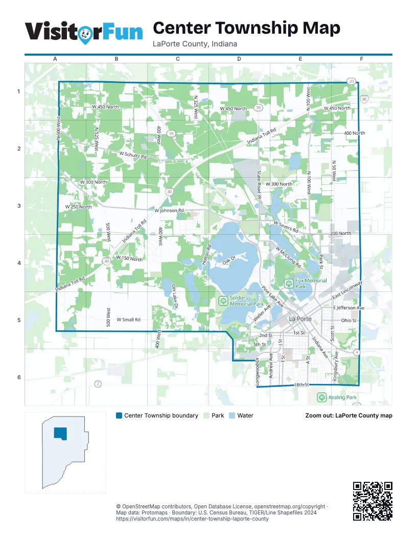
Street index of Center Township
Each street on the sheet and the grid squares it crosses.
- Indiana Toll RoadE1, F1, C2, D2, E2, B3, C3, A4, B4
- Indiana AvenueE5, E6, F6
- Pine Lake AvenueD3, D4, D5, E5
- State Road 39D2, D3, D4
- East LincolnwayF4, E5, F5
- LincolnwayE5
- J StreetE5, E6
- Kingsbury AvenueF5, F6
- West State Road 2D6, E6
- West Johnson RoadA2, A3, B3, C3, D3
- Monroe StreetE5, F6
- Longwood DriveD6
- North 100 WestE1, E2, E3, E4
- West Schultz RoadA2, B2, C2
- 2nd StreetD5, E5
- West Severs RoadD3, E3
- 1st StreetD5, E5
- West McClung RoadD4, E4
- West 400 NorthA2, C2, F2
- I StreetE5, E6
- A StreetE5, E6
- West 200 NorthE3, F3
- Truesdell AvenueE4, E5
- East Jefferson AvenueE5, F5
- Weller AvenueD5, E5
- Park StreetE4, E5
- Scott StreetF5
- Andrew AvenueE5, E6
- Jefferson AvenueE5
- West 18th StreetE6
- Ohio StreetE5, F5
- West 10th StreetE6
- Lake StreetD5, E5
- Rose StreetE5
- Madison StreetE5
- Central AvenueD5
- North Madison StreetE5
- Tyler StreetE5
- Newporte BoulevardE5
- North Park RoadE3, E4
- Zigler RoadD5, D6
- East 18th StreetE6, F6
- East 200 NorthF3
- Perry StreetE5
- Tipton StreetE5
- McClung RoadE4
- Osborn StreetE5
- West 450 NorthA1, B1, C1, D1, E1, F1
- North 400 WestC1, C2, C3, C4
- West Small RoadA5, B5, C5, D5
- West 300 NorthA3, B3, C3, D3, E3
- North 50 WestF1, F2, F3
- North 500 WestB3, B4, B5
- North 525 WestB1, B2, B3
- West 150 NorthA4, B4, C4
- Michigan AvenueE5, E6, F6
- Waverly RoadC4, D4, D5
- 5th StreetD5, E5
- West 250 NorthA3, B3, F3
- Holton RoadD3, C4, D4
- Clear Lake BoulevardE4, E5
- Lake Shore DriveD5
- North 325 WestC1, C2
- Orr Lake DriveC4, C5
- North Range RoadF1, F2
- F StreetE5, E6
- North Goldring RoadA4, A5
- Fox StreetE5, E6, F6
- K StreetE5, E6
- C StreetE5, E6
- Rumely StreetF5
- Roberts StreetF5
- West Waverly RoadC4
- Garden StreetD4, D5
- State StreetE5
- L StreetE5, E6
- Country Club DriveC3, C4, D4
- Plain StreetE5, F5
- West 350 NorthA2, E2, F2
- Division StreetE5, F5
- Washington StreetE5
- 3rd StreetE5
- 4th StreetE5
- Webber StreetE5, E6
- North 600 WestA2
- Virginia AvenueE5, F5
- Maple AvenueE5
- Rockwood StreetD4, E4, E5
- Woodward StreetE5
- Farrand AvenueE6
- D StreetE5, E6
- Island DriveD4
- Oak DriveD4
- Philadelphia StreetF4, F5
- Harrison StreetE5
- Ridge StreetE5
- Clay StreetE5
- 6th StreetE5
- Lakeside StreetD4
- Greenway StreetE6
- Niles StreetE5, F5
- Detroit StreetE5
- GreenacresE6, F6
- West Concord DriveB2
- E StreetE5, E6
- Jackson StreetE5
- Malaga Drive EastB2
- Grangemouth DriveD4, D5
- Genesis DriveF3, F4
- West 13th StreetE6
- Hillcrest StreetE6
- Tecumseh StreetE5, F5
- Clement StreetE5, F5
- Niesen StreetE4
- Linwood AvenueE5
- Allen StreetE5, F5
- Pennsylvania AvenueD5
- Lawrence StreetF5
- Palmer AvenueD3
- West 12th StreetE6
- Brighton StreetF4, E5
- Meadow Lark LaneC3
- John StreetE5
- West 11th StreetE6
- Grove StreetE5, F5
- Regency ParkwayE6
- Pulaski StreetE4, E5
- Boston StreetF4, F5
- Circle View LaneB4, C4
- West Skyline DriveA3
- East Maple AvenueE5, F5
- West Valley BoulevardD2
- Oberreich StreetF4
- H StreetE5, E6
- Talley StreetF5
- Sunrise BoulevardC3, C4
- North Pine Ridge DriveB4
- Eastshore ParkwayD4, E4
- West 14th StreetE6
- Malaga Drive WestB2
- Nilewood DriveC4, D4
- Veterans Memorial ParkwayD4, D5
- Closser AvenueD3, D4
- Marquette StreetD4, E4, E5
- Hoelocker DriveE4, E5
- Colfax AvenueD5, D6
- Woodson StreetE5, F5
- Factory StreetF4
- B StreetE5, E6
- Planett StreetF4
- Bond StreetF5
- Judson RoadD3
- Eggebrecht RoadD5, E5, D6
- North Jongkind Park RoadA3
- Koomler DriveE4, F4
- Crestview DriveB4, C4
- Stone Lake DriveD5
- Summit DriveC4
- Orr LakeC4
- Erie StreetE4, F4
- North Tiffany Woods DriveD2, E2
- Bach StreetE4, F4
- Canterbury DriveC3
- West Pawnee DriveC5
- Kingsporte AvenueE6
- West Timber Ridge RoadC5
- Dogwood DriveD4
- Orchard AvenueD5
- Bordeaux DriveC3
- 8th StreetE6
- Crest View LaneB4, C4
- G StreetE5
- Wright AvenueE6
- Sara LaneC3, C4
- West Sangria DriveB2
- South AvenueF5, E6
- Southmoor RoadE6, F6
- Williams StreetD4, E4
- North Jongkind Park DriveA3
- Federal AvenueE6
- Cable StreetE4, F4
- Hidden Oaks TrailC5, D5
- Beechwood DriveF6
- Small CourtC5
- Cherry StreetE4, F4
- Warsaw StreetE4, F4
- Vintage Hills TrailA1
- West Van Gogh TrA3
- Chicago StreetE5
- Roosevelt StreetE4
- Adams StreetE5
- East 10th StreetE6
- North Horseshoe BendE3
- Victoria CircleD6
- North StreetF5
- West Horseshoe BendE3
- Bluffside RoadD3
- North Maplewood DriveA1
- Rustic DriveB4
- Erin DriveC2
- North Andrea DriveC2
- Warwick StreetE5
- North Vineyard DriveB2
- North Kuchar DriveD3
- Timberlake DriveE1
- Darlington StreetF4
- McCollum StreetE5, F5
- Hawthorne StreetD5, E5
- Orchard BluffD4
- Forest DriveF6
- Fremont StreetE4
- West Greenbrier LaneC3
- West Tokay DriveB2
- Alexander StreetE5
- Farmwood DriveC4
- Maple DriveD4
- Melrose StreetD5, E5
- East 16th StreetE6
- West 370 NorthA2
- East 12th StreetE6
- Henry StreetF5
- Morrison StreetF5
- 7th StreetE6
- Polk StreetD4, E4
- South 400 WestC5
- Miller StreetE6
- Spring Haven DriveC4
- North Woodland DriveC5
- West Shorewood DriveC1
- Warren StreetD4, E4
- Fairfield AvenueD5
- Plummer StreetE5
- West 16th StreetE6
- Noble StreetE5
- Valleywood DriveE3
- Pine StreetE4
- Farmwood LaneC4
- Kingsporte LaneE6
- Sallwasser DriveD5
- North Cha Mar Hills DriveE2, E3
- Grayson RoadD4
- West Swanson DriveE3
- Cook StreetF4
- Oakwood StreetD5
- Riesling TrailB2
- Heinz StreetE4, E5, F5
- North Carmelo LaneA3
- West 15th StreetE6
- West High-Point DriveD2
- North Summit Valley DriveA3
- North Paden DriveC2
- Clark DriveC3
- Greenleaf StreetD5
- Laurel StreetE4
- Berkel DriveF4
- Stonehedge WayD2, D3
- Walton AvenueE6
- Country Acre TrailC3
- Maple Garden DriveE6
- Anthony DriveC2
- West Lakeview DriveA3
- West Pleasant Hills TrailA3
- Stanton StreetE4
- Carriage CourtD6, E6
- Evergreen DriveF5, F6
- Ardmore AvenueD3
- Whirlpool DriveF4
- Edgewood LaneF5, F6
- Franklin CourtE5
- Woodlawn DriveF6
- Home StreetD4
- North Chianti DriveB2
- North Wilhelm RoadE1
- Van Gogh DriveA3
- Walker StreetE5
- Crescent DriveF6
- Belden StreetE4, F4
- Ridgeway StreetF5
- Wabash StreetD5
- West Windsor CourtC3
- Edgewood CourtF5
- Kowal DriveC3
- Chablis DriveB2
- Muir CourtC4
- West Kama DriveE2
- West Tiffany Woods DriveE2
- Haviland StreetD4
- Chateau DriveC3
- Illinois AvenueD5
- Teegarden StreetE5
- North Fox Hollow DriveA2
- Burgundy TrailB2
- West Regal DriveB3
- Frank StreetF5
- Furnace StreetE5
- Holcomb StreetE5, F5
- North Orr Lake RoadC4
- North Rhine TrailB2
- Elm DriveD4
- Stanley CourtF5
Places on the map
- Briar Leaf Golf Club
- Calvin Huff Wildlife Preserve
- Charles W. Lindewald Park
- Circa 1856
- Clear Lake
- Crane Lake
- Critchfield Elementary
- Fays Marina & Outdoor
- Fays Marina Boat Storage
- Fishtrap Lake
- Fox Memorial Park
- Hailmann Elementary School
- Handley Elementary School
- Hennessy Wetland
- Horseshoe Lake
- Huber's Marine Boat Storage
- Huber's Service Center
- Kiwanis Field
- Kiwanis-Teledyne Park
- La Porte
- La Porte High School
- LaPorte County Courthouse
- LaPorte Juvenile Correctional Facility
- Legacy Hills Golf Club
- Lily Lake
- Lower Lake
- LP - The Noodle
- NewPorte Landing
- Northwest Health La Porte
- Orr Lake
- Pine Lake
- Pine Lake Cemetery
- Pine Lake Community Center
- Rumely Pond
- Sherwood Forest
- Soldiers Memorial Park
- Stone Lake
- Timber Ridge
- Woodland Trail Loop #1
- Woodland Trail MTB Orange Loop
© OpenStreetMap contributors, Open Database License, openstreetmap.org/copyright · Map data: Protomaps · Boundary: U.S. Census Bureau, TIGER/Line Shapefiles 2024















