

Indiana map
Chesterton map
About 14,655 people live here (Census Bureau, 2024 estimate). The sheet's index lists 300 streets; Indiana Toll Road, North State Road 149 and South 11th Street cross the most grid squares. Also on it: Sand Creek Country Club, The Brassie Golf Club and Billington Lake.
Open the map (PDF, US Letter)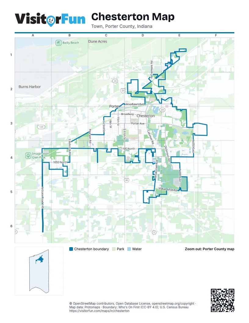
Street index of Chesterton
Each street on the sheet and the grid squares it crosses.
- Indiana Toll RoadA5, D5, E5
- North Calumet AvenueD4, D5
- Calumet RoadD4
- North State Road 149A4, A5, A6
- Max Mochal HighwayA4
- Dickinson RoadE3, E4
- West 1100 NorthC4, D4
- West Porter AvenueC3, D3
- South 11th StreetC3, D3, D4
- West 1050 NorthA4, B4
- BroadwayC3, D3
- South 5th StreetD3, D4
- North 250 EastE3, E4
- East Porter AvenueD3, E3
- South 23rd StreetC3, C4
- South Calumet RoadD3, D4
- South Babcock RoadB4
- North 100 EastD4
- East 1100 NorthD4, E4
- North Calumet RoadD2, D3
- North 200 EastE4, E5
- Indian Boundary RoadD2, E2
- Pearson RoadC3, C4
- Wabash AvenueC3, D3
- South 15th StreetC3
- Rail RoadD4, E4
- Woodlawn AvenueC2, D2, C3
- East 1050 NorthD4, E4
- North 50 EastD4
- East 1200 NorthE3
- Robbins RoadA6
- South 8th StreetD3
- Voyage BoulevardD4
- Waverly RoadC2, C3
- North Meridian RoadD4
- North 8th StreetD3
- North 15th StreetC3
- Mineral Springs RoadC4
- North Tremont RoadD2
- North 4th StreetD3
- North Jackson BoulevardC3
- County Road 100 EastD2
- Lenburg RoadA4
- Francis StreetC3
- East 950 NorthD5
- West Morgan AvenueC3, D3
- Sand Creek DriveE3, E4
- Snead AvenueE3, E4
- West Indiana AvenueC3, D3
- Gateway BoulevardD5, E5
- Village PointD4, E4, D5
- Park AvenueC3, D3
- Jefferson AvenueC3, D3
- Texas StreetC3, C4
- Chestnut BoulevardD4
- South 14th StreetC3
- South Jackson BoulevardC3
- South 19th StreetC3
- Pinehurst AvenueB4, B5
- South 2nd StreetD3
- South 18th StreetC3
- Washington AvenueC3, D3
- Westchester AvenueC3, D3
- Ryder RoadE4
- West Lincoln AvenueC3, D3
- Michael DriveE3
- Westwood Lane SouthB4
- Portage AvenueC3
- South 10th StreetD3
- South 6th StreetD3, D4
- Fox Point DriveD4
- Amen Corner CourtE4
- Hogan AvenueE3, E4
- South 4th StreetD3
- Sandpiper DriveE3
- South Park DriveD3
- Windridge DriveD4
- Laurel Creek DriveD4
- East Morgan AvenueD3
- Union AvenueC3, D3
- Kilarney RoadE4
- Chamborde LaneE4
- Grant AvenueD3
- Sand Creek Drive NorthE2, E3
- South 22nd StreetC3
- South 21st StreetC3
- Catkin CircleD4
- Spyglass CircleE3, E4
- North Veden RoadE1
- South 20th StreetC3
- Primrose CircleD3
- Legend CircleE4
- South 3rd StreetD3
- Littler DriveE4
- Westwood LaneB4
- Matson StreetD4, D5
- West Taylor StreetD2
- Morningside DriveD2
- West 1000 NorthA5, B5
- Dunewood DriveD3
- Ritter StreetB4
- South 13th StreetC3
- South 12th StreetC3
- South 9th StreetD3
- Roberts DriveE2, E3
- Oakwood DriveD3
- Coffee Creek DriveD2
- Dunbar StreetE4
- Shannon DriveD3
- Armour CourtE4
- South 16th StreetC3
- Gossett Mill AvenueE4
- Chalemel DriveD2
- Bramble TraceE4
- East Saemann RoadD2
- East Indiana AvenueD3
- Beverly DriveD4
- Kelle DriveE4
- Sawgrass DriveE3
- Easton Park DriveE3, F3
- Wilson StreetD3
- Carick LaneE4
- Landman StreetD3
- Lincoln AvenueC3, D3
- Harrington AvenueE4
- Jeffrey StreetD3
- Nelson DriveE4
- Tour TraceE4
- County Road 1050 NorthD4, E4
- Roosevelt StreetD3
- Frontage RoadD2
- Locust StreetD2, D3
- Dakota StreetC3
- Monterey DriveE3, E4
- Bowser AvenueD3
- Marquardt StreetD2
- North Old State Road 49D4, D5
- Abbey LaneD3
- Drivers WayB3, B4
- Delos Marr AvenueE4
- Watertower DriveE3
- Maximilian DriveC4
- Venturi DriveD3, D4
- Tanglewood LaneE3, F3
- Toms CourtE4
- Warren StreetD2
- Griffin Lake AvenueC3, C4
- Iowa StreetC3
- Idaho StreetC3
- Woodland DriveC4
- Parmaker DriveB4
- Colonial DriveE3
- Sotogrande CourtE4
- Church StreetA4
- Bogey BoulevardC4
- Gustafson AvenueE4
- Rawlins DriveE4
- Harrison RoadE1
- Hickory Grove StreetE4
- North 3rd StreetD3
- Fairway DriveB4
- Plaza DriveD2
- Sarazen CourtE4
- Brassie AvenueC3, C4
- Lost Tree DriveE3
- Tower StreetA4
- Crocker StreetA4
- Joliet AvenueA4
- Eagle Nest DriveE3
- Green Meadow LaneD4
- North 50 WestC4
- Long Bridge DriveD2
- South 25th StreetC3, C4
- Council DriveE2, E3
- Murray StreetE4
- Abercrombie DriveB4
- Technology DriveD4
- Taft StreetD3
- West Michigan AvenueD3
- Dogleg DriveC4
- South 24th StreetC3, C4
- Tamarack TrailD2
- South 17th StreetC3
- Duffer DriveB4
- Ironwood CourtE3
- Springdale StreetB4
- Mississinewa StreetD2
- Olivia CourtD3, D4
- Highland DriveE3
- Moraine RoadD2
- Hilfiger DriveB4
- Bostwick AvenueE4
- Brown CourtD3
- Terreno DriveC4
- Mission Hills CourtE3
- Birdie WayC4
- Oak Trail DriveD4
- Gladys LaneD3, D4
- North 16th StreetC3
- Joal DriveD4
- Aeropostale DriveB4
- White Willow LaneD4
- Burr Oak DriveD2
- South 7th StreetD3
- Carmody DriveE3
- Eagle StreetB4
- Oakdale AvenueA4, B4
- Chesterton BoulevardD3
- Wildwood CourtE3, F3
- Lois LaneD3
- Lombardy CourtD4
- Glendale StreetB4
- Pam DriveD2
- Read DriveE3
- Crabtree LaneD4
- Pioneer TrailD4
- Wood StreetC3
- Brown StreetD3
- Pepperbush AvenueB4
- Timberwood LaneE3
- 1050 NorthD4
- Olde Towne SquareE3
- Nelson CourtE4
- Sand Wedge CircleC4
- Dalke RoadA5
- Union CourtD3
- Flatz DriveC2, D2
- Penny LaneD2
- Larchwood AvenueB4
- Chase DriveE1
- Industrial BoulevardA4
- Pinneys CourtD2
- Dogwood LaneC3
- Kingsmill DriveE3
- Hagen DriveE4
- Richter StreetD3
- David DriveC3
- Krieger StreetC3
- Melanie LaneE3
- Old Farm LaneD4
- Sequoia CourtE3
- Jacob LaneC4
- Redwood LaneE3, F3
- Laura LaneC3
- Birch Trail DriveD4
- Burlwood DriveB4
- Industry DriveA4
- Riverside DriveD2
- Center StreetA4
- Partridge WayD4
- Cherry Hills DriveE3
- Louisa LaneD3
- Saratoga LaneC3
- Westchester CourtD3
- Cory LaneC4
- Creita StreetD3
- Cherrywood LaneE3
- Johnson StreetC3
- Tupelo LaneC3
- 25th PlaceC3
- Briarcliff CourtD4
- North Hadenfelt RoadE1
- Eugene StreetC3
- Candlewood CourtD4
- Foulis CourtE4
- Quicksilver DriveB4
- Annabelle CourtC3
- Eastwood LaneE3
- Elgin StreetA4
- Meadowdale AvenueB4
- Bunker DriveB4
- Butterfield DriveE3
- Wren CourtE3
- Spruce LaneE3
- West StreetD3
- Northwood LaneE3
- Lob Wedge LaneC4
- DunbarE4
- Ivy StreetD3
- Golden Eye CircleE4
- Pradera TrailC4
- Grady StreetD2
- Hawthorne LaneC3
- North 18th StreetC3
- Catigny CourtE4
- Timber CourtD3
- Brae Burn BoulevardE3
- East Paul Revere CourtE4
- Hunter's CourtD4
- Shamrock DriveD3
- Cypress LaneE3
- Emerald DriveD3
- Ahrens RoadE2
- Cole StreetE4
- Timberland DriveB4
- Manor DriveD4
- Summerlin DriveE3
- East Mekeland RoadE1
- Putter ParkwayC4
- Nautica DriveB4, B5
Places on the map
- 1st Source Bank
- AJ's Pizza
- Aldi
- All About Kids Dental Care
- Bailly Elementary School
- Bethlehem Lutheran Church
- Beverly Plaza
- Billington Lake
- Bob Evans
- Boys & Girls Club
- Burger King
- Centier Bank
- Cherries & Berries Pancake House
- Chesterton Cemetery
- Chesterton Fire Department
- Chesterton High School
- Chesterton Municipal Complex
- Chesterton Park
- Chesterton Post Office
- Chesterton Senior High School Baseball Field
- Chesterton Senior High School Softball Field
- Chesterton Town Hall
- Chestnut Lakes
- Chubb Lake
- City Electric Supply
- Coffee Creek Park
- Coffee Creek Watershed Preserve
- Culver's
- Danny O's Bar & Grill
- Dean's Tire & Auto
- Dogwood Park
- J. Timothy Ritchie Nature Preserve
- Keith Richard Walner Nature Preserve
- Morgan Lake
- New Life Wesleyan Church
- Saint Patrick School
- Sand Creek Country Club
- The Brassie Golf Club
Next to Chesterton
- Burns Harbor
- Dune Acres
- Porter
© OpenStreetMap contributors, Open Database License, openstreetmap.org/copyright · Map data: Protomaps · Boundary: Who's On First (CC-BY 4.0); U.S. Census Bureau















