

Indiana map
Coolspring Township map
About 15,523 people live here (Census Bureau, 2024 estimate). The sheet's index lists 291 streets; West 300 North, Wozniak Road and North Shebel Road cross the most grid squares. Also on it: Camp To-Pe-Ne-Bee, Patriot Park and Pinhook Bog.
Open the map (PDF, US Letter)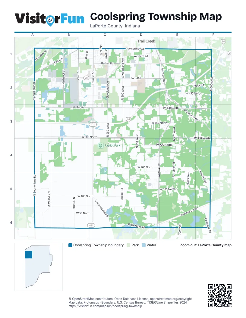
Street index of Coolspring Township
Each street on the sheet and the grid squares it crosses.
- 2nd PlaceA1
- Cedar Lake AvenueA1
- Chandler RoadA1
- Earl RoadA1, B1, A2
- Fox Lake AvenueA1
- Geneva Lake AvenueA1
- Mentor AvenueA1
- White Lake AvenueA1
- Beech StreetB1
- Bies StreetB1
- Bolka AvenueB1
- Brinkman AvenueB1, C1
- Broadbrook LaneB1
- Buffalo StreetB1
- Chestnut StreetB1, C1
- Dorchester RoadB1
- Duxbury CourtB1
- Essex LaneB1
- Georgetown RoadB1
- Hampden RoadB1
- Hawthorne DriveB1
- Hickory StreetB1
- Hitchcock StreetB1, B2, B3
- Hoyt StreetB1
- Kent RoadB1
- Lexington RoadB1
- Ogden AvenueB1
- Ohio StreetB1, B2, B3
- Ramion AvenueB1
- Redpath AvenueB1
- Riviera DriveB1
- Saint John RoadB1, C1, B2
- Southwood DriveB1, C1
- Swasick AvenueB1
- Walnut StreetB1, C1
- West Coolspring AvenueB1
- Willis WayB1
- Windsor RoadB1
- Adams StreetC1
- Alfred StreetC1
- Barker RoadC1
- Beaver DriveC1
- Belmont CourtC1
- Boyd CircleC1
- Boyd CourtC1
- Breckenridge AvenueC1
- Cleveland AvenueC1, C2, C3
- Concord DriveC1
- Eddy StreetC1
- Euclid AvenueC1
- Franklin StreetC1, C2, C3
- Garrettson AvenueC1
- Holly RoadC1
- Jackson StreetC1
- Jefferson StreetC1
- Joyce AvenueC1
- Kenwood PlaceC1
- Lawndale CourtC1
- Lawndale PlaceC1
- Mall CourtC1
- Maple StreetC1
- Oak StreetC1
- Orchard StreetC1
- Rosedale AvenueC1
- South Park StreetC1
- South Woodland AvenueC1, C2
- Wabash StreetC1
- Welnetz RoadC1, D1
- West Barker RoadC1
- Wintergreen AvenueC1
- Woods Edge DriveC1, D1
- Woodside DriveC1
- Black Oak DriveD1
- Coolspring CircleD1
- Dody AvenueD1
- Dogwood DriveD1
- East Coolspring AvenueD1
- Edgemoor DriveD1
- Greentree DriveD1
- Johnson RoadD1, E1, E2
- Larain DriveD1
- Laurel DriveD1
- Laurel RoadD1
- Longwood DriveD1
- Martin DriveD1
- Oakland AvenueD1
- Pinecone DriveD1
- Pinetree DriveD1
- Red Oak DriveD1
- Redwood DriveD1
- Roeske AvenueD1
- Sal CourtD1
- Salem CourtD1
- Salem StreetD1
- South Roeske AvenueD1
- Spruce DriveD1
- Sunnyside DriveD1
- Trail StreetD1
- White Oak DriveD1
- Yanke RoadD1
- Cricket CourtE1
- Cricket LaneE1
- Firefly DriveE1
- Menke RoadE1
- North Bleck RoadE1, E2
- Pepple ParkwayE1
- North 600 WestF1, F2, F3
- Alpine DriveA2, B2
- County Line RoadA2, A3
- Deerfield TrailA2, B2
- Foxpoint DriveA2
- Lakeview DriveA2, B2
- Lincoln DriveA2, B2
- Marsh Arbor TrailA2, B2
- Midway DriveA2
- Old Chicago RoadA2
- Boone DriveB2
- Cobblestone BoulevardB2
- Creek RidgeB2
- Crestwood DriveB2
- Eastland DriveB2
- Edgebrook DriveB2
- Elgin CourtB2
- Farmington DriveB2
- Glencove DriveB2
- Kings WayB2
- Mansard DriveB2
- Maple Grove DriveB2
- Mariners WayB2
- National BoulevardB2
- Old Oak DriveB2
- Pinetree CourtB2
- Pleasant RidgeB2
- Rivers Walk LaneB2
- South CourtB2, D2
- South Lake CourtB2, C2
- Southwind DriveB2, B3
- Terrace Acres ParkwayB2
- Valley Oak DriveB2
- Village RoadB2, C2
- Waters Edge PlaceB2
- Westwind DriveB2, C2
- Windy LaneB2, C2
- Alderson CourtC2
- Ameriplex DriveC2
- Kintzele RoadC2
- Larkspur LaneC2
- Lindsey LaneC2
- Meijer DriveC2
- Normandy DriveC2
- North 900 WestC2, C3
- Pahs RoadC2, D2, E2
- Clover LaneD2
- Division LaneD2
- Meadow BoulevardD2
- Prairie LaneD2
- Ben Davis DriveE2
- Brookside CourtE2
- Budlee DriveE2
- Cindy LaneE2, E3
- Kent DriveE2, E3
- Lincoln RoadE2, F2
- Linda LaneE2
- Lombard RoadE2
- Michael PlaceE2, F2, F3
- North 660 WestE2
- North 675 WestE2, E3, E4, E5
- North 700 WestE2, E3, E5, E6
- North Brookside DriveE2
- North Glenbrook RoadE2
- North Rukmin TrailE2
- North Winesap RoadE2
- Pippin DriveE2
- Red Apple DriveE2
- Vintage CourtE2
- West 450 NorthE2, F2
- West Bleck RoadE2, F2
- West Calloway StreetE2, E3, F3
- West Glenbrook DriveE2
- West Johnson RoadE2, E3, F3
- West Magnolia AvenueE2
- West Pinecrest DriveE2
- West Rukmin TrailE2
- Wozniak RoadE2, E3, D4, E4, D5, D6
- Armand AvenueF2
- Bleck RoadF2
- Hemlock DriveF2
- Laura TrailF2
- Mushroom LaneF2, F3
- North 630 WestF2, F3
- North Lee Len TrailF2
- Sunset LaneF2, F3
- West 500 NorthF2
- West Laura LaneF2
- West Lee Len TrailF2
- West 300 NorthA3, B3, C3, D3, E3, F3, F4
- West Kieffer RoadA3, B3, C3
- Franciscan WayB3, C3
- North 1100 WestB3
- East Kieffer RoadC3
- Frontage RoadC3
- North 950 WestC3, C4
- North Frontage RoadC3
- West 400 NorthC3, D3, E3, F3
- Gruenke RoadD3
- North 825 WestD3, D4
- North 850 WestD3, D4, D6
- North 875 WestD3
- West 350 NorthD3, E3, F3
- West 375 NorthD3
- West Happy Landing LaneD3, E3
- Cherie LaneE3
- Dorothy LaneE3
- Dorthy LaneE3
- Evergreen TrailE3
- Mason DriveE3
- North 725 WestE3, E4
- North Cross TrailE3
- North Dana DriveE3, F3
- North Everly DriveE3
- North Goldring RoadE3, E4, F4, F5
- North Promenade CircleE3
- North Tiffany DriveE3, E4
- Skylark DriveE3
- West Cross TrailE3
- Malaga DriveF3
- North 625 WestF3
- North Skyline DriveF3
- Shiva West DriveF3
- West 370 NorthF3
- West Pine Cone DriveF3
- North County Line RoadA4, A5, A6
- West 250 NorthA4, B4, F4
- North Rolling Meadows DriveC4
- West 200 NorthC4, D4, E4
- West Morraine Hills RoadC4
- West Summitt CourtC4
- West Valley CourtC4
- Claire CourtD4
- Country LaneD4, D5
- Cynthia CourtD4
- Cynthia DriveD4, E4
- Dianne CourtD4
- Dianne DriveD4
- North Dianne DriveD4
- North Shebel RoadD4, C5, D5, C6, D6
- Orchard CourtD4
- Orchard DriveD4, E4
- West 275 NorthD4, E4
- West Dianne CourtD4
- Cidermill RoadE4, E5
- North Forrester RoadE4, E5, F6
- Pinebrook DriveE4
- West Oakmeadow DriveE4
- North Shawnee TrailF4
- East 1325 NorthA5
- Farmview RoadA5, B5
- North 1150 WestA5, A6
- West 100 NorthA5, B5, C5
- West 125 NorthA5, D5, E5, F5
- North Otis RoadB5, B6
- North Holmesville RoadC5, C6
- North Cortland LaneD5
- North Country LaneD5
- North Jonathan CourtD5
- Ridgeview RoadD5
- Surrey LaneD5
- West Applewood DriveD5
- West Arndt CourtD5, E5
- West Cathy Lynn DriveD5
- West Country LaneD5
- Aspen DriveE5
- Forestor Hills DriveE5
- Honeysuckle LaneE5
- Marty DriveE5
- Peach Tree LaneE5
- West Cidermill RoadE5
- West Forrester RoadE5, F6
- Indiana Toll RoadF5, D6, E6, F6
- North 640 WestF5, F6
- West 150 NorthF5
- West Goldring RoadF5
- East 1275 NorthA6
- North Williams RoadA6
- West 50 NorthA6, B6, C6
- West Division RoadB6, C6, D6
- West Shebel RoadC6, D6
- West 20 NorthD6
- South 700 WestE6
- South Forrester RoadF6
- West Small RoadF6
Places on the map
- 1st Source Bank
- 400 North Medical Center
- Aaron's
- Adams Park
- Advance Auto Parts
- Al's Supermarket
- Albano's Villa
- Aldi
- Alick's Home Medical Equipment
- AMC Showplace Michigan City 14
- Army National Guard Center
- Barker Middle School
- Barker Woods Nature Preserve
- Camp To-Pe-Ne-Bee
- Coolspring Elementary School
- Creek Ridge County Park
- Dingler Lake
- Dunes Plaza
- Edgewood Elementary School
- Formoer Marquette Mall
- Franciscan Health Michigan City
- Henry Lake Area
- Lake Topenebee
- Love's Travel Stop
- Marquette Mall
- Meijer
- Menards
- Michigan City Campground
- Michigan City High School
- Patriot Park
- Pinhook Bog
- Ruby Woods
- Spychalskis Pond
- Stribel Park
- Swan Lake Memorial Gardens
- Swede Lake
- Victory Honda Michigan City
- Walmart Supercenter
- Walton Lake
- Waterford Storage
Next to Coolspring Township
- Trail Creek
© OpenStreetMap contributors, Open Database License, openstreetmap.org/copyright · Map data: Protomaps · Boundary: U.S. Census Bureau, TIGER/Line Shapefiles 2024















