

Indiana map
La Porte map
About 22,444 people live here (Census Bureau, 2024 estimate). The sheet's index lists 300 streets; Boyd Boulevard, Indiana Avenue and East Lincolnway cross the most grid squares. Also on it: La Porte Municipal Airport, Beechwood Golf Course and Clear Lake.
Open the map (PDF, US Letter)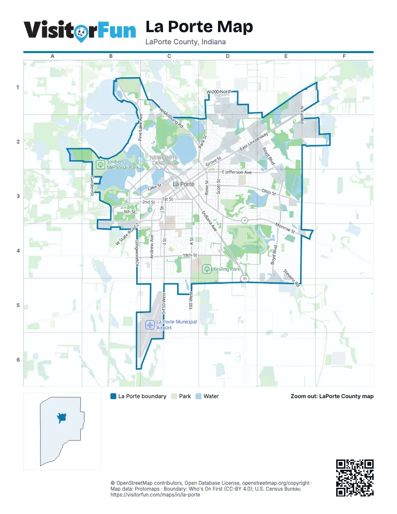
Street index of La Porte
Each street on the sheet and the grid squares it crosses.
- Indiana AvenueC3, D3, D4, D5
- East LincolnwayE1, D2, E2, D3
- Pine Lake AvenueB1, B2, C2, C3
- Kingsbury AvenueD3, D4
- LincolnwayC3, D3
- J StreetC3, C4
- West State Road 2B3, C3, B4
- State Road 39B1
- Monroe StreetC3, D3, E3, E4
- Longwood DriveB4
- Boyd BoulevardD2, E2, E3, E4, E5
- Ohio StreetD3, E3
- I StreetC3, C4
- A StreetC3, C4, C5
- 2nd StreetB3, C3
- 1st StreetB3, C3
- Andrew AvenueC3, C4, C5
- East Jefferson AvenueE2, D3, E3
- West 18th StreetB4, C4
- North Fail RoadE1, E2
- West McClung RoadB1, C1, C2
- Truesdell AvenueC2
- Weller AvenueC2, B3, C3
- Park StreetD1, D2
- Scott StreetD2, D3
- Jefferson AvenueC3, D3
- West 10th StreetC4
- Lake StreetC3
- East 18th StreetC4, D4
- Rose StreetD3
- South 150 WestC5
- Madison StreetC3
- South 100 WestC5
- East Division RoadE3
- Crescent DriveD4
- Zigler RoadB3, B4
- Central AvenueB3, C3
- North Madison StreetC2, C3
- Tyler StreetC3
- Newporte BoulevardC2, C3
- North Park RoadD1
- West 200 NorthD1
- East Boyd BoulevardD5, E5
- Perry StreetC3
- East 150 NorthE2, F2
- Tipton StreetD2, D3
- McClung RoadC2, D2
- Osborn StreetC3, D3
- Division RoadE3
- North 100 WestD1
- Michigan AvenueC3, D3, D4
- 5th StreetB3, C3
- K StreetC3, C4
- Clear Lake BoulevardC2
- Lake Shore DriveB2, B3
- Waverly RoadB2, C2
- F StreetC3, C4
- Fox StreetC3, D3, D4
- C StreetC3, C4
- Rumely StreetD2, D3
- Roberts StreetD2, D3
- L StreetC3, C4
- State StreetD2, C3
- Plain StreetD3
- Fieldstone DriveC4, C5
- Division StreetD3
- Washington StreetC2, D2, C3
- Virginia AvenueD3
- 3rd StreetC3
- 4th StreetC3
- Webber StreetD3, C4, D4
- Darlington StreetD2, E2
- Maple AvenueC3, D3
- Rockwood StreetC2
- West 250 SouthB6, C6
- Woodward StreetD3
- Farrand AvenueD3, D4
- D StreetC3, C4
- Philadelphia StreetD2, D3
- Garden StreetB2, B3
- Harrison StreetC3, D3
- Ridge StreetD3
- Clay StreetC3, D3
- Whitehead RoadE2
- Sagamore ParkwayD3, E3
- 6th StreetC3
- Lakeside StreetB1, B2
- Whispering BoulevardE3, E4
- Stevens RoadE4, E5
- Greenway StreetC4
- Niles StreetD3
- Detroit StreetC2, C3, D3
- GreenacresD4
- Oakdale AvenueE3
- E StreetC3, C4
- Jackson StreetC3, D3
- Grangemouth DriveB2
- Genesis DriveD1, D2
- West 13th StreetC4
- Hillcrest StreetD4
- Tecumseh StreetD3
- Clement StreetD3
- Willow Bend DriveC4, C5
- Niesen StreetD2
- Linwood AvenueC2, C3, D3
- Allen StreetD2
- Pennsylvania AvenueB3, C3
- Briarwood CircleB4, C4
- Lawrence StreetD2, D3
- West 12th StreetC4
- Brighton StreetD2
- John StreetD3
- West 11th StreetC4
- Grove StreetD2
- Silverbrook AvenueE3
- Regency ParkwayC4
- Pulaski StreetD2
- Boston StreetD2
- East Maple AvenueD3
- Keston Elm DriveD4
- Oberreich StreetD2
- H StreetC3, C4
- Talley StreetD2
- Eastshore ParkwayB1, C1
- West 14th StreetC4
- Orchard AvenueB3
- Veterans Memorial ParkwayB2, C2
- Marquette StreetC2
- Hoelocker DriveC2
- Colfax AvenueB3
- Woodson StreetD3
- Factory StreetD2
- B StreetC3
- Planett StreetD2
- Bond StreetD2, D3
- Eggebrecht RoadB3, C3
- Koomler DriveD2
- Stone Lake DriveB3
- Erie StreetD2
- Bach StreetD2
- Beechwood DriveD3, D4
- Kingsporte AvenueC4
- Poplar LaneE1
- Industrial ParkwayE2, F2
- 8th StreetC3
- G StreetC3
- Wright AvenueD4
- Greenwood AvenueE3, E4
- South AvenueD3
- Southmoor RoadD4
- Williams StreetB2, C2
- Federal AvenueC4
- Cable StreetD2
- Cherry StreetD2
- Warsaw StreetD2
- Linden DriveE3, E4
- Chicago StreetC3
- Roosevelt StreetD2
- Adams StreetC2, D2, D3
- East 10th StreetC4, D4
- Victoria CircleB4, C4
- North StreetD2
- Albin DriveE3
- Warwick StreetC3, D3
- McCollum StreetD3
- Hawthorne StreetC3
- Grandview AvenueE3, E4
- Closser AvenueB2
- Forest DriveD4
- Fremont StreetC2
- South 250 EastE4
- Alexander StreetC3, D3
- Melrose StreetC3
- East 16th StreetC4, D4
- East 12th StreetC4, D4
- Henry StreetD3
- Morrison StreetD3
- Feikes BoulevardE3
- 7th StreetC3
- Polk StreetB2, C2
- Deerfield CrescentE4
- Miller StreetC4
- Warren StreetC2
- Fairfield AvenueC3
- Plummer StreetC3, D3
- West 16th StreetC4
- West 23rd StreetC4
- Noble StreetC3, D3
- Pine StreetD2
- West 22nd StreetC4
- West 20th StreetC4
- West 21st StreetC4
- West 19th StreetC4
- Burson AvenueD2
- Kingsporte LaneC4
- Sallwasser DriveB3, C3
- Timber LaneE1
- Cook StreetD2
- Lawndale AvenueE3
- Oakwood StreetB2, C2, C3
- Heinz StreetD2
- Legacy Plaza WestE3
- Corvette DriveC4
- West 15th StreetC4
- Javelin DriveC4
- Country Lane DriveE3
- Ridgefield AvenueD4
- Cougar DriveC4
- Mustang DriveC4
- Greenleaf StreetB3, C3
- Laurel StreetD2
- Berkel DriveD2
- Walton AvenueD4
- Maple Garden DriveC4
- Stanton StreetD2
- Torino DriveC4
- Carriage CourtC4
- Evergreen DriveD3
- Allison LaneE3
- Whirlpool DriveD2
- Edgewood LaneD3
- Orchard BluffB2
- Glenview AvenueE3
- Franklin CourtD3
- Woodlawn DriveD4
- Home StreetC2
- Leonard CourtD3
- David CourtD3
- Walker StreetC3, D3
- Cedar DriveE1
- Belden StreetD2
- Ridgeway StreetD2
- Wabash StreetC3
- Edgewood CourtD3
- Abby LaneE3, E4
- Cottonwood DriveE1
- Toronado DriveC4
- Eastwood AvenueE3
- Haviland StreetC2
- Illinois AvenueB3
- Teegarden StreetC3
- West Oak StreetD2, B4
- Frank StreetD3
- Furnace StreetC2, D2
- Hickory DriveE1
- Redwood DriveE1
- Parkview AvenueE3
- Holcomb StreetD2, D3
- Stanley CourtD3
- Toronto StreetD2
- Chestnut StreetD3
- Porter StreetC2
- North Pioneer RoadE1, F1
- Richards StreetD3
- West StreetC2, D2
- Clayton StreetD3
- Darrow AvenueD2
- Audley StreetD2
- Kabelin AvenueC2
- Eisenhower DriveD4
- Seymour AvenueC2
- Magnolia DriveE1
- Willow StreetC2
- East 9th StreetD3, C4, D4
- Bosserman StreetD2
- Southwest RoadD3
- Maple DriveC1
- North Shore DriveB1
- Alley WayB3
- Daytona StreetD2
- Larson StreetD2
- Montrose StreetC3
- Circle DriveC4
- Norton StreetD3
- Sutherland StreetD3
- Norris StreetC4, D4
- Walnut DriveD4
- Martin StreetC4, D4
- Charles StreetD3
- Bradley CourtD3
- Floyd StreetD3
- Hillside CourtD3
- East 14th StreetC4, D4
- Richmond StreetD2
- Wardner StreetC2
- Worden StreetD2
- Eason CourtD3, D4
- Ludlow StreetD3
- Ottoson StreetD3
- Wile StreetD3
- Kenwood StreetC3
- Kuehne CourtC3
- Riley CourtB3
- Vine StreetB3, C3
- New York StreetD2
- Royal LaneC4
- Hill StreetB2
- Coachlight DriveE1, E2
- Prince William CourtE4
- East 20th StreetD4
Places on the map
- Beechwood Golf Course
- Brentwood
- Calvin Huff Wildlife Preserve
- Charles W. Lindewald Park
- Clear Lake
- Fays Marina & Outdoor
- Fays Marina Boat Storage
- Fox Memorial Park
- Hailmann Elementary School
- Handley Elementary School
- Hennessy Wetland
- Huber's Marine Boat Storage
- Huber's Service Center
- Infinite Self Storage
- Kesling Park
- Kiwanis Field
- Kiwanis-Teledyne Park
- La Porte High School
- La Porte Municipal Airport
- LaPorte County Courthouse
- Lily Lake
- Lower Lake
- LP - The Noodle
- Miller's Merry Manor
- Monroe Manor
- NewPorte Landing
- Northwest Health La Porte
- Oak Woods Manor
- Oakwood Pond
- Patton Cemetery
- Pine Lake Cemetery
- Pine Lake Community Center
- Riley Elementary School
- Rumely Pond
- Soldiers Memorial Park
- Stone Lake
- Walker's Lake
- Whispering Meadows
- Woodland Trail Loop #1
- Woodland Trail MTB Orange Loop
© OpenStreetMap contributors, Open Database License, openstreetmap.org/copyright · Map data: Protomaps · Boundary: Who's On First (CC-BY 4.0); U.S. Census Bureau















