

Indiana map
Michigan City map
About 31,466 people live here (Census Bureau, 2024 estimate). The sheet's index lists 300 streets; US-12, East Michigan Boulevard and Franklin Street cross the most grid squares. Things to do inside the boundary: Washington Park Zoo.
Open the map (PDF, US Letter)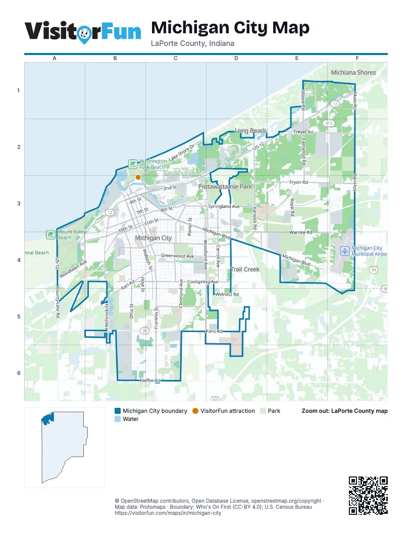
Street index of Michigan City
Each street on the sheet and the grid squares it crosses.
- East Michigan BoulevardB3, C3, D3, D4, E4
- Franklin StreetB3, C4, C5, C6
- US-12E1, F1, D2, E2, C3, A4
- West Michigan BoulevardB3, C3
- 2nd StreetC3
- West 4th StreetB3, C3, A4, B4
- IN-212F3
- Johnson RoadD4
- Meer RoadF1, F2, F3, F4
- Ohio StreetB3, B4, B5, B6
- Wabash StreetB3, B4, C4, C5
- Cleveland AvenueC3, C4, C5, C6
- Springland AvenueC3, D3, E3, F3
- Warnke RoadD4, E4, F4
- Tryon RoadD3, E3, F3
- Lake Shore DriveB2, C2, B3
- Hitchcock StreetB4, B5
- South Woodland AvenueC4, D4, C5
- Greenwood AvenueC4, D4
- East Coolspring AvenueC4, D4
- East Barker AvenueC4, D4
- East 8th StreetB3, C3, D3
- Freyer RoadE2, F2
- Washington StreetB3, B4, C4
- Pahs RoadC5, D5
- Earl RoadB4, C4, B5
- Eastwood RoadE2, E3
- West 10th StreetB3, A4, B4
- West 8th StreetB3, B4
- Pine StreetB3, C3, C4
- Barker RoadC5
- South Karwick RoadD3, D4
- North Karwick RoadD2, D3
- Washington Park BoulevardC2, C3
- South Carroll AvenueD4
- Old Grand Beach RoadE1, F1
- Chicago StreetB3, B4
- West Barker AvenueB4, C4
- West Coolspring AvenueB4, C4
- Moore RoadE1, E2
- West Kieffer RoadB6, C6
- Tilden AvenueC4
- South Roeske AvenueD4
- East Kieffer RoadC6
- East 11th StreetB3, C3
- North Roeske AvenueD3, D4
- Sheridan AvenueA4
- Liberty TrailC3, D3
- Willard AvenueB3, B4
- Duneland Beach DriveE1
- North Carroll AvenueD3, D4
- West 11th StreetB3, B4
- Pleasant AvenueC3, D3
- County Line RoadA4, A5
- Poplar StreetC3, C4
- North Woodland AvenueC3
- South Lake AvenueC2, C3
- Vail StreetC3
- Monroe StreetC3, D3
- Center StreetC2, C3
- Blaine StreetC3
- El Portal DriveF1
- West 2nd StreetB3
- Krueger AvenueC2
- West 900 NorthF2
- West Dunes HighwayA4, B4
- Duneland DriveE1
- South Woodland CourtC3, C4
- Beverly DriveA4
- Grand StreetC3, D3
- West 800 NorthF3
- Heisman HarborB3
- Maple StreetC3, C4, C5
- Oak StreetC3, C4, C5
- Jackson StreetC3, C4, C5
- York StreetC3, C4
- Elston StreetB3, B4
- Manhattan StreetB3, B4
- Woodlawn AvenueA4, B4
- Holliday StreetC3, D3
- Royal RoadE3, E4
- Buffalo StreetB3, B4
- Hoyt StreetB4, B5
- Elm StreetC3, C4
- Lafayette StreetC3, C4
- Boyd CircleC4, C5
- West 9th StreetB3, B4
- West Garfield StreetB4, C4
- Gardena StreetC4
- Frazie RoadE1, F1
- Green StreetB3, B4
- Henry StreetB4, C4
- Walker StreetC3
- Tennessee StreetB3, B4
- Martin Luther King DriveD2
- Southwind DriveB5, B6
- Welnetz RoadC5, D5
- Spring StreetB3, C3
- Meijer DriveC5, C6
- East Homer StreetC4
- West 7th StreetB3
- Kentucky StreetB3, B4
- South Dickson StreetC3, C4
- National BoulevardB5
- Garrettson AvenueC5
- Superior StreetC4
- Dewey StreetC3, C4
- Russell StreetB4
- Village RoadB6, C6
- Dupage StreetC3
- Cedar StreetC3
- Wood Creek DriveE4
- Hobart StreetC3
- Northbrook DriveE1, F1
- Chestnut StreetB5, C5
- Beverly CourtC4
- East 10th StreetB3, C3
- West 6th StreetB3
- Ridgeland AvenueC3, D3
- White Oak DriveD4
- Crestwood DriveB5, B6
- East Garfield StreetC4
- Southwood DriveB5, C5
- West Harrison StreetB4, C4
- Pear StreetC4, D4
- Tremont StreetC3
- Riviera DriveB5
- Saint John RoadB5, C5
- Larkspur LaneC6
- West William StreetB4, C4
- West Ripley StreetB4, C4
- Beachwalk LaneC2
- North Dickson StreetC3
- Fedder DriveB2, C2, B3
- East 9th StreetB3, C3
- Plum StreetC4, D4
- Thurman AvenueC4
- Madison StreetC4
- Pearl StreetC3
- Blue Chip DriveC3
- HuronB3, B4
- South Porter StreetC3, C4
- Benton StreetB4
- North Roeske TrailD3
- Butler StreetC3, C4
- Lake Hills RoadC2
- Main StreetC3
- Bies StreetB4, B5
- Menke RoadE4
- Decatur StreetC4
- Belden StreetC4
- Grace StreetC3
- Fairfield AvenueD3
- Thomas StreetC3, D3
- Kenwood PlaceC4
- Blackberry TrailE3
- Grand AvenueD3
- Hendricks StreetC3, C4
- Childers LaneC2
- Briese LaneE2, E3
- Fir StreetC3
- Wilshire AvenueC4
- East Harrison StreetC4
- Arthur StreetC4
- Twin RoadE2
- East 6th StreetB3, C3
- Esther StreetD3, D4
- Anchor RoadE2
- Cherry StreetC4
- Belle RoadE2
- Tryon Farm LaneE2, E3
- East 7th StreetB3, C3
- Indiana AvenueB4
- South Calumet AvenueD4
- Westwood DriveE1
- Mayfield DriveE3
- Shorewood DriveD2, E2
- Wrobel AvenueC4
- Marine DriveC2, B3
- North Ashland AvenueD3, D4
- North Porter StreetC3
- West Arthur StreetB4, C4
- Park Entrance RoadB2, B3
- Westwind DriveB6, C6
- East 5th StreetB3, C3
- Grant AvenueB3, B4
- North Calumet AvenueD3, D4
- Devonshire CourtD2
- Union StreetC3
- Ferry StreetB4
- Normandy DriveC5
- Rose StreetC3, D3
- E StreetC3
- Bolka AvenueB4
- Lady LaneE1
- Memorial DriveC3, D3
- Redpath AvenueB4, B5
- Short StreetC4
- Jamestown DriveE1
- Joyce AvenueC5
- Amphitheater DriveB2, C2, B3, C3
- Timber TrailE3
- Ramion AvenueB4, B5
- School StreetC3
- Lexington RoadB5
- Euclid AvenueC4, C5
- 2nd PlaceA4
- Douglas AvenueB3, B4
- Emma StreetD3
- Gladys StreetD3
- Hampden RoadB5
- South Park StreetC4, C5
- Nahas StreetD2
- Clover LaneD5
- Lincoln AvenueB3, B4
- Shady LaneD4
- Power LaneC2
- Bristol DriveE1
- Triquad DriveE4
- West Warren StreetB3, B4
- Wolfe AvenueE4
- Tryon StreetC3
- Wildrose DriveF1
- Mall CourtC4
- Ann StreetB4, C4
- North 900 WestC5
- Lawndale PlaceC5
- Salem CourtD4, D5
- Helen StreetC3
- East Fulton StreetC4
- Cloud StreetC3, C4
- Colfax AvenueC2
- Valley Oak DriveB5
- Elmwood DriveE1, F1
- Faulknor StreetD3, D4
- Columbia StreetB4
- Broadbrook LaneB5
- Broadway StreetD3
- Oakwood AvenueC4
- Hollywood AvenueC4
- South Ashland AvenueD4
- Emily StreetC3
- Woodrow AvenueC4
- Salem StreetD4
- Tillottson AvenueB4, C4
- Woodside DriveC5
- Detroit StreetB3, C3
- Elk StreetC4
- Van Spanje AvenueD4
- Elmer StreetC4
- Sanborn StreetC4
- Edward StreetC3
- Concord DriveC4, C5
- Mariner DriveE2, F2
- Meadow DriveF1
- North 600 WestF4, F5
- Ogden AvenueB5
- Sal CourtD4
- Allen StreetC4
- Haack RoadE2
- Belmont CourtC5
- Indian Ridge DriveD4
- Minnie StreetD2
- Fern StreetD2
- Highland AvenueD4
- Greeley AvenueB3, B4
- Dody AvenueD4
- Hawthorne DriveB5
- Silver Lake AvenueA4
- Wall StreetB4
- Providence StreetD4
- North Main DriveF3
- Shorelane DriveE1
- Victory StreetD2
- Davidson AvenueD4
- Winski DriveB4
- Fox Lake AvenueA4
- Long Beach LaneD2, E2
- Golfview RoadE4
- Jefferson StreetC5
- Lupine StreetF1
- Roberta AvenueB4
- Brinkman AvenueB4, C4
- Pinewood TrailE1
- Heisman Harbor DriveB3
- Maplewood DriveE1
- South StreetC4
- Golf LaneE4
- East 4th StreetB3
- Dahlia StreetD2
- Pytynia ParkwayC4
- Pinewood DriveF1
- Autumn Trail SouthC4
- May AvenueB4, C4
- Cedar Lake AvenueA4, A5
- Leeds AvenueE4
- Sunset DriveE4
- Dorchester RoadB5
- Overhill TrailE1
- Fogarty StreetC3
Things to do on the Michigan City map
Places on the map
- Adams Park
- Ames Field Park
- Army National Guard Center
- Barker Middle School
- Barker Woods Nature Preserve
- Bismarck Hill
- Blue Chip Casino
- Blue Chip Casino, Hotel and Spa
- Charles R. Westcott Park
- Crescent Dune
- Crescent Dune Beach
- Dunes Plaza
- Edgewood Elementary School
- Formoer Marquette Mall
- Franciscan Michigan City North
- Gardena Park
- Greenwood Cemetery
- Hanson Park
- Henry Lake Area
- Indiana State Prison
- Isaac C. Elston Middle School
- Joy Elementary School
- Karwick Nature Area
- Knapp Elementary School
- Krueger Memorial Park
- Lake Kai
- Lighthouse Place Premium Outlets
- Marquette Mall
- Michigan City High School
- Michigan City Municipal Airport
- Michigan City Municipal Golf Course
- NICTD Carroll Avenue Yard
- Outer Basin
- Pottawattamie Country Club
- Shirley Heinze Land Trust
- Stribel Park
- Washington Park
- Washington Park Marina
- Waste, Inc.
Next to Michigan City
- Long Beach
- Michiana Shores
- Pottawattamie Park
- Trail Creek
© OpenStreetMap contributors, Open Database License, openstreetmap.org/copyright · Map data: Protomaps · Boundary: Who's On First (CC-BY 4.0); U.S. Census Bureau















