

Indiana map
Silver Creek Township map
About 14,458 people live here (Census Bureau, 2024 estimate). The sheet's index lists 300 streets; County Line Road, State Road 60 and County Road 311 cross the most grid squares. Also on it: Sellersburg, Sellersburg Quarry and Clark Regional Airport.
Open the map (PDF, US Letter)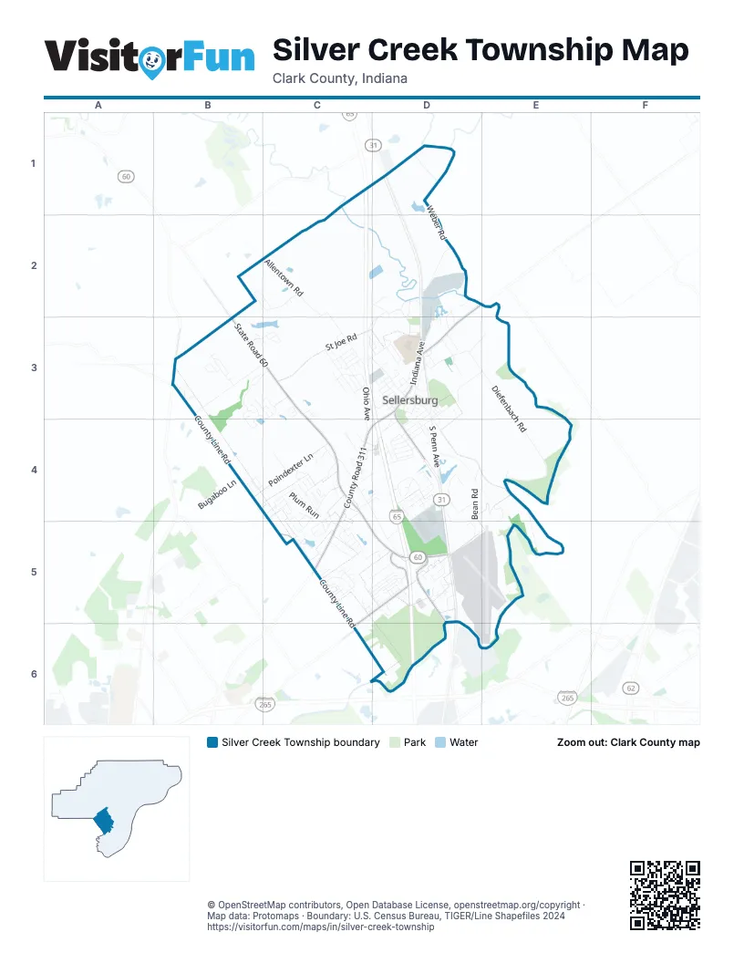
Street index of Silver Creek Township
Each street on the sheet and the grid squares it crosses.
- County Road 311D3, C4, D4, C5
- South Indiana AvenueD3, D4
- North Indiana AvenueD3
- Charlestown RoadC5
- State Road 60B3, C3, C4, C5, D5
- County Road 403D2, D3
- State Road 111B3
- County Line RoadB3, B4, C4, C5, C6, D6
- Payne-Koehler RoadC5, D5, C6
- Appleleaf LaneD5
- East Water StreetD5
- Diefenbach RoadD3, E3, E4
- Weber RoadD1, D2
- Allentown RoadC2, C3
- East St Joe RoadD2, C3, D3
- Utica Sellersburg RoadD4, E4, E5
- West St Joe RoadB3, C3
- Bean RoadD4, E4, D5, E5
- Old State Road 60C4, D4, D5
- Greenleaf RoadD3, E3
- Poindexter LaneB4, C4
- Ohio AvenueC3, C4
- Sterling Oaks DriveB2, C2
- Venice WayB3, C3, B4
- North Fern StreetD3, E3, D4
- South Penn AvenueD3, D4
- East Utica StreetD3, D4
- Elk Run TrailB3, C3
- Lakeside DriveD4
- West Utica StreetC3, D3
- Hunter Station RoadC4
- Twinbrook DriveC4
- Plum Creek DriveC4, C5
- Alabama AvenueC3
- Creek RoadD2
- Progress WayD4
- Silver Glade TrailD4
- North New Albany AvenueD3
- Popp AvenueD3, D4
- Prather StreetC3, D3
- Jefferson BoulevardD5
- South New Albany AvenueD3, D4
- Commerce Park DriveD3
- Dreyer LaneC3, D3
- Meyer LoopC5
- Bugaboo LaneB4
- Palermo TrailB3, C3
- Weidner RoadC2
- Bud Prather RoadD1
- Morning Glory DriveB3
- Georgian AvenueC3
- Camp Run ParkwayC4
- Lake DriveD5
- Deer Run DriveC5
- Plum Woods DriveC4, C5
- Greenwood RoadD5
- Buttercup CircleB3
- Plum RunC4
- Westmont DriveC4, C5
- Riley RoadD2, D3
- Industrial BoulevardD4
- Butler RoadD4
- South Forrest DriveD4
- Celesta WayD5
- St No 23D3
- Clark StreetD2, D3
- Hollkamp WayB3
- Roosevelt DriveC5, D5
- Millian TrailC3
- Joseph DriveC5
- Broadway StreetD3, D4
- Airport DriveD5
- Washington DriveC5, D5
- Cedar Knoll DriveD5
- Plum Valley DriveC4
- South Fern StreetD4
- Villa CircleC4
- Avco BoulevardC5, D5
- Johnson StreetD5
- Allhands AvenueD3
- Meadow DriveC5
- Honey Suckle WayB3
- Diamond HeightsD5
- Wildwood RoadD4
- Nova's Landing DriveC5
- Pennsylvania AvenueC3
- Future DriveC5, D5
- Verona TerraceB3, C3
- Hunters TraceC4
- Virginia HeightsC4
- Beechwood StreetC3, D3
- Penn AvenueD3
- Dovir Woods DriveC4
- Catalpa StreetD3
- Jackson DriveD5
- Mulberry StreetD3
- Twin Springs DriveC4
- Nevada StreetC3
- Antler DriveC5
- Old Bean RoadE4
- Liam Noble CircleC3
- Linwood AvenueD4
- Hampton CourtC3
- North Forrest DriveD4
- Ashby LaneC4, D5
- Eastside AvenueD4
- Plum Lake CourtC5
- Edgewood DriveD4
- South StreetD3
- Clareva RoadD3
- Autumn WayB4
- Plum Ridge DriveC4, C5
- Diefenbach LaneE4
- Locust DriveC4, D4
- Adams Creek DriveC4
- Lincoln DriveD5
- Fulton StreetD4
- Hardy WayC4
- Parallel AvenueD4
- Foothill RoadD4
- Maple StreetD3
- Plum Woods CourtC4, C5
- Eagle Ridge DriveC5
- Kahl StreetD4
- Twin Springs CourtC4
- New Albany PikeC4, D4
- Crystal Spring DriveC4
- Naples WayC3
- Paradise AvenueD3
- Adkins CourtD3
- Victoria DriveC4
- Plum Lake DriveC5
- Florida DriveC3
- Newberry RoadC4
- Terry LaneD5
- Norman DriveD4
- Triangle DriveD3, D4
- Walk DriveD3
- Madison DriveC5, D5
- Messina DriveB3
- Poplar DriveC3, D3
- Millview StreetD3
- St Joe RoadC3, D3
- Indiana AvenueD2, D3
- Catalina TrailB3, C3
- Alden StreetD4
- Haas LaneD3
- Tanner DriveB4
- Wilson LaneD5
- Ehringer LaneD3
- Bower RoadB3, C3
- Mayfair DriveC4
- Bringham DrD4, D5
- Whispering LeafC4
- Emerald DriveD5
- Lasalle StreetD2
- Rachel LaneC4, D4
- Lincoln BoulevardD2, D3
- Hunter Station WayC4
- Highland AvenueD3
- North Norman StreetD4
- Villa DriveD4
- Saint Paul StreetD3
- Denton AvenueC3
- Lane AvenueC3
- Doe RunC5
- Karie DriveD5
- Island CreekB4, C4
- Shadow PointC4
- Shirley AvenueD3
- Indianola StreetD3
- Cedardale DriveC5
- Michigan StreetD2, D3
- High Plains PassB3
- Maple AvenueD3
- Plum Valley CourtC4
- Somerset CourtC4, D4
- Kahl CourtD4
- Forrest Drive NorthD4
- Windsor DriveC4
- Development WayD5
- Allen RoadC3
- Hamburg WayC4
- Edgeland AvenueD3
- Linnwood AvenueD4
- Miners WayD4
- Brandon CircleD4
- Finn Bridge CourtC3
- Oak StreetD3
- Hanger AvenueD3
- South Norman DriveD4
- Renz AvenueD3
- Starview CourtC4
- Carolina AvenueC3
- Caiman CourtC5
- Shagbark TrailB4
- Big Springs CourtC4
- Scheller AvenueD3
- Riley StreetD2
- Kay AvenueD4
- Virginia AvenueD3
- Ice AvenueD5
- Sellers AvenueD3
- Adkins AvenueD3
- Short RoadD3
- Heritage LaneD5
- Church StreetD3
- Maryland StreetD3
- Lisa AvenueD3
- Hauss AvenueD3
- Helbig StreetD3
- Falcon RidgeB4
- Iowa StreetC3
- Alberta CourtD5
- Jacob CourtC3
- Regents Park RoadC3
- Hollowview DriveC5
- Dold AvenueD3, D4
- Sharp's LaneC3
- Sweet Amy WayC4
- Equestian DriveD5
- Scott AvenueC5
- Dora DriveC4
- Enterprise WayC4
- Plum Ridge WayC4, C5
- Soaring Heights CourtC5, D5
- Declaration DriveD5
- Julia AvenueC5
- Patriot LoopC3
- Applegate LaneD3
- Deer Creek DriveC5
- Wapita ValleyC3
- Herb CourtC5
- Samuel DriveC5
- Hillside DriveC4, C5
- Banner AvenueD5
- Buck BoulevardC5
- Danita DriveB3
- Diana DriveC5
- Gilola AvenueD5
- Sutica StreetD3
- Vermont StreetD3
- Blue Sky DriveC5, D5
- Miller AvenueD3
- Reindeer DriveC5
- Midway DriveC3
- Service DriveD3
- Tyler StreetD5
- Angel RunD5
- Onward WayC3
- Circle DriveD3
- Frontier DriveD5
- Plum Run CourtC4
- Settlers DriveD5
- Pin Oaks DriveB2, C2
- Adams DriveD5
- Pauls PlaceD5
- East Delaware CourtC3
- Propeller LaneD5
- Roland DriveC5
- Buchanan DriveD5
- Polk StreetD5
- Hoover DriveD5
- Highpoint CircleC5
- West Delaware CourtC3
- Bucheit StreetD3
- Whitner CourtD4
- Forrest DriveD4
- Lakeside CourtD4
- Arbor CourtC4
- Bridge CourtD4
- Field CourtC5
- High StreetD3
- Meadow LaneC5
- Sunset CourtD4
- Fawn CourtC5
- Oak View DriveC2
- Homestead WayC3
- Andy DriveB4
- Liberty LaneD5
- Cherry StreetD3
- Goldenrod CircleB3
- Sterling TerraceC2
- Bottorff StreetD3
- Plum Tree CourtC4
- Stag CircleC5
- Mt Sterling DriveC2
- Old Highway 111B3
- Virgil CourtC4
- Forest CircleC5
- Brick Church RoadD1
- Hover CourtC5
- Silver StreetC2
- St Joe CourtC3
- Sterling CourtD4
- KentuckyD2
- Beau Vista PlaceD3
- Fox Trail CircleB3
- Doris CourtC4
- Pleasantview CourtC5
Places on the map
- American Legion Park
- Burger King
- Camp Chelan
- Camp Honor Bright
- China Food
- Circle K
- Clark Regional Airport
- Coffee Crossing
- Dairy Queen
- Days Inn & Suites by Wyndham Sellersburg
- Hardee's
- Hendrick Cemetery
- Indiana State Police District 45 – Sellersburg
- IVY Technological Community College of Southern Indiana
- JayC
- KFC
- Marathon
- McDonald's
- Mine
- Old Schoolhouse
- Papa John's
- PNC Bank
- Ramada Sellersburg/Louisville North
- Saint Joseph Hill
- Sellersburg
- Sellersburg Post Office
- Sellersburg Quarry
- Shell
- Sherrilli’s Pizzeria
- Silver Creek School Campus
- Silver Creek Township Park
- Smith Cemetery
- Speed Clay Mine & Plant
- Speed Park
- Starlight
- Stout Elementary School
- Taco Bell
- Waffle House
© OpenStreetMap contributors, Open Database License, openstreetmap.org/copyright · Map data: Protomaps · Boundary: U.S. Census Bureau, TIGER/Line Shapefiles 2024















