

Indiana map
Valparaiso map
About 35,065 people live here (Census Bureau, 2024 estimate). The sheet's index lists 300 streets; Calumet Avenue, West Lincolnway and Vale Park Road cross the most grid squares. Things to do inside the boundary: Brauer Museum of Art.
Open the map (PDF, US Letter)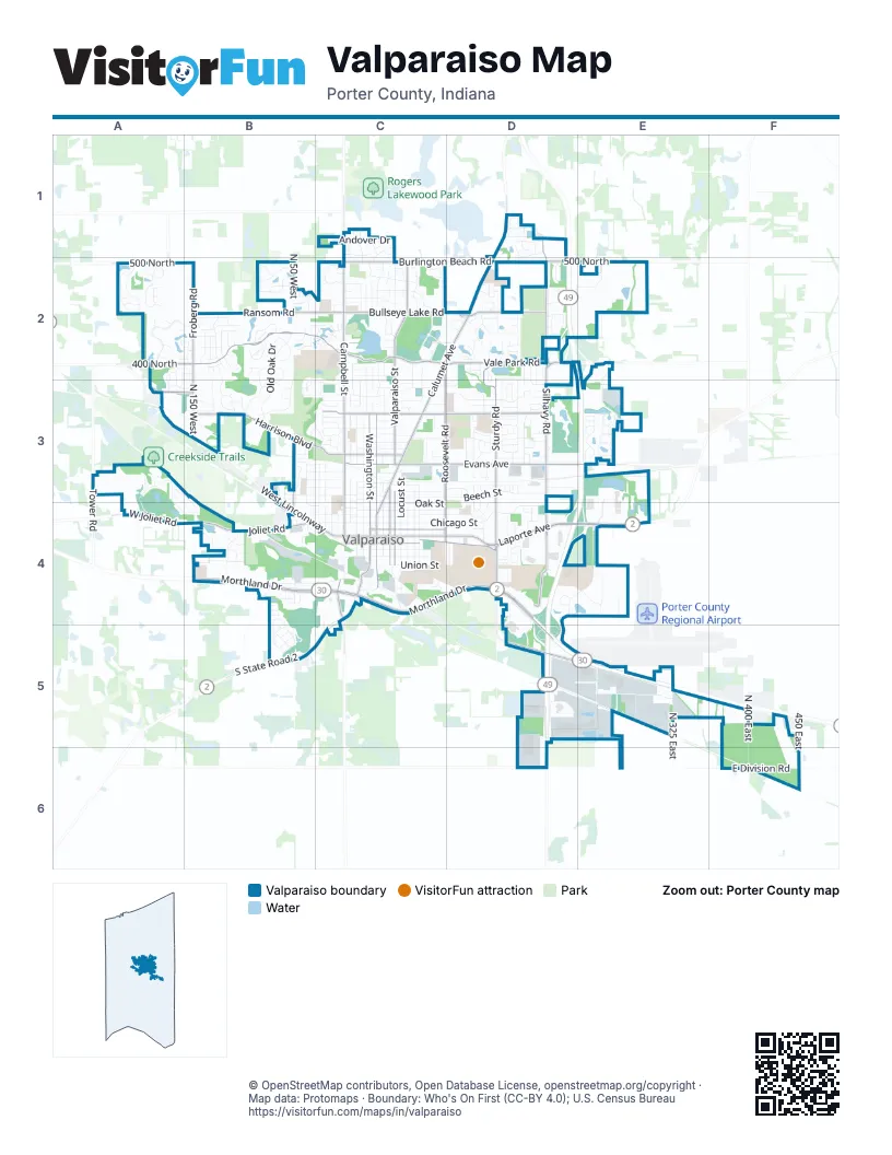
Street index of Valparaiso
Each street on the sheet and the grid squares it crosses.
- East Morthland DriveC4, D4, D5
- Laporte AvenueC4, D4, E4
- West Morthland DriveB4, C4
- Sturdy RoadD2, D3, D4
- West LincolnwayA3, B3, B4, C4
- East LincolnwayC4, D4
- Vale Park RoadB2, C2, D2, E2
- Calumet AvenueD1, C2, D2, C3, C4
- Campbell StreetC1, C2, C3, C4
- Franklin StreetC3, C4
- Burlington Beach RoadC2, D2
- North Washington StreetC3, C4
- Ransom RoadB2, C2
- Froberg RoadB2
- Joliet RoadB4
- Morgan BoulevardC3, C4
- West Joliet RoadA4, B4
- East Jefferson StreetC4
- Indiana AvenueC4
- East 500 NorthD2, E2
- South Washington StreetC4
- South State Road 2B5
- West 400 NorthA2, B2
- East 400 NorthD2
- Silhavy RoadD1, D2, D3, D4
- Valparaiso StreetC2, C3, C4
- Evans AvenueC3, D3, E3
- Harrison BoulevardB3, C3
- Roosevelt RoadC2, D2, C3, C4
- East Glendale BoulevardC3, D3
- Bullseye Lake RoadC2, D2
- North 150 WestB2, B3
- Comeford RoadD5, E5
- West 500 NorthA2, B2
- Yellowstone RoadB3, B4
- North Sturdy RoadD3, D4
- Country Club RoadD2
- Vale Park DriveC2
- West Glendale BoulevardC3
- County Road 375 NorthA3, B3
- Horse Prairie AvenueC4
- Tower RoadA3
- North 175 WestA2
- Smoke RoadC4
- Frontage RoadB4, D4, D5, E5
- East Chicago StreetC4, D4
- Beech StreetC3, D3
- Memorial ParkwayE2, E3
- Pepper Creek Bridge ParkwayA2, B2
- East Division RoadE6, F6
- Lafayette StreetC3, C4
- McCord RoadC3, D3
- Napoleon StreetC3, C4
- Eisenhower AvenueC3, D3
- Institute StreetC4, D4
- Locust StreetC3, C4
- Old Oak DriveB2, B3
- Greenwich StreetC3, C4
- Elm StreetC3, D3
- Garfield StreetC3, C4
- West StreetB4, C4
- Andover DriveC1
- Cumberland DriveC2, C3
- Wood StreetC4, D4
- Sheffield DriveB3, C3
- College AvenueC3, C4
- Brown StreetC4
- Montdale Park DriveE5
- Monroe StreetC4
- Lake Superior DriveE3
- Monticello Park DriveD3
- Park AvenueB3, C3
- Campus Drive SouthC4, D4
- Northview DriveC3
- William DriveB2, B3
- Erie StreetC4
- Eastport Centre DriveD4, E4
- Beulah Vista BoulevardC3
- Michigan StreetC3, C4
- Oak Grove DriveC2
- Kickbush DriveB2
- Oak StreetC4
- Coolwood DriveB4
- Elmhurst AvenueC3, C4
- Sherwood DriveB2, B3
- Danvers ParkwayB4, B5
- Meridian Woods DriveC2
- Pine Creek RoadE3
- Hayes Leonard RoadB4
- North 400 EastF5, F6
- Shamrock LaneA3, B3, B4
- Union StreetC4, D4
- Brander StreetA2
- Del Vista DriveB3, C3
- Green Acres DriveC2
- Center StreetB3, B4
- Hatch Lake ParkwayA3, A4
- Iron Gate DriveA2
- Linwood AvenueC4, D4
- North 50 WestB2
- Porter's Vale BoulevardE3, E4
- West Chicago StreetC4
- Cumberland Crossing DriveC2, D2
- Peachtree DriveD3
- Walker DriveB2
- Madison StreetC3, C4
- Golfview BoulevardC2, B3, C3
- Chandana Trail EastD2
- Bloomingdale AvenueC2
- Galway DriveA3, A4, B4
- Factory StreetB4, C4
- Redbow DriveD4, E4
- Linden DriveC2, C3
- Mc Kinley StreetC3
- Hunters PointeD2
- Axe AvenueC4
- Worthington DriveD2, D3
- West Wind DriveB2
- Brigata DriveA2
- Hemlock DriveC2
- Forest Ridge DriveB2
- Clover LaneC3
- Mayfield AvenueD4
- Byfield ParkwayB4, B5
- Chestnut StreetB4, C4
- Trail Brook DriveB2
- Towne Commons DriveC2
- Jade BoulevardB2
- Bertholet BoulevardD5
- Academy StreetC3, C4
- Manchester DriveB2, B3
- East Port Centre DriveE4
- Appletree LaneC2
- Boca Lago DriveD3
- Wall StreetC3
- Fair StreetC3
- Transport DriveE4
- Nottingham DriveD1
- Weston StreetC3, C4
- Peterson DriveB4
- Milton StreetB3, B4
- West Jefferson StreetC4
- Bond AvenueB3, C3
- Ridgeland AvenueB3, C3
- Albert StreetC3
- Grove AvenueB3, C3
- Powder Horn DriveC2
- Maplewood Mobile Home WorkD4
- Shaker DriveD2, D3
- Victoria DriveC2
- Chapel DriveD4
- Marshall DriveB4
- Winding Brook DriveB2
- Fernhill DriveB3, C3
- Village LaneC2
- Hastings TerraceC2
- Gleneagles BoulevardD2
- Randle StreetC3
- Foggy Glen DriveC2
- Prentiss DriveB2
- White Pine CircleD3
- Finney DriveD2
- Flemming RoadD2
- Blue Grouse StreetD2
- Stirling DriveD1
- Bush StreetC3
- Viking Street SouthB2, C2
- Dorset DriveC2, C3
- Worchester DriveC1
- Berkley DriveC3
- Montdale DriveE5
- Carriage DriveD3
- Diamond BoulevardB2
- North 450 EastF6
- Black Partridge LaneD2
- George StreetB3
- North 325 EastE5
- Sunset DriveC2
- Wicklow DriveB2, B3
- Industrial DriveE5
- Sears StreetC2, C3
- Fordwick LaneC1, C2
- Pepper Ridge RoadA2, A3
- Bogata AvenueB4
- Bartz RoadE3
- Hendon WayB3
- Crockett AvenueD3
- Highland DriveC2
- Viking Drive NorthC2
- Naples DriveB2
- Poplar StreetC3
- Churchview DriveC2
- Whispering Brook LaneB2
- Forest Park AvenueC3
- Summit DriveC2
- Farmdale RoadC2
- Glasgow StreetB5
- Pine Village CircleD2
- Winchester DriveD2
- Lake Michigan DriveE3
- Pennington PlaceD1
- Cascade DriveD3
- Leonard DriveD4
- Concord Square DriveC1
- Lakepointe DriveD2
- Westside Park AvenueB4
- Winter LaneB2
- Rustic Crooked CircleA2, B2
- Beauty Creek DriveB2
- Andover CourtC1
- Killarney LaneA3, B4
- Raystone DriveE5
- Lind LaneD3
- Fairlane DriveC3
- Valley DriveC2, C3
- Willowwood AvenueD2
- Ivy Tech DriveD4, E4
- Thornapple CircleB4
- South 450 EastF6
- Siena DriveA2
- Westbridge DriveD2
- Trailway LaneB2
- Marrell Hill RoadB3
- Southpoint CircleB4
- Truman AvenueD3
- Freeman StreetC4
- Harmel DriveD4
- Marks RoadD4
- Billings StreetC3
- Parkside AvenueD3, D4
- Vine StreetC3
- Ade AvenueD3
- Enterprise AvenueE4
- Shannon DriveC2, C3
- Clear Brook DriveA2, A3
- Indian Summer CircleA2, B2
- Coventry CircleC2
- Bouckingham DriveB2
- Forestside LaneB2
- Ore StreetB4
- Wynnewood DriveB3
- Campus Drive EastD4
- Cedar StreetD3
- Strongbow Centre DriveD4
- Bridgewater DriveD2
- Bedford RoadC1, C2
- Campus Drive WestD4
- McIntyre CourtD4
- Hudson RoadA2, B2, B3
- Somerset DriveC3
- Woodlawn DriveC3
- Elio WayA2
- Virginia Park DriveD2
- Cobblestone DriveB2
- John Glenn DriveC3
- Allison CircleD2, D3
- Crown DriveD2
- Tuckahoe Park DriveD3
- Yorktowne WayD3
- Coachman TrailB2
- Yorktowne DriveD3
- Caspian LaneA2, A3
- Club CourtD2, D3
- St Joseph LaneB4
- Thornapple WayB4
- Roane LaneC3
- Lorraine DriveC3
- Througwoods DriveB2, B3
- Wayne StreetC4
- High Sierra DriveB4
- Urschel DriveD4
- Treaty DriveD2
- Double Eagle LaneD2
- Grand Trunk DriveD3
- Greyfox Drive NorthD2
- Carrsbrooke DriveC3, D3
- Nick DriveE3
- South Campbell StreetC4
- Meadow LaneC3
- Campania DriveA2
- Mariestad DriveB2
- Candlewood DriveB2
- Lancaster DriveC2
- Windsor TrailB2
- Winter Park DriveB2
- Lake Huron DriveE3
- Zao Island Racers Go Kart TrackC4
- Kestrel StreetD2
- Nell DriveE3
- Don Hovey DriveC4
- Kellogg PlaceC3
- Pebble Beach DriveD2, D3
- Clairborne CrossingB2, C2
- South StreetC4
- Pine StreetC3
- Emma CourtE3
- Nickle Plate AvenueC4
- Walnut StreetC3
- Willow StreetC3
- Executive DriveD2
Things to do on the Valparaiso map
Places on the map
- 1st Source Bank
- Aaron's
- Affordable Appliances & Parts
- Aldi
- AmeriPawn
- Athletics-Recreation Center
- Auto Value
- AutoZone
- Batting Cages - Zao Island
- Benjamin Franklin Middle School
- Bicentennial Park
- Blockhead Beerworks
- Christ Lutheran Church
- Fairground Park
- First Presbyterian Church
- Forest Park
- Forest Park Golf Course
- Foundation Meadows
- Glenrose Park
- Glenrose Park South
- Hotter Lagoon
- Immanuel School
- La Cabaña
- Meijer
- Menards
- Northwest Health - Valparaiso
- Porter - Starke Services
- Saint Paul Catholic Church
- Silver Lake
- Soccer and Intramural Fields
- St Andrew's Episcopal Church
- The UPS Store
- Valparaiso Country Club
- Valparaiso High School
- Valparaiso Nazarene Church
- Valparaiso University
- Walmart Supercenter
- West Side Trails
- Westside Park
- Zao Island
© OpenStreetMap contributors, Open Database License, openstreetmap.org/copyright · Map data: Protomaps · Boundary: Who's On First (CC-BY 4.0); U.S. Census Bureau















