

Kentucky map
Madison County map
About 99,582 people live here (Census Bureau, 2024 estimate). The sheet's index lists 300 streets; Boonesborough Road, Menelaus Road and Old Wilderness Trail cross the most grid squares. Also on it: AGC Flat Glass, Alumni Field and AppHarvest - Berea.
Open the map (PDF, US Letter)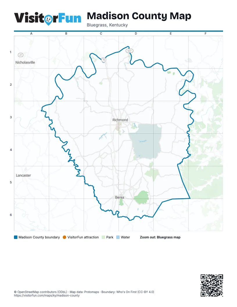
Street index of Madison County
Each street on the sheet and the grid squares it crosses.
- Lexington RoadC1, C2, C3
- Battlefield Memorial HighwayD4, D5, D6
- Irvine RoadD3, E3
- Duncannon LaneC4, D4
- Walnut Meadow RoadC4, C5, D5
- Barnes Mill RoadC3, B4, C4
- Eastern BypassC3, D3
- Lancaster RoadC3, C4
- Paint Lick RoadB5, C5, C6
- Berea RoadD3, D4
- Berea BypassC5, D5, D6
- Dr Robert R Martin BypassC3, D3
- Boonesborough RoadC1, D1, C2, D2
- Richmond RoadD4, B5, D5
- Highway 1016D5
- Big Hill RoadD6
- KY 52C4, B5, C5
- Chestnut StreetC5, D5
- Big Hill AvenueD3
- East Main StreetD3
- Estill StreetD5
- Bighill RoadD5, D6
- Lancaster AvenueC3, D3
- Prospect StreetD5
- West Main StreetC3, D3
- McKee RoadD4
- Richmond Road NorthD5
- US25C5
- Kingston X HighwayD4
- Bybee Loop Y RoadE3
- Waco Y LoopE3
- Tates Creek RoadB2, C2, C3
- Menelaus RoadC4, D4, C5, D5
- Red House RoadD2, D3
- Red Lick RoadD5, E5
- Crooksville RoadD4, E4
- Brassfield RoadE3, E4
- Boonesboro RoadD1, D2
- Speedwell RoadE3, E4
- Caleast RoadC4
- Panola RoadE4
- Mount Vernon RoadC5, C6
- Lost Fork RoadC2, D2
- White Station RoadC5, D5
- Tates Creek AvenueC3
- Glades RoadD5
- South Keeneland DriveC3
- Igo RoadC1
- North 2nd StreetD3
- Menalaus RoadC5
- North Main StreetD5
- Paint Lick SpurB5
- South Main StreetD5
- Dogwood DriveC6
- Main StreetB5
- Dug Hill RoadE4
- Cartersville RoadC6
- College Hill RoadE2, F2, E3
- Jacks Creek RoadB2, C2, C3
- Poosey Ridge RoadB2, B3, B4
- Dreyfus RoadD4, D5, E5
- Whitlock RoadB2, C2, B3
- Maple Grove RoadB3, C3
- Doylesville RoadD2, E2
- Moran Summit RoadC4, B5, C5
- Union City RoadD2, D3
- Kirksville RoadB4, C4, C5
- Four Mile RoadD3
- Moran Mill RoadB4, C4
- Scaffold Cane RoadD5, D6
- Charlie Norris RoadD2, D3, E3
- Blue Lick RoadD5, D6
- Peggy Flats RoadC5
- Colonel RoadC2
- Old Wilderness TrailC2, D2, D3, D5
- John Ballard RoadC4, C5
- Dodd RoadE4
- Old Kingston-Berea RoadD4, D5
- Owsley Fork RoadD6, E6
- Peytontown RoadC4
- Gabbard Town RoadD6
- Short Line PikeD5, D6
- Gibson Bay DriveD3
- Old US 25D5, C6
- East Irvine StreetD3
- Johnson RoadD5
- White Hall Shrine RoadC2
- North 3rd StreetD3
- Ellipse StreetD5
- Old US 25 NorthD5
- West Jefferson StreetC5, D5
- Four Mile AvenueD3
- Madison Hills BoulevardD3
- Republic WayC4
- Old Lexington RoadC3
- Prince Royal DriveC5
- Dodo RoadE4
- Shortline PikeD5
- Daniel W Cloud BoulevardC4
- Lexington Access RoadC2
- West Irvine StreetD3
- Gabbardtown RoadD6
- Chestnut DriveD3
- Clark RoadE5
- Curtis PikeC3, B4, C4
- Avawam DriveC1
- Brookstown RoadD2, D3
- Simpson LaneC1, D1, C2
- Meadowbrook RoadE3, E4
- Walker Parke RoadD2, E2
- Oakley Wells RoadD2, E2, E3
- Dry Branch RoadB3, B4
- Mule Shed LaneB3, C3
- Stoney Run RoadD2, E2
- Carvers Ferry RoadB2
- Hagan Mill RoadC4
- Walter Lakes RoadE4
- Guynn RoadC5
- South Dogwood DriveC5, C6
- Concord RoadD3
- Black RoadE1, D2, E2
- Gumbottom RoadE4, E5
- Gravel Lick Branch RoadE5
- Goggins LaneC3
- Peacock RoadD2
- Hackett PikeD2, D3
- Bogie Mill RoadB3, C3, C4
- Ford RoadD1, D2
- Drowning Creek RoadE3, F3
- Bend RoadE2, F2, E3
- Three Forks RoadC2, D2, D3
- Crutcher PikeC3
- Flint RoadE3
- Combs Ferry RoadD1
- Clay LaneC2
- Boone Trail RoadC2
- Holladay LaneE3
- Jigg Water RoadB3
- Muddy Creek RoadD5
- Goodloe Chapel RoadE4
- Log Cabin RoadD5, E5
- Phelps RoadD1, D2
- Hampton WayC3, C4
- Rosstown RoadB4
- Old KY 52D3, E3
- Cedar Cliff RoadE4, E5
- High Reeves RoadD1, E1, E2
- Greens Crossing RoadD3
- Griggs LaneE3, F3
- Lower Hines Creek RoadC2
- Floyd Branch RoadE5, E6
- Hunter LaneD3
- Mason Lake RoadD6
- Noland RoadD2
- Waco Loop RoadE3
- Bethlehem RoadD5, E5
- Elliston RoadE3
- Lantern Ridge DriveC3
- Forest LaneE3
- Moberly RoadD3, E3
- Whitt RoadE3, E4
- Apache DriveC5, C6
- Pine Grove RoadE4
- Pilot Knob Cemetery RoadD5
- Wolf Gap RoadE5
- Bybee Loop RoadE3
- Arbuckle RoadC4
- Hensley LaneE4
- Catalpa Loop RoadD3
- Newby RoadB3
- Helton LaneB4, C4
- Kentucky River RoadC2
- North Muddy Creek RoadE4, D5, E5
- Ogg LaneD4
- Jolly Ridge RoadB3, C3
- New RoadA3, B3
- East Bill Eads RoadD2
- River Circle RoadC1
- River Hill DriveC1, C2
- Pine Woods RoadD5, E5
- Pineur RoadC2, D2
- Shallow Ford RoadC2, C3
- McCord LaneC3
- East Prong RoadD2
- Hickory Lick RoadE4
- Wallace Mill RoadB5, C5
- Barker Lane WestD5
- Boggs LaneD3
- Fike RoadE3
- Smith LaneD5
- Bob Harris RoadD2
- Burnt Ridge RoadD6
- Opossum Kingdom RoadC5
- Willoughby RoadE2
- High Reeves Spur No 2E1, E2
- Slate Lick RoadC6, D6
- Mayde RoadC5
- Champion WayC4
- Madison Airport RoadC5
- Bear Mountain RoadD6
- Charles White RoadB2
- Golden Leaf BoulevardD4
- Long LaneE4
- Ben Reeves RoadE3
- High Reeves Spur No 1E1, E2
- Cane Springs RoadE2
- Reagan LaneB3
- Todd LaneD3
- Haden HeightsB3, C3
- Burton LaneB3
- Port Royal DriveC2
- Herndon LaneD5
- Redwood DriveC3, C4
- Trace BranchB3
- Kennedy LaneE3
- Jackson Branch RoadB2, B3
- Kit Carson DriveC3, D3
- McCarter BranchE5
- Weddles Mill RoadE2
- Heron Landing PlaceE4
- Hyattsville RoadB4
- Ralph Parks East RoadD2, E2
- Highland Lakes DriveD3
- General Cleburne DriveD4
- Bethlehem SouthD5, E5
- Wildcat DriveC4
- Waco HeightsE3
- Estridge RoadC5
- Fox Town RoadC2
- Eddington LaneB3
- Radford Hollow RoadE6
- Wyldwood WayD5
- Adams LaneC4
- Bethel BranchB2
- Chapel LaneC5, D5
- Boone WayC3
- Windward WayD3
- Primrose CircleD3
- South Eighty Second DriveC4
- East Haiti RoadC6
- Hancock Taylor LaneC3, D3
- Pauline DriveC5
- Fentress LaneD6
- Bill Robertson WayD4
- Davis Hollow RoadD5
- Lewis DriveC3
- Hickory Meadows DriveC2
- Atwood DriveD3
- Long Branch RoadB2, E5
- Stoney Creek WayD5
- Cain Springs RoadE2
- Parrish RoadC4, D4
- Old Town Branch RoadC4
- Dixon Jackson LaneE3
- Woodland Heights RoadB2, B3
- Sandridge Road EastE2
- Lake Reba DriveD3
- Corporate WayD4
- Inverness TrailC1
- Box Ankle RoadD3, E3
- Pin Oak DriveC3, D3, D4, D5
- Campbell Branch RoadD2
- Walnut Hill DriveC3
- Meridian WayC3
- Kavanaugh LaneD3
- Wilson LaneD5
- Mountain View DriveD4
- Concord LaneC4
- Renfro Ridge RoadB2
- Bark RoadE4, E5
- Robbinsville LoopD3
- Foxwood DriveC3
- North Keeneland DriveC3
- Bratcher LaneD6
- Locust Hill RoadE3
- Burley DriveC4
- Martin DriveC3
- Falcon Crest DriveC2
- Brooks RoadC2
- Old Wallaceton RoadC5, C6
- Breezy LaneD4
- Punkin Run RoadD3
- Diamond Brook DriveD3
- Indigo DriveC2
- Riva Ridge RoadC3
- Willis Branch RoadC3
- Pavilion WayD4
- Caroline DriveE3
- Gadwall DriveC2
- Holly Hill RoadC3
- Crossing View DriveD4, D5
- View Point DriveC3
- Barker Lane EastD5
- Foxborough WayC2
- Pine Valley RoadC6
- Pearson LaneD2
- Allen Douglas DriveC4
- West Rice LaneD4
- Moorewood DriveC5
- Amberly WayC3
Places on the map
- AGC Flat Glass
- Alumni Field
- AppHarvest - Berea
- AppHarvest - Richmond
- Avawam Drive
- B-Lake
- Baptist Health Richmond
- Battlefield Park
- Berea
- Berea City Park
- Berea College Forest
- Berea Landfill
- blue
- Blue Grass Army Depot
- Boone's Trace National Golf Club
- Brooks Road
- Buc-ee's
- Camp Catalpa
- Central Kentucky Gun Club
- Cobble Drive
- Cowbell Lake
- Cross Country Trail
- Eastern Kentucky University
- EKU Carnes Farm Trails
- Fort Boonesborough State Park
- Gibson Bay Golf Course
- Hitachi
- Hyster-Yale
- Jd Circle
- KI USA
- Lake Reba
- Lake Reba Park
- Light House Home Products
- Madison County
- Richmond
- Richmond Centre
- Richmond downtown
- Sherwin Williams
- Taylor Fork Ecological Area
- Wilgreen Lake
Next to Madison County
- Lancaster
- Nicholasville
© OpenStreetMap contributors (ODbL) · Map data: Protomaps · Boundary: Who's On First (CC-BY 4.0)