

Louisiana map
Allen Parish map
About 22,501 people live here (Census Bureau, 2024 estimate). The sheet's index lists 300 streets; Highway 26, State Route 26 and 6th Avenue cross the most grid squares. Things to do inside the boundary: Coushatta Casino Resort.
Open the map (PDF, US Letter)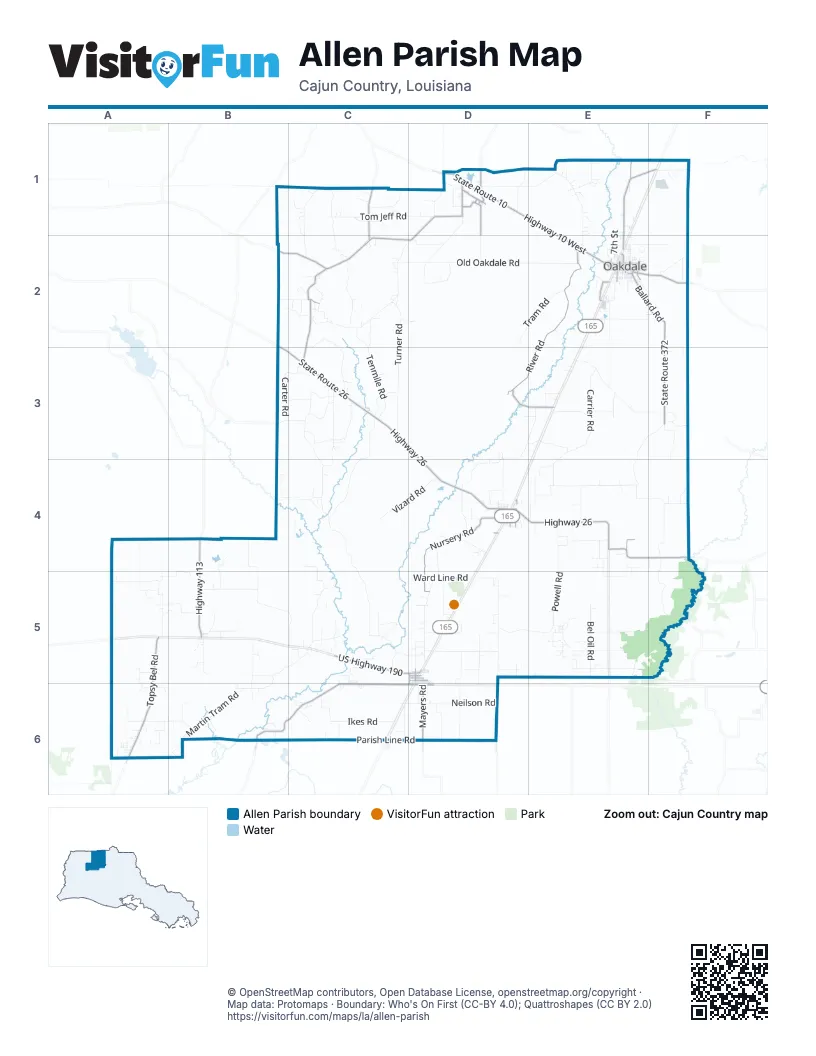
Street index of Allen Parish
Each street on the sheet and the grid squares it crosses.
- Highway 26C3, D3, D4, E4, E5
- State Route 10D1, E2, F2
- Parish Line RoadB6, C6, D6
- State Route 26B2, B3, C3, D4
- Highway 10 WestD1, E1, E2
- US Highway 190C5
- 6th AvenueE2, D4, C5, D5
- 3rd AvenueD4, D5
- 7th AvenueD4
- 8th StreetD4, D5
- North 5th StreetE2, D4
- West 7th AvenueE2, D4
- Highway 10 EastE2
- Oakdale RoadF2
- Pitkin HighwayD1
- Highway 112D1, C2, D2
- Louisiana Highway 383B6, C6
- State Route 377C1, C2, C3
- Highway 113B4, B5
- State Route 104E4, F4
- State Route 112D1, B2, C2
- 1st AvenueC6, D6
- Leroy Duplechain RoadE4
- Bufkin HeightsD1
- K C Smith PickeC2
- State Route 383D6
- Oberlin RoadF4
- State Route 113B4
- South River RoadE2, D3, E3
- Topsy Bel RoadA5, A6
- Nursery RoadD4, D5
- State Route 372F2, F3
- State Route 1153E1, F1, E2
- Ballard RoadE2, F2
- Mayers RoadD6
- Lauderdale HighwayD6
- Reeds Bridge RoadD3, E3
- Highway 377C1, C2
- Main StreetD1, E2
- North Blacktop RoadE1, E2
- East 5th AvenueE2, D4
- Maple StreetD1, E2
- 5th AvenueD4, D5
- Highway 1156D1
- East 7th AvenueE2
- Highway 1152E2
- 4th StreetD4, D5, D6
- Hospital DriveE2
- North 13th StreetE2, D4
- Mimosa DriveD1
- Pine StreetD1, E2, D4
- 4th AvenueD4, D5
- West 6th AvenueE2, D4
- West 4th AvenueD4
- State Route 1151D4
- State Route 3206D1
- Old Pelican HighwayE2
- South 13th StreetE2, D4
- Poplar StreetD1
- Blacktop HighwayE2
- Irene StreetE2
- South 21st StreetE2
- South 5th StreetD4
- Talamas DriveE2
- Parish Rd 566C1
- Highway 3086D6
- Cottongin Castor RoadE4, F4
- Martin Tram RoadB5, C5, A6, B6
- Turner RoadC2, C3
- Carpenters Bridge RoadB4, C4, C5
- Old Oakdale RoadC2, D2, E2
- Powell RoadE4, E5
- Carrier RoadE3, E4
- Walker RoadB4, B5, C5
- Sam Cloud RoadD1, E1, E2
- Musselwhite RoadD3, E3, D4
- Lauderdale Woodyard RoadD5, D6
- North Carpenters Bridge RoadC3, C4
- Simmons RoadC3, C4
- Methodist Camp RoadC4, C5
- Bel Fire Tower RoadA5, B5
- Ward RoadE3, F3
- Norris RoadE2, E3
- Palestine RoadC2
- Tom Jeff RoadC1, D1
- Tenmile RoadC2, C3
- Ikes RoadC6
- Old Main Line RoadD1, D2
- Neilson RoadC6, D6
- Green Oak RoadD5
- Soapstone RoadC1, C2
- Arkadelphia RoadC1, C2
- Gravel Pit RoadC2, B6
- Russell Manuel RoadE3, F3, E4
- Vizard RoadC4, D4
- Carter RoadB3, C3
- Bel Oil RoadE5
- Tram RoadD2, E2
- Briscoe RoadE5, F5
- Ward Line RoadC5, D5
- Alvin Briscoe RoadC2, C3
- Buck Bowles RoadE4
- Bernard Fontenot RoadB5
- Tramel RoadC3
- Unkle RoadD6
- Old Pump RoadC5, D5
- Deshotel RoadE3, E4
- Clyde Chachere RoadD5
- C C Bel RoadD5, E5
- Blue Bush RoadE2
- Allen Cole RoadA6, B6
- Watergate RoadC3, C4
- Willis Corville RoadE5
- Snooky's RoadB5, B6
- Dave Smith RoadC3
- Lapoint Kingrey RoadA4, A5
- Burnett Town RoadA5
- Rodeo Pen RoadB5
- Horseshoe DriveD1
- Lejuene RoadF3, F4
- Neville Vizena RoadD4
- Harrison RoadA5, B5
- Hickory Flat RoadD5
- Guidry RoadF4, F5
- Calvin Willis RoadD1
- Parish Rd 146F5
- Buller RoadE5
- Garcille RoadD3, D4
- Mayfield RoadD6
- East Whatley RoadE2, F2
- Cherry Witchie RoadE1
- Ponderosa RoadE3
- Joe Soignier RoadF2, F3
- Dempsey Langley RoadC5
- Camp Pearl RoadA5, A6
- Burgess RoadC3
- Fontenot RoadE4, E5
- Eloi Ortego RoadD5, D6
- North 7th StreetE1, E2
- Lank Parker RoadA6
- Wolf's Bay RoadD2
- Charlie Kuntz RoadC6
- Dipping Vat RoadE4
- Kinder Cemetery RoadD5
- Mahaffey RoadC3
- Cypress Creek RoadF2
- Fred Ritter RoadB4, B5
- Buddy Doyle RoadD1
- Perimeter RoadE2
- M Fruge RoadD5, D6
- Blackjack RoadC1
- J J Storer RoadD4
- South Lyles StreetB5
- Deer Farm RoadE3
- Clint Simmons RoadC2
- Cole RoadD4, D5
- Grigg RoadC2
- Pawnee RoadF1
- Botley Cemetery RoadD5
- Trammel RoadD2
- Horton RoadC2, C3
- Little Mill RoadC5, C6
- K C Smith RoadB2, C2
- King Hobbs RoadB3, C3
- Wiley Bertrand RoadE3
- Spears RoadD4, E4, C5
- Buddy Moore RoadC1
- 9th StreetE2, D4, D5, D6
- Bay City RoadD1, D2
- Baggett RoadC3
- Meaux RoadE4
- Miguel RoadE4
- 7th StreetD4, D5, D6
- Lovie Garlington RoadC2
- Allen Mahaffey RoadB3, C3
- Darbonne LaneE4
- B and N RoadD1
- 10th StreetE2, D4, D5, D6
- Bond RoadF3
- Kingrey Cemetary RoadB6
- Sonnier RoadE1, E4, E5
- Callahan RoadF2
- Leroy Harper RoadD1
- Duplechain RoadF4
- Bunting RoadC1
- Green Oak Cemetery RoadD5
- Rester RoadC5
- Tyler RoadE2, F2
- Hamilton Cem RoadC2
- Radio Tower RoadC5
- Ellis Bond RoadF3
- Townson RoadC2
- Hargrove Farm RoadE2
- 2nd AvenueD4, D5, D6
- Monceaux RoadA6
- Sawmill RoadB5
- Perkins LaneC2, A5
- Burma RoadB5
- Sand Pit RoadC5
- Martin Luther King DriveE2, D4
- Albert RoadF4
- Cappel RoadC5
- Smokey Savant RoadC6
- Cherry Grove RoadC3
- 6th StreetD4, D5, D6
- North 16th StreetE2
- Sonny's RoadE5
- Braddock DriveE5
- Whitaker RoadB2, C2
- Lyles Cemetary RoadA6
- Everett Young RoadC2
- Marshall Lafleur RoadD5
- Clarence RoadE5
- Papillion RoadE4
- Jessie Johnson RoadC6
- Clyde Chanchere RoadD5
- Robert Sonnier LaneE4
- Indian Church RoadE5
- 3rd StreetD4
- Paul Frank RoadE4
- Crip DuplechainD5
- Griffin LoopD5
- Barnes Creek RoadB6
- 5th StreetD4, D5, D6
- Martin RoadC1, D5
- 14th StreetD5, D6
- Shorty Rawlings RoadC5
- Strangers TreeE5
- Old Ferry RoadB6
- Pine LaneE2, A6
- Coushatta DriveD5, E5
- Ethel Williams RoadE5
- Texas Eastern RoadA6
- Douglas Sonnier RoadD4
- West 9th AvenueD4
- Scott RoadC3
- Vernon Reed RoadD3, E3
- East 6th AvenueE2
- Caskey RoadC3
- Hamilton RoadC4
- Phillpott RoadC1
- Strangers Tree RoadE5
- Camp Coyote RoadE5
- Moncerux RoadD4
- Retreat RoadC5
- East Jackson StreetE2
- Rostrum RoadD5
- Geeter Parker RoadB5
- Legnon StreetB5
- East Dixie StreetE2
- Dunnehoo RoadA5, B5
- Louis Williams LoopC2
- Mount Fair RoadC4
- Fedo Young RoadC3
- 9th AvenueD4, D5
- 11th StreetD4, D5, D6
- Guillory RoadD6
- Tower RoadC2, D2
- Shallow Hole RoadE2
- Rider RoadE4
- Annie Reeves RoadB5
- Elam Langley RoadD5
- Powwow DriveD5
- Ray Shuff RoadE5
- Westland RoadA6
- Oak Hill RoadE1
- 12th StreetD4, D5, D6
- Cottongin RoadD4, E4
- Canton RoadD3, E3
- Tom Quave RoadE1
- Westland DriveA6
- Gladys Houston RoadC1
- Lewis RoadD5
- Chester West RoadE1
- Kingrey RoadA4
- Mill StreetE2
- Adam Guillory RoadE4
- Cow TrailA5
- Harmon LoopD5
- Walter Singleton RoadB4
- Simon Moore RoadE4
- 8th AvenueD4, D5
- Nevils Bluff RoadC6
- North Canal StreetE2
- Richard RoadD5
- Black Jack RoadC1
- White RoadE1, C5
- Lake View LoopC6
- Guillory LoopE3
- Ingalls RoadC1
- 13th StreetD4, D5, D6
- Shorty Odom RoadE1
- Broadwing Ranch RoadE5
- Cooley RoadC3
- Yo Willis RoadE1
- River RoadE2
- Hickory StreetD1, E2
- 16th StreetD4, D5, D6
- North 4th StreetD4
- McFarland RoadD1
Things to do on the Allen Parish map
Places on the map
- Allen Correctional Center
- Allen Parish Airport
- Allen Parish Hospital
- Allen Parish Library Headquarters
- Bear Creek Watershed Number 1
- Bird Pond
- Black Lake
- Botley Cemetery
- Buddy's IGA Foods
- Burger Inn
- Cafeteria
- Carpenters Lake
- Coushatta Tribal Police
- Coushatta Tribe of Louisiana / Kowassaatiha
- Crosby Lake
- Elizabeth
- Elizabeth High School
- Fairview High School
- Federal Correctional Complex (Oakdale, LA)
- Federal Correctional Institution, Oakdale I
- Federal Correctional Institution, Oakdale II
- Grant Post Office
- Kinder
- Kinder High School
- Kinder Post Office
- Kosati Pines
- Le Blanc Post Office
- Oakdale
- Oakdale Community Hospital
- Oakdale Elementary School
- Oakdale Municipal Airport
- Oakdale Post Office
- Oberlin
- Oberlin City Hall
- Oberlin Post Office
- Perimeter Road
- Red Bluff Lake
- Reeves
- Timberlane Landfill
- Wilder Airport
© OpenStreetMap contributors, Open Database License, openstreetmap.org/copyright · Map data: Protomaps · Boundary: Who's On First (CC-BY 4.0); Quattroshapes (CC BY 2.0)















