

Louisiana map
Carencro map
About 12,883 people live here (Census Bureau, 2024 estimate). The sheet's index lists 222 streets; Northeast Evangeline Thruway, Northwest Evangeline Thruway and Veterans Memorial Expressway cross the most grid squares. Also on it: Carencro Park, Cimetiere Saint Pierre and Evangeline Memorial Gardens.
Open the map (PDF, US Letter)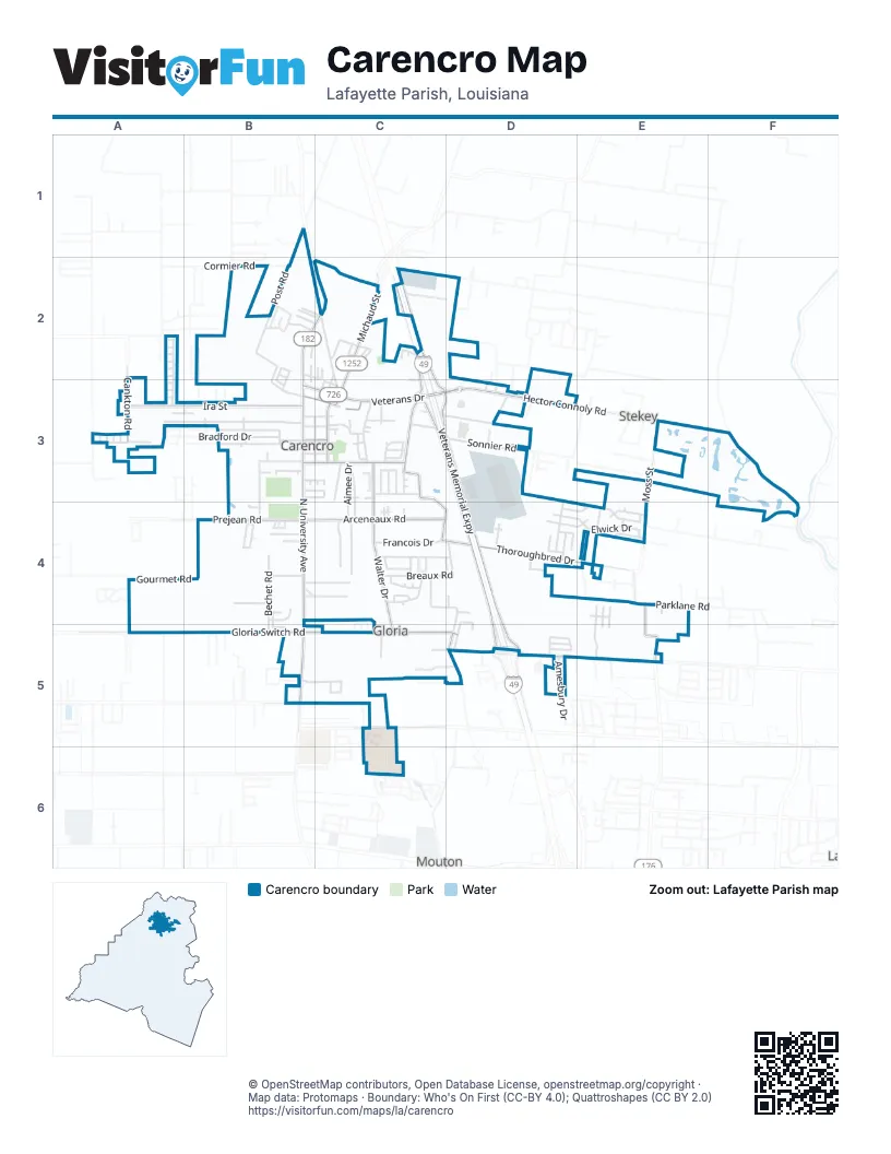
Street index of Carencro
Each street on the sheet and the grid squares it crosses.
- Feather Tail CoveA2
- Grey Feet CoveA2
- Nestling CoveA2
- Pelican Ridge CoveA2, A3
- Seabird CoveA2
- White Stripe CoveA2
- Wingspan CoveA2
- Yellow Bill CoveA2
- 1st StreetB2, B3
- Boxbury CourtB2
- Cainwood CourtB2, B3
- Centenal DriveB2
- Clara StreetB2, C2, C3
- Cormier RoadB2
- Crossfield LaneB2
- Dave StreetB2, C2
- Dunwoody CourtB2
- Fieldview DriveB2, B3
- Greenvale DriveB2, B3
- Lawrence StreetB2, C2
- Meadowvale DriveB2
- North University AvenueB2, B3, B4, B5
- Post RoadB2, B3
- Richard StreetB2
- Sateen Royale CircleB2, C2
- 2nd StreetC2
- 3rd StreetC2
- Carencro StreetC2
- Crouchet StreetC2, C3
- Depot StreetC2
- Dupleix StreetC2
- Fab StreetC2
- Giraud StreetC2
- Huron StreetC2
- North Michaud StreetC2, C3
- North Romero StreetC2
- Northeast Evangeline ThruwayC2, C3, D3, D4, D5
- Northwest Evangeline ThruwayC2, C3, D3, D4, D5
- Railroad StreetC2, C3
- Rue BasinC2
- Rue CalliopeC2
- Rue Des EtoilesC2
- Theo StreetC2
- Veterans Memorial ExpresswayC2, C3, D3, D4, D5
- Calex RoadA3
- Cankton RoadA3
- Ira StreetA3, B3
- Island Nest CoveA3
- Leeward LoopA3
- Nautical RoadA3
- Pelican Haven CoveA3
- Safe Haven DriveA3, B3
- Soaring CoveA3
- St Pierre BoulevardA3, B3
- Starboard LoopA3
- Albert StreetB3
- Albright DriveB3
- Auburn DriveB3
- Bradford DriveB3
- Brockton DriveB3
- Buttonwood DriveB3
- Caleb StreetB3
- East Armand StreetB3, C3
- East Saint Peter StreetB3, C3
- Hardball DriveB3
- Jack StreetB3, C3
- John B StreetB3
- Lombard DriveB3
- MoroccoB3
- Oak Path DriveB3
- Rue BordeauxB3, C3
- Rue Saint MoritzB3
- Saint Anne StreetB3, C3
- Saint Charles StreetB3, C3
- Saint Louis StreetB3, C3
- Tamer AvenueB3
- Tournament DriveB3, B4
- Triple Crown CircleB3, C3
- Veterans DriveB3, C3
- West Armand StreetB3
- West Saint Peter StreetB3
- A StreetC3
- Aimee DriveC3, C4
- Ames CircleC3
- Andre StreetC3
- Armand StreetC3
- B StreetC3
- Belizare StreetC3
- Charles StreetC3
- Church StreetC3
- Clayton StreetC3
- Collins StreetC3
- Damon CircleC3
- Derek Plaza DriveC3
- Estelle DriveC3, C4
- Gregg StreetC3
- Guilbeau RoadC3
- Hector Connoly RoadC3, D3, F3
- Jay RoadC3
- Kay RoadC3
- Mike StreetC3
- North Church StreetC3
- North Saint John StreetC3
- Northpointe DriveC3
- Nydia DriveC3
- Ovide RoadC3
- Pamela StreetC3
- Potier RoadC3, C4, D4
- Raceway StreetC3
- Rainbow StreetC3
- Rampart StreetC3
- Rue AvignonC3
- Rue CielC3
- Rue EnvieC3
- Rue NuageC3
- Rue SoleilC3
- Rue St GaudensC3
- Saint Jacques StreetC3
- Saint Jean StreetC3
- Savant DriveC3
- South Michaud StreetC3
- South Saint John StreetC3
- Teema RoadC3
- Wallace Broussard RoadC3, D3
- Walter DriveC3, C4, C5
- Wilda StreetC3
- Ante Bellum RoadD3
- Coffin RoadD3
- East Angelle StreetD3
- Eloise RoadD3, E3
- Hector Connolly RoadD3
- Philomine RoadD3
- Rue Coupe CiviqueD3
- Schooner Bay DriveD3, D4
- Shelmore StreetD3, E4
- Sonnier RoadD3
- Moss StreetE3, E4, E5
- Beau Bassin RoadF3, F4
- Desoto RoadA4, A5
- Gourmet RoadA4, B4
- Kelso DriveA4
- Ruffian DriveA4
- Arceneaux RoadB4, C4
- Bechet RoadB4
- Kentwood DriveB4, C4
- Prejean RoadB4
- Rue ColombeB4, B5
- Rue PacannierB4
- Sis LaneB4
- Softball DriveB4
- Sosthene RoadB4
- Stemmans RoadB4
- Wisteria Bend CircleB4
- Accordion DriveC4
- Breaux RoadC4, D4
- Bridle WayC4
- Carnival LaneC4
- Fanfare LaneC4
- Festival LaneC4
- Francois DriveC4
- Kate RoadC4
- Marshfield DriveC4
- Ola StreetC4
- Pavilion StreetC4
- Saddle Crest DriveC4, D4
- Smalley RoadC4, D4, D5
- Summerfest DriveC4
- Thoroughbred DriveC4, D4, E4
- Tison RoadC4
- Arabian DriveD4
- Bay Meadow LaneD4, E4
- Burndap WayD4, E4
- Elwick DriveD4, E4
- Four Park RoadD4, D5
- Hollywood Park DriveD4
- Inryco DriveD4
- Jason DriveD4
- Manola DriveD4
- Maymont CourtD4
- Paddock DriveD4
- Pinto DriveD4
- Pixie DriveD4
- Seabiscuit DriveD4
- Stable View DriveD4
- Yonkers DriveD4
- Barnet CourtE4
- Branchwood WayE4
- Emerald Down DriveE4
- Firefly LaneE4
- Leeharr LaneE4
- Lesin Broussard RoadE4
- Meadowland DriveE4
- Moss Bluff DriveE4
- Naval StreetE4, E5
- Parklane RoadE4
- Peppercorn WayE4, E5
- Requisite StreetE4
- Southwell LaneE4
- Wickham StreetE4, E5
- Hernandez RoadA5
- West Gloria Switch RoadA5, B5, C5, D5
- Avron DriveB5
- Elaine DriveB5
- Malapart RoadB5
- Springsteen LaneB5, C5
- Turf RoadB5
- Cotton Field DriveC5
- Lumina DriveC5, D5
- Olaf LaneC5
- Probus LaneC5
- Rupert LaneC5
- Stacey Acres MHPC5
- Titus LaneC5
- Wayfarer WayC5
- West Butcher Switch RoadC5
- Amesbury DriveD5
- Charmonie LaneD5
- East Gloria Switch RoadD5
- Louis Arceneaux RoadD5
- Monica LaneD5
- Sandra LaneD5
- Shar Mon RoadD5
Places on the map
- Barneys Police and Hunting Supplies
- Burger King
- Carencro Catholic School
- Carencro Fire Department
- Carencro Heights Elementary School
- Carencro High School
- Carencro Middle School
- Carencro Park
- Carencro Police Department
- CC's Coffee House
- Cimetiere Saint Pierre
- Dollar General
- Evangeline Memorial Gardens
- exxon
- Fantastic Sams
- Fat Pat's Bar & Grill
- Fontenot Family Dentistry
- GNC
- Kenworth of Louisiana
- McDonald's
- Melancon Pet Grooming
- Merle Norman
- N-V-US Nail Salon
- New Orleans Original Daiquiris
- North Regional Library
- Our Lady of the Assumption Catholic Church
- Pelican Park
- Prejean's
- R & R Car Wash
- Redbox
- Rotolo's Pizzeria
- Saint Peter Catholic Church
- Shoetique
- Stelly, Maestri, & Associates D.D.S.
- Super 1 Foods
- Taco Bell
- Walgreens
- Walmart Pharmacy
- Walmart Supercenter
Next to Carencro
- Mouton
- Stekey
© OpenStreetMap contributors, Open Database License, openstreetmap.org/copyright · Map data: Protomaps · Boundary: Who's On First (CC-BY 4.0); Quattroshapes (CC BY 2.0)















