

Louisiana map
Crowley map
About 11,216 people live here (Census Bureau, 2024 estimate). The sheet's index lists 257 streets; North Parkerson Avenue, West Northern Avenue and West 2nd Street cross the most grid squares. Also on it: Bayou Bend Golf Course, Compass Behavioral Health - Crowley and Acadia General Hospital.
Open the map (PDF, US Letter)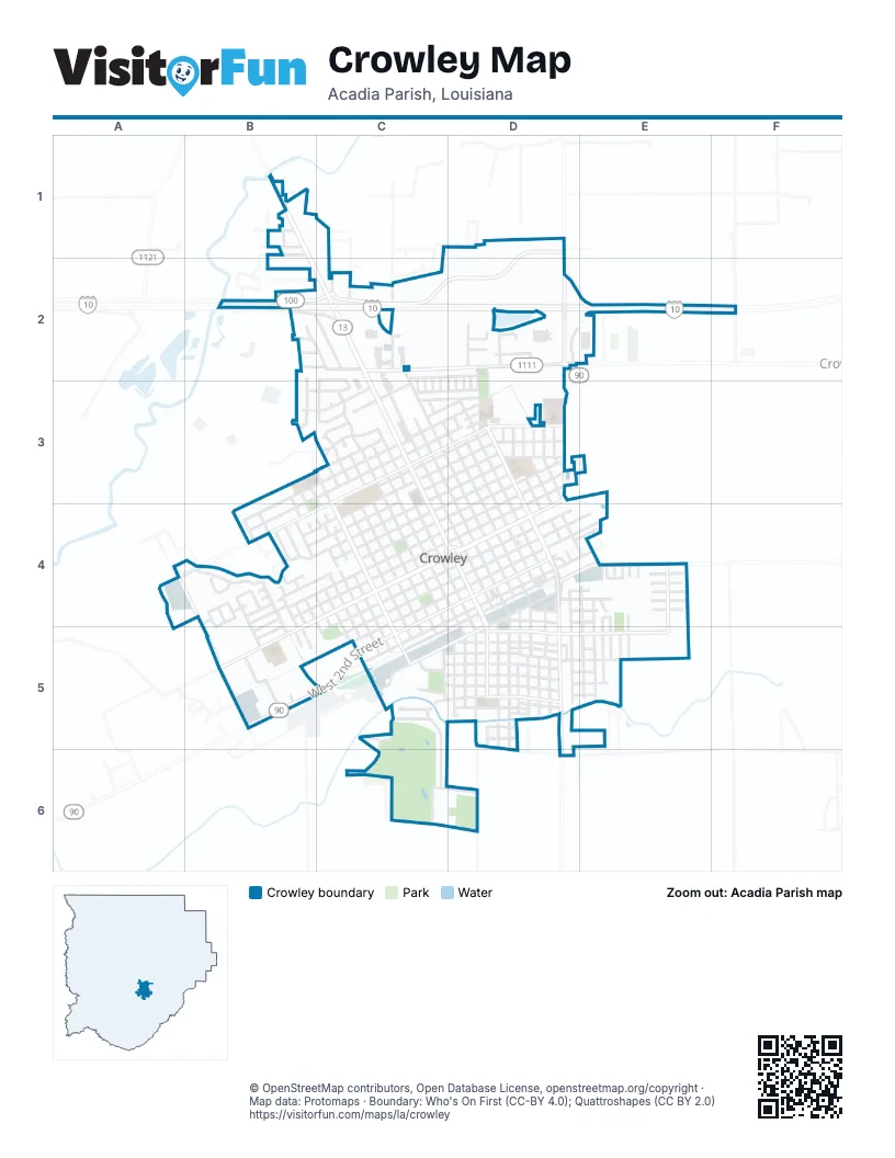
Street index of Crowley
Each street on the sheet and the grid squares it crosses.
- Crowley Eunice HighwayB1, C2
- Forest DriveB1
- Guidry DriveB1
- Pinewood DriveB1
- Pizzolatto DriveB1
- Sherwood LaneB1
- State Route 13B1
- Woodlawn DriveB1
- Stewartville RoadC1, C2
- Markland LaneD1
- Rice Capital ParkwayD1, C2, D2
- Tower RoadD1, D2, D3
- Azalea RoadB2, C2
- Blue Lake DriveB2, C2
- Broadacres DriveB2, C2
- Brook DriveB2
- Cypress DriveB2, C2
- Egan HighwayB2, C2
- Private DriveB2
- V F W DriveB2, C2
- Willow Oaks DriveB2, B3
- Cherokee DriveC2
- Cherry StreetC2, C3
- Dave Bratton LaneC2
- Governor Edwards DriveC2, C3
- James StreetC2, C3
- Judge Canan DriveC2, C3
- Lewis StreetC2, C3
- Marie StreetC2
- North Cherokee DriveC2
- North Parkerson AvenueC2, C3, C4, D4
- Odd Fellows RoadC2, D2
- Rues LaneC2
- Stutes StreetC2, D2
- Sweeney StreetC2, C3
- Canal StreetD2, D3
- Clark CourtD2
- Glenwood AvenueD2
- Greenbriar DriveD2
- Holly StreetD2, D3
- May StreetD2, D3
- Sterling DriveD2
- Texas StreetD2, D3
- Truman StreetD2, D3
- Caffey RoadF2
- Chappuis AvenueB3, C4
- Fairway DriveB3, C3
- Henrietta DriveB3, C3
- Milton AvenueB3, B4
- Taylor AvenueB3, B4
- West 15th StreetB3, C3, B4
- Doris CourtC3
- East 10th StreetC3, D3
- East 11th StreetC3, D3
- East 12th StreetC3, D3
- East 13th StreetC3, D3
- East 14th StreetC3, D3
- East 15th StreetC3, D3
- East 16th StreetC3, D3
- East 17th StreetC3, D3
- East Northern AvenueC3, D3
- East Park StreetC3
- Geesey AvenueC3
- Huval StreetC3, D3
- Huvall StreetC3
- North 17thC3
- North Avenue AC3, C4, C5
- North Avenue BC3, C4, C5
- North Avenue CC3, C4, C5
- North Avenue DC3, C4, C5
- North Avenue EC3, C4, D4
- North Avenue FC3, C4, D4
- North Avenue GC3, C4, D4
- North Avenue HC3, D4
- North Avenue IC3, D3, D4
- North Avenue JC3, D3, D4
- North Western AvenueC3, C4, C5
- Northview LaneC3
- Park StreetC3
- Rue AlineC3
- West 10th StreetC3, B4, C4
- West 11th StreetC3, B4, C4
- West 12th StreetC3, B4, C4
- West 13th StreetC3, C4
- West 14th StreetC3, B4
- West 16th StreetC3
- West 17th StreetC3
- West Bayou CourtC3
- West Bayou DriveC3
- West Northern AvenueC3, A4, B4, C4
- West Park StreetC3
- Western AvenueC3
- 13th StreetD3
- Avenue LD3
- Camelia StreetD3
- Crawford AvenueD3
- Crowley Rayne HighwayD3
- East 6th StreetD3, C4, D4
- East 7th StreetD3, C4, D4
- East 8th StreetD3, C4, D4
- East 9th StreetD3, C4
- East Hutchinson AvenueD3, D4
- Hibiscus StreetD3
- Hockaday StreetD3
- Iris AvenueD3
- Jenkins AvenueD3
- Lake AvenueD3
- North Avenue KD3, D4
- North Avenue LD3, D4
- North Avenue MD3, D4
- North Avenue NorthD3, D4, E4
- North Avenue OD3, E4
- North Avenue PD3
- North Eastern AvenueD3, D4
- William AvenueD3
- Wright AvenueD3
- Capitol AvenueA4, B4, B5
- Palms RoadA4
- Buatt AvenueB4
- Conrad RoadB4
- Dejean CircleB4
- Dr F L Johnson AvenueB4, B5
- Eddie Scott AvenueB4, C4
- Fernwood DriveB4
- Frandel AvenueB4
- Grady Poullard StreetB4
- Hoffpauir AvenueB4
- J D MillerB4
- John F Kennedy DriveB4, B5
- Laurel StreetB4
- Lennie JohnsonB4, B5
- Lurose DriveB4
- Mansfield AvenueB4, C4, C5
- Marcel Thomas AvenueB4, B5
- Meadows LaneB4
- Mockingbird LaneB4
- Service RoadB4
- Spann AvenueB4, C4, C5
- Stagg AvenueB4, C4, C5
- Valien AvenueB4
- West 6th StreetB4, C4
- West 7th StreetB4, C4
- West 8th StreetB4, C4
- West 9th StreetB4, C4
- Westside AvenueB4
- Westwood DriveB4
- William Egan AvenueB4
- Jacob AvenueC4
- Jacobs AvenueC4, C5
- Kilmer StreetC4
- Moore AvenueC4, C5
- Northwest Court CircleC4, D4
- Ross AvenueC4, C5
- Smith StreetC4
- West 1st StreetC4, D4, C5
- West 2nd StreetC4, D4, B5, C5
- West 3rd StreetC4, D4, C5
- West 4th StreetC4, D4, C5
- West 5th StreetC4, D4, C5
- West Hutchinson AvenueC4, D4, B5
- East 1st StreetD4, E4
- East 2nd StreetD4
- East 3rd StreetD4, E4
- East 4th StreetD4, E4
- East 5th StreetD4
- East Clay StreetD4, E4
- East Front StreetD4
- East Mill StreetD4, D5
- Hargrave StreetD4, E4
- Lawson StreetD4, E4
- Mear StreetD4, E4
- Mill StreetD4
- Northeast Court CircleD4
- Riceland DriveD4, E4
- South Avenue ED4, D5
- South Avenue FD4, D5, D6
- South Avenue GD4, D5
- South Avenue HD4, D5, D6
- South Avenue ID4, D5
- South Avenue JD4, D5
- South Avenue KD4, D5
- South Avenue MD4, D5
- South Eastern AvenueD4, D5, D6
- South Parkerson AvenueD4, D5
- Standard Mill RoadD4, E4
- West Front StreetD4, C5
- Blue Bonnet DriveE4
- Blue Rose DriveE4
- Constantin DriveE4
- Dorn StreetE4
- Dronet StreetE4
- DustE4
- Easley StreetE4
- East Andrus DriveE4, E5
- East Hargrave StreetE4
- East Park DriveE4, E5
- Green StreetE4
- Gulf Rose DriveE4
- Josey StreetE4, E5
- Labelle DriveE4
- Pintail DriveE4
- S Avenue NorthE4, E5
- Senegal StreetE4
- South Avenue OE4, E5
- West Andrus DriveE4, E5
- Wilson StreetE4
- American Legion DriveB5
- Findale DriveB5
- Grace Pete StreetB5
- Jack Mitchell AvenueB5
- New RhoneB5
- Roller RoadB5
- State RoadB5
- Bayou Oaks DriveC5
- Camp StreetC5
- East Hoyt AvenueC5, C6
- Fir AvenueC5
- Front StreetC5
- Oscar Johnston DriveC5
- South Avenue CC5
- South Avenue DC5, D5
- South Western AvenueC5
- West Ash StreetC5, D5
- West Elm StreetC5, D5
- West Hoyt AvenueC5, C6
- West Jeanette StreetC5, D5
- West Mill StreetC5, D5
- West Pine StreetC5, D5
- West Spruce StreetC5, D5
- East Ash StreetD5, E5
- East Cedar StreetD5, E5
- East Elm StreetD5, E5
- East Jeanette StreetD5, E5
- East Oak StreetD5, E5
- East Pine StreetD5
- East Spruce StreetD5, E5
- East Walnut StreetD5
- Guilbeau LaneD5
- Gum StreetD5
- Hunter DriveD5, E5, D6
- Keller StreetD5
- Lagrange StreetD5
- Magnolia StreetD5
- South Avenue LD5
- Trahan StreetD5
- Utility RoadD5
- Walnut AlleyD5
- West Cedar StreetD5
- West Lovell StreetD5
- West Oak StreetD5
- West Walnut StreetD5
- Hunter RoadE5
- Mims DriveE5
- Bruner AvenueC6
- Buck Sweeney DriveC6, D6
- Edgewood DriveC6
- East Lovell StreetD6
Places on the map
- (Old) Crowley Cemetary
- Acadia General Hospital
- Acadia Parish Courthouse
- Acadia Parish Police Jury
- Acadia Parish Public Library
- Bank of Commerce & Trust Company
- Bayou Bend Golf Course
- Bicentennial Park
- Chevron
- Chili's
- Church of Christ in Crowley
- Compass Behavioral Health - Crowley
- Crowley City Hall
- Crowley Historic District
- Crowley Kindergarten School
- Crowley Post Office
- Days Inn by Wyndham Crowley
- Donut Queen
- DQ Grill & Chill
- Duson Park
- Edwards Park
- First National Bank
- Hoffpauir Park
- Immaculate Heart of Mary Catholic Church
- Kingdom Hall of Jehovahs Witnesses
- Levy Park
- Local Supermarket
- Louisiana National Guard
- Lowe's
- Martin Luther King Park
- McDonald's
- Miller Stadium
- North Crowley Elementary School
- Northside Assembly of God Church
- Notre Dame High School
- Old Frisco / Missouri Pacific / Southern Railway Station
- Old Southern Pacific Railway Station
- Ross Elementary School
- Woodlawn Cemetery
- Young's Centre
© OpenStreetMap contributors, Open Database License, openstreetmap.org/copyright · Map data: Protomaps · Boundary: Who's On First (CC-BY 4.0); Quattroshapes (CC BY 2.0)















