

Louisiana map
Lake Charles map
About 81,157 people live here (Census Bureau, 2024 estimate). The sheet's index lists 300 streets; East Prien Lake Road, West Prien Lake Road and Bord du Lac Drive cross the most grid squares. Things to do inside the boundary: Golden Nugget Lake Charles and L'Auberge Casino Resort Lake Charles.
Open the map (PDF, US Letter)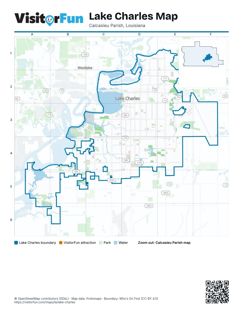
Street index of Lake Charles
Each street on the sheet and the grid squares it crosses.
- Ryan StreetD2, D3, D4
- East McNeese StreetD4, E4
- North Martin Luther King HighwayE1, E2
- Fruge StreetD2, E2
- Gerstner Memorial HighwayE3, E4
- North Lakeshore DriveC2, D2, D3
- West McNeese StreetB4, C4, D4
- Belden StreetD2, E2
- Nelson RoadC4, C5
- I-10 Service RoadD2, E2
- Gerstner Memorial DriveE2, E3, E4
- Veterans Memorial BoulevardD2
- Clarence StreetD3
- South Martin Luther King HighwayE2
- Highway 171E1
- South Lakeshore DriveD2, D3
- Martin Luther King HighwayE1
- Enterprise BoulevardD2, D3, D4
- East Prien Lake RoadF3, D4, E4, F4
- Broad StreetD2, E2, F2
- West Prien Lake RoadB4, C4, D4, B5
- Common StreetD3, D4, D5
- Louisiana AvenueD2, D3, D4
- Lake StreetC3, C4, C5
- Country Club RoadB5, C5
- West Sale RoadB4, C4, D4
- Big Lake RoadB5, B6
- East Ward Line RoadF3, F4
- 12th StreetD3, E3
- Opelousas StreetD2, E2
- Legion StreetD3, E3
- University DriveC4, D4, C5
- North Lincoln StreetE1, E2
- Cove LaneB3, B4
- Timberline DriveE2
- Pamco RoadE2
- North Enterprise BoulevardD2
- East Sallier StreetD3
- Enterprise BoulevadD4
- I- 10 Service DriveD2
- 5th AvenueD2, D3, D4
- Kirkman StreetD2, D3, D4
- West Sallier StreetC3, D3
- North Goos BoulevardD1, D2
- Oak Park BoulevardD3, E3
- East College StreetD4
- Ernest StreetC3, C4
- 4th AvenueD2, D3, D4
- 2nd AvenueD2, D3, D4
- Weaver RoadB4, B5, C5
- Power Centre ParkwayD4, E4
- 7th StreetD3, E3
- Contraband ParkwayC3, C4
- Shell Beach DriveC3, D3
- Simmons StreetE1, E2
- North Shattuck StreetD1, D2
- Fitzenreiter RoadD1, E1
- Avenue L'AubergeB3, C3, C4
- Moeling StreetD2, E2
- Sen J Bennett Johnston AvenueE2, E3
- Golden Nugget BoulevardB3, C3, C4
- L'Auberge BoulevardC3, C4
- East School StreetD4
- West 18th StreetC3, D3
- Holly Hill RoadC4
- 6th AvenueD2, D3
- South Shattuck StreetD2
- Doctor Michael Debakey DriveC3, D3
- Alamo StreetD3
- Lisle Peters RoadA5, B5
- Kirby StreetD2, D3
- West School StreetC4, D4
- West College StreetC4, D4
- Haymark RoadA6, B6
- Bunker RoadE2
- West Gauthier RoadB6
- Admiral King StreetE3, E4
- Ham Reid RoadB5
- Alvin StreetC3
- Corbina RoadE4
- Siebarth DriveE3
- Ihles RoadB4
- East Sale RoadD4
- Elliott RoadB5
- Lake Shore DriveD3
- 1st AvenueD2, D3, D4
- Hodges StreetD2, D3, D4
- 11th StreetD3, E3
- Mallard Cove StreetE3, F3
- 6th StreetD3, E3
- Bank StreetD2, D3
- 10th StreetD3, E3
- 18th StreetD3, E3
- Graywood ParkwayA5, B5, B6
- 17th StreetD3, E3
- 9th StreetD3, E3
- 3rd AvenueD2, D3, D4
- Jefferson DriveC4, D4, D5
- 14th StreetD3, E3
- 13th StreetD3, E3
- 8th StreetD3, E3
- Center StreetD3, D4
- 3rd StreetD3, E3
- North Prater StreetD1, D2
- Moss StreetD2, D3
- Mill StreetD2, E2
- Jackson StreetD2, E2
- Bilbo StreetD2, D3
- Creole StreetC3, C4
- North Booker StreetD1, E1, D2
- North Grace StreetE1, E2
- Ford StreetD2, D3
- 7th AvenueE3, E4
- Medora StreetD1, E1
- Cessford StreetD2, E2
- Church StreetD2, E2
- 2nd StreetD3, E3
- Reid StreetD2, D3
- 15th StreetD3
- Central ParkwayC4, C5
- North 1st AvenueD2
- Commercial StreetD2, E2
- Pear StreetD1, D2
- 5th StreetD3
- Pine StreetD2
- Lawrence StreetD2
- 4th StreetD3, E3
- 20th StreetD3, E3
- 21st StreetD3, E3
- Gray Plantation DriveA5, A6
- North Jake StreetE1, E2
- Gieffers StreetD2, E2
- River RoadC2, D2
- North River Road StreetC2, D2
- 16th StreetD3
- Hagan StreetD1, E1
- Katherine StreetD2, E2
- North Railroad AvenueD2
- Greinwich BoulevardE4
- 23rd StreetD3, E3
- 22nd StreetD3, E3
- Ashland StreetC4, C5
- Contour DriveC4, D4
- West Tank Farm RoadB6
- Rose StreetD3, E3
- West Claude StreetC4, D4
- Smith RoadD5, E5
- 1st StreetD3
- Cline StreetD2, E2
- Fournet StreetD2
- North Blake StreetD2
- South Railroad AvenueD2, E2
- Bord du Lac DriveC2, D2, C3, D3
- Elms StreetC3, D3
- North Lyons StreetD2
- Avenue JE3
- West Lagrange StreetC4, D4
- North Cherry StreetD2
- See StreetD2, E2
- Adams StreetE1, E2
- Desoto StreetD4, D5
- Gray Market DriveA5, B5
- Dolby StreetC5, D5
- Auburn StreetD4
- Junior StreetD1, D2
- Aster StreetD3, D4
- Main StreetE2, E3
- South Park DriveD4
- Cactus DriveD4
- Louie StreetC3, D3
- Penn StreetC3, D3
- Deaton StreetD3, D4
- Orchid StreetD3, E3
- Division StreetD2
- Orchard DriveC4, D4
- Pujo StreetD2
- Cypress StreetC3
- Martha StreetD2
- Harvard StreetD4
- Tulane StreetD4
- Winterhalter StreetD2
- Texas StreetD4
- Channel StreetD2, E2
- Craft StreetD3
- Canal StreetC4, C5
- Iris StreetD3
- 8th AvenueE2, E3
- Sawgrass WayA5
- Clover DriveD4
- East Parkway StreetD4, D5
- Arlington DriveD4, D5
- West Oak LaneC4, D4
- West Hale StreetC3, D3
- Washington StreetD4, D5
- Saint John StreetD2
- Harless StreetD1, E1
- Barbe StreetC3
- Illinois StreetD4
- Boston StreetD2
- Kiwanis LaneB4
- South Franklin StreetD2
- Warren AvenueD3, D4
- Mary Ann StreetF3, C4
- Mallard CoveE3, F3, F4
- V E Washington AvenueD2
- Orrin StreetD1, D2
- Henderson Bayou RoadB4
- Sunset DriveD4
- Evans StreetD2
- Cathy StreetE1, E2
- Kingsley StreetE2
- Willowick StreetD4
- Graham StreetE1
- South Cherry StreetD2
- Morningside DriveC5, D5
- South Lyons StreetD2
- Derek DriveE4
- Helen StreetC3, D3
- Pleasant DriveC4
- Goos StreetD2
- General Patton StreetE3, E4
- Knapp StreetD1, E1
- Sally Mae StreetE1, E2
- Kingston StreetC4
- Taylor StreetE4
- Van Buren StreetD4, E4
- Crestwood StreetC5
- Greenway StreetC5, D5
- Pithon StreetD2, D3
- Elaine StreetD2, E2
- Palmetto DriveA6, B6
- West Quail Hollow DriveB4, B5
- Woodring StreetD1, E1
- Dixy DriveC3
- East la Grange StreetD4
- East Quail Hollow DriveB4, B5
- Esplanade StreetD5
- Woodard StreetD1, E1
- Armstrong StreetE2
- Conoco StreetE1
- Cleveland StreetD3
- McNeese Farm RoadE4
- Mitchell StreetD4
- Mc Nabb StreetE3
- Orange StreetD3
- California StreetD4
- Fall StreetD3
- Gulf StreetD3
- Sale LaneC4, C5
- Arkansas StreetD4
- McNabb StreetE2
- Chennault ParkwayE3, F3
- Sugarloaf DriveE4
- Sycamore StreetD3
- East Mill StreetD2, E2
- Sassafras WayA5, B5, B6
- Heather StreetC5
- Vanessa AvenueC5, D5
- Tulip StreetD3, E3
- Vanderbilt StreetD4
- Royal StreetD4, D5
- Meadow DriveD4
- Sage DriveD4
- 19th StreetD3, E3
- North General Wainwright DriveE3
- Lafanette RoadB5
- Hillcrest DriveE3
- Gelpi DriveE3
- Portrush DriveB4, B5
- Overhill DriveC5, D5
- Live Oak StreetD3
- McKinley StreetE4
- Petro Point DriveD5
- Egret StreetE2, E3
- Railroad AvenueD2
- Old Highway 171 NorthE1
- North Blue Heron DriveE3
- East StreetD3
- General Doolittle AvenueE3
- Joe Spears RoadF3
- Stanton StreetD3
- Broadmoor DriveE3
- Dewey StreetD2, E2
- Giovanni StreetC3
- Mary StreetE1
- White Oleander Drive WestA5, A6
- Brentwood StreetD4
- Swanee StreetD4
- Mount Talbot StreetE2
- North Malcolm StreetE1, E2
- Wendell StreetE1, E2
- West Roosevelt StreetD4, E4
- Maid Stone DriveB4
- Deesport StreetC3
- Prospect StreetE3, F3, D5
- 9th AvenueE3
- South Goodman RoadE2
- Albert StreetD2
- North Franklin StreetD2
- General Marshall StreetE3, E4
Things to do on the Lake Charles map
Places on the map
- Barbe High School
- Boardwalk Park
- Chennault International Airport
- Combre Memorial Park
- Drew Park
- Eastside Post Office
- F K White Middle School
- Golden Nugget Lake Charles Hotel & Casino
- Gray Plantation Golf Course
- Huber Park
- L Auberge Du Lac Hotel Seaplane Base
- L'Auberge Casino Resort Lake Charles
- LaGrange High School
- Lake Area Hospital
- Lake Charles Memorial Hospital
- Lake Charles Multi-Sports Complex
- Lake Charles Post Office
- LeFleur Park
- Mallard Cove Golf Course
- McNeese State University
- Millennium Park
- Molo Middle School
- Nelson Elementary School
- Nelson Road Park
- North Beach
- Oceans Behavioral Hospital Of Lake Charles
- OD Johnson Baseball Fields
- Orange Grove Cemetery
- Perkins Ferry Park
- Prien
- Prien Lake Mall
- Prien Lake Park
- Prien Memorial Park Cemetery
- The Country Club at Golden Nugget
- The Mail Bar and Printery
- The UPS Store
- Tuten Park
- Walmart Supercenter
- WH Buddy Prejean Memorial Park
Next to Lake Charles
- Westlake
© OpenStreetMap contributors, Open Database License, openstreetmap.org/copyright · Map data: Protomaps · Boundary: Who's On First (CC-BY 4.0); Quattroshapes (CC BY 2.0)