

Louisiana map
Morgan City map
About 10,813 people live here (Census Bureau, 2024 estimate). The sheet's index lists 203 streets; Railroad Avenue, Federal Avenue and LA 70 cross the most grid squares. Also on it: Lake End Park, Ochsner St. Mary Hospital and Brownell Memorial Park.
Open the map (PDF, US Letter)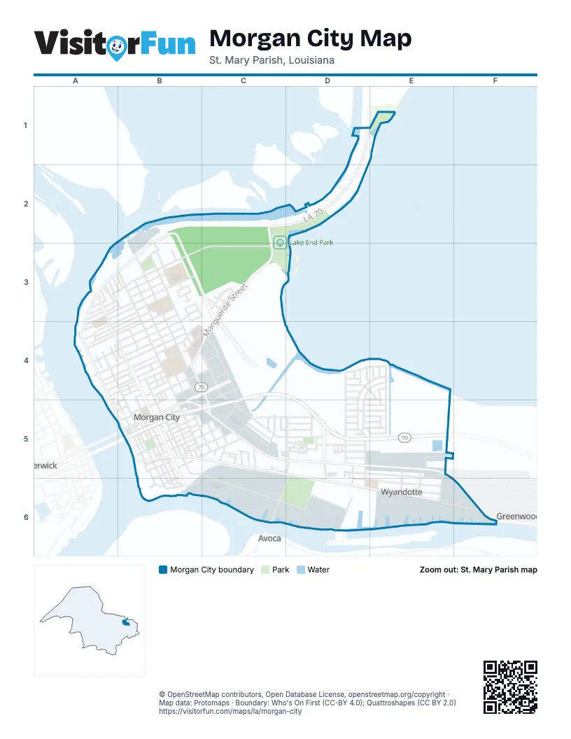
Street index of Morgan City
Each street on the sheet and the grid squares it crosses.
- LA 70D1, C2, D2, C3
- Levee RoadB2, A3, B3, A4
- Shaw DriveB2, B3
- Acorn StreetA3, B3
- Apple StreetA3
- Clements StreetA3
- Cypress StreetA3
- Egle Mill LaneA3
- Federal AvenueA3, A4, B4, B5, B6
- Fig StreetA3, B3, C3
- Garber StreetA3
- Laurel StreetA3
- Lawrence StreetA3
- Leona StreetA3, B3, A4
- Orange StreetA3, B3
- Pecan StreetA3, B3
- Tupelo StreetA3, B3
- Willow StreetA3, B3
- 6th StreetB3, B4, B5, C5
- Aucoin StreetB3, A4, B4
- Bush StreetB3, A4, B4
- Cedar StreetB3, B4
- East Garner DriveB3
- Elm StreetB3, B4
- Fir DriveB3
- Franklin StreetB3, A4, B4
- Hemlock StreetB3
- Hickory StreetB3
- Hilda StreetB3, B4
- Louisa StreetB3, A4
- Maple StreetB3, B4
- Marquis ManorB3
- North Prescott DriveB3
- Onstead StreetB3, A4, B4
- Palm StreetB3
- Poplar StreetB3
- Sacred Heart DriveB3
- Shaw StreetB3
- South Prescott DriveB3
- Sycamore StreetB3
- Veterans BoulevardB3, C3, C4
- West Garner DriveB3
- Canary StreetC3
- Cardinale StreetC3
- Dove StreetC3
- Mallard StreetC3
- Marguerite StreetC3, B4, C4
- Oriole StreetC3
- Robin StreetC3
- Wren StreetC3
- 2nd StreetA4, B4, B5, B6
- Belanger StreetA4, B4
- Bowman StreetA4, B4
- Brownell StreetA4, B4
- Egle StreetA4, B4
- Ellzey StreetA4, B4
- Front StreetA4, A5, B5
- Montana StreetA4, A5
- North 1st StreetA4
- North 3rd StreetA4
- Terrebonne StreetA4, B4
- Utah StreetA4
- 3rd StreetB4, B5, B6
- 4th StreetB4, B5
- 5th StreetB4, B5
- 7th StreetB4, B5, C5
- 8th StreetB4, B5, C5
- 9th StreetB4, C4, C5
- Arenz StreetB4
- Arizona StreetB4, B5, B6
- Arnez StreetB4
- Ash StreetB4
- Brashear AvenueB4, C4, B5
- Chester Bowles StreetB4
- Clothilde StreetB4, C4
- Dora StreetB4
- Dugas StreetB4, A5, B5
- General Clark StreetB4
- General Hodges StreetB4
- General McArthur StreetB4
- General Patton StreetB4
- Grove StreetB4, B5
- Idaho StreetB4, B5
- Julia StreetB4
- Kidd StreetB4
- Lakewood DriveB4
- Marshall StreetB4
- Mayon StreetB4
- Missouri StreetB4, B5
- Pine StreetB4
- Shannon StreetB4
- Songe StreetB4
- Spruce StreetB4
- Victor II BoulevardB4, C4, C5, D5
- Willard StreetB4
- David DriveC4, C5
- Greenwood StreetC4, B5, C5
- Kenneth StreetC4
- Azalea DriveD4
- Carrol DriveD4
- Chestnut DriveD4, E4, D5
- Diane DriveD4, E4
- Glenmont DriveD4
- Justa StreetD4, D5
- Lake Palourde DriveD4, E4
- Lesley DriveD4
- Lizabeth DriveD4
- McDermott DriveD4, E4, D5
- Ridgeway DriveD4
- Tammy DriveD4, E4
- Chatsworth DriveE4, E5
- Parlange DriveE4
- Walnut DriveE4, E5
- Willow Bend DriveE4
- Ann DriveA5, B5
- 1st StreetB5, B6
- Adams StreetB5, B6
- Alabama StreetB5
- Arkansas StreetB5, B6
- Barrow StreetB5, B6
- Ditch AvenueB5, C5
- Drackett AlleyB5
- Duke StreetB5, C5
- Everett StreetB5, C5
- Florence StreetB5, C5
- Florida StreetB5
- Freret StreetB5
- Iowa StreetB5
- Kansas StreetB5
- Kentucky StreetB5
- Louisiana StreetB5
- Maine StreetB5
- Maryland StreetB5
- Michigan StreetB5
- North Everett StreetB5
- Pershing StreetB5
- Railroad AvenueB5, C5, D5, D6, E6, F6
- Saint Clair StreetB5
- South Everett StreetB5
- South Railroad AvenueB5
- Union StreetB5
- Wise StreetB5
- Youngs RoadB5, C5, C6, D6
- 11th StreetC5
- Amelia StreetC5
- Bernice StreetC5
- Birch StreetC5
- Cherry StreetC5
- Cottonwood StreetC5
- Dale StreetC5, D5
- Filmore StreetC5, D5
- Garden StreetC5
- Headland StreetC5
- Ida StreetC5
- Mount StreetC5
- Oak StreetC5
- Poncio StreetC5
- Redwood StreetC5
- Sandra StreetC5
- Short StreetC5
- Short Street AlleyC5
- USCGC5, B6, C6
- Allison StreetD5
- Amber StreetD5
- Auditorium DriveD5
- Catherine StreetD5
- Chennault StreetD5, E5, E6
- East BoulevardD5, D6
- Eastgate DriveD5, D6
- Elk StreetD5
- Frances DriveD5
- Grizzaffi StreetD5, D6
- Helen DriveD5
- Jennie DriveD5, E5
- Karen DriveD5, E5
- Keith StreetD5
- Mark DriveD5
- Martin Luther King Jr Circle DriveD5
- Martin Luther King Jr. BoulevardD5
- Myrtle StreetD5, C6, D6
- Roderick StreetD5, D6
- Roselawn DriveD5, E5
- Susan DriveD5, E5
- Townhouse DriveD5
- Village DriveD5
- Vine DriveD5, E5
- Wytchwood DriveD5, E5
- Aycock StreetE5, E6
- Halsey StreetE5, E6
- Industry RoadE5
- Kimberly DriveE5
- Park RoadE5
- Pecos StreetE5, E6
- Oregon StreetB6
- Avoca RoadC6
- MausoleumC6, D6
- Memory LaneC6, D6
- Old South RoadC6, D6
- Central AvenueD6
- Glenwood StreetD6, E6
- Woodland RoadD6
- Patton StreetE6
- Greenwood RoadF6
Places on the map
- Amelia Volunteer Fire Department
- Atkinson Memorial Presbyterian Church
- Benny Spinella Park
- Brownell Memorial Park
- Cajun Coast Visitors and Convention Center
- Central Catholic High School
- clarion inn
- CVS Pharmacy #5289
- Dollar General
- Fort Star Historical Market
- Hampton Inn & Suites
- Holiday Inn Express & Suites Morgan City - Tiger Island
- Holy Cross Catholic Church
- Jimmy Magee Park
- Julia B Maitland School
- La Quinta Inn & Suites Morgan City
- Lake Cinemas
- Lake End Park
- Lawrence Park
- M D Shannon Elementary School
- M E Norman Park
- M. E. Norman Elementary School
- Morgan City Cemetery
- Morgan City City Hall
- Morgan City High School
- Morgan City Historic District
- Morgan City Junior High School
- Morgan City Police Station
- Morgan City Post Office
- Morgan City Public Library
- Morgan City Stadium
- Ochsner St. Mary Hospital
- Pinella's Baseball Park
- Red Roof Inn
- South Central Louisiana Technical College Young Memorial
- U.S. Coast Guad - Aids to Navigation Team Morgan City
- Walgreens
- Walmart Neighborhood Market
- Willie Evans Park
- Young Memorial Park
Next to Morgan City
- Avoca
- Berwick
- Greenwood
© OpenStreetMap contributors, Open Database License, openstreetmap.org/copyright · Map data: Protomaps · Boundary: Who's On First (CC-BY 4.0); Quattroshapes (CC BY 2.0)















