

Louisiana map
Natchitoches map
About 17,165 people live here (Census Bureau, 2024 estimate). The sheet's index lists 300 streets; Highway 3110, University Parkway and Parish Road cross the most grid squares. Things to do inside the boundary: Natchitoches Historic District.
Open the map (PDF, US Letter)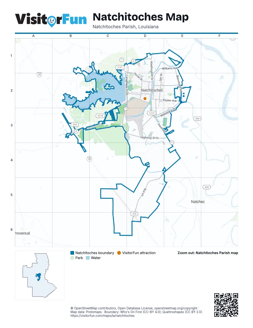
Street index of Natchitoches
Each street on the sheet and the grid squares it crosses.
- University ParkwayC2, D2, B3, C3
- Highway 3110D1, D2, C3, D3, E3
- South DriveD2, D3, E3
- Washington StreetD1, D2
- Highway 3175D1
- Jefferson StreetD2
- Rapides DriveD3
- Mill StreetD2, D3
- Rue FrontD2
- Williams AvenueD1, E1, D2
- LA 478D4, D5
- Texas StreetC1, D1, D2
- Keyser AvenueD2, E2
- State Route 478D5, D6
- State Route 504B1, B2, B3
- Rue ThirdD2
- Highway 3278C3
- Rue ChurchD2
- State Route 3191C1
- Church StreetD2
- State Route 494D2
- East 5th StreetD1, D2
- Parkway DriveE2, D3, E3
- Saint Maurice LaneD2, E2
- Fairgrounds RoadD3
- Blanchard RoadE1, E2
- Amulet StreetD2
- Martin Luther King Jr DriveD2
- Lake StreetD2
- Eight Mile LoopB3
- Old River RoadD3, D4
- Woodyard DriveD3, E3
- Dixie StreetD1, D2
- Whitfield DriveD2, E2
- South Jefferson StreetD2, D3
- Rue SecondD2
- Royal StreetD2, E2
- 5th StreetD2
- Tarlton DriveD2, D3
- Caspari StreetD2, D3
- Sam Sibley DriveD2
- Melrose AvenueD2, E2
- Rue PavieD2
- Watson DriveD2, D3, E3
- Flora Natchez RoadD5, D6
- 4th StreetD2
- 6th StreetD2
- Hancock AvenueD3, E3
- East 3rd StreetD2
- Dean StreetD2
- Saint Clair AvenueD2, E2
- Rue LafayetteD2
- Welch StreetD1, D2
- Rockford Church RoadD4
- Central AvenueD2, D3
- Henry AvenueD2
- Scarborough AvenueD2, E2
- School DriveD2, E2
- Demon DriveD2
- Trudeau StreetD2
- Airport RoadD3
- Sabine StreetD1, D2
- Howell StreetD2
- Berry AvenueD2
- Oakland DriveD2, E2
- North 5th StreetD1, D2
- PeninsulaC2
- South Williams AvenueD2, D3
- West Lakeshore DriveD1, D2
- Lakeview DriveE3
- Old Robeline RoadD2
- Chinquapin PlaceE2
- East 4th StreetD2
- Rowena StreetD2
- Abbie DriveE3
- Breazeale Springs StreetD1
- Hill AvenueD2
- Dorothy StreetD2
- Highland Park DriveD2
- North StreetD2
- West Court DriveD1
- Culbertson LaneD2, E2
- Clarence DriveE3
- Breda AvenueD1, D2
- Stephens AvenueD2
- Virginia AvenueD1, D2
- Holmes StreetD1, D2
- Grace AvenueD2
- Rue Saint-DenisD2
- Grayson StreetD2
- Stella StreetD1
- Martin DriveE2
- Touline StreetD2
- East 2nd StreetD2
- North Melrose AvenueE2
- Anita StreetD2
- Parish RoadC2, D2, E3, D4
- East 6th StreetD2, E2
- Edwina DriveD3
- St Clair AvenueE2
- Thomas StreetD2
- Sirod StreetD2
- Lime Kiln RoadC3
- Adelaide StreetD2
- Bienville StreetD2
- Winnona StreetD2
- Ledet DriveE2
- Carver AvenueD2
- Kingston DriveD3
- Nolley RoadC1, C2
- Sanford StreetD2
- Melissa PlaceD1
- High StreetD2
- Rue de GabrielD3
- Powell StreetD2
- Hazel StreetD3
- Arthur StreetD3
- Lakeshore Drive EastD1
- Northern StreetD1
- Bossier StreetD2
- Demeziere StreetD2
- Sylvan DriveD3
- Bivens StreetD1
- Claudia StreetE2
- Flora StreetD1
- J C Deblieux DriveD1
- Gold StreetD1
- Kaffie DriveD2
- East 7th StreetD2, D3
- Theophile AlleyD1
- Jean Marie StreetD2
- Payne StreetD2
- Garland RoadD3, E3
- Prather StreetD2
- Harling LaneD2
- Hedges StreetD2
- Nettie StreetD2
- Shoreline DriveD3
- Ouida DriveE3
- Masonic DriveE2
- Myrtle DriveD2
- Caldwell DriveD2
- Gibson StreetD2
- Front StreetD2
- Julia StreetD2
- Miranda LoopD3
- Bird AvenueD2
- Brahma DriveD2
- Rue SibleyD2
- Levy StreetD2
- Lebleu StreetD3
- Sorgee RoadC1
- Saint John StreetD1
- Renee StreetE2
- Ralph StreetE2
- Raphiel StreetD1
- Barclay DriveD1
- Desoto RoadD1
- Jackson DriveE3
- Arrington AvenueD3
- Robson StreetD1
- Phillips StreetD2
- TJoe StreetD3
- West StreetD2
- David StreetD3
- Maria LaneD3
- Tammye LaneE2
- Isadore DriveD2
- Salter StreetD1
- Hampton StreetD3
- Payne AvenueD1
- Organization DriveD3
- Settles Boat Landing RoadC2
- Salim StreetD2
- Bienville CircleD2
- Lower 5th StreetD2
- Moss Hill Terrace RoadC3
- Keegan DriveD2
- Maryland RoadD1
- Duplex StreetD2
- Cane River ParkwayD1
- Meadows DriveD2
- Posey StreetD2
- Cypress AvenueD2
- Reba StreetD3
- Tahoe AvenueD2
- July StreetD2
- Paula LaneE2
- College AvenueD2
- Allen StreetD2
- Castleton StreetD3
- Emanuel StreetD1
- Live Oak CircleD1
- Esther StreetD2
- La Chaisse StreetD1
- Gene LaneD3
- Glass StreetD3
- Dixie PlazaD2
- Elizabeth StreetD2, E2
- Howard StreetD2, E2
- Pegasus StreetD3
- Powhatan AlleyD2
- Poete StreetD2
- McClelland DriveD1, E1
- Kelly StreetD3
- Adams AvenueE1
- Hope StreetD2
- Edna AvenueE1
- Koonce StreetD2
- Robbins DriveD1
- Greenville StreetD1, D2
- Loren AvenueD2
- River Bend DriveE2
- Pine StreetD2
- Ash StreetD2
- University DriveD3
- Ponderosa RoadB1, B2
- Marion StreetD3
- Chinquapin CircleE2
- Genti StreetD3
- Amanda StreetD2
- Beverly RiseD1
- Joy StreetD1
- Oma StreetD2
- Railroad StreetD3
- Collins StreetD2
- Merilyn AvenueE2
- Anna StreetD3
- Sabine AlleyD2
- Pierson StreetD2
- Primrose StreetD2
- Baurd StreetD2
- Roy DriveD1, D2
- Katelyn CircleE2
- Wallenberg DriveD3
- Magnolia AvenueD3
- Scarborough CourtD2
- Georgia Ann StreetD1
- Sarah StreetE1
- Bayou Country RoadD5
- Brewton StreetE3
- Starlight DriveD2, E2
- Boyd StreetD2
- Rosebud StreetD2
- East Bienville StreetD2
- Spring StreetD1
- Pearl StreetD2
- Harry DriveD3
- Jackson StreetE2
- Teresa StreetD3
- Bonnette StreetD1
- Graham RoadD1, D2
- Sidney StreetD2
- Behan StreetD2
- Sawyer StreetD1
- 7th StreetD2
- Hidi DriveE2
- Greek Road Hill RoadD2
- Rikard LaneE2
- Wayne DriveD2
- Lauryn StreetD1
- South Court DriveD1
- Daniel StreetD3
- Jordan StreetD2
- Village CourtE2
- Ragan StreetD2
- Keegan AvenueD2
- George StreetE2
- Nelken StreetD2
- Fern StreetD2
- Mayfield StreetD2
- Morgan LaneE2
- Alice StreetD1, E1
- Mandell StreetD1
- Suzanne LaneD1
- Ben DriveD2
- Waters RoadC1
- East FifthD2
- Alaska StreetD2
- Rue HorneD2
- Robert CircleD1
- Percy StreetD2
- Fish Hatchery DriveD3
- Sewanne StreetD2
- Ellis StreetD2
- Piermont PlaceD3
- Bayou Jacko StreetD2
- Carver AlleyD2
- Depot StreetD2
- Lou StreetD2
- Pauline StreetD1
- Rusbo StreetD2
- Circle DriveD1
- McDodson WayD3
- East DriveE2
- Jeansonne StreetD2
- Simmons AlleyD2
- Beau Fort BoulevardE2
- Des Negis StreetD1
- Sibley Lake DriveC1
Things to do on the Natchitoches map
Places on the map
- Aaron's
- Agape Love Center
- All Hours Fitness
- Almost Home
- American Cemetery
- AutoZone
- Baptist Collegiate Ministry (BCM)
- Basic Health & Fitness
- Bedazzled Hair Salon
- Best Western Natchitoches Inn
- Breda Lake
- Brown-Stroud Baseball Field
- Burger King
- Cane River Brewing Company
- Catholic Cemetery
- Cato Fashion
- Chaplin Lake
- chevron
- Chick-fil-A
- Church of the Lord Jesus Christ
- Church Street Inn
- City Bank and Trust
- Dixie Plaza Shopping Center
- East Natchitoches Recreation Complex
- Fern Park Cemetery
- Genealogy Library
- Harry "Rags" Turpin Stadium
- L. P. Vaughn Elementary School
- Natchitoches Central High School
- Natchitoches Events Center
- Natchitoches Magnet School
- Natchitoches National Fish Hatchery
- Natchitoches Regional Airport
- Northwestern Hills Golf Course
- Northwestern State University
- Parc Natchitoches
- Saint Mary's School
- Sibley Lake
- Walmart Plaza
- Walmart Supercenter
Next to Natchitoches
- Natchez
- Provencal
© OpenStreetMap contributors, Open Database License, openstreetmap.org/copyright · Map data: Protomaps · Boundary: Who's On First (CC-BY 4.0); Quattroshapes (CC BY 2.0)















