

Louisiana map
Opelousas map
About 15,176 people live here (Census Bureau, 2024 estimate). The sheet's index lists 300 streets; Charles I. "Doc" Hudson Highway, I- 49 South Service Road and I-49 North Service Road cross the most grid squares. Also on it: Compass Behavioral Center of Opelousas, Oceans Behavioral Hospital Of Opelousas and South Park.
Open the map (PDF, US Letter)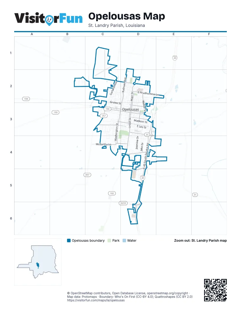
Street index of Opelousas
Each street on the sheet and the grid squares it crosses.
- Charles I. "Doc" Hudson HighwayE2, D3, D4, D5, D6
- South Union StreetD3, D4
- West Landry StreetC3, D3
- West Vine StreetC3, D3
- East Jefferson StreetD3
- East Vine StreetD3
- East Landry StreetD3
- South Main StreetD3
- North Main StreetD2, D3
- North Union StreetD2, D3
- Main StreetD2
- Church StreetD2
- Creswell LaneD3, D4
- South Bullard StreetC3
- State Highway 3233D6
- Harry Guilbeau RoadD6
- State Route 357C3
- State Route 104C3
- I- 49 South Service RoadE2, D3, D4, D5, D6
- I-49 North Service RoadD3, D4, D5, D6
- North Railroad AvenueD2, D3
- East Prudhomme LaneD2, E2
- Judson Walsh DriveD4, D5
- Park AvenueC3, D3
- Grandnigo RoadC2
- South Washington StreetC3, C4
- McCarthy LaneC4
- East Laurent StreetD3
- South Railroad AvenueC3, D3
- Heather DriveD4
- Wallior StreetD2, D3
- West Martin Luther King Jr DriveC2, D2
- East Grolee StreetD3
- Parkview DriveC3, C4
- South Academy StreetD3
- West Jefferson StreetC3, D3
- West Dunbar AvenueC4, D4
- East Dunbar AvenueD4
- East Martin Luther King Jr DriveD2
- Country Ridge RoadD4
- La 749C2
- South Market StreetD3, D4
- West Grolee StreetC2, C3, D3
- Jake DriveD3, D4
- Garland AvenueC2, C3
- East South StreetD3
- South Court StreetD3, D4
- West South StreetC3, D3
- West Bellevue StreetC3, D3
- Ducharme RoadD4, D5
- West Cherry StreetC3, D3
- Oak Leaf BoulevardD4, E4
- East Madison StreetD3
- George DriveD3, D4
- Perry LaneD2
- Natchez BoulevardD2
- Jasmine DriveD3, D4
- Fern StreetC3
- South Oak StreetD3
- Rice LaneC2, C3
- North Court StreetD2, D3
- North Market StreetD2, D3
- East Leo StreetD3
- Burr StreetC3
- East Bellevue StreetD3
- Powers StreetB2, C2
- Statesman RoadC2
- East North StreetD3
- Abdalla BoulevardD3, D4
- Rodney Milburn BoulevardD2
- North Walnut StreetD2, D3
- Linwood LoopD4, E4
- West Bertheaud AvenueC3, D3
- Redmond StreetD2
- Mary Ann StreetD3
- Broussard DriveD2
- Cherokee DriveD2
- South Walnut StreetD3
- East StreetD3
- Ballard LaneD3
- South Cane StreetD3
- Chickasaw DriveD2
- Ledoux CircleC2
- South Lombard StreetD3
- Larcade StreetC2, D2
- Lazaro BoulevardD6
- Evergreen LaneD3
- Raymond StreetC2
- Choctaw DriveD2
- South Liberty StreetD3
- Market StreetD2
- Plaisance StreetD2
- Julia StreetC3
- DuttonB2
- East Overton StreetD3
- Edwards StreetC4, D4
- Lakeview DriveD4, E4
- Arkansas AvenueC3
- Colorado AvenueC3
- Crouchet StreetC2
- Planter StreetC2, D2
- East Cheney StreetD2, D3
- Lastrapes StreetC2
- Patsy StreetC2, D2
- Attakapas DriveD2
- West Linwood DriveD5
- Frilot StreetC3
- Ina Clare DriveC3
- Ventre BoulevardD6
- East Leonard AvenueD3
- Melancon StreetD3
- East Sandoz StreetD2
- Commerce BoulevardD3
- Westwego StreetD2
- Madeline StreetD3
- Truman StreetD3
- East Franklin StreetD3
- West Church StreetD2
- Hayward StreetC3
- North Lombard StreetD2, D3
- West North StreetD3
- Congress StreetD2
- William CircleD6
- Airport TerraceC1
- West Bloch StreetD2
- Brown StreetC3, C4
- West Coleman StreetD2
- West Lincoln StreetD2
- Pamella StreetD3
- Dustin MorganD4
- Edith StreetD3
- Guidry StreetC2, D2
- Stardust StreetD3
- Hiram StreetC3
- Robin LaneD6
- Hall StreetC3
- Augustus StreetC3
- HuntingtonB2
- Vige StreetC4
- Pulford StreetC2, D2
- Vidrine StreetC2
- Woodlawn StreetC4
- Halpen StreetC3
- Walnut DriveD5
- Caddo StreetD2
- East Emmett StreetD2
- LakewoodD4
- Mouton StreetC3
- College AvenueC3
- West Blanchard StreetC3
- Pujo AvenueC3
- Tensas DriveD2
- Duson AvenueC3
- Park CircleC3
- North Cane StreetD3
- Hickory DriveD5
- Ernestine DriveD4, E4
- Karma C Schad DriveD5
- Wilson DriveD4
- AshwoodD5
- Joseph StreetC2, D2
- Herman StreetC2, D2
- North Oak StreetD2, D3
- Candy StreetC4
- Lawrence StreetD4
- Kim DriveC2, D2
- Rose Ann StreetC2
- West Tennis StreetC3, D3
- Adams StreetC2
- Blanchard StreetD3
- Sapphire StreetC2
- South King StreetD3
- Helen StreetD4
- Narrow StreetC3
- Harper StreetD2
- Prescott StreetD4
- Oak StreetD2, D3
- Pine AvenueD2
- Saint Cyr AvenueD3
- Sidney StreetC2, D2
- Montreal StreetD2
- Delmas StreetD4
- John AvenueD4
- Emmett StreetD2
- Lombard StreetD2
- Celeste StreetC3
- West Leonard StreetD3
- Pike AvenueD3
- Boisdore StreetC2
- Diesi StreetD4
- Beverly BoulevardD3
- Louisiana AvenueC3
- Veazie AvenueC3
- Wartell AvenueC3
- Mary AvenueD4
- McNeese StreetD2
- Simoneaux LaneC4
- Davis StreetD4
- Hattisburg StreetD2
- Tunica DriveD2
- Willow StreetD3
- West Convent StreetD2
- West Eliza StreetD2
- Leblanc StreetD2
- Hemlock DriveD4
- Abe Lincoln StreetC3
- Burr LaneC3
- Colliard StreetC2
- Ross StreetC3, C4
- Ware StreetC3, C4
- Henry StreetC2
- West White AvenueD4
- Brightside StreetC2
- East Bertheaud AvenueD3
- Shute StreetD2
- Common StreetD2
- Daly StreetD3
- Paris StreetD2
- Sandpiper LaneD4
- North Academy StreetD3
- East Tennis StreetD3
- Hospital DriveD2
- Laurel DriveC3
- East Pecan AvenueD4, E4
- East Smiley StreetD4
- Terry StreetD4
- Starling LaneD4
- Bernice StreetC3
- Goodloe StreetC3
- Anthony AvenueD4
- James Paul AvenueD4
- Highland DriveD3
- Eddins AvenueD4
- Rose AvenueD4
- Nicole LaneD2
- North Bullard AvenueC2, C3
- Vincent StreetD3
- Freedom DriveD2
- Lourdes StreetD3
- Leday StreetD2
- North Liberty StreetD3
- Woodhaven DriveD4, D5
- Meadowlark LaneD3
- West Andrus AvenueD4
- Blue StreetD2
- Taft StreetC3
- Mamie StreetD2
- East Andrus AvenueD4
- Stelly StreetC3
- Nash DriveD3
- Alonzo StreetC4
- Boagni StreetD2
- Lemoine StreetC2
- Chippewa DriveD2
- Lewis StreetC3
- Perrault StreetD3
- Hollier StreetD3
- West Prudhomme StreetD2
- Phillip StreetC3
- Larry StreetD3
- Berdie StreetC3
- Robert StreetC3
- Wayne StreetC3
- Cinnamon LaneD4
- Court YardD4
- Willard LaneC4
- Aaron Kimble AvenueC3
- Desoto StreetC2
- Laurel StreetC3
- Dietlien BoulevardD2
- Pandora StreetD2
- Aspen AvenueD4
- Hale StreetD3, D4
- Iris DriveC3
- Roberie DriveD3
- Houston StreetD3
- Cummings StreetC4
- Southwood DriveD4
- Hashim DriveD4
- Joyce DriveD3
- Anna Lee StreetC4
- Maple StreetD3
- Villere StreetD2
- Martel LaneD3
- Roland LaneC4
- John Jacob StreetD3, D4
- Williams StreetC3
- Newman StreetC2
- Piper DriveC4
- East White AvenueD4
- Bryan StreetC4
- East Bloch StreetD2
- East Foullard StreetD3
- East Littell StreetD3
- Holly DriveD3, D4
- East Cherry StreetD3
- Freeman StreetC3
- Gerry StreetD2
- Mayer StreetD2
- GalleryD4
Places on the map
- Acadiana Practitioners, LLC
- Advance Auto Parts
- American Bank
- AutoZone
- Billy's Boudin & Cracklin
- Breen Cafe
- Chevron
- Circle K
- Compass Behavioral Center of Opelousas
- Dixie Storage
- Don's Car Care & Tire Center
- Exxon
- Family Dollar
- Goodwill
- Holiday Inn & Suites Opelousas
- Holy Ghost Catholic Church
- Hospital Drive
- Little Zion Baptist Church
- Murphy USA
- Myrtle Grove Cemetery - Opelousas
- North Park
- O'Reilly Auto Parts
- Oceans Behavioral Hospital Of Opelousas
- OGHS - Building H
- OGHS - Building J
- OGHS - Building K
- Opelousas City Hall
- Opelousas General Health System
- Opelousas General Health System South Campus
- Opelousas Historic District
- Opelousas Museum And Interpretive center
- Opelousas Pentecostal Church
- Opelousas Public Library
- Our Lady Queen of Angels Catholic Church
- Saint Landry Catholic Church
- Saint Landry Cemetery
- Saint Landry Parish Airport
- South Park
- St. Landry Extended Care Hospital
- Walmart Supercenter
© OpenStreetMap contributors, Open Database License, openstreetmap.org/copyright · Map data: Protomaps · Boundary: Who's On First (CC-BY 4.0); Quattroshapes (CC BY 2.0)















