

Louisiana map
Youngsville map
About 19,038 people live here (Census Bureau, 2024 estimate). The sheet's index lists 300 streets; Chemin Metaire Parkway, Bonin Road and South Larriviere Road cross the most grid squares. Also on it: Southside High School, Youngsville Sports Complex and Highland Ridge Pond 1.
Open the map (PDF, US Letter)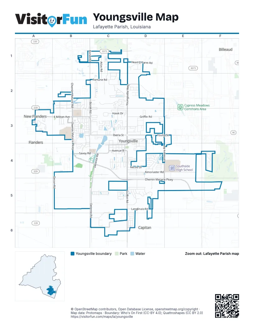
Street index of Youngsville
Each street on the sheet and the grid squares it crosses.
- Serenity DriveB1, C1
- Acres DriveC1
- Ambassador Caffery ParkwayC1
- Atlas RoadC1, C2
- Bonin RoadC1, C2, B3, C3
- Brahman DriveC1, C2
- East Angus DriveC1
- Holstien LaneC1, C2
- Hundred Oaks DriveC1, C2
- La Villa CircleC1
- Rousseau RoadC1
- Summertyme DriveC1
- West Angus DriveC1
- Heart D Farm RoadD1
- Melissa DriveD1
- Youngsville HighwayD1, D2, D3
- Anslem DriveB2
- Ashford LaneB2
- Chemin Metaire RoadB2, B3
- Crest Hill DriveB2, B3
- Crestmont BoulevardB2, B3, C3
- Fallen Oak LaneB2, B3
- Fieldcrest ParkwayB2, B3
- Gaslight LaneB2
- Green Cay LaneB2
- Kirkwood LaneB2
- La Rue BasB2, B3
- Laurel Grove BoulevardB2
- Long Cay DriveB2, B3
- Meadow Glen DriveB2
- Mill Pond DriveB2, B3
- Parker LaneB2, B3
- Pettigrove DriveB2
- Piper Crest LaneB2
- Pleasant Lake DriveB2
- Rue Des BouvierB2
- Rue Saint BartsB2
- Saint Blaise LaneB2
- South Saint Blaise LaneB2, B3
- Sugar Ridge LaneB2, B3
- Wild Rose LaneB2
- Arrowwood RoadC2
- Bayou Lake RoadC2
- Bayou Parc DriveC2
- Bluegrass Creek RoadC2
- Carmelite CircleC2
- Citron DriveC2
- Claystone RoadC2
- Copperfield WayC2, D2
- Country Hill BoulevardC2
- Country Park DriveC2
- Crest CircleC2, C3
- Cricklade CourtC2
- Doncaster CircleC2
- Emerson RoadC2
- Fortune RoadC2, D2
- Gravenhage CircleC2
- Greenwich PlaceC2
- Guernsey LaneC2
- Jersey DriveC2
- Krieg RoadC2
- Long Oak LaneC2
- Meadow Cove DriveC2, D2
- North Rushmore LaneC2, C3
- Pegasus BoulevardC2
- Perdu Hill RunC2
- Perdu Turn LaneC2
- Picadilly RoadC2
- Queensford WayC2
- Rock Lake RoadC2
- Saphire Springs RoadC2
- South Fork DriveC2
- Wallingsford CircleC2
- Woodhaven RoadC2
- Woodstock DriveC2
- Cascade Palm CourtD2
- Coco Palm CourtD2
- Sabal Palms RowD2
- Sago Palm WayD2
- Sunset Palm CourtD2
- West Fairfield DriveD2
- Beaufort CircleA3
- East Milton AvenueA3, B3
- Grand Lake DriveA3
- Grand Manor DriveA3
- Grand View DriveA3
- Heron BoulevardA3
- Lakeshore DriveA3
- Lighthouse Point CircleA3
- Southlake CircleA3
- Verot School RoadA3
- Windermere CircleA3
- Annaberg DriveB3
- Barbados Dr.B3
- Barton TerraceB3
- Bella Vista ParkwayB3
- Brookdale BoulevardB3
- Broyles StreetB3
- Brundage LaneB3
- Catalina LaneB3
- Catamaran DriveB3
- Cedar Grove DriveB3
- Cedar Hills DriveB3
- Centre Sarcelle BoulevardB3
- Charter CourtB3
- Chemin Metaire ParkwayB3, B4, C4, C5, D5
- Cordelia LaneB3
- Deysbrook LaneB3
- Drop Off LaneB3
- Gaunt LaneB3
- Greenbank LaneB3
- Harbor RoadB3
- Harvey Cay LaneB3
- Lake Crest LaneB3
- Lindbergh DriveB3
- Minolta RoadB3
- Montego Bay Dr.B3
- Palfrey ParkwayB3, C3
- Pick-up QueueB3
- Prescott BoulevardB3, C3
- Red Cedar LaneB3
- San Juan Ln.B3
- Shore DriveB3
- Stonehurst DriveB3
- Tortola LaneB3
- Waterview RoadB3
- Alciatore CourtC3
- Ben B StreetC3, D3
- Brook Field DriveC3
- Brook Hill DriveC3
- Brookhaven DriveC3
- Brookhollow DriveC3
- Burke StreetC3
- Cane Derrick DriveC3
- Cane Field DriveC3
- Cane Wagon CircleC3
- Cane Wagon DriveC3
- Captain Rick DriveC3
- Catskill LaneC3
- Copper Creek DriveC3
- Copper Hill DriveC3
- Copper Meadows BoulevardC3, D3
- Copper Ridge DriveC3
- Cornish PlaceC3
- Devon WayC3
- East Parkwood DriveC3
- Fountain View DriveC3
- Fox Creek DriveC3
- Green Springs RoadC3
- Hampshire StreetC3
- Hawk DriveC3, D3
- Iberia StreetC3, D3
- Jacques StreetC3, C4
- Julenie WayC3, C4
- Madison Wood CircleC3, C4
- Maxie Duhon RoadC3
- Meadow Lake DriveC3
- Oakthorn CourtC3
- Piedmont LaneC3
- Premier RoadC3, D3
- Preservation DriveC3
- Quiet Meadows DriveC3
- Quiet Oaks DriveC3
- Randy RoadC3
- Robdale DriveC3
- Rushmore LaneC3
- Saddleback CircleC3
- Scarborough DriveC3
- School StreetC3, C4
- Silver Cedar CourtC3
- South Parkwood DriveC3, C4
- Springview DriveC3
- Sweetwater CreekC3
- Vermilion CircleC3
- Beacon DriveD3, D4
- Bizkit DriveD3
- C'Est Bon CircleD3
- Calm DriveD3
- Chalant DriveD3
- Dartmouth CircleD3
- Dula StreetD3
- Elise DriveD3
- Griffin RoadD3
- Heritage DriveD3, E3
- Lafayette StreetD3, D4
- Legacy LaneD3
- Megans Way DriveD3
- Metals DriveD3
- Raoul StreetD3
- Romero StreetD3
- Seneca CircleD3
- Thorn DriveD3, D4
- Trenton DriveD3, D4
- Young StreetD3, E3
- North Larriviere RoadE3
- South Larriviere RoadE3, D4, E4, D5
- Chemin Metaire Parkway / Savoy RoadB4
- Savoy RoadB4, C4
- 1st StreetC4
- 2nd StreetC4
- 3rd StreetC4
- 4th StreetC4
- 5th StreetC4
- Avenue AC4
- Avenue BC4, D4
- Bennington LaneC4
- Breck AvenueC4, D4
- Cabot CourtC4
- Church StreetC4, D4
- Detente RoadC4, C5, C6
- Eugene StreetC4
- Harton RoadC4
- Oak Shadows DriveC4
- Railroad StreetC4
- Spring Oak DriveC4
- Almonaster RoadD4, E4
- Briarcliff DriveD4
- Brutus DriveD4
- Chapel Hill RoadD4
- Clay Ridge DriveD4
- Durel DriveD4
- Dusty Canyon DriveD4
- Equine CircleD4
- Flanders Ridge DriveD4
- Fox Hill RoadD4
- Green Mountain Ridge StreetD4
- Green Ridge DriveD4
- Guillot RoadD4, C5, D5, D6
- Hidden Hills DriveD4
- Hill Ridge DriveD4, E4
- Katy Beth DriveD4
- Lahasky DriveD4
- Maureen DriveD4
- Nicole DriveD4
- Oak Hill LaneD4
- Old Farm RoadD4
- Peak RunD4
- Pheasant DriveD4
- Quiet Bluff DriveD4
- Revere DriveD4
- Shadowbrook LaneD4
- Squirrel RunD4
- Summit Crest DriveD4
- Tall Oaks LaneD4
- Timber Point DriveD4
- Winding WayD4
- Bus Drop OffE4
- Marteau RoadE4
- Zoe LaneE4
- Rue de la PaisF4
- Decon RoadB5
- Alder PlaceC5
- Amsterdam AvenueC5
- Bruges LaneC5
- Buenos Aires AvenueC5
- Burley RoadC5
- Canton CourtC5
- Cape Town AvenueC5
- Chemin Metairie ParkwayC5, D5
- Fallstone RoadC5
- Gilmore RoadC5
- Highland View DriveC5
- Kipling StreetC5
- Meadowhollow DriveC5
- Medar Mound LaneC5
- Prague AvenueC5
- Queenstown AvenueC5, D5
- Rolling Mill LaneC5
- Smithville CourtC5
- Zurich AvenueC5
- Berg CourtD5
- Caillou Grove RoadD5
- Cautillion DriveD5
- Chemet RoadD5
- Chemin Metarie ParkwayD5, E5
- Forest Grove DriveD5
- Hutton LaneD5
- Janson WayD5
- Langlinais RoadD5
- Langston CourtD5
- Marston House DriveD5
- Mintmere LaneD5
- New Snow CircleD5
- Nezpique RoadD5
- St. Lucius StreetD5, D6
- Tee Jill LaneD5
- Valcour PlaceD5
- Valesco CrossingD5
- Viaulet RoadF5
- Chemin Agreable RoadC6
- Chemin Agreable StreetC6, D6
- Vice LaneC6, D6
- Piat RoadD6
- St. Bruno StreetD6
- St. Caillin StreetD6
- St. Faith StreetD6
- St. Fazzio StreetD6
- St. Gall StreetD6
- St. Gaspar StreetD6
- St. Kenan StreetD6
Places on the map
- Acadiana Renaaissance Charter Academy
- Acadiana Renaissance Charter Academy
- Acadiana Renaissance Charter Academy High School
- Ackal's Community Pharmacy
- Anytime Fitness
- Bus Drop Off
- Centre Sarcelle Boulevard
- Chemin Metaire Parkway;Savoy Road
- Chevron
- Community First Bank
- Copperfield Estates/South & the Village pool
- CVS Pharmacy # 16
- Dollar General
- Domino's
- Ernest Gallet Elementary School
- Exxon
- Farmers State Bank & Trust Co
- Green T Lindon Elementary School
- Guillot Road
- Highland Ridge Pond 1
- Highland Ridge Pond 2
- Highland Ridge Pond 3
- Hook'd Up Bar and Grill
- Meche's Donut King
- Michael P. Maraist Memorial Field (Ascension Episcopal School)
- NuNu's Fresh Market
- O'Reilly Auto Parts
- Palfrey Park
- Rouses
- Saint Anne Catholic Church
- Southside High School
- Super 1 Foods
- United States Post Office
- Veterans Park
- Wells Landing Back Pond
- Wells Landing Front Pond
- Wells Landing Middle Pond
- Youngsville City Hall
- Youngsville Post Office
- Youngsville Sports Complex
Next to Youngsville
- Billeaud
- Capitan
- Flanders
- New Flanders
© OpenStreetMap contributors, Open Database License, openstreetmap.org/copyright · Map data: Protomaps · Boundary: Who's On First (CC-BY 4.0); Quattroshapes (CC BY 2.0)















