

Massachusetts map
Belchertown map
About 15,372 people live here (Census Bureau, 2024 estimate). The sheet's index lists 269 streets; Federal Street, Munsell Street and North Street cross the most grid squares. Also on it: Bondsville Water Supply Land, Cold Spring Country Club and Holland Glen Forest.
Open the map (PDF, US Letter)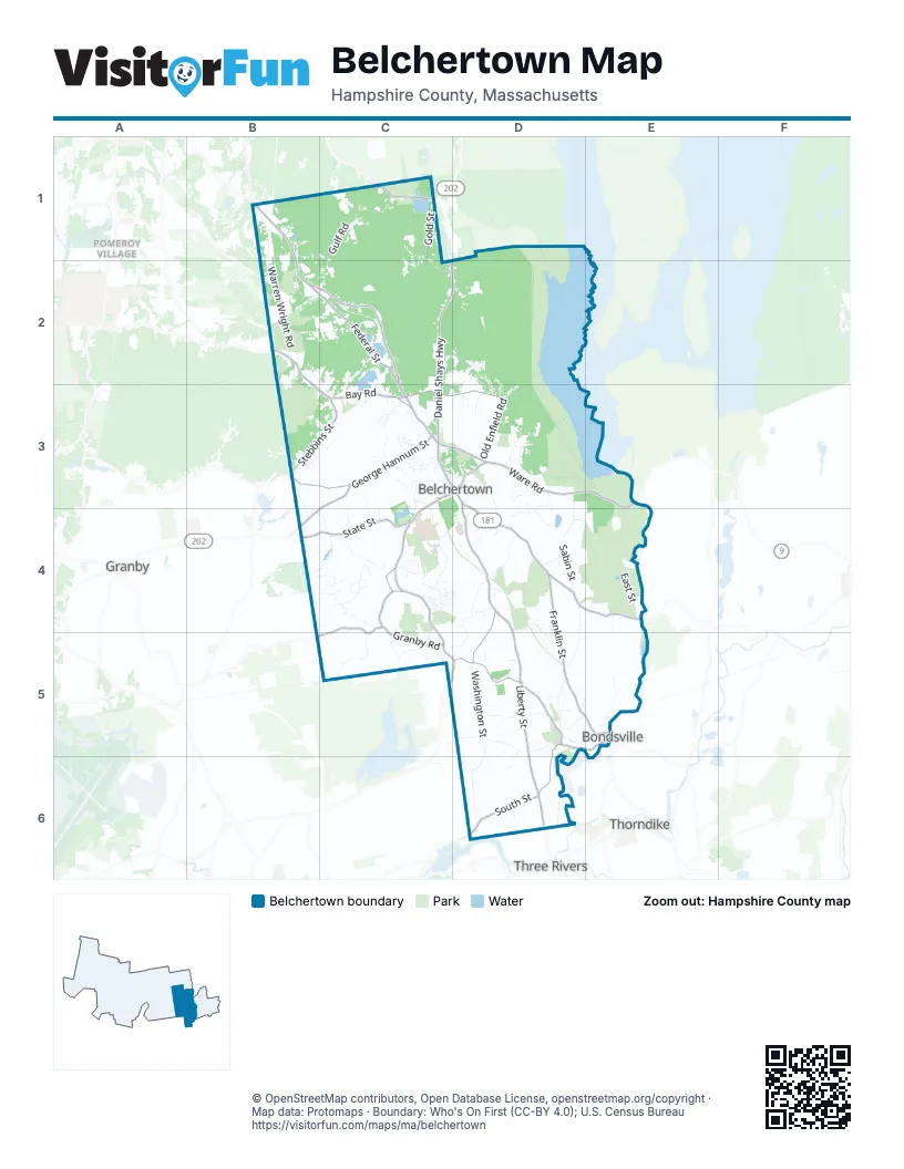
Street index of Belchertown
Each street on the sheet and the grid squares it crosses.
- Brenda LaneB1
- Concord WayB1
- Federal StreetB1, B2, C2, C3
- North StreetB1, C1, D6
- Old Amherst RoadB1
- Raymond DriveB1
- Two Ponds RoadB1
- USMC League HighwayB1
- Warren Wright RoadB1, B2
- Gold StreetC1
- Gulf RoadC1, B2, C2
- King StreetC1
- Knight StreetC1
- Munsell StreetC1, C2, D2, C3
- North Gulf RoadC1
- Packardville RoadC1, D1
- Primrose LaneC1
- South Gulf RoadC1
- Trillium WayC1
- Juckett Hill RoadD1, D2
- Old Ward RoadD1, D2
- Amherst RoadB2, C2
- Bay Path RoadB2
- Bay RoadB2, B3, C3
- Cemetery RoadB2
- Goodell StreetB2, C2
- Hulst RoadB2
- Lamson AvenueB2
- Old Bay RoadB2, C2, C3
- Orchard RoadB2, C2
- Wilson StreetB2
- Channel DriveC2
- Cheryl CircleC2
- Daniel Shays HighwayC2, D2, C3
- Diane DriveC2
- Grela TerraceC2
- Kopec AvenueC2, D2
- Lake DriveC2
- Lake Drive AccessC2
- Metacomet CircleC2
- Metacomet StreetC2, C3
- Oasis DriveC2
- Old Farm CircleC2
- Old Farm RoadC2
- Old Pelham RoadC2, C3
- Oliver StreetC2
- Pelham RoadC2, C3
- Plaza AvenueC2
- Poole RoadC2, C3
- Sheffield DriveC2, D2
- Town Beach RoadC2
- Brandywine DriveD2, D3
- Earley StreetD2, D3
- Fletcher AvenueD2, D3
- Jucket RoadD2, D3
- Kimball StreetD2
- Lexington DriveD2
- Old Enfield RoadD2, D3
- Spring Hill RoadD2
- Waterford DriveD2
- Batchelor StreetB3
- Clearbrook DriveB3
- Daniel SquareB3
- Daniel Square ExtensionB3
- Emily LaneB3, C3
- George Hannum StreetB3, C3
- Mercier DriveB3, C3
- Pinebrook DriveB3
- Rural StreetB3, B4
- Stebbins StreetB3, C3
- Administration RoadC3
- Allen StreetC3, D3
- Atherton LaneC3
- Berkshire AvenueC3, C4
- Boardman StreetC3, B4, C4
- Bridge StreetC3
- Brook HollowC3
- Cadwell LaneC3
- Carriage DriveC3
- Catherine DriveC3
- Center StreetC3
- Chadbourne RoadC3
- Chartier DriveC3
- Clark StreetC3
- Cobb LaneC3
- Cold Spring CommonC3
- Cottage StreetC3, D3
- Country LaneC3
- Dana HillC3
- Disposal Plant RoadC3
- Dogwood DriveC3
- Dump RoadC3
- Eagle HeightsC3
- East Walnut StreetC3, D3
- Front StreetC3
- Greenwich HillC3
- Hamilton StreetC3
- Hickory HillC3
- Howard StreetC3
- Howe StreetC3
- Jackson StreetC3
- Jon DriveC3, C4
- Jonquil EstatesC3
- Lloyd AvenueC3
- Magnolia LaneC3
- Main StreetC3, D3
- Maple StreetC3, D3
- Metacomet Access RoadC3
- Newton StreetC3
- North Main StreetC3
- Park StreetC3, D3
- Pit RoadC3
- Prescott HillC3
- Rita LaneC3
- Salvage Yard RoadC3
- Sarah LaneC3
- Sargent StreetC3, D3
- School RoadC3
- Stadler StreetC3, C4
- State StreetC3, B4, C4
- Sycamore CircleC3
- Tucker LaneC3
- Underwood StreetC3, C4
- Westview DriveC3
- Westwood DriveC3
- Whispering Pines AvenueC3
- Whitlock WayC3, C4
- Woodhaven DriveC3
- Blue Meadow RoadD3, E3
- Cold Spring RoadD3
- Cold Spring School RoadD3
- Deer RunD3
- Doe HollowD3
- Eastview DriveD3
- Edelcy DriveD3
- Everett AvenueD3
- Heritage DriveD3
- Jabish StreetD3
- Jason's WayD3, D4
- Jensen StreetD3
- Jenson StreetD3, D4
- Johnson RoadD3
- Meadow Pond RoadD3, D4
- Mill Valley RoadD3, D4
- North Washington StreetD3, D4, D5
- Old Sawmill RoadD3
- Pondview CircleD3
- Randall RoadD3
- Sabin StreetD3, D4
- Segur LaneD3
- Sherwood DriveD3
- South Main StreetD3
- Ware RoadD3, E3
- Warner StreetD3
- Willow LaneD3, D4
- Ballou StreetE3, E4
- Belchertown RoadE3
- East StreetE3, E4
- Enoch Sanford RoadE3, E4
- Power Station RoadE3
- Winsor Dam RoadE3
- Barton AvenueB4, C4
- Dressel AvenueB4
- Dressell AvenueB4
- Eskett StreetB4, C4
- Fred Ruel RoadB4
- Avenue AC4, D4
- Avenue BC4, D4
- Avenue CC4, D4
- Avenue DC4, D4
- Avenue EC4, D4
- Avenue FC4, D4
- Avenue GC4
- Avenue HC4
- Avenue JC4
- Avenue KC4
- Avenue LC4
- Avenue MC4
- Avenue NC4
- Azalea WayC4
- Chauncey Walker StreetC4, C5, D5
- Chestnut DriveC4
- Crestview DriveC4
- Forest RoadC4
- Granby RoadC4, C5
- Harrington WayC4
- Helen LaneC4
- Hemlock HollowC4
- Henry DriveC4
- Jeffrey LaneC4
- Jon Drive SouthC4
- Laurel Ridge DriveC4
- Lawrence RoadC4
- Ledgewood CircleC4
- Ledgewood DriveC4
- Ludlow StreetC4, C5
- Maplecrest DriveC4
- Meadow View DriveC4
- Mountain View DriveC4
- Oak Ridge DriveC4
- Oakridge DriveC4
- Overlook DriveC4
- Pendleton RoadC4
- Pepper Ridge DriveC4
- Pinewood RoadC4
- Plantation DriveC4
- Rockrimmon StreetC4, B5, C5
- Springfield RoadC4, D4
- Summit StreetC4
- Sunset AvenueC4
- Terry LaneC4
- Turkey Hill RoadC4
- Aldrich StreetD4
- Blossom LaneD4
- Bunker WayD4
- Canal DriveD4
- Cedar Glen DriveD4
- Cold Spring StreetD4, E4
- Cordner RoadD4
- First RoadD4
- Franklin StreetD4, D5, E5
- Fuller StreetD4
- Jabish Canal RoadD4, C5, D5
- Kennedy RoadD4, D5
- Martin CircleD4
- Michael Sears RoadD4, D5
- Moss LaneD4, D5
- Nathaniel WayD4
- North Liberty StreetD4, D5
- Pease LaneD4
- Rainbow DriveD4
- Random RoadD4
- RidgecrestD4
- Robin LaneD4
- Moore RoadE4, E5
- Green AvenueC5
- Pheasant RunC5
- Rimrock DriveC5
- Shaw StreetC5
- Alden AvenueD5, D6
- Autumn LaneD5
- Bardwell StreetD5
- Barrett StreetD5
- Blacksmith RoadD5
- Bondsville RoadD5
- Carol Ann DriveD5
- Clover Hill RoadD5
- Cloverhill RoadD5
- Eugene DriveD5
- Fox Run DriveD5
- High Bluff RoadD5
- Keith AvenueD5, E5
- Oakwood DriveD5
- Pease StreetD5
- Pine StreetD5, E5
- River StreetD5, E5
- South Liberty StreetD5, D6
- South StreetD5, D6
- South Washington StreetD5, D6
- Sunny Crest LaneD5, E5
- West StreetD5
- Woodland LaneD5
- Depot StreetE5
- Keyes StreetE5
- Shea AvenueE5
- Mills RoadD6
- Poole StreetD6
- Railroad StreetD6
- Sylvan CircleD6
Places on the map
- Amherst Water Supply Land
- Arcadia Bog
- Arcadia Bog Conservation Area
- Arcadia Lake
- Atkins
- Atkins Farms
- Austin Gaughan Memorial Field
- Belchertown High School
- Belchertown Landfill
- Belchertown Town Hall
- Bondsville Water Supply Land
- Chestnut Hill Community School
- Cold Spring Country Club
- Conservation Area
- Don Mader Town Forest
- Fairview Fish And Game Club
- Foley Field
- Holland Glen Forest
- Independence Stable
- Jabish Brook Conservation Area
- Jabish Street Pumping Station
- Knights Pond
- Meads Corner Conservation Area
- Metacomet Lake
- Mill Valley Golf Links
- Northeast Treaters
- Piper Farm
- Quabbin Reservoir Watershed
- Reed Property Conservation Restriction
- Springfield Water Supply Land
- Swift River Conservation Area
- Swift River Sportsmans Club
- The Meadows Conservation Area
- Topping Farm Conservation Area
- UMass Experimental Forest
- UMass Orchards
- Water Supply Area
- Water Supply Land
- Water Supply Prot. Dep/Ala
- Wenzel Agricultural Preservation Restriction
Next to Belchertown
- Bondsville
- Granby
- Pomeroy Village
- Thorndike
- Three Rivers
© OpenStreetMap contributors, Open Database License, openstreetmap.org/copyright · Map data: Protomaps · Boundary: Who's On First (CC-BY 4.0); U.S. Census Bureau















