

Massachusetts map
Easthampton map
About 16,020 people live here (Census Bureau, 2024 estimate). The sheet's index lists 300 streets; East Street, Mountain Road and Loudville Road cross the most grid squares. Also on it: Hannum Brook Conservation Area, Lower Millpond and Nashawannuck Pond.
Open the map (PDF, US Letter)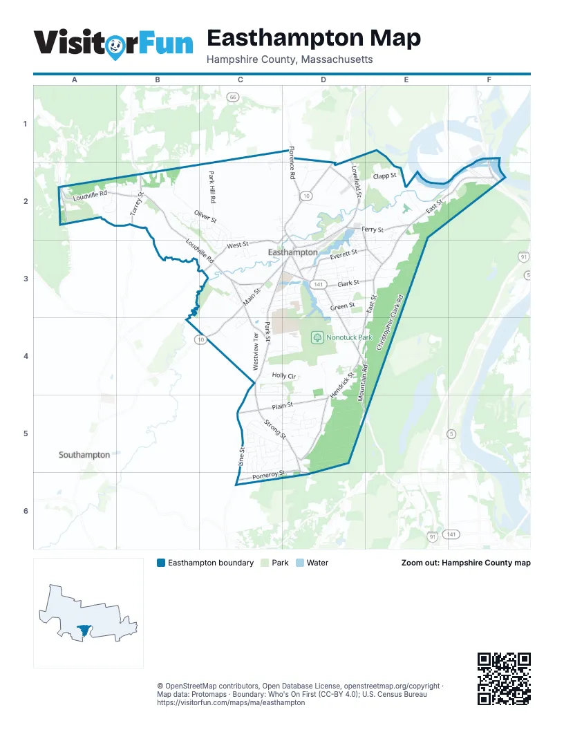
Street index of Easthampton
Each street on the sheet and the grid squares it crosses.
- Main StreetC3, D3, C4
- Northampton StreetD2, D3
- Holyoke StreetD3, D4
- Mountain RoadD4, E4, D5, E5
- Union StreetD3
- North StreetF1, F2
- Cottage StreetD3
- Easthampton RoadE5
- East StreetE2, F2, E3, D4, E4
- Loudville RoadA2, B2, B3, C3
- Park StreetC3, D3, C4
- Line StreetC4, C5, C6
- West StreetD2, C3
- Lovefield StreetD1, D2
- South StreetC3, C4
- Ferry StreetD2, E2
- Pleasant StreetD2, D3
- Florence RoadD1, D2
- Torrey StreetB2
- Oneill StreetD2
- Glendale StreetC3
- Glendale RoadB2
- Hendrick StreetD4, D5
- Strong StreetC4, C5, D5, D6
- Plain StreetC5, D5
- Pomeroy StreetD5, C6, D6
- Clark StreetD3, E3
- Everett StreetD3, E3
- Parsons StreetD2, E2, E3
- Mineral StreetA2
- Adams StreetD3
- Payson AvenueD3
- Liberty StreetD3
- Pomeroy Meadow RoadC3
- Wonderlich StreetD5
- Christopher Clark RoadE3, E4, E5
- Oliver StreetB2, C2, C3
- Bill Halford WayD3, D4
- Park Hill RoadC2
- Phelps StreetC5, D5
- Carillon CircleB2, C2
- Campbell DriveC5, D5, C6, D6
- Reservation RoadE3
- Ashley CircleA2, B2
- Fort Hill RoadE2
- Holly CircleC4, D4
- Westview TerraceC4
- Hannum Brook DriveC2, C3
- Maple StreetD3
- Clapp StreetD2, E2
- Briggs StreetD3
- Brook StreetD4, D5
- Lyman StreetD2
- Kingsberry WayC4, D5
- Pine Hill RoadA2, B2
- Clark LaneB2
- Williston AvenueD3
- Overlook DriveD5
- Division StreetC5, D5
- Bayberry DriveC4, D4
- Garfield AvenueC3, D3
- Sterling DriveC5, D5
- Morin DriveC5
- Hisgen AvenueD3
- Kenneth RoadC5
- Picard CircleC5
- Meadowbrook DriveC3
- Franklin StreetD3
- Ward AvenueC3, D3
- Highland AvenueD2
- Bassett Brook DriveC1, D1, C2
- Mount Tom AvenueD3
- Cherry StreetD3
- East Green StreetD3
- Sandra RoadD5
- Rabideau DriveC5
- Golden DriveC5, D5
- Emerald PlaceD2, D3
- Peloquin DriveC5, C6
- River StreetE2
- Lawler DriveC2, C3
- Treehouse CircleD4
- Knipfer AvenueD3
- Taft AvenueC3, D3
- Industrial ParkwayD2
- Richmond WayD4
- Ballard StreetD2
- Button RoadC4, D4
- Drury LaneA2
- Lazy D DriveE2, E3
- Bryan AvenueC3, D3
- Beyer DriveC5, C6
- Terrace ViewD2
- Water LaneD3
- Matthew DriveD5
- Monska DriveC5, C6
- Davis StreetD3
- Mutter StreetD3
- Dragon CircleC2, D2
- Deerfield DriveC2
- Gula DriveC5
- Pine Brook DriveC2, C3
- Stone Path LaneD3
- Broad StreetE3
- Kania StreetC5
- Kimberly LaneC5
- Burt StreetD5, D6
- Mechanic StreetD3
- Droy CircleC5
- Spring StreetD3
- Zabek DriveC5
- Laurin LaneB2, C2
- Vadnais StreetD4
- Evans AvenueC2
- John StreetC4
- Chapin StreetE3
- McKinley AvenueC3
- Duda DriveE3
- Groveland StreetC2, D2
- Coed DriveC5, D5
- Center StreetC3, D3
- Concord DriveC2, C3
- Pepin AvenueE2, E3
- Willow CircleD5
- Apple Tree LaneD5
- Laurel DriveC5, D5
- Oakdale PlaceD2
- Admiral StreetD3
- Pumping Station RoadD4
- Sheldon AvenueC3
- Greenwood CourtC3
- High StreetD3
- Fox RunD5
- Sheffield DriveD5
- Lawson DriveC5
- Stanley StreetD2
- Camelot LaneD5
- Melinda LaneD5
- Lyman AvenueD2, D3
- Knight AvenueC3
- Russell LaneB2
- Chapman AvenueD3
- Emily LaneD5
- Pine StreetD3
- Combs RoadE1, E2
- Mayher StreetD3
- Howard AvenueC2, C3
- Truehart DriveC4
- Plaza AvenueD4
- Lincoln StreetD2, D3
- River Valley WayD4
- Robin RoadC3
- Arthur StreetE2
- Denucce WayD4
- Laplante CircleC3
- Lussier CircleD4
- Keddy StreetD4
- First AvenueD3, E3
- Harvey StreetD4
- Silver LaneC5, D5
- Grant StreetD3
- Oak Ridge CircleC3
- Fairfield AvenueD3
- Underwood AvenueF2
- Jones DriveC5
- Summit AvenueD4
- Huckleberry LaneD1, D2
- Colonial AvenueD2
- Richardson CircleD4
- Chestnut StreetD3
- Orchard StreetD3
- Water StreetD3
- Church StreetD3
- East Maple StreetE3
- Gaston StreetD3
- Princeton AvenueE2
- Exeter StreetD2
- Grandview LaneD1, D2
- Grove StreetD3
- Plum Brook DriveE3
- Nashawannuck StreetD3
- West Green StreetD3
- Beechwood AvenueC3
- Steplar CrossingB2
- Wemelco WayC4
- Gaugh StreetD3
- Wright StreetC3
- Brewster AvenueC3
- Brittany LaneD4
- Lexington DriveB2
- West Park DriveC4
- Federal StreetD2
- Elizabeth LaneD3
- Louise AvenueC3
- Gross LaneE3
- Dartmouth StreetD2
- Mulberry LaneC2
- Winter StreetD3
- Summer StreetD3
- Karen CircleC4
- Cook RoadC6
- Crescent StreetC4
- Bay AvenueD3, D4
- Prospect StreetD3
- Third AvenueE3
- Ridgewood TerraceD2
- Harrison AvenueD2, D3
- Hudson StreetD3
- Clinton StreetD3
- Lownds AvenueD3
- Campus LaneD3
- Lux AvenueD3
- Carol AvenueC3
- Sunset AvenueC3, C4
- Doody AvenueD3
- Maxine CircleD2
- Gosselin DriveE2
- Ely AvenueC3
- Lord StreetC3, C4
- West Lake StreetD3
- Frederick Dickinson CourtD3
- Sutton PlaceE3
- Ranch AvenueC3
- Railroad StreetD3
- Riley StreetC4
- Maine AvenueD3, E3
- Mill StreetD2
- Clark AvenueD3
- Paul StreetC3
- Plymouth AvenueD2
- Chapel StreetD3
- Allen StreetD4
- Lukes WayE2, E3
- Elliot StreetD3
- Searls StreetC2, C3
- Wilton RoadC3
- Edward AvenueD2, E2
- East Chestnut StreetE3
- Hampton TerraceD2
- Old Springfield RoadE2
- School StreetD3
- Wilder AvenueF2
- Corner LaneA2
- Lawndale StreetC2, D2
- Arlington StreetD2
- Fleury CourtC3
- Tower LaneD4
- Berkeley StreetD2
- Teaberry LaneC1, C2
- Crown DriveB2
- Windsor CircleD5
- Boylston StreetD2, E2
- Loomis WayE2
- North Hampshire StreetD3
- Putnam CourtD3
- Wendell AvenueC2
- Olympia StreetD3
- Saint James AvenueC3
- Williams StreetC3, C4
- Charles StreetD3
- Susan DriveC5
- Old Stagecoach RoadE2
- Ian CircleE2
- Symanski AvenueF2
- Cranberry LaneC1
- Echo LaneD4
- Newell StreetC3
- Cedarwood AvenueC3
- Autumn DriveD5
- Pleasant Green EastD2
- Torrey WayB2
- Hunter LaneA2
- Hollister DriveB2
- Upland Meadow WayA2
- Culdaff StreetD3
- Norton StreetC3
- Birchwood DriveC4
- Dewey StreetC3
- Lovefield WayD2
- Bernie AvenueD5
- Lang AvenueD4
- Lovell StreetD3
- Crestview DriveD4, D5
- Hill AvenueD3
- Pleasant Green WestD2
- Raymond AvenueE3
- Conrad CircleB2
- Friel DriveC3
- Payson LaneC3
- Ranch LaneC3
- Spiceberry LaneC1
- Schumikowski StreetC5
- Laura AvenueD3
- Mountainview StreetD2
- South Hampshire StreetD3
- Wellington CircleD5
- Paradise DriveD3
- Irving StreetD3
- Lake StreetD3
- Johnson AvenueD3
Places on the map
- Bill Halford Way
- Boruchowski Parcel
- Broad Brook Meadows Conservation Area
- Brookside Cemetery
- Camp Cook
- Clapp Memorial Library
- Daley Field
- Easthampton City Hall
- Easthampton High School
- Easthampton Post Office
- Easthampton Public Library
- Echodale Farm
- Edward J. Dwyer Conservation Area
- Emily Williston Memorial Library
- Galbraith Fields
- Guistina Property
- Hannum Brook Conservation Area
- Hartnett-Manhan Memorial Forest
- Hendrick Street Wellfield
- Lovefield Wellfield
- Lower Mill Pond Park
- Lower Millpond
- Main Street Cemetery
- Manhan River Reservoir
- Mlct/Atmore & Droescher
- Mount Tom North Trailhead Park
- Nashawannuck Pond
- Nonotuck Park
- North Branch Conservation Area
- Oliver Street Land
- Palmer Paving Corporation
- Pomeroy Meadows Conservation Area
- Rubber Thread Pond
- Saint Brigids Cemetery
- Saint Stanilaus Cemetery
- Town Agricultural Land
- Town Forest
- Town Hall Backland
- Vlf/Sena
- Williston Northampton School
Next to Easthampton
- Southampton
© OpenStreetMap contributors, Open Database License, openstreetmap.org/copyright · Map data: Protomaps · Boundary: Who's On First (CC-BY 4.0); U.S. Census Bureau















