

Maryland map
Howard County map
About 339,668 people live here (Census Bureau, 2024 estimate). The sheet's index lists 55 streets; Frederick Road, Old Frederick Road and Columbia Pike cross the most grid squares. Things to do inside the boundary: Howard County Welcome Center and Toby's Dinner Theatre.
Open the map (PDF, US Letter)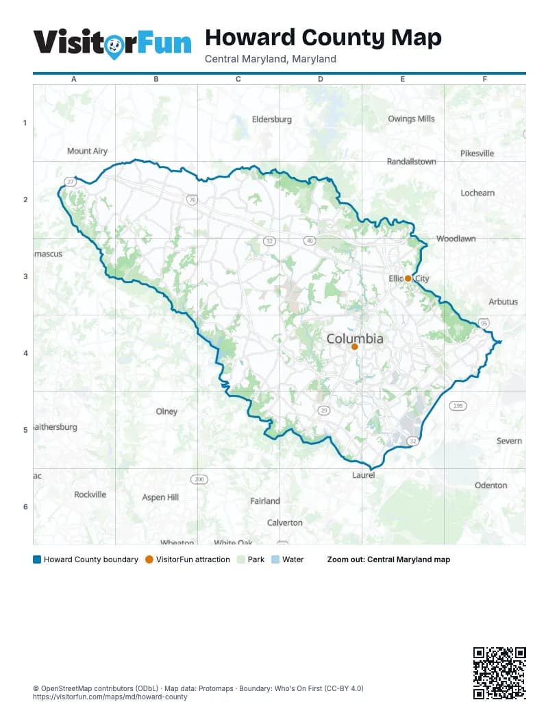
Street index of Howard County
Each street on the sheet and the grid squares it crosses.
- Frederick RoadA2, B2, C2, C3, D3, E3
- Long Corner RoadA2
- Penn Shop RoadA2
- Ridge RoadA2
- Lisbon North RoundaboutB2
- Lisbon South RoundaboutB2
- Woodbine RoadB2, A3, B3
- Baltimore National PikeC2, D2, D3, E3
- Hoods Mill RoadC2
- Old Frederick RoadC2, D2, E2, D3, E3
- Roxbury Mills RoadC2, B3, C3
- Sykesville RoadC2, C3, C4
- West Friendship RoadC2
- Marriottsville RoadD2, D3
- Old Court RoadD2
- Woodstock RoadD2
- Columbia PikeE2, E3, D4, E4, D5
- Rogers AvenueE2, E3
- Georgia AvenueB3
- Clarksville PikeD3, E3, C4, D4, C5
- Columbia RoadE3, D4, E4
- Court House DriveE3
- Ellicott Mills DriveE3
- Main StreetE3
- Montgomery RoadE3, E4
- Old Annapolis RoadE3, E4
- Saint Johns LaneE3
- Waterloo RoadE3, E4, E5
- Brighton Dam RoadC4
- Browns Bridge RoadC4, C5
- Guilford RoadC4, D4
- Hall Shop RoadC4, D4, C5
- Patuxent FreewayC4, D4, E4, E5
- Scaggsville RoadC4, D5
- Ten Oaks RoadC4
- Broken Land ParkwayD4, E4
- Cedar LaneD4
- Governor Warfield ParkwayD4
- Harpers Farm RoadD4
- Little Patuxent ParkwayD4
- Rouse ParkwayD4, E4
- Sanner RoadD4, D5
- Dorsey RoadE4, F4
- Dorsey Run RoadE4, F4, E5
- Meadowridge RoadE4
- Snowden River ParkwayE4
- Washington BoulevardE4, F4, E5
- Harbor Tunnel ThruwayF4
- Paul T. Pitcher Memorial HighwayF4
- Ashton RoadC5
- Lime Kiln RoadC5, D5
- Johns Hopkins RoadD5
- Maple Lawn BoulevardD5
- 2nd StreetE5
- Jessup RoadE5
Things to do on the Howard County map
Places on the map
- Abbeyfield Estates
- Allview Estates
- Alpha Ridge Community Park
- Alpha Ridge Landfill
- Amber Meadow
- Annandale
- Annetta Gardens
- Arrowhead
- Atholton High School
- Autumn Crest
- Autumn Overlook
- Autumn River
- Baltimore Washington Industrial Park
- Belmont Station
- Bethany Glen
- Bethany Manor
- Bethgate
- Bethwood
- Blandair Regional Park
- Braebrooke
- Brantly
- Briar Hill
- Briarcliffe
- Brightfield
- Brighton Farm Estates
- Brighton Pines
- Brinkleigh Manor
- Broadwater Estates
- Broken Land Business Center
- Buckskin Woods
- Burgess Mill Station
- Cameron Tract
- Canbury Woods
- Canterbury Riding
- Cattail Creek Country Club
- Cattail Overlook
- Cedar Creek
- Cedar Lane Park
- Cedar Place Apartments
- Centennial High School
Next to Howard County
- Arbutus
- Aspen Hill
- Calverton
- Colesville
- Damascus
- Eldersburg
- Fairland
- Gaithersburg
- Laurel
- Lochearn
- Montgomery Village
- Mount Airy
- North Bethesda
- Odenton
- Olney
- Owings Mills
- Pikesville
- Randallstown
- Redland
- Rockville
- Severn
- Wheaton
- White Oak
- Woodlawn
© OpenStreetMap contributors (ODbL) · Map data: Protomaps · Boundary: Who's On First (CC-BY 4.0)