

Maine map
Bangor map
About 32,446 people live here (Census Bureau, 2024 estimate). The sheet's index lists 300 streets; Broadway, Union Street and Ohio Street cross the most grid squares. Things to do inside the boundary: Cole Land Transportation Museum and Maine Discovery Museum.
Open the map (PDF, US Letter)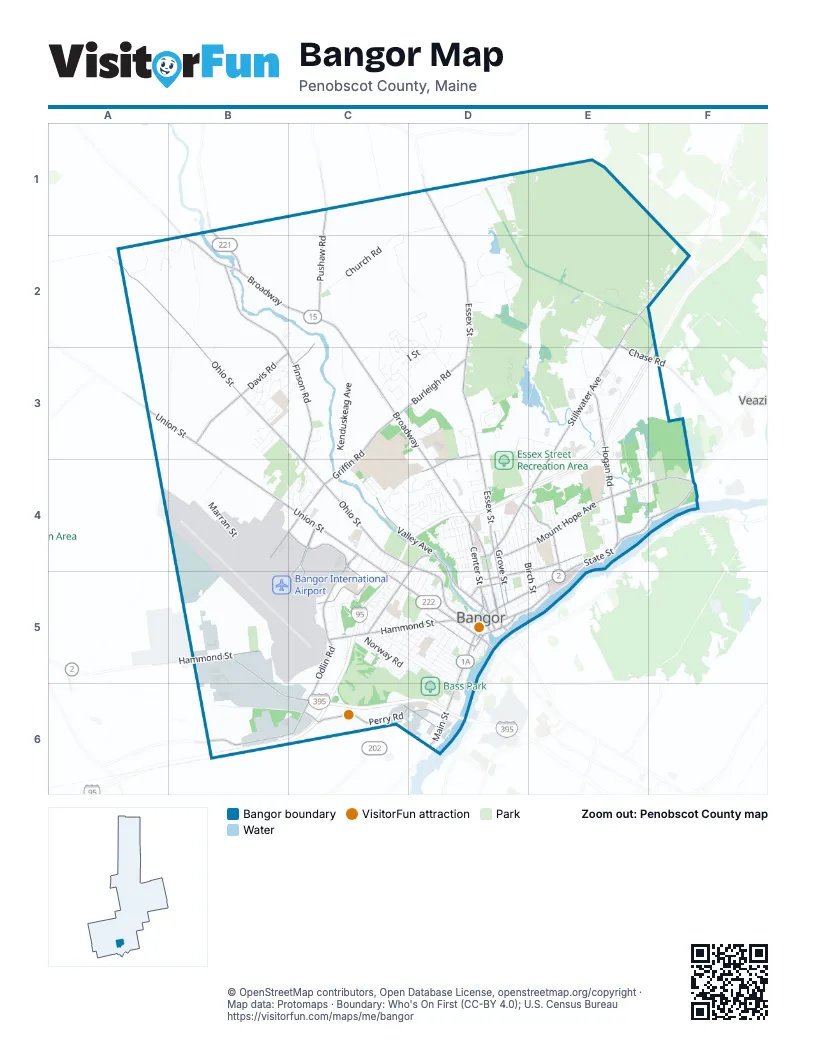
Street index of Bangor
Each street on the sheet and the grid squares it crosses.
- BroadwayB2, C2, C3, D3, D4, D5
- Union StreetA3, B3, B4, C4, C5, D5
- Hammond StreetB5, C5, D5, B6, C6
- State StreetE4, F4, D5, E5
- Odlin RoadC5, B6, C6
- Hogan RoadE3, E4
- Main StreetD5, D6
- Hancock StreetD5, E5
- Cedar StreetD5
- Harlow StreetD5
- Washington StreetD5
- Oak StreetD5
- Summer StreetD5
- Central StreetD5
- Independent StreetD5
- Gallagher PlaceD5
- Short StreetD5
- Stillwater AvenueE2, F2, E3, D4, E4
- Griffin RoadC3, B4, C4
- Maine AvenueC4, C5
- Hudson RoadB1, B2
- Vermont AvenueC4
- Ohio StreetA2, B2, B3, C4, D4, D5
- Essex StreetD1, D2, D3, D4, D5
- Finson RoadB2, B3, C3, C4
- Mount Hope AvenueD4, E4, F4
- Pushaw RoadC1, C2, C3
- Davis RoadB3
- Godfrey BoulevardC4, C5
- Perry RoadC6
- Valley AvenueC4, D4, D5
- Fourteenth StreetD4, C5, D5
- Garland StreetE4, D5
- Texas AvenueC4, C5
- Burleigh RoadC3, D3
- Howard StreetD4, E4, E5
- Center StreetD4, D5
- Grove StreetD4, D5
- Grandview AvenueD3, D4
- Chase RoadE2, E3, F3
- Thatcher StreetC6, D6
- Cumberland StreetD5
- Farm RoadD6
- Exchange StreetD5
- Park StreetD5
- Kenduskeag AvenueC2, C3, C4, D4, D5
- Church RoadC1, D1, C2
- Kittredge RoadE2, E3
- Birch StreetD4, E5
- Walden Parke WayD1
- Target Industrial CircleB5, B6
- Forest AvenueD4, D5
- Pearl StreetD4, E4, E5
- Lincoln StreetC5, D5, D6
- Fern StreetD4, E4, E5
- Buck StreetC5, D5, D6
- Fox HollowD2
- Skyline RoadC1, C2, D2
- Pine StreetD4, D5
- Maple StreetD4, D5
- Husson AvenueC4, D4
- West BroadwayC5, D5
- Webster AvenueC5, C6
- French StreetD4, D5
- Pine Circle DriveD3
- Bomarc RoadD2, D3
- Marran StreetB4
- Norway RoadC5, D5
- College CircleC4
- Tamarack TrailD1, D2
- Parkview AvenueD4, D5
- Elm StreetD4, D5
- Moosehead BoulevardB3, C3
- Fifteenth StreetC4, C5
- Hornbeam WayA2, B2
- Third StreetD5
- Silver RoadC5
- Sylvan RoadE3, E4
- Randolph DriveB4, C4
- Haskell RoadE3, E4
- Seventh StreetC5, D5
- Maineiac AvenueB4, C4
- Corporate DriveC5
- Bass Park BoulevardD5, D6
- Springer DriveE3
- Bolling DriveC4
- Palm StreetD4, D5
- Falvey StreetD4
- Larkin StreetD5
- Rolling Meadow DriveE3, E4, F4
- Longview DriveE3
- Yale StreetE4
- Juniper StreetD4, E4
- Bangor RacewayD5, D6
- Leighton StreetD4, D5
- Fountain StreetD4, D5
- Norfolk StreetD4, D5
- York StreetD5
- Prays Mobile Home ParkB2, C2
- Fruit StreetE4, E5
- Pine Ledge RoadA2
- Cedar Circle DriveD3
- Thirteenth StreetC5, D5
- Virginia LaneE3, E4
- Dartmouth StreetE4
- Fifth StreetD5
- Thornton RoadD4
- Bomarc Industrial ParkD2
- Judson BoulevardC3
- Kagan DriveC3, C4
- Ashley AvenueB4
- Laurel CircleD4
- Court StreetD5
- North Bangor RoadB2
- Hobart StreetD3, D4
- Gilman RoadD3, E3
- B StreetC2, C3
- Allen StreetC5
- Lasalle DriveC2, C3
- Hildreth Street NorthB5
- Linden StreetD4
- Backstage RoadD5, D6
- Balsam RoadC3, D3
- Downing RoadB4
- Saratoga AvenueE4
- Poplar StreetD4
- Somerset StreetD5
- Glenwood DriveC4
- Clyde RoadD4
- Florida AvenueC4, C5
- Bangor Mall BoulevardE3
- Second StreetD5
- Dunning BoulevardC4, C5
- Evergreen WoodsE4
- Mount Desert DriveB3
- Congress StreetD4
- Grant StreetD4
- Hildreth StreetB5, B6
- Thomas Hill RoadD5
- Banair RoadB5
- Sidney StreetD5
- Parker StreetD5
- Polk StreetB4, C4
- Deer Isle RoadB3, C3
- Langley StreetC4
- I StreetD2, C3, D3
- Pesch CircleB4
- H StreetC3, D3
- Packard DriveC3
- Walter StreetD5
- Crestmont RoadC5
- Husson WayC3, C4
- Sixth StreetD5
- Highland AvenueD5
- Birch Hill EstatesC3, D3
- Patten StreetD5
- Royal RoadC5
- Dirigo DriveB3
- Woodland DriveD3
- Sanford StreetD5
- Yankee AvenueB3
- Trillium TrailD2
- Savage StreetC5, D5
- Streamside LaneC3
- Sunny Hollow PlaceB3
- Bald Mountain DriveB3, C3
- Harthorn AvenueC5, D5
- Godsoe RoadC6, D6
- Sherman AvenueC4, D4
- Cortland CircleD3
- East StreetC2, D2, C5
- Drew LaneE3, E4
- G StreetD2, D3
- Mountain View AvenueC5, D5
- Cottage StreetD5
- Colonial Pines Mobile Home ParkB3, C3
- Orchard Hills ParkwayD3
- South Park StreetD4, D5
- Dowd RoadB6
- Maple LaneD3
- Montgomery StreetD4
- Pier StreetD5
- Farmhouse RoadC4, D4
- Tripp DriveF2
- Wiley StreetD4, D5
- Tower RoadB4
- State Hospital DriveE4
- C StreetC2, D2, C3
- Hempstead AvenueE4
- Severance StreetF3, F4
- Downeast CircleB3
- Boutelle RoadC5
- Jennifer LaneD3, D4, E4
- Baldwin DriveD3
- Venture WayC5
- Warren StreetD5
- James StreetD5
- Meadowbrook RoadE4, F4
- Blue Hill EastB3, C3
- Briarwood DriveD2, D3
- Otis StreetE4, E5
- Wildwood DriveD4
- Carol CourtD1
- Ernst ManorD4
- Joan's Hill RoadF2
- Fourth StreetD5
- Nason AvenueC5
- Shepherd DriveC3
- Hillside AvenueD4
- Forest ParkD5
- A StreetC2, C3
- Blue Hill WestB3
- Glenn AvenueB4
- Mildred AvenueC5
- Vernon StreetC5, D5
- Sable RidgeB3
- Front StreetD5
- Wing StreetC5, D5
- Fieldstone DriveD4
- Sunbury AvenueC4, D4
- New York StreetC5
- Olive StreetD6
- Rice StreetB5
- Bellevue AvenueE4, E5
- Heather RoadC3
- Spruce LaneD3
- Jefferson StreetD4, D5
- Market StreetD5
- Madison StreetD4
- Miller StreetB5
- Fort Knox AvenueB3
- Lupine WayD3
- Molly LaneD3, D4
- Smith StreetD5
- Hillview DriveC3
- Jowett StreetD4
- Birchwood AvenueB3
- Nelson StreetD5
- Knox AvenueC4, D4
- Ridgewood DriveE3
- Westland StreetC4
- Penobscot StreetD5
- Peruvian WayC2, C3
- Sixteenth StreetC4, C5
- Whisper DriveD3
- Benjamins WayD3
- Catell StreetD6
- FairwaysC5
- Chestnut TrailD2
- West StreetC5
- Harvard StreetE4
- Illinois AvenueB4, C4
- Seventeenth StreetC4
- Nowell RoadD4
- Eighteenth StreetC4
- Coffey StreetB5, B6
- Darling Parke DriveD3, D4
- Crosby StreetD6
- Glencove AvenueE4
- Division StreetD4, D5
- Doane StreetB5
- Bowdoin StreetD5
- Patrick LaneA2, B2
- East BroadwayD4
- Bean EstatesC4
- Valley View LaneC4
- Newbury StreetD5, E5
- Bunker LaneB2, B3
- Perkins StreetC5
- Dillingham StreetD6
- Whitetail WayD2
- Fairfax StreetC5
- Sugar Loaf LaneB3
- Bruce RoadC4, D4
- Kenduskeag Plaza WestD5
- Broad StreetD5
- Curve StreetD5
- Boyd StreetD5
- Franklin StreetD5
- Charles StreetD5
- Columbia StreetD5
- Fenton WayC3
- Ledge CircleC2
- Blackstone StreetD4
- Starling DriveC3, C4
- Holland StreetD4
- Labarca LaneD3
- Cleveland StreetC5
- Old Orchard DriveB3
- Merrimac StreetE5
- Meadow Farm RoadC4
- Dewitt AvenueD4
- Brewster StreetD4
- Clark AvenueD4
- Sunset AvenueC5
- Bentley AvenueF4
- Lancaster AvenueD4
- Ralph StreetC5
- Nicole CourtC4
- Summit AvenueE4
Things to do on the Bangor map
Places on the map
- Bangor Air National Guard Base
- Bangor High School
- Bangor Historical Society Library
- Bangor International Airport
- Bangor Mall
- Bangor Mental Health Institute Health Science Library
- Bangor Municipal Golf Course
- Bangor Raceway
- Bass Park
- Beth Abraham Cemetery
- Black Bear Lawn Care
- Bomarc Industrial Park
- Broadway Park
- Broadway Shopping Center
- Brown Woods
- Camden National Bank
- Cascade Park
- Central Penjajawoc Preserve
- Dorothea Dix Psychiatric Center
- Eastern Maine Medical Center
- Essex Street Recreation Area
- Gateway Park
- Hayford Park
- Kenduskeag Parkway
- Kenduskeag Stream Park
- Maine Army National Guard Bangor Training Site
- Maine Savings Ampitheater
- Mount Hope Cemetery
- Mount Pleasant Cemetery
- North Penjajawoc Forest
- Northeast Penjajawoc Preserve
- Northern Light Acadia Hospital
- Oak Ridge Business Park
- Penjajawoc Marsh
- Quirk Auto Park
- Rolland F. Perry City Forest
- Saint Joseph Healthcare Park
- Saxl Park
- Walden-Parke Preserve
Next to Bangor
- Brewer
- Veazie
© OpenStreetMap contributors, Open Database License, openstreetmap.org/copyright · Map data: Protomaps · Boundary: Who's On First (CC-BY 4.0); U.S. Census Bureau















