

Maine map
Lewiston map
About 38,772 people live here (Census Bureau, 2024 estimate). The sheet's index lists 300 streets; Lisbon Street, College Street and Ferry Road cross the most grid squares. Also on it: Garcelon Bog, Garcelon Bog Conservation Area and McMahon Field and Trails.
Open the map (PDF, US Letter)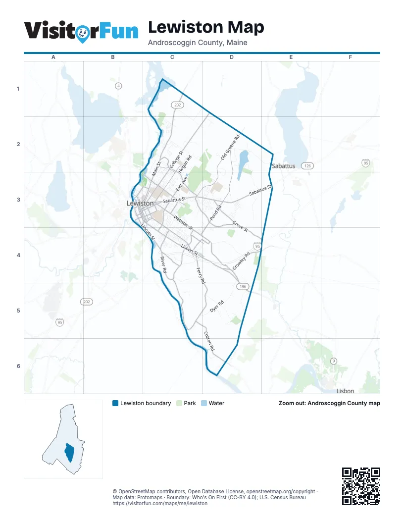
Street index of Lewiston
Each street on the sheet and the grid squares it crosses.
- Maine TurnpikeC4, D4
- Lisbon StreetB3, C3, C4, D4, D5
- Main StreetC1, C2, B3, C3
- Sabattus StreetB3, C3, D3, E3
- Russell StreetB3, C3
- Alfred A Plourde ParkwayC4
- Lincoln StreetB3, C3, C4
- Canal StreetB3, C3
- Cedar StreetB3, C3
- Route 202C1
- Court StreetB3
- College StreetD1, C2, D2, B3, C3
- River RoadC4, C5
- Old Greene RoadD2, C3, D3
- Webster StreetC3, C4, D4
- East AvenueC3, C4
- Montello StreetC2, C3
- Pleasant StreetC3, C4
- Pine StreetB3, C3
- Ash StreetB3, C3
- Farwell StreetC3
- Mollison WayC2
- Fair StreetC2, C3
- Connector RoadC3
- Pond RoadD2, D3, C4, D4
- Ferry RoadC4, D4, C5, D5, D6
- Grove StreetD3, D4, E4
- Randall RoadC3, D3
- Cotton RoadC5, D5, D6
- Central AvenueC2, C3
- Crowley RoadD4
- Old Lisbon RoadD4
- Bartlett StreetC3
- Goddard RoadC4
- South Lisbon RoadD4
- Bates StreetB3, C3
- South AvenueC4
- Park StreetB3, C3
- Oak StreetB3, C3
- Birch StreetC3
- Westminster StreetC4
- Lexington StreetC4, D4
- Summer StreetB3, C3
- Commercial StreetC4
- Forrestal StreetC4, D4
- Middle StreetB3, C3
- Adams AvenueC3
- Chestnut StreetB3, C3
- Maple StreetC3
- Jefferson StreetC3
- Riverside StreetC3
- Locust StreetB3, C3
- West Bates StreetB3
- Sawyer RoadE2
- Greene StreetE2
- Dyer RoadD4, C5, D5
- No Name Pond RoadD2, E2
- Pinewoods RoadD5
- Old Webster RoadD4
- Bradbury RoadD2, D3
- Stetson RoadC2
- Webber AvenueC3, C4
- Switzerland RoadC1, C2
- Merrill RoadC1, C2
- Gayton RoadD5
- Strawberry AvenueC2, C3
- Hogan RoadC2, C3
- Scribner BoulevardC3, C4
- Gendron DriveC4
- Lewiston Landfill Access RoadC5
- Old Chadbourne RoadD3, E3
- Blake StreetB3, C3
- Campus AvenueC3
- Rideout AvenueD3
- Heather DriveC2
- North Temple StreetD3
- Village DriveD3
- Pond Ridge RoadD2
- Holland StreetB3, C3
- Apple RoadC4
- C M P Co Private RoadC1
- Sleeper RoadC1, D1, C2
- Beaumont LaneD3
- Sherbrooke AvenueC3, D3
- Pettingill StreetC3
- Walnut StreetC3
- Woodside DriveC4, D4
- Ashmount StreetC4
- Reginald LaneD6
- Greenwood LaneD2
- Rosedale StreetC4
- Golder RoadD3
- Mill StreetB3
- Foss RoadD4, D5
- Matobian AvenueD2, D3
- Commons DriveD6
- Bardwell StreetC3
- Tall Pines DriveC2
- Highland AvenueC3
- Shore RoadD2
- Horton StreetC3
- Woodhaven DriveD5
- Oxford StreetB3
- Spring StreetB3, C3
- Pagoma LaneC3
- Warren AvenueC3
- Cottage StreetC3
- Hillview LaneC3
- Martin DriveC4
- Stevens StreetC3
- Canal Street AlleyB3, C3
- Howe StreetC3
- Wood StreetC3
- Fairmount StreetC4
- Autumn LaneD3
- Challenger DriveC4
- Charles StreetC3
- Saint Patrick AvenueC2
- Cote StreetC3, C4
- Tampa StreetC3
- Amos CourtC2
- East Merrill RoadC1, C2, D2
- Caldwell CircleD5
- Vale StreetC3
- Deer RoadC2
- Buttonwood LaneC2, C3
- Nichols StreetC3
- Saratoga StreetC4, D4
- Fisher AvenueD3
- High StreetB3, C3
- McArthur AvenueC2
- Montello School DriveC3
- Old Farm RoadD2
- Oxbow DriveD3
- North Lisbon RoadD4
- Pierce StreetC3
- Mark StreetD3
- Strawberry Patch RoadC3, C4
- Boston AvenueC3
- Gina StreetD3
- Waters Edge DriveD2
- Jeffrey StreetC4
- Wellman StreetC3
- Bailey AvenueD3
- Morris AvenueC3
- Sheffield AvenueC3, D3, D4
- Manning AvenueC2, C3
- Bowdoin DriveC2
- Jordan RoadD5
- Rejane AvenueC2
- Dow AvenueD3
- Jean StreetC3
- Rachel BoulevardD3
- Essex StreetC4
- Robinson GardensC3
- Biron AvenueC4
- Mitchell StreetC4
- Moody RoadD5
- Shawmut StreetC3
- King AvenueC2
- Randall Road Ballfields AccessD3, D4
- School StreetD3
- Whipple StreetB3, C3
- Kensington TerraceC3
- McNamara StreetC3
- Kevin StreetD3
- Champlain AvenueC2
- Franklin StreetC3
- Sylvan AvenueC3
- Sand Hill RoadC4
- Almod AvenueD3, D4
- Garcelon StreetC3, D3
- Lafayette StreetC3
- Dumont AvenueC4
- Prospect AvenueC4
- Androscoggin AvenueC3, C4
- Brooks AvenueC3
- Dimsdale AvenueC3
- Knox StreetC3
- Chadbourne RoadD3
- Pineland StreetC3, C4
- Googin StreetC3
- Acadia AvenueC4
- Highland Spring RoadC3
- Mower AvenueC2
- Hillmount DriveC4
- Elm StreetC3
- Fairlawn AvenueC3
- Brault StreetC3
- Winter StreetB3
- Baird AvenueC4
- Saint Croix StreetC4
- Marguerette StreetC3
- Ware StreetC3
- Fortin WayC3
- Avon StreetB3
- Reservoir AvenueC3
- Bushey CircleC3
- Hilltop AvenueC3
- Nob Hill AvenueC3
- Razel WayC4
- Squire LaneD5
- Delcliff LaneC3
- Lincoln Street AlleyB3
- Ventura StreetC2, C3
- Lemont AvenueC3
- Park Street AlleyB3
- Valley StreetC4
- Leavitt AvenueC3
- Summit AvenueC4
- Howard StreetC3
- Orchard CircleD3
- Orestis WayC3
- Ridgewood AvenueC3, D3
- Mountain AvenueC3
- Orleans StreetC3
- Northwood RoadC2
- Jans BoulevardC3, C4
- Cassell StreetC4
- Cherrywood DriveD3
- Pearl StreetC3
- Allen AvenueC3
- Cortland WayD5
- Scribner CircleC4
- Maplewood RoadC3, C4
- Dill StreetC4
- Barron AvenueC3
- Bradley StreetC3
- Jill StreetC3, C4
- Circle DriveD3
- First StreetC4
- Libby AvenueC3
- Taylor Hill RoadC1
- Mount Hope AvenueC4
- Bridge StreetB3
- Lawpca Access RoadC4
- Orange StreetC3
- Willow CircleC3
- Gloria AvenueD3
- Eustis StreetC4
- Larrabee RoadC2
- Ann StreetD3
- McKinley DriveC2
- Macadamia LaneD3, D4
- Jones AvenueC4
- Peter BoulevardD3
- Swale LaneC4
- Walker AvenueC3
- Fireslate PlaceD2
- Foch StreetC4
- Fox Run DriveD3
- Novella StreetC2, C3
- Laurier StreetC3
- Woodville RoadC3
- Simard AvenueC4
- Crestview DriveD3, D4
- Hackett StreetC3
- Irwin StreetC4
- Sunset Gardens Mobile HomeD5
- Sarah AvenueC2
- Katie AvenueC2
- Heathwood LaneC4
- Old Bloody Hill RoadD3
- Owens StreetC3
- Wildwood DriveC3
- Perley StreetC3
- Frye StreetC3
- Midway StreetC4
- Class StreetD3
- Cram AvenueC3, D3
- Gulf Island AvenueC1, C2
- Elliot AvenueC2
- Albert StreetC4
- Bosse StreetC3
- Saint Jerome StreetD3
- Gagne StreetC4
- Rosewood AvenueC4
- Merton BoulevardC4
- Hartley StreetD3
- Nimitz StreetC2
- Treemount DriveC4
- Martha AvenueC3
- Mary StreetC4
- Columbia StreetC3
- Enterprise StreetC4
- Linda CircleD3
- Michaud AvenueC2
- Robert AvenueC3
- Surry LaneC2
- Tourmaline DriveD4
- Jeannette AvenueC3
- Lemay AvenueC2
- South Pleasant RoadC4
- Morningside StreetC4
- Darcey DriveD3
- Harmony LaneD3
- River StreetB3
- Lochview DriveD3
- Lowell StreetB3
- Dawn AvenueC4
Places on the map
- Apple Valley Golf Course
- Bates College
- Central Maine Medical Center
- Clough Cemetery
- David Rancourt River Preserve
- Drouin Field
- Farwell Elementary School
- Franco Center
- Franklin Pasture Track
- Garcelon Bog
- Garcelon Bog Conservation Area
- Gerrish True Health Science Library
- Grand Army Cemetery
- Hedgehog Hill
- Joseph Deschenes Field
- Kennedy Park
- Leahey Field
- Lepage Bakeries
- Lewiston High School
- Lewiston Mall
- Lewiston Middle School
- Lincoln Street Park
- Marcotte Nursing Home
- Marden's
- McMahon Field and Trails
- Montello Elementary School
- Montello Heights Reservoir
- Mount David
- Mount Hope Cemetery
- No Name Pond
- No Name Pond Conservation Area
- Randall Road Softball Complex
- Raymond A. Geiger Elementary School
- Riverside Cemetery
- Robert V. Connors Elementary School
- Robinson Mountain
- Russell Street Track
- Saint Peter's Cemetery
- Thorncrag Nature Sanctuary
Next to Lewiston
- Lisbon
- Sabattus
© OpenStreetMap contributors, Open Database License, openstreetmap.org/copyright · Map data: Protomaps · Boundary: Who's On First (CC-BY 4.0); U.S. Census Bureau















