

Michigan map
Dearborn Heights map
About 61,040 people live here (Census Bureau, 2024 estimate). The sheet's index lists 300 streets; Ann Arbor Trail, North Evangeline Street and Ford Road cross the most grid squares. Also on it: A&C Auto Care, Al Shallal and ALDI.
Open the map (PDF, US Letter)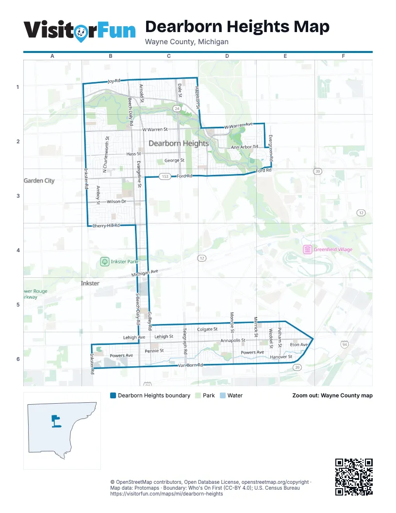
Street index of Dearborn Heights
Each street on the sheet and the grid squares it crosses.
- Southfield FreewayE6
- North Telegraph RoadC1, C2, C3
- Ford RoadB3, C3, D3, E3
- South Telegraph RoadC5, C6
- Michigan AvenueC4
- Telegraph RoadC6
- Van Born RoadB6, C6, D6, E6
- Inkster RoadB1, B2, B3, B6
- Beech Daly RoadB1, B2, B3, B4
- West Warren StreetB2, C2
- West Outer DriveD2, D3
- South Beech Daly RoadB4, B5, B6
- Joy RoadB1, C1
- West Warren AvenueC2, D2, E2
- Cherry Hill RoadB4, C4
- South M 39 Service DriveE6
- South Beech Daly StreetB6
- North Inkster RoadB1
- Ann Arbor TrailB1, C1, C2, D2, E2
- Annapolis StreetB6, C6, D6, E6
- Edward N. Hines DriveB1, C1, C2, D2
- Wilson DriveB3, C3
- Hass StreetB2, C2
- South Gulley RoadC4, C5, C6
- North Gulley RoadB1, C2, C3
- Pelham StreetE5, E6
- Monroe StreetD5, D6
- Evergreen RoadE2
- Avondale AvenueC4
- Marquette StreetB3
- Maplewood AvenueB2
- Monroe BoulevardD6
- Powers AvenueB6, C6, D6, E6
- Colgate StreetC5, D5, E5, E6
- Lehigh StreetC6, D6, E6
- Hanover StreetB6, C6, D6, E6
- Eton AvenueB6, C6, D6, E6
- North Charlesworth StreetB1, B2, B3, B4
- Amboy StreetB1, B2, B3, B4
- North Evangeline StreetB1, B2, B3, C3, C4
- Robindale AvenueC1, C2, C3
- Whitefield StreetB1, B2, B3
- Richardson StreetB2, C2
- North Silvery LaneC1, C2
- Kinmore StreetB1, C2, C3
- Fenton StreetC1, C2, C3
- Nightingale StreetC1, C2, C3
- Plainfield StreetB2, B3, B4
- Pennie StreetB6, C6
- Colonial StreetC1, C2, C3
- Midway StreetB2, C2, B3, C3
- Highview StreetC2, C3
- Kennedy StreetB2, C2
- Norborne AvenueB2, B3, B4
- Kinloch StreetB2, B3
- Kingsbury StreetC1, C2, C3
- Rosemary StreetB1, B2, B3
- Berwyn StreetB2, B3
- Constance StreetB1, C1
- Drexel StreetC2, C3
- McDonald StreetB6, C6
- Currier StreetB6, C6
- Midway AvenueB2, C2, D2, B3
- Dartmouth StreetB5, C5, E5
- Centralia StreetB2, B3
- Merrick StreetD5, E6
- North Lafayette StreetC1, C2
- Fairwood DriveB2, B3
- North Vernon StreetC2
- Harding StreetD5, D6
- Mayburn StreetC2, C3
- Dudley StreetD5, D6
- Madison StreetC5, C6, D6
- Academy StreetD5, D6
- North John Daly RoadB3, B4
- Rouge River DriveB1, C1, B2, C2
- Hopkins StreetB6, C6
- Andover DriveB5, C5
- West Point StreetC5, C6
- Cornell StreetC5, C6
- Detroit StreetE5, E6
- Syracuse StreetC5, C6
- Banner StreetC5, C6
- Hipp StreetE5, E6
- Cronin DriveB2, B3
- Grindley Park StreetD5, D6
- Polk StreetE5, E6
- Weddel StreetE5, E6
- Williams StreetD5, D6
- Mayfair StreetE5, E6
- Katherine StreetD5, D6
- Park DriveB1, C1
- Clippert StreetD5, D6
- Pardee AvenueD5, D6
- Jackson StreetE5, E6
- Campbell StreetD5, D6
- Kingston StreetE5, E6
- Timber TrailB3
- Gertrude StreetD6
- North Waverly StreetC2, C3
- Culver StreetE5, E6
- Edgewood StreetE5, E6
- Hazelton StreetC1, D1, D2
- Van Buren StreetB1, C1
- North Highland AvenueC2, C3
- Sheahan DriveB3
- Fairview DriveD2, E2
- Huron StreetE5, E6
- Ziegler StreetE5, E6
- Grayfield StreetC1
- Doxtator StreetB3
- Roosevelt BoulevardD5, D6
- Lincoln BoulevardD5, D6
- Stanford StreetC6
- Cecile StreetB3
- Clairview DriveB1, B2, C2
- McKinley StreetD5, D6
- Rockland StreetB1, B2
- Lehigh AvenueC6
- Bailey AvenueC5, C6
- Janet StreetC5, C6
- Simone StreetB3
- Croissant StreetE5, E6
- Amherst StreetB6, C6
- Hazel StreetB6
- Baldwin StreetB2
- Glenis StreetB6
- Howard Cassidy DriveD2
- Belton AvenueC1, D1
- Appleton StreetC1
- Burger StreetD2, D3
- Arnold StreetB1, C1
- Riverdale StreetC1
- Bedford StreetE5, E6
- Virgil StreetC1
- Kingswood DriveB3
- Riverview StreetC1
- Lochdale StreetC1
- Garling DriveD2, E2
- Dale StreetC1
- Dacosta StreetD2, D3
- Brooklawn DriveD2, E2
- Eton StreetB6, C6, D6
- George AvenueB2, C2
- Vassar StreetD5, D6
- Fielding StreetE2
- Westlake StreetC5, C6
- Lenore AvenueC1
- Van Buren RoadB1, C1
- Parker StreetD5, D6
- Lawrence DriveB3
- Whitlock DriveD2, E2
- Rochelle StreetB3
- Cambourne RoadB2, B3
- Military RoadC2, D2
- George StreetC2
- Raymond AvenueE6
- Wormer AvenueC1
- Warrington StreetB2
- Heyden AvenueE2
- Rockdale StreetD2
- Cambridge StreetB2
- Fellrath AvenueB6
- University DriveD2
- Brookwood StreetD2, E2
- Dixie LaneC1
- Dolphin StreetD2
- Parkway CircleC2, D2
- Old Colony RoadE2
- Riverside DriveC2, D2
- Oldham StreetC6
- River Oaks DriveD2, E2
- Shadowlawn StreetB2
- Graceland CircleB4, C4
- Parkland StreetC1, D2
- Tulane StreetD5, D6
- TerrellB3
- Rosetta StreetC2, C3
- Fordson HighwayC1
- Hubbell StreetD2
- Campus DriveD2
- Salem LaneC1
- Bayhan AvenueB6
- Northmore StreetB3
- Tireman StreetB1, C1, D1
- North Brookside DriveD6
- Winston LaneC1
- Glengary StreetB1
- Fleming StreetE6
- Beechcrest StreetD2, D3
- Trowbridge StreetB5
- Golfview DriveD2, D3
- Coolidge StreetB2, B3
- Canfield DriveB1, B3
- South Brookside DriveD6
- Princess StreetB6
- Cranford LaneB3
- BeechwoodB3, C3
- Vivian StreetC5, C6
- WarrendaleC2
- Crestmont LaneD2
- BerwynB1
- North Martha StreetD2, D3
- Elon DriveB2, C2
- Legacy Park CircleC1
- MercedesB1
- Nollar DriveB1
- Woodworth CircleB2
- Yorkshire BoulevardB3, B4
- Central Park DriveB3
- Heather LaneD6
- Williamsburg RoadD2, E2
- Figueroa StreetB2
- Lila LaneB3
- Parkland DriveD2
- WoodbineC1
- Havelock DriveB3
- Hickory CourtB2
- Inkster Service DriveB3
- Yale StreetB5, C5
- Norfolk StreetB5, C5
- Universal StreetE6
- Beaver StreetD2
- Bonair StreetC2, D2
- McMillan StreetD2, D3
- Rouge CircleD2, D3
- Doxtator AvenueB3, C3
- Dover StreetB3
- Cranford StreetB3
- Kean StreetC4
- South John Daly RoadB6
- West Hills DriveB4, C4
- Colgate AvenueC5
- Ross StreetC5
- Stanford AvenueC6
- Carlysle StreetC5
- Notre Dame StreetC5
- New York StreetC5
- Princeton StreetB5, C5
- Blossingham DriveB4, C4
- Woodshire AvenueB2
- Marshall StreetC4
- Oakland DriveB4, C4
- Sherbourne DriveB3
- Bon Telegraph DriveC1
- Meadlawn DriveC2, C3, D3
- Belmont StreetD2, D3
- CentraliaB1
- Lamphere StreetD2
- Woodbine StreetC1
- Troy StreetC6
- Burr StreetC6
- Cherokee StreetC6
- Circle DriveD2
- Dwight StreetB2
- NorborneB1
- Cooper StreetC6
- Longview StreetC2, D2
- Deerfield StreetB3
- Hendrickson AvenueB3
- Westphal DriveB3, B4
- Hickory Wood DriveD3
- John Daly StreetB4, B6
- San JoseB1
- Loch Lomond DriveB4, C4
- KinlochB1
- Crestwood StreetB2
- Wellington DriveB6
- Cranbrook StreetD6
- Bryan StreetB2
- Michael StreetC6
- Golfview StreetB1, B2
- ElizabethD2
- 1st StreetB2, D2
- Bayham StreetB6
- Biltmore DriveB3, B4
- Cummings StreetB6
- Lawrence StreetB3, C3
- Windsor StreetB2
- Sylvia StreetB6
- Andover StreetB5
- Emery AvenueD2
- ColumbiaB1
- Coonville DriveD2
- HillC2, D2
- Keith StreetB1
- Town LaneE2
- College DriveD2
- 3rd StreetB2, D2
- West Brookside DriveD6
- Americana BoulevardB3
- Hampden StreetB6
- Robinson StreetE6
- Rockland CourtB2, B3
- Daniels StreetB6
- Fellrath StreetB6
- Ardmore StreetB3
- Lana CourtC4
- Shirley LaneB3
- Henry StreetC1
Places on the map
- A&C Auto Care
- Al Shallal
- ALDI
- Alleluia Romanian Pentecostal Church
- American House Dearborn Heights
- Ananas Cafe
- Angelo G. Batsakis Sports Park
- Annapolis Baseball Field
- Annapolis High School
- Applebee's
- Arbor Lane Medical Village
- AutoZone
- Ball Diamond "A"
- Ball Diamond "B"
- Central Park
- Cherry Hill Baptist Church
- Crestwood High School
- Field of Dreams
- Helm's Haven Recreation Area
- Lyle C. Van Houten Park
- Mariannhill Missionaries
- Michael Berry Career Center
- Middle River Rouge
- Nolar Bend Recreation Area
- Pardee Athletic Fields
- Parkland Community Park
- Parkland Recreation Area
- Parr Recreation Area
- River Oaks Elementary School
- Rouge River
- Saint Hedwig Cemetery
- Saint Mel Catholic School
- Star International Academy
- Swapka Park
- The Heights
- The Home Depot
- Vista Maria
- Wallaceville Soccer Fields
- Warren Valley Golf Course
- Warrendale Recreation Area
Next to Dearborn Heights
- Garden City
- Inkster
© OpenStreetMap contributors, Open Database License, openstreetmap.org/copyright · Map data: Protomaps · Boundary: Who's On First (CC-BY 4.0); U.S. Census Bureau