

Michigan map
Emmet County map
About 33,949 people live here (Census Bureau, 2024 estimate). The sheet's index lists 300 streets; Maple Street, Main Street and North Lake Shore Drive cross the most grid squares. Things to do inside the boundary: Colonial Michilimackinac, Odawa Casino Resort and Petoskey State Park.
Open the map (PDF, US Letter)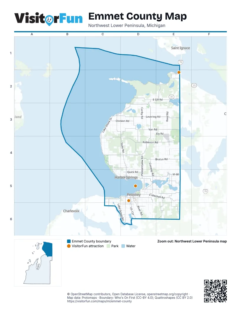
Street index of Emmet County
Each street on the sheet and the grid squares it crosses.
- North Lake Shore DriveD2, C3, D3, C4
- South Lake Shore DriveC4, C5, D5
- Charlevoix AvenueC5, D5
- Harbor Springs - Petoskey RoadD5
- US-131D5, D6
- State StreetE4, D5
- Oden RoadD5, E5
- M-68E5
- North US-31 HighwayD5
- Stimpson StreetE4
- East Mitchell StreetD5
- Sunset BoulevardE2, D5, E5
- Spring StreetD5, E5
- Mackinaw HighwayE4
- Burr AvenueE5
- Woodland AvenueD5, E5
- Chicago StreetE5
- East Main StreetD5
- West Bluff DriveD5
- Bay View RoadD5
- Merritt StreetD5
- West Mitchell StreetD5
- US 131 NorthD6
- Pleasantview RoadD2, D3, D4, D5
- Robinson RoadC4, D4, E4
- East Mitchell RoadD5, E5, E6
- Wilderness Park DriveD2, E2
- East Levering RoadD3, E3
- South State RoadD4, D5
- North State RoadC3, D3, D4
- West Levering RoadC3, D3
- East Gill RoadD2, E2
- Atkins RoadD5
- Division RoadC3, D3, D5
- River RoadD5, D6
- North Mackinaw HighwayE2
- Cecil Bay RoadE2
- McDougal RoadD5, D6
- Click RoadD6
- West Central AvenueE2
- Bear River RoadD6, E6
- Mill StreetE3, E4, D5
- Horton Bay RoadC5, C6
- East Lake StreetD5
- South Nicolet StreetE2
- North Division RoadD5
- South Division RoadD5
- East Central AvenueE2
- Park LaneC3, D5
- State RoadD4
- Levering RoadE3
- Pickerel Lake RoadD5, E5
- West Stutsmanville RoadC4, D4
- East Brutus RoadD4, E4
- East Van RoadD3, E3
- West Van RoadD3
- Banwell RoadE5
- North Larks Lake RoadD3, D4
- Resort PikeD5, D6
- Maxwell RoadE5, E6
- North Conway RoadD4, D5
- Lakeview RoadD2, E5
- Quick RoadD5
- Middle RoadC4, D4
- Intertown RoadC6, D6
- Powers RoadD5, E5
- South Larks Lake RoadD4
- Paradise TrailE2
- Bellmer RoadD5
- West Sturgeon Bay TrailD3
- Trails End RoadE2, E5
- Wildwood RoadE5
- West Conway RoadD5
- East Hathaway RoadD5
- Miller RoadE5
- West Lake RoadC5, D5
- West Sheridan RoadD5
- South Ellsworth RoadE5
- East Sturgeon Bay TrailD3
- East Robinson RoadD4, E4
- Howard StreetD5
- Anderson RoadD5, D6
- Graham RoadD5, E5
- West Lakeview RoadD2
- Blanchard RoadE5
- Newson RoadE6
- Morford RoadD6
- Emmet StreetD5
- Standish AvenueD5
- West Robinson RoadD4
- Traverse StreetD5
- East Bay StreetD5
- East 3rd StreetD5
- Louvingny StreetE2
- West 3rd StreetD5
- West Jamet StreetE2
- West Bay StreetD5
- East Sheridan StreetD5
- North Nicolet StreetE2
- Brutus RoadE4
- Judd StreetD5
- Straits AvenueE2
- MapleE2, D5
- West Main StreetD5
- South Howard RoadD5
- Gardner StreetD5
- Sheridan StreetD5
- North Huron AvenueE2
- Hankey StreetD5
- Cobb RoadE6
- Palmer RoadD4
- Valley RoadD3, D4, E4, E5
- Reed RoadE2, E3
- Greenwood RoadD5, D6, E6
- Canby RoadD2, D3
- Lake Grove RoadC5, C6, D6
- North Ayr RoadD4
- Beckon RoadC3, D3
- Schmalzried RoadD3, E3
- Munger RoadD2, D3, E3
- Middle Village DriveC4, D4
- Mission RoadE4, E5
- Tower RoadD4, E4
- Gregory RoadD3, D4, E4
- Indian Garden RoadD6
- Cemetery RoadD3, D5, D6
- Ely RoadD3, E3
- Howard RoadD5, D6
- Blackbird RoadD5, D6
- Red School RoadE4
- Hughston RoadC4, C5, D5
- Milton RoadE4, E5
- Welsheimer RoadD4
- Lower Shore DriveC4, C5
- Evergreen TrailD6
- Lightfoot RoadD4, D5
- Channel RoadE5
- Sunny Ridge RoadE4
- Johnson RoadE4, D6, E6
- Terpening RoadC4
- Camp RoadD4, E4
- Island View RoadC3
- Hopper RoadE6
- West Townline RoadC4
- Hedrick RoadD4, D5
- Plains RoadE4
- Cedar Valley RoadD5, D6
- Linsley RoadE2
- Luesing RoadD3, E3
- Old US-31E2, C5
- Hoyt StreetD4, D5
- Elder RoadD2, E2
- Waugoshance Point RoadD2
- Country Club RoadD5
- West Bliss RoadD2, D3
- Catob RoadD4, D5
- Sommers RoadE3
- Douglas Lake RoadE3, E4
- Woodland RoadE4
- GreenbriarC4, C5
- 5 Mile Creek RoadC4
- Moore RoadE5
- Ball RoadE3
- Wressel RoadC4, D4
- Zmikly RoadD3
- Crooked Tree DriveC5, D5
- Durkalic RoadE4
- Emmet Heights RoadD4, D5
- Beach RoadD5
- Crump RoadE4, E5
- Welsch RoadE6
- Crooked River RoadE4
- Heynig RoadD4
- Heather DriveD4
- Berger RoadE5, E6
- Hiawatha TrailD5
- Cupp RoadE4
- Drier RoadE3
- Edwards RoadD4, E4
- Garber RoadD3
- Brubaker RoadD5, D6
- Orchard RoadE3
- Cassidy RoadD3
- Bester RoadD5
- Oak DriveC3
- Russett RoadD6
- Martinchek RoadC5
- Eppler RoadD5, D6
- Townsend RoadC5, C6
- Beach DriveD5, E5
- East Gruler RoadD6
- Wormwood LaneC3, D3
- Rustic RoadD5, E5
- Pennsylvania AvenueD5
- Maplewood DriveD5
- Wilderness Road NorthC3, C4
- Camp Daggett RoadC5, C6
- Church RoadC3, C4, C5
- Coors RoadE5
- Rugged RoadD3
- Wheeling RoadE2
- Lockwood RoadE4
- East Branch TrailE3, E4
- Keiser RoadD3
- Stolt RoadC6
- Timber PassC4, C5
- Ellis RoadD2
- Powell RoadD5
- Maple StreetE2, E3, E4, D5, E5
- Petoskey State ParkD5
- Hideaway Valley DriveD5
- North Barney RoadE4, E5
- Hill RoadD3
- Glenn DriveD5
- Armock RoadE5
- Townline RoadE4, C5, C6
- Krause RoadD6
- Smith RoadE5
- Vorce RoadC3
- Sturgeon Bay DriveD3
- Osborne RoadC3, D3
- Gully RoadC3
- Williams RoadD6
- Twildo RoadE5, E6
- Maple River RoadE4
- Lacount RoadC4, D4
- Sand RoadE4
- Kolinske RoadD5
- Snider RoadE4
- Birchwood DriveC4, C5
- South Lamkin RoadC4
- Hayes LaneE2
- Pine TrailE4, C5
- Preserve DriveC5
- Chippewa DriveC3, D3
- Fisher RoadC4, D4
- Culp RoadE4
- Lakeside DriveE2, D5
- Clayton RoadD5
- Chippewa TrailC4, D5
- East Bear River RoadD6
- Heaton RoadE6
- Trillium TrailC4, C5
- Washington StreetE4, D5
- Straits View DriveE2
- Trick RoadC3
- Hurd RoadC4, D4
- Sterzik RoadD5, D6
- Dayton RoadD4, D5
- Turfway TrailC4
- Lears RoadD5
- Milton StreetE4
- South Durkalic RoadE4
- Odawa CircleD5
- Main StreetE3, E4, C5, D5, E5
- Old School House RoadE3
- North Ellsworth RoadE5
- Boynton RoadC4
- Country Knolls RoadD5
- Nichols RoadD3
- Hemlock LaneD4, E4, D6
- West Lake StreetD5
- South Preserve DriveC5
- Vista DriveC5
- North Lamkin RoadC4
- Roy RoadE5
- Camp Petosega RoadE5
- Highland RoadE3, D4
- Joy LaneE6
- Petoskey StreetD5, E5
- Mink RoadD5
- Ridge RoadE2, C5
- Stradling RoadD6
- True North DriveD4
- Ringler RoadE4
- Sturgeon Bay RoadD2
- North Fletcher RoadD5
- Dark Sky Discovery RoadE2
- Stump RoadC6, D6
- Shanley RoadD5
- Silver Creek RoadE5
- Lone Rock RoadC4
- West Hathaway RoadD5
- Cetas RoadD4
- Kugler RoadE4
- Ely Bridge RoadD3, D4
- Zipf StreetE4
- One Mile RoadD3
- Nubs Nob RoadD4
- Pyjar RoadD3
- Gregg RoadD6
- Berry Creek ValleyE6
- Kemp RoadD6
- Dekruif RoadE3
- Coastal Ridge DriveC5
- Barney RoadD5, E5
- Warwick RoadD4
- Felter DriveE5
- Lintlong RoadD6
- Oliver RoadE2
Things to do on the Emmet County map
Places on the map
- Alanson
- Arthur Hills
- Bay Harbor Golf Club
- Bay View Woods Park
- Bayfront Park
- Bear Creek Township
- Bear River
- Beginner Trail
- Birchwood Farms Golf & Country Club
- Black Hole Nature Preserve
- Bliss Township
- Boyne Highlands Resort
- Bryan Wildlife Nature Preserve
- Camp Petosega
- Carp Lake Township
- Cecil Bay Park
- Center Township
- Chestnut Valley Golf Course
- Commercial Forest
- Crooked Lake
- Crooked River
- Crooked Tree Golf Club
- Cross Village Township
- Donald Ross Memorial
- Elbert Family Nature Preserve
- Elmer Johnston Nature Preserve
- Fochtman Nature Preserve
- Four Lakes
- French Farm Lake
- Friendship Township
- Goodhart Farms Nature Preserve
- Harbor Point Golf Club
- Harbor Springs
- Hearthside Grove
- Hymas Woods Nature Preserve
- Lake Paradise
- Larks Lake
- Levering
- Little Traverse Township
- Littlefield Township
Next to Emmet County
- Charlevoix
- Saint Ignace
© OpenStreetMap contributors, Open Database License, openstreetmap.org/copyright · Map data: Protomaps · Boundary: Who's On First (CC-BY 4.0); Quattroshapes (CC BY 2.0)















