

Michigan map
Hamtramck map
About 27,424 people live here (Census Bureau, 2024 estimate). The sheet's index lists 104 streets; Joseph Campau Street, McDougall Street and Lumpkin Street cross the most grid squares. Things to do inside the boundary: Polish Art Center.
Open the map (PDF, US Letter)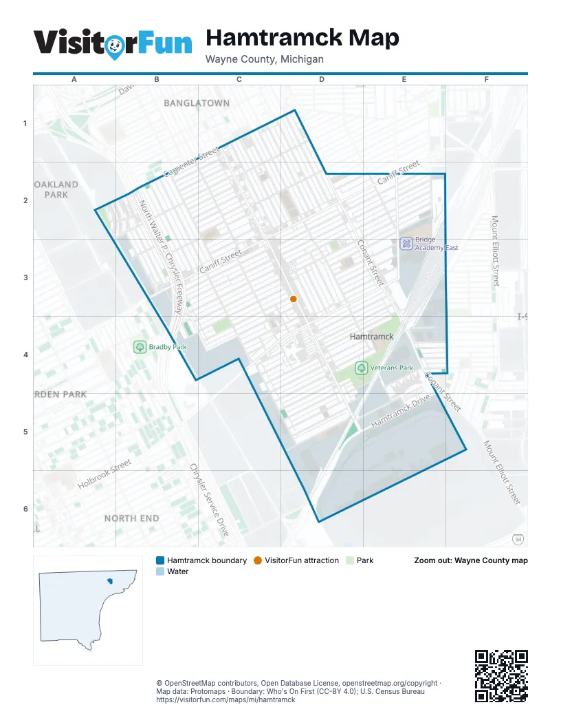
Street index of Hamtramck
Each street on the sheet and the grid squares it crosses.
- Carpenter StreetC1, A2, B2
- Charest StreetC1, C2, D2, D3
- Commor StreetC1, D1, B2, C2
- Gallagher StreetC1, D2, D3, D4, E4
- Joseph Campau StreetC1, C2, C3, D3, D4, D5
- Klinger StreetC1, D1, D2, E5
- Maine StreetC1
- McDougall StreetC1, C2, D2, D3, E4, E5
- Mitchell StreetC1, C2, D3, D4
- Neibel AvenueC1, B2, C2
- Shakir Khan Boulevard / Gallagher AvenueC1, C2, D2
- Sobieski StreetC1, D2
- Bristow StreetD1
- Conant StreetD1, D2, E3, E4
- Moran StreetD1, D2
- Circle DriveA2, B2
- Oklahoma StreetA2, B2
- Selfridge StreetA2, B2
- Botsford StreetB2, C2
- Dequindre StreetB2, B3, B4, C4
- Dyar StreetB2, B3, B4
- Fleming StreetB2, C2, C3
- Goddard StreetB2
- Grand Haven StreetB2, B3
- Lumpkin StreetB2, B3, C3, C4, C5, D5
- Mackay StreetB2, C2, C3
- Nagel AvenueB2, B3
- North Walter P. Chrysler FreewayB2, B3, B4
- Pulaski StreetB2, C2
- Saint Aubin StreetB2, B3, D6
- South Walter P. Chrysler FreewayB2
- Walter P. Chrysler FreewayB2, B3, B4
- Whalen StreetB2, C2
- Zinow StreetB2, C2
- Burger StreetC2, C3
- Caniff StreetC2, D2, E2, B3, C3
- Casmere AvenueC2, B3
- Casmere StreetC2, D2
- Holmes StreetC2, C3
- Belmont StreetD2, E2, B3, C3, D3
- Falcon AvenueD2, D3
- Harold StreetD2
- Prescott AvenueD2
- Prescott StreetD2
- Trowbridge StreetD2, E2, B3, C3, D3
- Yemans StreetD2, E2, B3, C3, D3
- Alpena AvenueE2
- Buffalo StreetE2, E3
- Edwin StreetE2, C3, D3, E3, B4, C4
- Ellery StreetE2
- Evaline StreetE2, C3, D3, B4
- Caniff Avenue EastB3
- Caniff Avenue WestB3
- Chrysler DriveB3, B4
- Chrysler Service DriveB3, B4
- Nagel StreetB3
- Woodland AvenueB3
- Brombach StreetC3, C4, D4
- Latham StreetC3, D4
- Norwalk StreetC3, D3, E3, C4
- Comstock StreetD3, E3
- Doremus StreetD3, E3
- Florian StreetD3, C4, D4
- Holbrook StreetD3, E3, C4, D4
- Lehman AvenueD3, E3, D4
- Poland StreetD3, C4
- Winfield StreetD3
- Golden Gates AvenueE3
- Hanley AvenueE3, D4
- Jacob AvenueE3, D4, E4
- Vincent StreetF3, F4
- Bernard StreetC4
- Dubois StreetC4
- Faber AvenueC4, D4
- Geimer StreetC4, D4
- Hewitt AvenueC4, D4
- Wyandotte StreetC4, D4
- Andrus AvenueD4, D5
- Berres StreetD4
- Brombach Street (Henry Ford Entrance)D4
- Dan AvenueD4, E4, D5
- Danforth AvenueD4, C5, D5
- Goodson AvenueD4, E4, C5, D5
- Henry Ford HamtramckD4
- Roosevelt AvenueD4, E4
- Christopher AvenueE4
- Dorothy AvenueE4, F4
- Goodson StreetE4
- Manuel StreetE4
- Miller StreetE4, F4
- Missant StreetE4, E5
- Oliver AvenueE4
- Roosevelt StreetE4
- Vincent AvenueE4, F4
- Dodge StreetF4
- Alice AvenueD5
- Council StreetD5
- Denton AvenueD5, E5
- Denton StreetD5, E5
- East Saint Aubin BoulevardD5
- Grayling AvenueD5
- Hamtramck DriveD5, E5
- Craig StreetE5
- Marston StreetD6
Things to do on the Hamtramck map
Places on the map
- Al Haramain International Foods INC
- Al-Haramain International Foods
- Al-Islah Islamic Center
- Ant Hall
- Bank Suey
- Beth Olem Cemetery
- Bismillah Grocery
- Bozek's Market
- Bridge Academy East
- Buhay Chapel
- Caniff Liberty Academy
- Chemical Bank
- Corinthian Baptist Church
- CVS Pharmacy
- Dickinson East Elementary School
- Dickinson East Elementary School playground
- Dollar General
- Early Childhood Elementary School
- Fresh Valley Market
- Ghost Light
- Hamtown Farms
- Hamtramck Academy
- Hamtramck City Hall
- Hamtramck Fire Department
- Hamtramck High School
- Hamtramck Hotel & Hostel
- Hamtramck Post Office
- Hamtramck Public Library
- Hamtramck Stadium
- Hanley International Academy
- Henry Ford Medical Center - Hamtramck
- Holbrook Elementary School
- Huntington Bank
- Immaculate Conception Ukrainian Byzantine Catholic Church
- Islamic Center of Hamtramck
- Joseph Campau Historic District
- St. Florian Church
- Veterans Park
- William Dickerson Detention Facility
Next to Hamtramck
- Arden Park
- Banglatown
- North End
- Oakland Park
© OpenStreetMap contributors, Open Database License, openstreetmap.org/copyright · Map data: Protomaps · Boundary: Who's On First (CC-BY 4.0); U.S. Census Bureau















