

Mississippi map
Gulfport map
About 74,621 people live here (Census Bureau, 2024 estimate). The sheet's index lists 300 streets; 5th Street, Lorraine Road and Three Rivers Road cross the most grid squares. Things to do inside the boundary: Island View Casino Resort and Mississippi Aquarium.
Open the map (PDF, US Letter)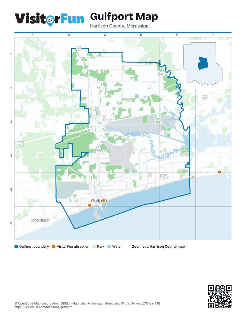
Street index of Gulfport
Each street on the sheet and the grid squares it crosses.
- East Beach BoulevardC5, D5, E5
- Lorraine RoadE2, D3, E3, D4, E4
- Tradition Scenic ParkwayE1, E2, E3
- 25th AvenueC4, C5
- West Beach BoulevardC5, B6, C6
- Pass RoadD4, E4, C5, D5
- Beach DriveD5, E5
- East Pass RoadD4, E4
- Cowan RoadE4, E5
- East Beach Boulevard / Beach DriveD5, E5
- State Highway 53B1
- Three Rivers RoadC1, D1, C2, C3, C4
- 28th StreetB5, C5, D5
- Dedeaux RoadC3, D3, E3
- Hewes AvenueD4, D5
- Courthouse RoadD3, D4, D5
- Airport RoadC4, D4
- Washington AvenueC3, D3, D4, E4, D5
- West Railroad StreetB5, C5, B6
- 30th AvenueC5, C6
- 15th StreetB5, C5
- Creosote RoadC3
- Crossroads ParkwayC3
- John Ross RoadD2, E2
- Canal RoadB4, B5
- Debuys RoadE4, E5
- Broad AvenueB5, B6
- Old Pass RoadB5, B6
- Seaway RoadC3, D3, E3
- Old Highway 49B1, B2, C2, C3, C4
- Oneal RoadC2, D2, E2
- South Swan RoadB1, C1
- East Railroad StreetB1, C5, D5
- 34th StreetB5, C5, D5
- 19th StreetB5, C5
- 34th AvenueC4, C5
- 22nd StreetB5, C5, D5
- 23rd AvenueC5, C6
- John Hill BoulevardC4
- Klein RoadC2, C3
- Duckworth RoadB1, C1
- Rippy RoadC3, D3, C4, D4
- 20th AvenueC5
- Texas AvenueC4, D5
- 13th StreetC2, B5, C5
- 17th StreetB5, C5, D5
- 33rd AvenueC5, C6
- 22nd AvenueC5
- Teagarden RoadD4, D5
- 42nd AvenueB5, B6
- Switzer RoadE4
- Anniston AvenueE4, E5
- Martin Luther King Jr BoulevardC4
- Gulf AvenueD5
- 38th AvenueB4, B5, B6
- Robinson RoadB2, C2
- Arkansas AvenueC4, D5
- 8th AvenueC4, C5
- Polk StreetC4
- Magnolia StreetE4
- Lewis AvenueB5, B6
- Orange Grove RoadB2, C2
- John Clark RoadB2
- Mill RoadD4
- South Railroad StreetB5, D5, B6
- 48th StreetD4
- Community RoadC3
- Pine StreetE4, D5
- North Swan RoadB1, C1
- West Pine StreetD4, E4
- Landon RoadC3
- Bridge StreetE4
- North Carolina AvenueC4
- Kahler StreetD4
- 62nd AvenueB5
- Riverten RoadC3
- Commission RoadB5
- East Old Pass RoadB6
- C T Switzer Senior DriveE4
- 11th StreetB5, C5, B6
- 20th StreetB5, C5
- 31st StreetB5, C5, D5
- 5th StreetB1, C2, E4, B5, D5, E5
- 29th StreetB5, C5, D5
- 24th StreetC5, D5
- 23rd StreetC5, D5
- 3rd StreetB1, E4, B5, C5, D5
- 30th StreetB5, C5, D5
- 2nd StreetB5, C5, D5
- 16th StreetB5, C5, D5
- 21st StreetB5, C5
- 9th StreetB5, C5
- 8th StreetB5, C5, B6, C6
- 7th StreetC2, B5
- Oak AvenueD4, D5
- 32nd StreetB5, C5, D5
- 33rd StreetB5, C5, D5
- Kendall AvenueD3, D4
- 26th StreetC5, D5
- 25th StreetC5, D5
- Jackson StreetD3, C4
- River RoadD1, E1, E2
- 43rd AvenueB5, B6
- 18th StreetB5, C5
- Depew RoadC2
- 10th StreetB5, C5, B6
- 24th AvenueC5
- 27th StreetC5, D5
- Collins BoulevardB1, C1, E5
- 32nd AvenueC5
- Bayou CircleD3
- 19th AvenueC5
- 31st AvenueC5
- 39th AvenueB4, B5, B6
- Parkwood Drive NorthC2
- Bonnie StreetD1, D2
- 41st AvenueB5, B6
- Park BoulevardB5, C5
- 14th StreetB5, C5
- Commerce StreetD4, E4
- Reichold RoadD3, E3
- North Wilson BoulevardC2, C3
- 44th AvenueB5
- Woodward AvenueB5, B6
- Chamberlain AvenueD4
- 26th AvenueC5
- Preservation DriveD2
- 18th AvenueC5
- Marvin Shields BoulevardB5
- Turtle Creek ParkwayD1, D2
- Colby AvenueB5
- JFM ParkwayB3
- John RoadD1, D2
- Glascock DriveD3
- Tandy DriveC2, D3
- Alphabet RoadD2
- Cuandet RoadC3, C4
- Madison StreetC4
- 35th StreetB4, C4, D4
- Ford StreetE4, B6
- Mays RoadC2
- Ohio AvenueC4
- Monroe StreetC4
- 13th AvenueC4, C5
- Hancock AvenueD4, D5
- 53rd AvenueB4, B5
- Bainbridge AvenueB5
- Rich AvenueB5, B6
- Mills AvenueB5, B6
- 45th StreetD4, B5
- Factory Shops BoulevardC3
- 47th StreetD4
- East AvenueD2, D4, C5, D5, E5
- Andy StreetD1, D2
- Holly CircleC4
- Dolphin LaneE3, E4
- 12th StreetB5, C5
- Curtis StreetD1, D2
- 1st StreetB5
- 6th AvenueD5
- 37th AvenueB4, B5, B6
- Mock StreetD1, D2
- 29th AvenueC5
- 36th AvenueB5, C5, C6
- 17th AvenueC5
- Kelly AvenueC5
- 5th AvenueB1, D5
- Finley StreetB6
- Palmer DriveE4
- Searle AvenueD4, D5
- Intraplex ParkwayD3, E3
- Van Buren StreetC4
- Trailwood DriveC2
- Camp AvenueB5, B6
- Jefferson StreetC4
- Latimer RoadD2, D3
- 37th StreetB4, C4, D4
- Cardinal DriveB4, C4, B5
- 40th AvenueB5, B6
- Louisiana AvenueC4
- Broadmoor PlaceC5
- Highland CircleE2
- East Taylor RoadE4
- Quail Ridge RoadB2
- Warren DriveC2, C3, D3
- Huntington CircleC1
- Gulfport Harbor StreetC5, C6
- South Carolina AvenueC4
- Franklin AvenueD3, D4
- Demaret DriveE4
- Fishermans TrailE2
- 45th AvenueB5
- 21st AvenueC5
- Lawson AvenueD3, D4
- Sheldon StreetE1, E2
- Church StreetB1, D4, E4
- Fournier AvenueB5, B6
- Boles BoulevardD1
- Wind Rose CircleC1, C2
- Darby StreetC2
- Willow Oak CircleD1, D2
- 54th StreetD3, D4
- East Railroad AvenueC4
- Indiana AvenueC4
- 53rd StreetD4
- Virginia AvenueC4
- Beau Forest DriveD2
- Carl Legett RoadE4
- Florida AvenueC4
- Fox Hill DriveC1
- Tennessee AvenueC4
- 52nd StreetD4
- 51st StreetD4
- Bullis AvenueC5
- Harrison StreetC4
- South Country Wood DriveC1
- Ganges StreetB4, C4
- 46th AvenueB5
- Falcon RoadD4
- Loveless DriveC2
- Eagle RoadD4
- Parkwood Drive SouthC2
- Hardy AvenueB5, B6
- 6th StreetC2, B5
- Reservation DriveC2, D2
- Carriage CircleC1, C2
- West Railroad AvenueC4
- Georgia AvenueC4
- Johnson DriveC5
- Sharp BoulevardD3
- Alabama AvenueC4
- Mississippi AvenueC4
- Harrison DriveB4, C4
- Autumn ChaseC2
- Holliman CircleD2
- George StreetD3
- Government StreetC2
- Evans RoadD3
- Saint Charles StreetC2
- Greenview DriveE4
- Ollie RoadE2
- Evans AvenueD5, E5
- Prudie CircleC2, D2
- Brentwood BoulevardE4
- Joseph AvenueB5, B6
- Shirley DriveC2
- Creel CircleE3, E4
- Gary StreetC3
- North StreetD2, E5
- Simpson RoadC2
- Tyler StreetC4
- Ruth AvenueB5, B6
- 54th AvenueB4, B5
- Oakwood DriveD5
- Holtman AvenueB5
- Roberts AvenueD5
- Beach AvenueB5, B6
- Hidden Oaks DriveD1
- South Wilson BoulevardC3
- Poplar CircleD4
- Silver Ridge AvenueD4, D5
- Curcor DriveE5
- Jefferson AvenueD4
- Tara Hills CircleC1
- Greenbriar DriveD4
- Riverroad DriveE2
- Pine Hills DriveD3
- Briarstone PlaceE4
- Gorman StreetD1, D2
- Williams RoadD2
- Fastway LaneC3, D3
- Venetian GardensE5
- South Vista DriveD3, D4
- Township RoadD5, E5
- Barbara DriveC2
- Victory StreetD5
- Harmony CircleC2
- McKinney AvenueB5
- Corporate DriveD3
- Saint James BoulevardE5
- Ann AvenueD1, D2
- 14th AvenueC5
- 15th AvenueC5
- 16th AvenueC5
- Southern CircleE5
- 55th AvenueB5
- Middlecoff DriveE4
- Lavelle DriveC2
- Camille CourtB5, C5
- Greenwood AvenueB5
- Goodier AvenueB5
- 56th AvenueB5
- Larkin I Smith DriveD3
- Herring RoadB2
- 3rd AvenueB1
- 43rd StreetD4
- Hatten LaneC1
- Quincy AvenueD3, D4
- Pine AvenueC5
- Plantation LaneE4
Things to do on the Gulfport map
Places on the map
- 28th Street Park
- 34th Street Community Garden
- Altitude
- Applebee's
- At Home
- Bayou Bluff Tennis Club
- Bayou View Park
- Beach Boulevard Steamer
- Bel Aire Elementary School
- Best Buy
- Best Western Plus Seaway Inn
- Blow Fly Inn
- Bruce Ladner Memorial Park
- Centennial Plaza
- Coley Island
- Crossroads Elementary School
- Crossroads Shopping Center
- Evergreen Garden Cemetery
- FedEx Shipping Center
- Floral Hills Memorial Gardens
- Great Southern Golf Club
- Gulf Islands Water Park
- Gulfport City Hall
- Gulfport High School
- Gulfport Premium Outlets
- Gulfport-Biloxi International Airport
- Gulfport-Harrison County Library
- Island View Casino Resort
- Jones Memorial Park
- Klumb Lumber
- KOA Holiday
- Lyman Elementary School
- Memorial Hospital Gulfport
- Mississippi Aquarium
- Naval Construction Battalion Center Gulfport
- Newman Lumber
- Pass Road Elementary School
- Singing River Gulfport
- Three Rivers Elementary
- Three Rivers Park
Next to Gulfport
- Long Beach
© OpenStreetMap contributors, Open Database License, openstreetmap.org/copyright · Map data: Protomaps · Boundary: Who's On First (CC-BY 4.0); Quattroshapes (CC BY 2.0)