

Mississippi map
Jackson County map
About 147,002 people live here (Census Bureau, 2024 estimate). The sheet's index lists 300 streets; State Highway 613, Martin Bluff Road and Washington Avenue cross the most grid squares. Things to do inside the boundary: Gulf Islands National Seashore.
Open the map (PDF, US Letter)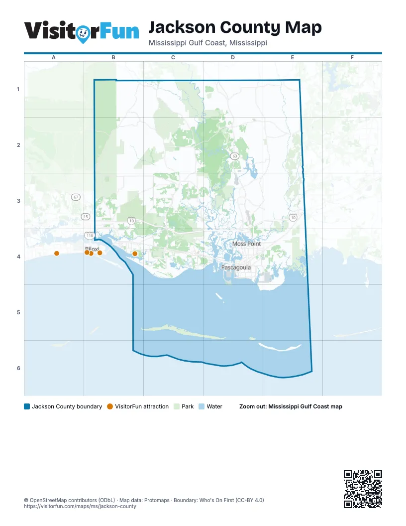
Street index of Jackson County
Each street on the sheet and the grid squares it crosses.
- Bienville BoulevardB4, C4
- Gautier Vancleave RoadC3, C4
- Washington AvenueB3, B4, D4
- Mississippi Highway 57C4
- Denny AvenueB4, D4
- Industrial RoadD4, E4
- Main StreetC4, D4
- Franklin Creek RoadE3
- Old Americus RoadD1
- Service DriveD4
- Telephone RoadD4
- Biloxi Bay BridgeB4
- Highway 90D4
- Frederic StreetD4
- Swing Gate Road CentralC2, C3
- Old Saracennia RoadD3
- Government BoulevardE3
- Old Biloxi RoadB1, B2, B3
- State Highway 613D1, E1, E2, D3, E3
- Old River RoadC1, C2, C3
- Jim Ramsey RoadB3, C3
- Seaman RoadB3, C3
- Wire RoadB1, B2, C2
- Airport BoulevardD2, E2
- Wade-Vancleave RoadC2, D2
- Old Spanish TrailC4, D4
- Saracennia RoadD3, E3
- Tanner Williams RoadD1, E1
- Old Stage RoadE3, E4
- Forts Lake RoadE3
- Ocean Springs RoadC3, B4, C4
- Market StreetD4
- Old Mobile AvenueD4, E4
- Government StreetB4, C4
- Tucker RoadB3
- Poticaw Bayou RoadC3, D3
- Polktown RoadD1
- O Neal RoadB2
- Vestry RoadB1, C1
- River RoadE1, D3, D4
- Coda RoadD3, E3
- Grierson StreetD4, E4
- Joe Batt RoadB3
- Wildwood RoadD3
- Ingalls AvenueD4
- Shortcut RoadD4, E4
- Lemoyne BoulevardB3, B4
- Davis Sawmill RoadD1
- Chicot StreetD4
- Independence RoadE3
- Red Creek RoadB1, C1
- Martin Luther King BoulevardD4
- Bayou Casotte ParkwayD4
- Lucedale RoadE1, D3
- Elder StreetD4
- Orchard RoadB3, B4, D4
- Tanner Chapel RoadE1
- Jerry Saint Pe HighwayD4
- CC RoadB2
- Jerry St Pe HighwayD4
- Old Biloxi Road WestB2
- Jim Ramsay Road CentralB3
- Wildwood Road EastD3
- C C RoadB2
- Ellis Hamilton Road EastD1
- Larue RoadB2, B3
- Old Fort Bayou RoadB3, C3, B4
- State Line RoadE1, E2
- Big Point RoadD2, E2
- Martin Bluff RoadC3, D3, C4, D4
- Paige Bayou RoadC3
- Elder Ferry RoadD3, D4
- Dolphin DriveC4
- Bayou Cumbest RoadE4
- Graveline RoadC4, D4
- Magnolia StreetB4, C4, D4
- White RoadC1, C2
- Daisy Vestry RoadB3
- Pointe Aux Chenes RoadB4, C4
- Big Ridge RoadB3
- Frank Snell RoadE2
- Mount Pleasant RoadC2, C3
- Beach BoulevardC4, D4
- Johns Bayou RoadC3
- Pascagoula StreetD4
- Fountainbleau RoadC4
- USS Vicksburg WayD4
- Humphrey RoadC3
- Jefferson AvenueD4
- Mallett RoadB3
- Beachview DriveC4
- Frederick StreetD4, E4
- 14th StreetD4
- Belair StreetD4
- Jackson AvenueB4, D4
- Ladnier RoadC4
- Oak StreetB3, C4, D4
- Quave RoadC3, B4
- Martin StreetD4
- Griffin StreetD4
- Dantzler AvenueD4
- Live Oak AvenueC4, D4
- Bechtel BoulevardB4
- West Frontage RoadC4, D4
- 2nd StreetD4
- Convent AvenueD4
- Macphelah RoadD4
- Holcomb BoulevardB4
- Bellview AvenueD4
- De la Pointe DriveD4
- Porter AvenueB4
- Halstead RoadB4
- Eden StreetD4
- Riley RoadC4
- Belle Fontaine RoadC4
- Ferry Point RoadC3
- Dutch Bayou RoadD4
- Frank Griffin RoadD3, D4
- Front Beach DriveB4
- Wilson Springs RoadD3
- Rose Farm RoadB3, B4
- Hospital StreetD4
- East Beach DriveB4
- Louise StreetD4
- Greyhound WayC4
- Kreole AvenueE4
- Valley Forge RoadE3
- Service RoadD3, D4
- Nathan Hale AvenueD4
- Dupont AvenueD4
- Canal StreetC4, D4
- Hanshaw RoadC4
- Fairway DriveC3, D3, B4
- Dr. Martin Luther King BoulevardD4, E4
- Brittany AvenueB4
- Krebs AvenueD4
- Salem Campground RoadD1
- Mc Innis AvenueD4
- Church StreetB4, D4
- Canty StreetD4
- Lake AvenueD4
- General Pershing AvenueB4
- Desoto StreetB4, D4
- Shearwater DriveB4
- Davidson RoadB4
- Cedar StreetD4
- Sherlawn DriveD4
- Greenwich AvenueD4
- Veterans BoulevardD4
- McCann RoadB3
- Race Track RoadB4
- Calhoun StreetB4
- Temple StreetD4
- Gorenflo RoadB3
- Delmas AvenueD4
- Doctor Martin Luther King DriveD4
- Port RoadD4
- Amoco DriveD4
- Chester Cunningham RoadE1
- NOAAD4
- Watts AvenueD4
- Johnson Still RoadB3
- Arthur StreetD4
- Cypress AvenueB3, D4
- Singing River IslandD4
- Laurel AvenueD4
- Morgan AvenueD4
- Post Office AvenueD4
- Big Point Road EastD2
- Hollis LaneD4
- Ponce de Leon WestB4
- Goren Flo AvenueB3
- Coyt Brooks RoadD1
- State Line Road EastE1
- Fort Lake RoadE3
- Lily Orchard RoadE2, E3
- John Smith RoadB2, B3
- McGregor RoadC2, C3
- Busby RoadC2
- Pollock Ferry RoadE3, E4
- Wolf Ridge RoadD2, D3
- Hurley Wade RoadD2, E2
- Bayou Heron RoadE3, E4
- Nutbank RoadD3, E3
- Ramie Farm RoadE1
- Campground RoadE1, C2
- Old Shell Landing RoadC4
- Schoolhouse RoadC1
- Orange Grove RoadD4, E4
- Old River Road LoopC2
- Bilbo RoadC1
- Antioch RoadB3, C3
- Belle Fountain DriveC4
- Red Bluff RoadC1, E1
- Hinton RoadE1
- Ridgeland RoadB3, C3
- Woodlake LaneB3, C3, C4
- Greenfields RoadE3
- Rayford Shumock RoadE2
- Goff Farm RoadE2
- Constitution RoadE2, E3
- Orso RoadE1
- Cedar Creek Estate RoadC1, D1
- Gregory StreetD4, E4
- Sammie Hearndon RoadD1, D2
- Shore DriveB3, B4
- Jordan RoadB3
- Pine StreetC4, D4
- Ellis Hamilton RoadD1, D2
- Summerlin Bayou RoadC3, D3
- Community DriveC4
- Coleman Homestead RoadE2
- Kings RoadD3, E3
- Shattles RoadD2
- McClellan RoadB3
- Old CCC Camp RoadC4
- Groveland RoadB4, C4
- Pipeline RoadD2
- Beach StreetC4
- Eglin RoadB3, B4
- Walker RoadB3
- Farm RoadC2
- Jackson County Line RoadE1
- Lakeview DriveC4, D4
- Baria RoadE2
- Soley RoadD1
- Glendale RoadB3
- School Land RoadB3
- Sims Mill Pond RoadC1
- Allie Byrd RoadB3
- Yellow Bluff RoadE1
- Gum StreetB3, C4
- Tantallon DriveC4
- Scarborough RoadB2
- John Holder RoadE1, E2
- Dwyer Branch RoadC2
- Kenneth Cole RoadC3
- Brown RoadC4
- 3C RoadC2
- Gulf Island National Seashore ParkwayB4
- Fox Ridge DriveB3
- Ware Lake RoadC3, D3
- Pascagoula River RoadD2
- Rosedale Church RoadD1
- Center StreetC4
- Mongers RoadC2
- South Double Still RoadB2
- Gavin Hamilton RoadD1, E1
- Ash StreetB3, C4
- Juniper DriveC2
- Indian Fork RoadB2
- Shelby LaneC4
- Semmes RoadC3
- Biddix-Evans RoadC4
- Martin AvenueB3, B4, E4
- Bienville Boulevard Service RoadB4, C4
- Grand Bature RoadE4
- Cedar Creek RoadD1
- West Spring Lake DriveC2
- Otis Cooper RoadE2
- Indian Point ParkwayC4, D4
- Poticaw Landing RoadD3
- Wesley Powell RoadD1
- Lake Forrest DriveB3
- Larry Carter RoadD2
- Sycamore StreetC4, D4
- Presleys Outing RoadE3
- Pine RoadD1, B4
- Rouses Marina RoadC3
- Foxrun DriveB3
- St Andrews DriveC4
- Shell Landing BoulevardC4
- 11th StreetD4
- Lampkin RoadD2, D3
- Tanner StreetC3, D4
- Meadowglen RoadB3, C3
- Yellow Jacket RoadB3, B4
- Hastings RoadC3, D3
- Pinehurst DriveC4
- North StreetB4, C4
- Cook RoadB3
- Parker RoadB3
- Willow StreetC4, D4, E4
- Allen RoadC3, C4
- Indian LaneC2
- Navaho RoadC4, D4
- Krohn RoadB3
- Carraway RoadD1, E1
- Beasley RoadC4
- Pine Grove RoadC3
- Roberts RoadC2, D3
- Westgate ParkwayC4
- Bayou Talla RoadB4
- Brodnax RoadB3
- Morningside DriveC3
- Good Hope StreetD4
- Sanctuary BoulevardB4, C4
- Community StreetD4
- Section RoadE1
- Wooded Acres RoadC3
Things to do on the Jackson County map
Places on the map
- Bangs Lake
- Bayou Porteaux
- Bear Bayou
- Beardsleee Lake
- Big Point
- Black Creek Cooling Pond
- Black Creek Swamp
- Bluff Creek
- Catch-Um-All Bayou
- Cedar Point Site
- Dad's Lake
- East Central County Park
- Escatawpa
- Fishing Bayou
- Gautier
- Grand Bay National Wildlife Refuge
- Graveline Bay
- Gulf Hills
- Gulf Islands National Seashore
- Gulf Park Estates
- Helena
- Hurley
- Kirkwood Lake
- Latimer
- Long Bayou
- Marsh Lake
- Mary Walker Bayou
- McInnis Bayou
- Mississippi Sandhill Crane National Wildlife Refuge
- Moon Lake
- Moss Point
- Naval Station Pascagoula
- O Pines Lake
- Ocean Springs
- Pascagoula
- Pascagoula Phosphate Mine
- Rabbit Island
- Saint Andrews Golf Club
- Saint Martin
- Ward Bayou Wildlife Management Area
Next to Jackson County
- Biloxi
- D'Iberville
© OpenStreetMap contributors, Open Database License, openstreetmap.org/copyright · Map data: Protomaps · Boundary: Who's On First (CC-BY 4.0); Quattroshapes (CC BY 2.0)