

Mississippi map
Lafayette County map
About 59,843 people live here (Census Bureau, 2024 estimate). The sheet's index lists 300 streets; County Road 244, Mississippi Highway 30 and County Road 202 cross the most grid squares. Things to do inside the boundary: Rowan Oak.
Open the map (PDF, US Letter)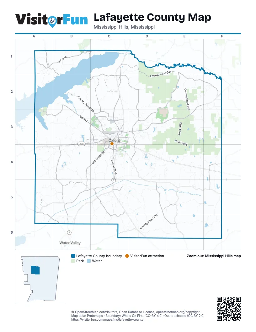
Street index of Lafayette County
Each street on the sheet and the grid squares it crosses.
- Mississippi Highway 30E2, F2, C3, D3, E3
- State Highway 6B3, C3, B4
- Mississippi Highway 328B5, C5
- MS 310A1, B1
- Mississippi Highway 315A5, A6, B6
- University AvenueC3
- Jackson Avenue WestC3
- Molly Barr RoadC3
- County Road 287F4
- Highway 30 EastC3
- West Jackson AvenueC3
- Jackson Avenue EastC3
- South 9th StreetC3, C4
- County Road 2020C3
- Toccopola RoadF5
- County Road 244C1, D1, E1, D2, E2, F2
- County Road 103C2, C3
- County Road 202E1, D2, E2, D3
- County Road 215C2, D2, D3
- Old Taylor RoadC3, B4, C4, B5
- County Road 445D5, D6, E6
- South Lamar BoulevardC3, C4
- County Road 101C2, C3
- County Road 313B4, B5
- Old Sardis RoadB2, B3, C3
- County Road 102B2, C3
- County Road 100B2, A3, B3
- Pleasant Ridge RoadC5, C6
- County Road 108C1, B2, C2, B6
- County Road 338B5
- College Hill RoadC3
- George G “Pat” Patterson ParkwayB3, C3
- Clear Creek RoadB4
- County Road 201C1, C2
- County Road 515A1
- County Road 166C3
- County Road 429F4, F5
- County Road 387B5, B6
- County Road 217D3, D4
- Sisk AvenueC3, D3
- Belk BoulevardC4
- County Road 436D5, E5
- County Road 104C3
- County Road 405D4
- County Road 517A1, B1, B2
- Anderson RoadB3, C3
- County Road 500B1, C1
- County Road 333B4, A5, B5
- County Road 420C5
- MS 314B3
- Park DriveC2, C3
- North Lamar BoulevardC3
- Golf Club RoadC3
- County Road 337C5
- County Road 1032C3
- Chucky Mullins DriveC3, C4
- County Road 371C5, C6
- County Road 178C3
- South 18th StreetC3, C4
- County Road 535B1, C1
- McElroy DriveC3
- North F.D. Buddy East ParkwayC3, D3
- South F.D. Buddy East ParkwayC4
- Gertrude Ford BoulevardC3
- East Jackson AvenueC3
- Bramlett BoulevardC3
- Washington AvenueC3
- East Long StreetC2
- West Oxford LoopC3
- West Long StreetC2
- Fraternity RowC3
- All American DriveC3
- Garfield AvenueC4
- Courthouse SquareC3
- Taylor RoadC3, C4
- Wyatte TyroA1
- County Road 162C3
- County Road 442E6, F6
- Lafayette Springs RoadF3, F4
- County Road 225D3, D4
- County Road 432D5
- County Road 428D6, E6
- County Road 444E5, F5
- County Road 245E2, E3
- County Road 343B4, B5
- Road 2066D3, E3, E4
- County Road 249E2
- County Road 105B3, B4
- County Road 450C5, D5
- County Road 317A4, B4
- County Road 210D2
- County Road 2066E3, E4, F4
- County Road 255F2, F3
- County Road 323C4, B5, C5
- County Road 430D5, D6
- County Road 325A4, B4, A5, B5
- County Road 471C5, D5
- County Road 204C2, D2, D3
- County Road 459F5, F6
- County Road 462F5, F6
- County Road 378C6
- County Road 424C5, D5, D6
- County Road 415D4
- County Road 277E3, E4
- County Road 425E4, E5
- County Road 107B3
- Road 2083E3
- County Road 403C4
- County Road 309B3, B4
- County Road 369C5, C6
- County Road 376C5, B6, C6
- County Road 418C4, D4
- County Road 367A5, B5
- Road 2064D2, E2
- County Road 141B2
- County Road 321C4, C5
- County Road 251E2, E3, F3
- County Road 208D2, D3
- County Road 421D4, E4, D5
- Road 2089E2, E3
- County Road 427E4, E5
- County Road 354A5
- County Road 461E4, E5
- County Road 431F4, F5
- County Road 386B6
- Bethel Ch RoadD4
- Peddler's Field CrossingB4
- Road 2085E3
- County Road 3019A4
- County Road 129C2
- County Road 291D1, D2
- County Road 352A5, B5
- County Road 250E3, F3
- County Road 379C6
- Liberty Hill RoadF3, F4
- New Hope RoadA1, A2
- County Road 246E2
- County Road 154A3, B3
- County Road 237D3, E3
- County Road 477D5, D6
- County Road 449E4, E5
- County Road 340B4, B5
- County Road 164A3, A4
- County Road 158B3
- County Road 235E2, D3, E3
- County Road 268E2, F2
- Anchorage RoadC3
- County Road 506B1
- County Road 247E3
- County Road 385C5, C6
- County Road 143B2, B3
- County Road 113A3
- County Road 423E4
- County Road 434D5, E5
- County Road 274E4, F4
- County Road 233D3, E3
- County Road 294C1, D1
- County Road 216E2
- County Road 361B4
- Highlands CircleD4
- County Road 311B4
- County Road 267E1, E2
- County Road 229D3
- County Road 413D4
- County Road 253F2
- County Road 327A4
- County Road 296C1, D1
- County Road 242E2, F2
- County Road 181C3
- County Road 374C5
- County Road 395A5, A6
- Corp of Engineers Svc RoadD2, E2
- Oxford WayC4
- County Road 316C4
- County Road 435D4
- County Road 1087A3, B3
- County Road 399A5
- County Road 342A4, B4
- County Road 452C5, D5
- County Road 3011B5, C5
- Road 2079D2
- County Road 381D6
- County Road 473C5, D5
- Woodland Hills DriveC3
- County Road 344A4
- West Wellsgate DriveB3
- County Road 111A3, A4
- Muccaloon RoadE5
- Childress RoadA1, A2
- County Road 207C3, D3
- County Road 511B1
- County Road 160B3
- County Road 469C5
- Downing StreetD3
- County Road 443D4, D5
- County Road 370C5
- Road 2087E3
- Road 2081D2
- County Road 422C5
- County Road 212D3
- County Road 518A1
- County Road 390B6
- County Road 479F5, D6
- Road 2090E2, E3
- County Road 319A4
- County Road 206D3
- County Road 433F4, F5
- East Wellsgate DriveB3
- Private Road 3151B3, B4
- County Road 475D5
- County Road 373C5
- County Road 493E6
- County Road 419D4, E4
- Thacker Heights DriveB3, B4
- County Road 411D4
- County Road 5009A1, A2
- Road 2075E3
- County Road 279E4
- County Road 231D3
- County Road 109B3, B4
- County Road 447D4, D5
- County Road 509B1
- Lyles DriveC4
- County Road 470D4, E4
- County Road 275E4
- Majestic Oaks DriveC4
- County Road 505B1
- Winners CircleA4
- County Road 332B4, C4, B5
- County Road 285E4
- Ed Perry BoulevardC3
- Shady Oaks CircleC4
- Lake DriveA1
- Timberlake DriveD3
- County Road 377B6
- County Road 358A5
- Lakes Drive SouthD4
- Fox Trail RunC3
- Buford Chapel RoadB3, C3
- County Road 259E2
- County Road 409D4
- County Road 252E3, F3
- Augusta DriveC4
- Chickasaw RoadC3
- County Road 284F4
- County Road 389B6
- County Road 383D6
- Road 3067C4
- Pea Ridge Farm RoadC4
- County Road 481D6
- County Road 273E4
- Fazio DriveC4
- Hathorn RoadC3
- County Road 308C4
- County Road 297D1
- County Road 437D4
- County Road 346B5
- Jefferson AvenueC3
- Pea Ridge RoadC4
- County Road 182B2
- Greenhaven DriveD3
- Country Club RoadC3
- County Road 382C6, D6
- Lake Drive NorthD4
- County Road 388B5
- County Road 139C2
- County Road 186B2
- County Road 5016B1
- County Road 345B4
- County Road 260F3
- County Road 243E2
- County Road 256F2
- County Road 523B1
- County Road 224D3
- County Road 198C3
- Murphy Rodge RoadA4
- County Road 3024C4
- Nottiingham DriveC4
- Student Union DriveC3
- Pine Flat RoadC5
- County Line RoadF5
- Ridgewood Manor DriveC3
- County Road 3005A5
- South 16th StreetC3, C4
- Quail Creek DriveC3
- Whitetail DriveC3
- County Road 380C6, D6
- Longmeadow DriveC3
- County Road 457E5
- Insight Park AvenueC3, C4
- County Road 2068D3
- Rebel DriveC3
- County Road 417D4
- C R 286D3
- St Andrews CircleC3
- County Road 349B5
- County Road 110C2
- County Road 362B4
- Yocona Ridge RoadC4
- County Road 468D4
Things to do on the Lafayette County map
Places on the map
- Abbeville
- Abbeville Post Office
- Avent Park
- Bailey Woods
- Baptist Memorial Hospital-North Mississippi
- Black Acre
- Braemar Park
- Bramlett Elementary School
- Bramlett Pond
- Cambridge Lake
- Carter Mountain
- Clear Creek Landing Public Use Area
- Coon Creek Lake
- Cypress Lake
- East Cypress Lake
- Emergency Room Entrance - BMH North Mississippi
- Hurricane Landing Public Use Area
- Jack McCormick Pond
- Lafayette County School System
- Lafayette Lake
- Lamar Park
- mTrade Park
- North Cypress Lake
- North Cypress Lake Recreation Area
- North Lake
- Oxford
- Oxford Sand Pit
- Puskus Lake
- Puskus Lake Recreation Area
- Russell Lake
- Sardis Lake
- Sardis Waterfowl Refuge
- South Campus Rail Trail Recreational Area
- South Lake
- State Veterans Home
- Taylor
- The Country Club of Oxford
- The Ole Miss Golf Course
- Timber Lake
- University of Mississippi
Next to Lafayette County
- Water Valley
© OpenStreetMap contributors, Open Database License, openstreetmap.org/copyright · Map data: Protomaps · Boundary: Who's On First (CC-BY 4.0); Quattroshapes (CC BY 2.0)