

Montana map
Park County map
About 18,074 people live here (Census Bureau, 2024 estimate). The sheet's index lists 300 streets; East River Road, Old Yellowstone Trail South and Shields River Road cross the most grid squares. Things to do inside the boundary: Roosevelt Arch, Flying Pig Adventure Company and Wild West Rafting.
Open the map (PDF, US Letter)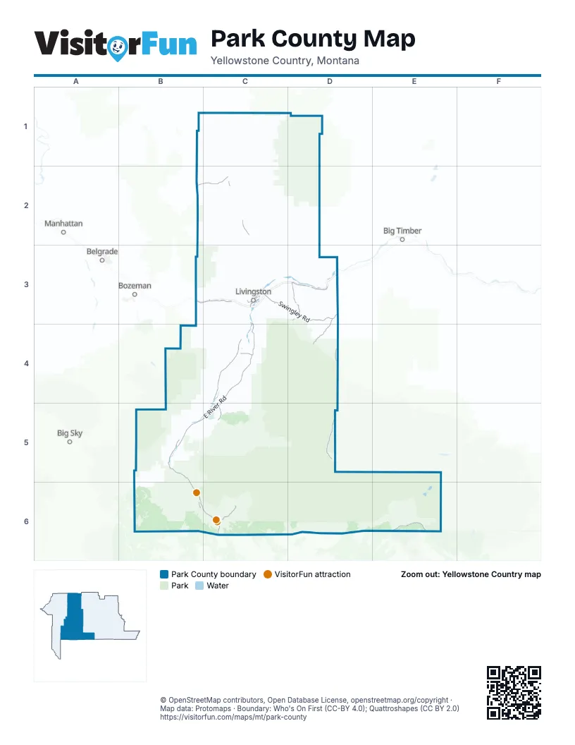
Street index of Park County
Each street on the sheet and the grid squares it crosses.
- US Hwy 89 SB6, C6
- US Highway 89 NorthC2
- West Park StreetC3
- East Park StreetC3
- Scott Street WestC6
- First Avenue NorthC2
- Park StreetC6
- Elliot Street SouthC2
- Elliot Street NorthC2
- North Elliot StreetC2
- First Avenue SouthC2
- South Elliot StreetC2
- Second Street SouthC6
- Veterans' BridgeC3
- Yellowstone River BridgeC6
- East River RoadC3, C4, B5, C5
- State Highway 86B2, C2
- Beartooth Scenic BywayE6
- US Highway 212E6
- Temporary North Entrance RoadC6
- Northeast Entrance RoadE6
- Murphy LaneC5
- North Entrance RoadC6
- North Main StreetC3
- East Main StreetE6
- South Main StreetC3
- West Main StreetE6
- Carbella BridgeB5
- Main Street BridgeC3
- Swingley RoadC3, D3
- Main Boulder RoadD4, D5
- Old Yellowstone Trail NorthC4
- Old Yellowstone Trail SouthB5, B6, C6
- Frontage RoadC3, D3
- Mission Creek RoadD3
- West Boulder RoadD3, D4
- Jardine RoadC6
- Frontage Road EastD3
- Chico RoadC5
- Old Yellowsstone Trail SouthB5
- Pine Creek RoadC4
- Bozeman Hill RoadB3, C3
- East Gallatin StreetC3
- West Front StreetC3
- View Vista DriveC3
- West Geyser StreetC3
- East Geyser StreetC3
- Boulder RoadD3, D5
- North 2nd StreetC3
- Star RoadC3
- North B StreetC3
- South 2nd StreetC3
- North C StreetC3
- South East StreetC3
- Bennett StreetC3
- South B StreetC3
- Sleeping Giant StreetC3
- Flynn Creek RoadC3
- US Highway 10 WestD3
- East Chinook StreetC3
- East Frontage RoadD3
- Shields River RoadC1, D1, C2
- Mill Creek RoadC4, C5, D5
- Convict Grade RoadC3, D3
- Trail Creek RoadB4, C4
- Rock Creek Road NorthC2
- Willow Creek RoadC3
- Tom Miner Creek RoadB5, B6
- Brackett Creek RoadB2, C2
- Cottonwood Bench RoadC2
- Lower Cottonwood RoadC2
- Horse Creek RoadC2
- Elk Creek RoadC1, C2
- Fleshman Creek RoadC3
- Castle Mountain RoadC2, C3
- Rock Creek Road SouthB5
- Six Mile Creek RoadB5, C5
- Ferry Creek TrailC3
- Eagle Creek RoadC6
- Adair Creek RoadC3, D3
- Porcupine RoadC1
- Dry Creek RoadB4, B5
- Daisy Dean RoadC1, C2
- Myers LaneC3
- Miller RoadC2
- Cokedale RoadC3
- Big Creek RoadB5
- Shields River Road EastC2, C3
- West Fork Mill Creek RoadC5
- O'Rea Creek RoadC3
- Old Clyde Park RoadC3
- Chicken Creek RoadC2
- Rockafellow RoadC2
- Hammond Creek RoadC2
- Dutch RoadC5
- Robinson Bench RoadC2, D2
- Livingston Peak RoadC3
- Upper Cottonwood Creek RoadC2, D2
- Grizzly Meadow RoadB5
- Divide RoadC4
- Bear Creek RoadC6
- Old Flathead Creek RoadB2, C2
- Cinnabar Basin RoadB6
- Muddy Creek RoadB2, C2
- Looking Glass Creek RoadC2
- West Pine Creek RoadB4, C4
- Old Boulder RoadC3
- Shy RoadC2
- Bright LaneC1
- Daily Lake RoadB5
- North Fork Willow Creek RoadC3
- Morgan TrailC4
- Quinn Creek RoadB3, C3
- Hercules RoadB5
- Middle Fork Horse Creek RoadC2
- Crevice RoadC6
- Mol Heron Creek RoadB6
- Coal Camp RoadC1
- Bruffey LaneD3
- Falls Creek RoadC2, C3
- Upper Cottonwood RoadC2
- Elk Creek Road WestC1
- Tobin Creek RoadC2, C3
- Chico Cemetery RoadC5
- Cole Creek RoadC1
- Indian Creek RoadC2
- Dry Creek Road SouthB5
- Lake Abundance RoadE6
- Canyon Creek RoadC2
- Strickland Creek RoadC4
- North Dry Creek RoadC4
- Enyart LaneC2
- North Fork Horse Creek RoadC2
- Capricorn DriveC4, B5, C5
- Meigs RoadC3
- Woods LaneC2
- McGuire Hill RoadC4
- Kister Hardy RoadB2
- Eight Mile Creek RoadC4
- Luccock Park RoadC4
- Wineglass RoadC3
- Conlin RoadC5
- North Fork Elk Creek RoadC1
- Merideth Ranch RoadC3
- Bennett Creek RoadC1, D1
- Rendezvous TrailC3
- Above Paradise TrailC3, C4
- Ibex RoadC2
- Suce Creek RoadC4
- Jackson CreekB3
- Elk Creek Road NorthC1
- Smith Creek RoadC1
- Deep Creek RoadC4
- Forest Route 3272C5
- Elk Creek Road SouthC1
- Eldridge Creek TrailB3, C3
- OTO Ranch RoadB5, B6
- Sunlight Creek RoadC1
- Emigrant Creek RoadC5
- Mountain Brook RoadB3
- Meeker RoadB2, C2
- Clark LaneC4
- Elk Ridge RoadB3, C3
- Shields LaneC2
- East Fork Mill Creek RoadC5
- Sagittarius SkywayB5
- Bangtail Ridge RoadC3
- Old North Entrance Road (Closed)C6
- Wineglass Loop NorthC3
- Queen LaneC2
- Gilbert RoadC2
- Infinity Mountain TrailB4
- Curlew TrailC3
- Lower Cottonwood Road EastC2
- Pray RoadC4
- Wall Rock RoadC1
- Alpine Springs LaneB3
- Fiddle Creek RoadC3
- Anderson RoadC1
- Heritage TrailC3
- Travertine RoadC6
- O'Halloran RoadC2
- Pleasant View RoadC2
- Highland RoadD4
- Majestic Ridge TrailC4
- Buffalo TrailC3
- Big Mac AB3
- Hunters Hot Springs RoadD3
- Newman RoadB4
- Moose MeadowsB3, C3
- FS 650B6
- Whitetail ButteC3
- Red Quarry BC6
- Airport RoadC3, C6
- Lake Drive EastC3
- West Grannis RoadC3
- Inverness RoadC4
- Chicory RoadC4
- Arcturus DriveB5
- Laubscher & Bodine RoadC2
- Chapel RoadC2
- O'Halloran Road WestC2
- Deep Creek South Fork RoadC4
- Bridger Hollow RoadC5
- South Fork Elk Creek RoadC1
- Fox RunC3
- Wineglass Loop SouthC3
- Rocky Mountain MeadowsB3
- Hideaway TrailC3
- Rock Creek RoadC2
- Bannock TrailE6
- Suce Creek Trailhead RoadC4
- Horse Creek Road SouthC2
- Daisy Pass Trail RoadE6
- FS 976C4
- Oregon Valley RoadD3
- Fridley Creek RoadB5, C5
- Yellowstone Street West Creek BranchB5
- Indian Hill RoadC4
- Mission Meadow RoadD3
- Rock Top PassC3
- Nelsons Spring Creek RoadC4
- Rocky Creek LaneC2
- Spring Creek Hills RoadC4
- Jumping Rainbow RoadC4
- Above Paradise LoopC3, C4
- Loch Leven RoadC4
- Meridian RoadC4
- Redtail RoadC3
- O'Hair LaneC4
- River DriveC3, C4
- Sirius DriveC5
- Pepper LaneC1
- Old Yellowstone Trail North RoadC4
- Caledonia RoadC4
- Shooting Star TrailB6
- Mather LaneC2
- Beyond Paradise TrailC4
- Pronghorn TrailC3
- Morrison LaneC2
- Runway LaneC4
- Broken WheelC3
- Little Spring Creek RoadC3
- Dexter Peak RoadC4
- Prairie Dog RoadC3
- Antelope FlatsC3
- Lulu Pass Trail RoadE6
- East Lewis StreetC3
- Gunsmoke RoadD3
- Story RoadC5
- Peak View TrailB5
- East Callender StreetC3
- West Clark StreetC2, C3
- Dry Creek Road NorthC1
- Duck Creed RoadD3
- Miller DriveC3
- River Road NorthD3
- Elbow Creek RoadC4
- Lake DriveC3
- Billman LaneC3
- Sheep Mountain RoadD3
- Deep Creek Bench RoadC4
- Sawmill RoadE6
- Cowboy Lake RoadC5
- Duck Creek RoadD3
- Great Escape RoadB2
- Harms LaneC3
- Lee LaneC2
- West Montana StreetC3
- Alpine Meadow TrailC3
- Leo DriveB5
- Kindsfather DriveC3
- Bridger Meadows LaneB5
- Mountain View RoadC3
- Rattlesnake RoadD3
- Woodchuck RoadB3
- George Creek RoadC4
- Reservoir RoadB2
- Waltons LaneC1
- Willow DriveC3
- Horse Thief TrailC3
- Crazy Head RoadC3
- Gateway DriveC3
- Pony RoadC3
- Wineglass Loop WestC3
- Plenty Coups TrailC4
- Big MacB3
- Shamrock LaneC3
- Cedar Bluffs RoadC3
- Frelich LaneC4
- Canyon View DriveC3
- Wineglass Loop EastC3
- Rustad LaneC3
- Hill RoadC1
- Paradise DriveC3
- Renaissance Ranch RoadC4
- Perkins LaneC2
- Aquarius LaneC4
- Mountain Springs LaneB3
- Gemini RoadB4, C4, C5
Things to do on the Park County map
Places on the map
- Aldridge Lake
- BLM
- Broadwater Lake
- Campfire Lake
- Christikon
- Clyde Park
- Cooke City
- Courthouse Lake
- Custer Gallatin National Forest
- Dailey Lake
- Dome Mountain Wildlife Management Area
- Emigrant
- Fizzle Lake
- Fox Lake
- Gardiner
- Goose Lake
- Granite Peak
- Grasshopper Glacier
- Hellroaring Meadows
- Hyalite-Porcupine-Buffalo Horn Wilderness Study Area
- Kaufman Lake
- Kersey Lake
- Lady of the Lake
- Livingston
- Lower Aero Lake
- Merrell Lake
- Mission Field
- Pear Lake
- Pruitt Park
- Rock Island Lake
- Rock Lake
- Rough Lake
- Sage Lodge
- Silver Gate
- Silver Tip Ranch
- Sky Top Lakes
- Sodalite Lake
- Upper Aero Lake
- Wilsall
- Wolf Glacier
Next to Park County
- Belgrade map
- Big Sky
- Big Timber
- Bozeman map
- Manhattan
© OpenStreetMap contributors, Open Database License, openstreetmap.org/copyright · Map data: Protomaps · Boundary: Who's On First (CC-BY 4.0); Quattroshapes (CC BY 2.0)















