

Nebraska map
Kearney map
About 34,741 people live here (Census Bureau, 2024 estimate). The sheet's index lists 300 streets; 2nd Avenue, Avenue M and 4th Avenue cross the most grid squares. Things to do inside the boundary: Great Platte River Road Archway Monument, Museum of Nebraska Art and Visit Kearney.
Open the map (PDF, US Letter)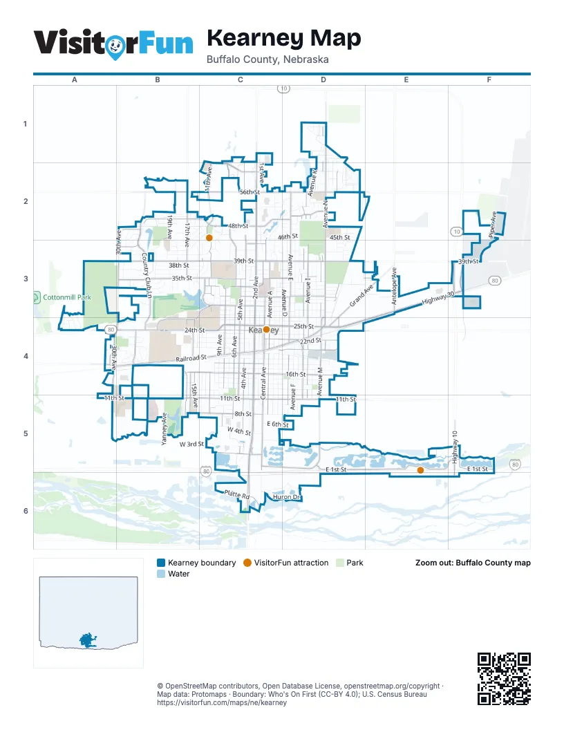
Street index of Kearney
Each street on the sheet and the grid squares it crosses.
- East 25th StreetE3, C4, D4, E4
- West 24th StreetA4, B4, C4
- Highway 30E3, F3, A4
- East 39th StreetC3, D3, F3
- Highway 10F3, F5, F6
- Cherry AvenueF2, F3, F5
- West 25th StreetC4
- 2nd AvenueC1, C2, C3, C4, C5, C6
- Avenue ND1, D2, D3, D4
- North Railroad StreetA4, B4, C4, D4
- 30th AvenueB3, A4, B4, A5
- Avenue MD1, D2, D3, D4, D5
- West 39th StreetB3, C3
- West 11th StreetA5, B5, C5
- 17th AvenueB2, B3, B4, B5
- West 56th StreetB2, C2
- East 11th StreetC5, D5
- East 56th StreetC2, D2
- South 2nd AvenueC6
- Antelope AvenueE3
- 30th RoadA4
- East Railroad StreetD4
- East 1st StreetC5, D5, E5, F5
- 4th AvenueC1, C2, C3, C4, C5
- Central AvenueC2, C3, C4, C5
- 11th AvenueC1, C2, C3, C4, C5
- Avenue ED2, D3, D4, D5
- 6th AvenueC2, C3, C4, C5
- Country Club LaneB2, B3, B4
- Avenue ID2, D3, D4, D5
- Avenue AC3, C4, C5
- Avenue HD2, D3, D4, D5
- West 35th StreetB3, C3
- 5th AvenueC3, C4, C5
- 8th AvenueC3, C4, C5
- 15th AvenueB2, B4, B5
- Grand AvenueD3, E3, D4
- East 16th StreetC4, D4
- West 48th StreetB2, C2
- West 16th StreetB4, C4
- West 8th StreetB5, C5
- East 22nd StreetC4, D4
- East 48th StreetC2, D2
- East 31st StreetC3, D3
- University DriveB3, C3, B4
- West 50th StreetB2, C2
- Spruce Hollow BoulevardC1, C2
- East 20th StreetC4, D4
- West 18th StreetA4, C4
- West 29th StreetC3
- Avenue QD2, D3, D4
- West 33rd StreetC3
- Platte RoadC6
- West 44th StreetB2, B3, C3
- 16th AvenueB4, B5
- East 35th StreetC3, D3, E3
- West 31st StreetC3
- West Talmadge StreetC5
- Lakeview DriveC3
- Plaza BoulevardB4
- West 60th StreetC2
- Coal Chute RoadD4
- Talmadge StreetC5
- 3rd AvenueC2, C3, C4, C5
- Avenue GD2, D3, D4, D5
- 1st AvenueC2, C3, C4, C5
- Avenue FD2, D3, D4, D5
- Avenue DD3, D4, C5, D5
- Avenue KD1, D2, D3, D4, D5
- Avenue CC3, C4, C5
- 9th AvenueC2, C3, C4, C5
- Avenue BC3, C4, C5
- 7th AvenueC3, C4
- 10th AvenueC2, C3, C4, C5
- Avenue LD1, D2, D3, D4
- 19th AvenueB2, B3, B4
- East 34th StreetC3, D3, E3
- West 37th StreetB3, C3
- 13th AvenueC3, C4, C5
- West 21st StreetB4, C4
- 14th AvenueC2, B3, C3, B4, B5
- West 22nd StreetB4, C4
- South Railroad StreetC4, D4
- 12th AvenueC3, C4, C5
- West 42nd StreetB2, B3, C3
- East 32nd StreetC3, D3, E3
- East 17th StreetC4, D4
- West 13th StreetB4, C4
- 20th AvenueB2, B3
- Linden DriveD2, D3
- East 28th StreetC3, D3
- East 1st Street SouthD5, D6, E6, F6
- East 30th StreetC3, D3
- West 38th StreetB3, C3
- Avenue RD2, D3
- West 23rd StreetB4, C4
- West 19th StreetC4
- East 18th StreetC4, D4
- East 15th StreetC4, D4
- West 14th StreetB4, C4
- East 13th StreetC4, D4
- West 20th StreetB4, C4
- 22nd AvenueB2, B3, B5
- East 26th StreetC4, D4
- East 33rd StreetC3, D3
- Parklane DriveC2
- West 28th StreetC3
- 27th StreetD3, D4
- West 27th StreetC3
- East 23rd StreetC4, D4
- West 36th StreetB3, C3
- West 17th StreetC4
- Eastbrook DriveD2
- West 4th StreetC5
- Avenue PD1, D2, D3, D4
- West 26th StreetC4
- East 52nd StreetC2, D2
- East 21st StreetC4, D4
- West 40th StreetB3, C3
- 28th AvenueB2, B3
- Meadow LaneB4
- Yanney AvenueB5
- West 15th StreetC4
- East 19th StreetC4, D4
- West 30th StreetC3
- East 8th StreetC5, D5
- East 14th StreetC4, D4
- Huron DriveC6, D6
- 29th AvenueB2, B3
- East 36th StreetC3, D3, E3
- East 2nd AvenueC5
- Fairacres RoadB2, B3
- East 42nd StreetD3
- Piper AvenueF2, F3
- South Central AvenueC6
- East 46th StreetC2, D2
- 2nd Avenue WestC1, C2
- Tahoe DriveC6, D6
- East 37th StreetC3, D3, E3
- East 6th StreetC5, D5
- Avenue SD2, D3
- East Landen StreetC5, D5
- East 45th StreetD2
- West 12th StreetC4, C5
- Pony Express RoadC2, C3
- Eastbrooke DriveD2
- Palamino RoadC2, B3
- West 52nd StreetC2
- Rolling Hills RoadA3, A4
- 63rd Street EastD1
- East 30th DriveD3
- East 44th StreetD3
- Avenue OD2, D4
- East 27th StreetC3, D3
- East 24th StreetC4, D4
- East 29th StreetC3, D3
- Red Fox LaneA3, A4
- 31st StreetB3
- Hillcrest DriveC3
- Skyline DriveC3
- West 3rd StreetC5
- West 41st StreetB3, C3
- Camelot WayB3
- East 69th StreetD1
- Laplatte RoadB4
- 1st Avenue PlaceC2, C3, C5
- Loveland DriveB2, C2
- West 47th StreetB2, B3
- East 33rd DriveD3
- West 46th StreetC2
- Remington DriveD1
- La Crosse DriveA4, B4
- University VillageB4
- La Vista RoadB4
- Villa DriveB4
- West 49th StreetB2
- Sunset TrailB2, B3
- Mustang TrailA4
- 16th StreetA4, B4
- East 65th Street PlaceD1
- Lake Side DriveA3, A4
- Avenue O PlaceD1, D2
- East 47th StreetD2
- Airport RoadF2
- East 51st StreetD2
- East 59th StreetD2
- East 58th StreetD2
- West 47th Street PlaceB2, C2
- West 43rd Street PlaceB3
- West 46th Street PlaceB2, B3
- West 36th Street PlaceB3
- Indian RoadD3
- East 10th StreetC5, D5
- 2804 West 35th StreetB3
- West 32nd StreetC3
- Kingwood CircleD2
- East 38th StreetD3, E3
- Kings CourtB3
- South 2nd Avenue WestC6
- Avenue UD2
- West 51st StreetB2
- Avenue L PlaceD1, D2
- Bel Air DriveC3
- Fairway AvenueB3
- Emerald DriveD6
- X AvenueE3
- Century PlaceC3
- Glenwood RoadB2, C2
- Aeronca StreetF2, F3
- 17th Avenue PlaceB3
- West 10th StreetC5
- East 62nd StreetD2
- West 61st StreetC2
- West 34th Street PlaceB3
- 10th Avenue PlaceC2
- Prairie View PlaceB2
- Tower Hill RoadB3, B4
- West 43rd StreetB3
- Winnipeg RoadD6
- V AvenueD3
- North Lake DriveB3, C3
- West 65th StreetC1
- Bellanca StreetF2
- East 67th StreetD1
- West Saddlehorse DriveD2
- East 46th Street PlaceD2
- East 47th Street PlaceD2
- East 57th StreetC2, D2
- L Avenue PlaceD1
- Birchwood DriveA4
- Linden Drive PlaceD2
- 15th Avenue PlaceB2
- Ontario RoadD6
- 16th Avenue PlaceB2
- 53rd StreetD2
- Parkwood LaneC2
- Crestview DriveA4
- 21st Avenue PlaceB3
- 49th Street PlaceB2
- Avenue M PlaceD1, D2
- 27th AvenueB3
- East 41st StreetD3
- Pony Express DriveC3
- Avenue P PlaceD1, D2
- West 9th StreetC5
- Prairie Hills RoadB3, C3
- Tabor PlaceD3
- Cessna StreetF2
- 10th StreetB5
- East 43rd StreetD3
- West 44th Street PlaceB3, C3
- Avenue G PlaceD2
- Villa Drive WestB4
- Avenue B PlaceC2, D2
- Avenue Q PlaceD1, D2
- W AvenueE3
- North Regency PlaceC2, D2
- 28th StreetD3
- 46th Street PlaceC2
- 5th Avenue PlaceC2
- Avenue TD2
- Pony Lake RoadF5
- Sioux LaneC3, D3
- Carlton DriveC3
- Boa DriveD3, E3
- Oak LaneA4
- East 66th Street PlaceD1
- East 57th Street PlaceD2
- 24th AvenueB5
- Indian Hills DriveC3
- East 54th StreetC2, D2
- West 36th DriveC3
- East 43rd Street PlaceD3
- East 44th Street PlaceD3
- West 55th Street PlaceC2
- East 42nd Street PlaceD3
- East 41st Street PlaceD3
- 45th StreetC3
- West 51st Street PlaceB2
- 9th Street PlaceC5
- Seminole LaneC3
- 29th Avenue PlaceB3
- Wedge WayB3
- West 38th DriveB3
- West 10th DriveC5
- Crestview PlaceC2
- East 54th Street PlaceD2, E2
- Kimler AvenueC3
- West 49th Street PlaceB2
- West 59th StreetC2
- Arapahoe LaneC3
- Centennial LaneC3
- Sherwood CircleB2
- Oak Mount PlaceD2
- Maplewood PlaceD2
- 25th Avenue PlaceB3
- Avenue E PlaceD5
- Avenue N PlaceD2
- 45th Street PlaceC3
- M Avenue PlaceD1
Things to do on the Kearney map
Places on the map
- 11th Avenue
- Ace Hardware
- AmericInn by Wyndham Kearney
- Amigo's Mexican Food
- Andrew's Garden
- Apollo Park
- Apple Market
- Applebee's
- Arby's
- Archway Village
- Buffalo County Fairgrounds
- Centennial Park
- CHI Health Good Samaritan
- First Baptist Church
- Fountain Hills Park
- Harmon Park
- Hilltop Mall
- Kearney Cemetery
- Kearney Clinic
- Kearney Country Club
- Kearney High School
- Kearney Public Library
- Kearney Regional Medical Center
- Kearney Reservoir
- Kenwood Elementary School
- Meadowlark Hills Golf Course
- Meadowlark North Park
- Memorial Diamond Park
- Menards
- Picadilly Circus
- Pony Lake
- Richard Young Behavioral Health
- Sunrise Middle School
- Ted Baldwin Park
- The UPS Store
- University of Nebraska at Kearney
- Walmart Supercenter
- West Lincolnway Park
- Windy Hils Elementary School
- Yanney Park Lake
© OpenStreetMap contributors, Open Database License, openstreetmap.org/copyright · Map data: Protomaps · Boundary: Who's On First (CC-BY 4.0); U.S. Census Bureau















