

New Jersey map
Newark map
About 317,303 people live here (Census Bureau, 2024 estimate). The sheet's index lists 200 streets; McCarter Highway, Phillipsburg–Newark Expressway and North 6th Street cross the most grid squares. Things to do inside the boundary: Have You Met Newark, Prudential Center and The Newark Museum of Art.
Open the map (PDF, US Letter)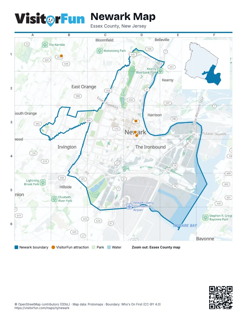
Street index of Newark
Each street on the sheet and the grid squares it crosses.
- Bridge StreetD1, D3
- BroadwayD1, D2, D3
- Clifton AvenueD1, D2, D3
- Elwood AvenueD1, D2
- Franklin AvenueD1
- Grafton AvenueD1, D2
- Heller ParkwayD1
- Lake StreetD1, D2
- McCarter HighwayD1, E1, D2, D3, C4, D4, D5
- Mill StreetD1
- Mount Prospect AvenueD1, D2
- North 6th StreetD1, C2, D2, C3
- Summer AvenueD1, D2, D3
- Union AvenueD1
- Verona AvenueD1
- Washington AvenueD1
- 4th Avenue WestC2
- Bloomfield AvenueC2, D2
- Essex FreewayC2, C3, D3
- Gould AvenueC2
- North 1st StreetC2, C3
- North 4th StreetC2
- Orange StreetC2, C3, D3
- Park AvenueC2, D2
- Roseville AvenueC2, C3
- South 11th StreetC2, C3, C4
- South 12th StreetC2, C3, C4
- Springdale AvenueC2
- West Market StreetC2, C3, D3
- 2nd AvenueD2
- 3rd AvenueD2
- Bloomfield PlaceD2
- Broad StreetD2, D3, C4, D4
- Chester AvenueD2
- Clark StreetD2
- Dr. Martin Luther King Jr. BoulevardD2, D3, C4
- Passaic StreetD2, D3
- Riverside AvenueD2
- Eastern ParkwayA3, B3
- Irvington AvenueA3
- Manor DriveA3
- Mount Vernon PlaceA3, B3
- Putnam StreetA3
- Wilden PlaceA3
- 14th AvenueB3
- 18th AvenueB3, C3, C4
- Alexander StreetB3
- Garden State ParkwayB3
- Kerrigan BoulevardB3, A4
- Maybaum AvenueB3
- Mt Vernon Place EastB3
- Myrtle AvenueB3
- North Munn AvenueB3
- Orange AvenueB3
- Oraton ParkwayB3
- Sanford AvenueB3
- Sanford StreetB3
- South Devine StreetB3
- South Orange AvenueB3, C3, D3
- Speedway AvenueB3
- Stuyvesant AvenueB3
- Tremont AvenueB3
- Valley StreetB3
- West Allen StreetB3
- Whittlesey AvenueB3
- 12th AvenueC3
- 15th AvenueC3
- 1st StreetC3
- 2nd StreetC3
- Bergen StreetC3, C4, B5, C5
- Central AvenueC3, D3
- Court StreetC3, D3, D4
- Freeway DriveC3
- Gould PlaceC3
- Grove StreetC3
- Irvine Turner BoulevardC3, C4
- Jones StreetC3
- Morris AvenueC3
- Muhammad Ali AvenueC3, C4
- Norfolk StreetC3, D3
- South 18th StreetC3, B4
- South 8th StreetC3
- Springfield AvenueC3, D3, B4, C4
- Sussex AvenueC3, D3
- Warren StreetC3, D3
- West Kinney StreetC3, D4
- William StreetC3, D3
- 7th AvenueD3
- 8th AvenueD3
- Adams StreetD3, D4
- Broad Street / Kenneth A. Gibson BoulevardD3
- Center StreetD3
- Clay StreetD3
- Dr. Martin Luther King Jr. Boulevard / High StreetD3
- Ferry StreetD3, E3, D4, E4
- Grant StreetD3
- Jackson StreetD3, D4
- James StreetD3
- Lackawanna AvenueD3
- Lafayette StreetD3, D4
- Lock StreetD3
- Lombardy PlaceD3
- Lombardy StreetD3
- Market StreetD3, E4
- Mulberry StreetD3, D4
- Nesbitt StreetD3
- Park PlaceD3
- Raymond BoulevardD3, E3, F3
- Raymond Plaza EastD3
- Spring StreetD3, C6
- State StreetD3
- Summit StreetD3
- University AvenueD3, D4
- Van Buren StreetD3, D4
- Washington StreetD3, D4
- New Jersey Turnpike Eastern SpurE3, E4
- New Jersey Turnpike Western SpurE3, E4
- Pulaski SkywayE3, F3
- Doremus AvenueF3, E4, F4, E5
- Lincoln HighwayF3
- Florence AvenueA4
- Chancellor AvenueB4, B5, C5
- Clinton AvenueB4, C4, D4
- Clinton PlaceB4, C4
- Fabyan BridgeB4
- Fabyan PlaceB4, B5
- Hawthorne AvenueB4, C4
- Lyons AvenueB4, B5, C5
- Nye AvenueB4, C4
- Phillipsburg–Newark ExpresswayB4, C4, D4, C5, D5
- Selvage StreetB4
- Wainwright StreetB4
- Wolcott TerraceB4, C4
- Avon AvenueC4
- East Bigelow StreetC4
- East Peddie StreetC4
- East Runyon StreetC4
- Elizabeth AvenueC4, C5
- Emmet StreetC4, D4
- Frelinghuysen AvenueC4, C5
- Osborne TerraceC4, B5, C5
- Poinier StreetC4
- Poinier Street/Route 27C4
- Ridgewood AvenueC4
- Spruce StreetC4, D4
- Watson AvenueC4, C5
- West Bigelow StreetC4
- West Peddie AvenueC4
- West Peddie StreetC4
- West Runyon StreetC4
- Avenue ID4
- Backus StreetD4
- Chestnut StreetD4
- Delancy StreetD4, E4
- East Kinney StreetD4
- Frontage RoadD4
- Lang StreetD4
- Lincoln ParkD4
- Merchant StreetD4
- Miller StreetD4
- Pacific StreetD4
- South StreetD4
- Stockton StreetD4, E4
- Walnut StreetD4
- Wilson AvenueD4, E4
- Wright StreetD4
- Avenue LE4
- Avenue PE4
- New Jersey TurnpikeE4, D5, E5
- Roanoke AvenueE4
- Rutherford StreetE4
- Saint Charles StreetE4
- US 1-9 LocalE4, C5
- Maple AvenueB5
- Summit AvenueB5
- Brewster RoadC5, D5
- Carson RoadC5, C6
- Colonel Roberts RoadC5, C6
- Empire StreetC5
- Express RoadC5, D5, C6, D6
- Haynes AvenueC5
- Hotel RoadC5, D5
- Lindbergh RoadC5
- McClellan StreetC5, C6
- Meeker AvenueC5
- North BridgeC5, C6
- Parking A Access RoadC5
- South Directory RoadC5, C6
- Tower RoadC5, D5, C6, D6
- Victoria StreetC5
- Corbin StreetD5, E5
- Executive DriveD5
- New Jersey Turnpike Newark Bay ExtensionD5, E5
- Port StreetD5, E5
- Terminal B - ArrivalsD5, D6
- Terminal B - Departures - Level 2D5, D6
- Terminal B - Departures - Level 3D5, D6
- Terminal C - ArrivalsD5
- Terminal C - DeparturesD5
- Terminal B - DeparturesD6
Things to do on the Newark map
Places on the map
- Anheuser-Busch Newark Brewery
- Area 340
- ArtSide
- Aspen Riverpark
- Ball Park
- Branch Brook Park
- Building 340
- C&C Yard 1
- C&C Yard 2
- Covanta Essex Company
- Delaney Hall
- dsm-firmenich Firchem
- East Ferry Neighborhood
- Essex County Correctional Facility
- Essex County Law Library
- Essex Generating Station
- Fabuwood Carpentry
- Fairmount Cemetery
- Gateway Center
- Georgia King Village
- Grove Street Cemetery
- Hansbury Avenue
- Harriet Tubman Square
- Hertz Equipment Services
- High Park Apartments
- Holy Sepulchre Cemetery
- Independence Park
- Ironbound Recreation Center
- Ivy Hill Park
- Ivy Hill Park Apartments
- Janice Cromer Village
- Jesse Allen Park
- Lionsgate Studios
- Madison Area Branch Newark Public Library
- Marcam Supply Company
- McKinley Elementary School
- Mount Olivet Cemetery
- Mount Pleasant Cemetery
- Mount Vernon Elementary School
Next to Newark
- Bayonne
- Belleville
- Bloomfield
- East Orange
- Harrison
- Hillside
- Irvington
- Kearny
- North Arlington
- Orange
- South Orange
- Union
© OpenStreetMap contributors (ODbL) · Map data: Protomaps · Boundary: Who's On First (CC-BY 4.0)