

New Mexico map
Chaves County map
About 63,697 people live here (Census Bureau, 2024 estimate). The sheet's index lists 300 streets; Red Bluff Loop Road, Felix Canyon Road and Olive Road cross the most grid squares. Things to do inside the boundary: International UFO Museum and Research Center.
Open the map (PDF, US Letter)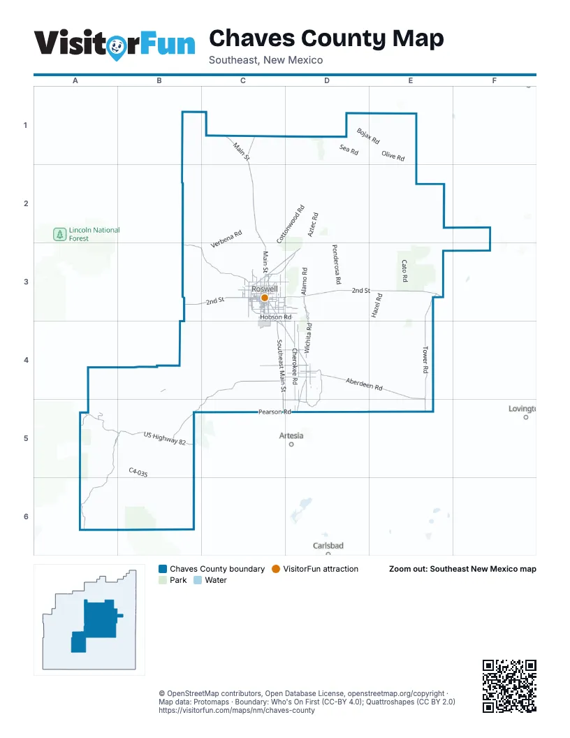
Street index of Chaves County
Each street on the sheet and the grid squares it crosses.
- North Main StreetC1, C2, C3
- Southeast Main StreetC3, C4, C5
- West 2nd StreetB3, C3
- US Highway 82A5, B5
- East 2nd StreetC3, D3, E3
- Clovis HighwayC3, D3
- 2nd StreetE3, D4
- Relief RouteC3
- South Main StreetC3
- Fort Sumner RoadC1
- White Mill RoadC3
- West Relief RouteC3
- Highway Relief RouteC3
- Hope HighwayB5
- Sagebrush Valley RoadC4, B5, C5
- Aberdeen RoadD4, E4
- Tower RoadE3, E4, E5
- Pinon Dunken RoadA5, B5, A6
- West Pine Lodge RoadB3, C3
- Wichita RoadD3, D4, D5
- Old Dexter HighwayC3, C4, D4
- Old Clovis HighwayC3, D3
- Spokan RoadD4, D5
- East Hobson RoadC3, D3
- West Country Club RoadC3
- East Pine Lodge RoadC3, D3
- East Shawnee RoadC4, D4
- North Atkinson AvenueC3
- North Sycamore AvenueC3
- East Brasher RoadC3
- South Sunset AvenueC3
- West College BoulevardC3
- West McGaffey StreetC3
- South Atkinson AvenueC3
- West Brasher RoadC3
- East McGaffey StreetC3
- South Union AvenueC3
- East College BoulevardC3
- North Union AvenueC3
- Yakima RoadC4
- West Hobson RoadC3
- East Earl Cummings LoopC3
- West Hobbs StreetC3
- East Hobbs StreetC3
- West Earl Cummings LoopC3
- Walker BoulevardC3
- Sunset PlaceC3
- Shawnee RoadC4, D4
- West Earl Cummings BoulevardC3
- Lake Arthur HighwayD5
- West Aberdeen StreetD4
- East Aberdeen StreetD4
- Elford AvenueD4
- 1st StreetD4
- Earl Cummings LoopC3
- North Sunset AvenueC3
- Brasher RoadC3
- McGaffey StreetC3
- Cherokee RoadC3, D4, D5
- Buffalo Valley RoadD4, D5
- Lincoln AvenueC3, D4, D5
- Bottomless Lakes RoadD3
- East Ottawa RoadC4, D4
- Cornucopia Canyon RoadA6
- East Grand Plains RoadC3, D3
- West Pearson RoadC5
- East Chickasaw RoadC4, D4
- Y O RoadC3, C4
- East Morgan RoadD4
- Woodbine WayC3, D3
- West Chickasaw RoadC4
- Mono RoadD4
- Wrangler RoadC3
- South Brown RoadC3
- West Berrendo RoadC3
- South Lea AvenueC3
- North Montana AvenueC3
- Elk Canyon RoadA5
- East Pearson RoadC5, D5
- Pueblo RoadC5, D5
- West Alameda StreetC3
- Mark RoadC3
- North Red Bridge RoadC3
- North Brown RoadC3
- South Lincoln AvenueC3, D4, D5
- North Garden AvenueC3
- North Washington AvenueC3, D4
- East CrossroadsC4, D4
- North Eisenhower RoadC3
- South Washington AvenueC3
- East Bland StreetC3
- East 19th StreetC3
- South Eisenhower RoadC3
- West Bland StreetC3
- West 8th StreetC3
- East Berrendo RoadC3
- South Pennsylvania AvenueC3
- North Kentucky AvenueC3
- East Poe StreetC3
- Seminole RoadC3
- East Mescalero RoadC3
- West Mescalero RoadC3
- South Hummingbird LaneC3, C4
- Riverside DriveC3
- Omaha RoadC3
- Lipan RoadC3
- East Alameda StreetC3
- West Poe StreetC3
- West Summit StreetC3
- School RoadC3
- West 4th StreetC3, D4
- East Country Club RoadC3
- East Gallina RoadC3
- West Jaffa StreetC3
- South Garden AvenueC3
- South Wyoming AvenueC3
- North Lea AvenueC3
- South Richardson AvenueC3
- West CrossroadsC4
- Lovers LaneC3
- Avenida de Vista RoadC3
- West Deming StreetC3
- North Pennsylvania AvenueC3
- South Virginia AvenueC3
- Meadow Brook RoadC3
- North Grand AvenueC3
- North Richardson AvenueC3
- County Road 40B4
- East Summit StreetC3
- Dusty Miller RoadC3
- Railroad RoadC3
- Moore AvenueC3
- West 7th StreetC3
- West 19th StreetC3
- Monksdale RoadC3
- North Virginia AvenueC3
- O Connor RoadC3
- West Gayle StreetC3
- Wooldridge-Margaret RoadC3
- Rocking Chair RoadC3, C4
- South Red Bridge RoadC3
- East Charleston RoadC3
- North Urton RoadC3
- South Sycamore AvenueC3
- East 5th StreetC3
- West 5th StreetC3
- Sherrill LaneC3
- Cedarvale RoadC3, D3
- West Chisum StreetC3
- East 23rd StreetC3
- Marion Richards RoadC3
- East Chisum StreetC3
- Argyle StreetD4
- East 4th StreetC3
- Crooked Creek RoadC3
- East Marker RoadC3
- Wilshire BoulevardC3
- Fowler RoadC3
- West Mountain View RoadC3
- East Martin StreetC3
- La Jara RoadC3
- West Argyle StreetD4
- North Wyoming AvenueC3
- 11th StreetC3, D5
- West Martin StreetC3
- Cumbres RoadC3
- East 1st StreetC3
- Jerry Smith CircleC3, C4
- Berrendo RoadC3
- Saint Mary's PlaceC3
- Pearson RoadD5
- Summit StreetC3
- North 13th StreetD5
- C3-049D4
- 16 Springs Canyon RoadA5
- Jaffa StreetC3
- Mountain View RoadC3
- Poe StreetC3
- Gallina RoadC3
- Mescalero RoadC3
- Bland StreetC3
- Deming StreetC3
- Red Bluff Loop RoadC1, D1, C2, D2
- Felix Canyon RoadA4, B4, A5, B5
- Olive RoadD1, E1, D2, E2
- Cottonwood RoadC2, D2, C3
- Railroad Mountain RoadD2, E2, E3
- San Patricio RoadD1, E1
- Twin Butte Canyon RoadB4, C4
- Rock House RoadC2
- Verbena RoadC2, B3, C3, C5
- Wilkerson Well RoadA6, B6
- Old Y O Crossing RoadC4
- Mossman RoadB3, C3, C4
- Aztec RoadD2, D3
- C4-035A5, B5
- Ponderosa RoadD2, D3
- Buck Horn - Chaves County Part RoadB6
- Bojax RoadD1, E1
- White Lake Ranch RoadD2, E2, D3, E3
- Katrina RoadD4, E4
- Red Bluff RoadC2, D2
- Tinnie RoadE1
- Russell Gap RoadA6, B6
- Mathers RoadE3
- Merlinda RoadD4
- Cauhape Ranch RoadA5, B5
- Bear Canyon RoadB6
- Walnut Draw RoadC5
- Squaw Canyon RoadB4, B5
- Vineyard RoadD4
- Sea RoadD1
- Chesser RoadC4
- Rat Camp RoadD4, D5
- Shoshoni RoadD4
- Magdalena RoadD3
- Columbine RoadC2, C3
- Cato RoadE3
- Johnson RoadC3, B4, C4
- Nogeezi RoadE2, F2, F3
- Little Draw RoadA6
- Roosevelt RoadD2
- Hazel RoadE3, E4
- Harriet RoadD4, D5
- Ledoux RoadF2, F3
- Hachita RoadD3
- Picacho RoadB5
- Bitterroot RoadC2
- Cuevo Canyon RoadA5
- Alamo RoadD3
- Stargrass RoadC2
- Colfax RoadC1, D1
- Helena RoadB5
- Terry RoadB6
- Buchanan RoadC3, C4
- East Ojibwa RoadC4, D4
- Chaves RoadC2, D2
- Refuge RoadD3
- Aleut RoadD3
- Hanover RoadE2
- Old Chisum TrailD4
- Suzanne RoadD4, E4
- Red Hill RoadD1
- Cindy RoadE4
- Rim RoadB6
- Moon Ranch RoadE2, F2
- Old School House RoadB4, A5, B5
- Reserve RoadF2, F3
- Champion Canyon RoadA5
- Draper RoadB3, C3
- Jennings RanchB5
- Hagerman Cutoff RoadE4, E5
- Jicarilla RoadC3, D4
- Bullis Canyon RoadB6
- Lingo RoadE2
- Gainer RoadD1, E1, E2
- Lincoln RoadD3, D4
- Larkspur RoadC3
- East Orchard Park RoadC4, D4
- East Darby RoadC4, D4
- East Anita RoadD4
- Eddy RoadD2
- Two Rivers Dam RoadC3, C4
- Caddo RoadC4, D4
- Grant RoadD1
- Honolulu RoadC4
- Zubi RoadC4
- Choctaw RoadD4
- Capitan RoadC3
- River RoadD3
- Collins Canyon RoadA6
- Chimney Lake RoadA5
- Spike Box RoadC1
- East Anasazi RoadC4, D4
- McKinley RoadD1
- Mora RoadD2
- Inez RoadE3
- East Cheyenne RoadC4, D4
- Sam Lewis Canyon RoadA6, B6
- Austin RoadC5
- Donna RoadD3
- Taos RoadC2, D2
- South Graves RoadC3, C4
- East Calusa RoadC4, D4
- Navajo RoadC3, D4
- Guadalupe Rim RoadB6
- Felix Ranch RoadD4
- County Road 26B5, A6, B6
- Ocate RoadD2
- East Jackson RoadC5, D5
- Bitter Lakes RoadC3, D3
- Buck Tank RoadB6
- Elida RoadE1
- South Baker RoadD3, D4
- Bronc RoadB6
- Christy RoadD4
- Torrence RoadD1
- Silverweed RoadC2
- C3-144C4
- Consuelo RoadE4
Things to do on the Chaves County map
Places on the map
- Anchor D Ranch
- Antelope Lake
- Bitter Lake
- Bitter Lake National Wildlife Refuge
- Bottomless Lakes State Park
- Brooks Tank
- Cahoon Park
- Chaparral Skeet Club
- Cielo Grande Park
- Cocklebur Lakes
- Corn Ranch
- Curlew Lake
- Dexter
- Dimmitt Lake
- Felix River Ranch
- Goddard High School
- Hagerman
- Haystack Mountain Off-Highway Vehicle Area
- Hondo Reservoir
- Hrvatska
- Johnson Lake
- Johnson Ranch
- Juan Lake
- L-E Ranch
- Lake Arthur
- Lake Van
- Lazy Lagoon
- Lea Lake
- Lesser Prairie Chicken Habitat Preservation Area of Critical Environmental Concern
- Little Red Lake
- Mathers Wilderness Study Area
- New Mexico Military Institute Golf Course
- North Pecos River Area of Critical Environmental Concern
- Overflow Wetlands Area of Critical Environmental Concern
- Philley Tank
- Roswell
- Salt Creek Wilderness
- Salt Lake
- Sardine Lake
- Silman Lake
Next to Chaves County
- Artesia
- Carlsbad
- Lovington
© OpenStreetMap contributors, Open Database License, openstreetmap.org/copyright · Map data: Protomaps · Boundary: Who's On First (CC-BY 4.0); Quattroshapes (CC BY 2.0)